Location
Latitude: |
33-58-41.1310N (33.978092) |
Longitude: |
083-57-44.5100W (-83.962364) |
Elevation: |
1061.5 feet MSL (324 m MSL) |
Magnetic Variation: |
5.8 W (as of April 2024 from WMM2020 model) |
Time Zone: |
UTC -5.0 (Standard Time) UTC -4.0 (Daylight Savings Time) |
From City: |
02 N.M. NE of Lawrenceville, Georgia |
Found On: |
Atlanta Chart |
FAA Region: |
ASO |
Contacts
Manager: |
Publicly owned: |
| MATTHEW SMITH 600 BRISCOE BLVD LAWRENCEVILLE, GA 30046 770-822-5196 |
GWINNETT COUNTY 75 LANGELY DR LAWRENCEVILLE, GA 30046 770-822-7000 |
Operations
Airport Status: |
Operational |
Facility Use: |
Public |
Type: |
Airport |
Activation Date: |
10/1963 |
Control tower: |
Yes |
Attendance (Months/Days/Hours): |
Months/Days/Hours ALL/ALL/ALL |
Boundary ARTCC: |
ZTL (Atlanta) |
Responsible ARTCC: |
ZTL (Atlanta) |
Lighting Schedule: |
SEE RMK |
Segmented Circle Indicator: |
Yes |
Traffic Pattern Altitude (MSL): |
2062 feet (628 m) |
NOTAMs Facility: |
LZU |
NOTAM-D Service: |
Yes |
International Airport of Entry: |
No |
Customs Landing Rights: |
No |
Military Landing Rights: |
Yes |
Civil/Military Joint Use: |
No |
Based Aircraft
| Single Engine: | 145 |
| Multi Engine: | 39 |
| Jet Engine: | 40 |
| GA Helicopters: | 12 |
Annual Operations (as of 12/31/2022)
| Total Operations: | 82895 | |
| GA Local: | 49081 | 59.2% |
| GA Itinerant: | 32694 | 39.4% |
| Military Aircraft: | 1120 | 1.4% |
Communications
| CTAF: | 124.100 |
| Unicom: | 123.050 |
| Tower: | GWINNETT 124.1 Hrs: 0700-2100 |
| Clearance Del.: | 121.8 |
| Ground: | 121.8 |
| Approach: | ATLANTA |
| Departure: | ATLANTA |
| ATIS: | 132.275 Hrs: 24 |
| AWOS-3PT: | (770-339-7753) |
Fixed Based Operators (FBOs) & Fuel
(Click on a business for detail)
Please help us keep this information up to date. This is a FREE SERVICE just like everything else on Airport Guide! If you see that a business needs to be added, modified, or deleted please fill out our Update Form.
To add, modify, or delete a business click here.
Please help us keep this information up to date. This is a FREE SERVICE just like everything else on Airport Guide! If you see that a business needs to be added, modified, or deleted please fill out our Update Form.
Area Code: 770 |
| Business Name | Frequency | Phone | Fuel Grade |
|---|---|---|---|
| Astron Enterprises, Inc.
Update FBO info |
682-9949 | ||
| Atlanta Jet A, Inc.
Update FBO info |
338-1552 | 100LL, Jet A | |
| Hawthorne Gwinnett
Update FBO info |
Unicom 123.05 | 995-5592 | 100LL, Jet A |
Flight Service Stations
| Primary | Alternate | |
| FSS on Field: | N | |
| FSS Name (ID): | Macon(MCN) | |
| Frequency: | ||
| Toll Free Phone: | 1-800-WX-BRIEF |
Instrument Procedures / Charts
FAA Terminal Procedures valid from 0901Z 03/21/24 to 0901Z 04/18/24.
There are various types of charts available for an airport. They are listed in the Page Type column. Here is a legend for those types:
APD - Airport Diagram
DP - Departure Procedure Charts
HOT - Hot Spots
IAP - Instrument Approach Procedure Charts
MIN - Minimums
STAR - Standard Terminal Arrival Charts
| Page Type | Page Name | Volume | Action Since Last Cycle |
|---|---|---|---|
| APD | AIRPORT DIAGRAM | SE-4 | |
| IAP | ILS OR LOC RWY 25 | SE-4 | |
| IAP | RNAV (GPS) RWY 07 | SE-4 | |
| IAP | RNAV (GPS) RWY 25 | SE-4 | |
| MIN | ALTERNATE MINIMUMS | SE-4 | |
| MIN | TAKEOFF MINIMUMS | SE-4 | |
| STAR | BOKRT THREE (RNAV) | SE-4 | |
| STAR | BUKHD THREE (RNAV) | SE-4 | |
| STAR | DEHAN THREE (RNAV) | SE-4 | |
| STAR | DEHAN THREE (RNAV)[DELIMITER] CONT.1 | SE-4 | |
| STAR | SWTEE TWO (RNAV) | SE-4 | |
| STAR | WRGNZ THREE (RNAV) | SE-4 |
Terminal Procedures are only available for airports in several countries with more being added all the time. If you are looking for a specific country's charts, please send an email to support(at)airportguide.com stating the country name. This will be used to prioritize the implementation.
Navigation Aids (Navaids) near KLZU
| Dist (NM) | ID | Morse Code | Name | Type | Freq | True Hdg | Mag Hdg |
|---|---|---|---|---|---|---|---|
| 5.6 | TX | _ _ . . _ | Gwnet | NDB | 419 | 63 | 69 |
| 13.8 | FKV | . . _ . _ . _ . . . _ | Flowery Branch | NDB | 365 | 11 | 17 |
| 17.8 | PDK | . _ _ . _ . . _ . _ | Peachtree | VOR-DME | 116.60 | 249 | 255 |
| 18.6 | JNM | . _ _ _ _ . _ _ | Monroe | NDB | 392 | 140 | 146 |
| 18.7 | BMW | _ . . . _ _ . _ _ | Barrow County | NDB | 404 | 97 | 103 |
| 22.5 | DDA | _ . . _ . . . _ | Commerce | NDB | 244 | 76 | 82 |
| 22.8 | VOF | . . . _ _ _ _ . . _ . | Alcovy | NDB | 370 | 156 | 162 |
| 26.5 | BR | _ . . . . _ . | Redan | NDB | 266 | 221 | 227 |
| 27.4 | DOB | _ . . _ _ _ _ . . . | Dobbins | TACAN | 113.00 | 262 | 268 |
| 30.0 | ATL | . _ _ . _ . . | Atlanta Muni | VOT | 111.00 | 230 | 236 |
| 30.5 | GSU | _ _ . . . . . . _ | Atlanta | DME | 116.9 | 227 | 233 |
| 30.8 | DJD | _ . . . _ _ _ _ . . | Chero | NDB | 415 | 302 | 308 |
| 31.6 | ATL | . _ _ . _ . . | Atlanta | DME | 116.9 | 228 | 234 |
| 31.8 | AHN | . _ . . . . _ . | Athens | VOR-DME | 116.95 | 93 | 99 |
| 36.1 | FT | . . _ . _ | Flanc | NDB | 344 | 249 | 255 |
| 37.0 | BJT | _ . . . . _ _ _ _ | Bulldog | NDB | 221 | 92 | 98 |
| 37.5 | AJR | . _ . _ _ _ . _ . | Habersham | NDB | 347 | 32 | 38 |
| 45.7 | EVZ | . . . . _ _ _ . . | Cartersville | NDB | 308 | 287 | 293 |
| 48.3 | FFC | . . _ . . . _ . _ . _ . | Pecat | NDB | 316 | 212 | 218 |
| 50.9 | VV | . . . _ . . . _ | Junne | NDB | 353 | 112 | 118 |
Nearby Airports with Fuel
Notices to Airmen (NOTAMS)
Remarks
| A110-1 | TWY T HAS NSTD MRKNG. |
| A81-APT | WHEN ATCT CLSD ACTVT MALSR RWY 25; HIRL RWY 7/25 - CTAF. |
| A83 | SECONDARY WIND ANEMOMETER SENSOR ON FIELD SUPPORTING ATCT OPS. |
| E147 | TPA FOR LIGHT ACFT 1039 FT; TPA FOR JET & TURBO PROP ACFT 1539 FT. |
Runways
Runway Summary
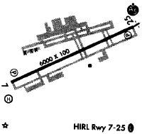
| Runways: | 07/25 |
| Longest Runway: | 07/25 is 6001 ft (1829 m) long |
| Runways with an Instrument Approach: | 25 |
KLZU Airport Runway Details
| Runway 07/25 | 6001 ft x 100 ft (1829 m x 30 m) | |
| Runway Length Source: | 3RD PARTY SURVEY as of 03/25/2021 | |
| Surface: | Asphalt - Good condition - Saw-cut or plastic grooved | |
| Runway Pavement Class: | 37 /F/D/W/T | |
| Runway Edge Lights: | High Intensity | |
Runway Weight Bearing Capacity (in thousands of pounds) |
||
| Single Wheel Landing Gear: | 93.0 | |
| Dual Wheel Landing Gear: | 120.0 | |
Runway 07 |
Runway 25 |
|
Elevation: |
1061.5 | 1031.4 |
Latitude: |
33-58-27.9767N | 33-58-54.2829N |
Longitude: |
083-58-16.4451W | 083-57-12.5717W |
|
Runway True Alignment: |
064 | 244 |
ILS Type: |
ILS | |
Glide Path Angle: |
3.0 degrees | 3.0 degrees |
Runway Markings Type: |
Precision Instrument | Precision Instrument |
Runway Markings Condition: |
Good | Good |
Object at End: |
POLE | TREES |
Object Height: |
48 | 10 |
Distance from End: |
1160 | 301 |
Object Centerline Offset: |
511 ft. right of centerline | 505 ft. left of centerline |
Visual Glide Slope Indicators: |
2-Light PAPI On Left Side Of Runway | 2-Light PAPI On Left Side Of Runway |
Approach Light System: |
1,400 Foot Medium Intensity Approach Lighting System With Runway Alignment Indicator Lights | |
Threshold Crossing Height: |
41 | 48 |
Services
Airframe Repair: |
Major |
Powerplant Repair: |
Major |
Bottled Oxygen: |
None |
Bulk Oxygen: |
None |
Fuel Available: |
100LL, Jet A+ |
Landing Fees: |
No |
Parking: |
Tiedowns available |
Maps & Diagrams
KLZU Sectional
Flight Planning
at skyvector.com
at skyvector.com