Location
Latitude: |
33-18-41.6360N (33.311566) |
Longitude: |
084-46-11.1195W (-84.769755) |
Elevation: |
970.2 feet MSL (296 m MSL) |
Magnetic Variation: |
5.2 W (as of April 2024 from WMM2020 model) |
Time Zone: |
UTC -5.0 (Standard Time) UTC -4.0 (Daylight Savings Time) |
From City: |
04 N.M. S of Atlanta, Georgia |
Found On: |
Atlanta Chart |
FAA Region: |
ASO |
Contacts
Manager: |
Publicly owned: |
| CALVIN WALKER 115 AIRPORT ROAD, BOX 2 NEWNAN, GA 30263 770-254-8102 |
NEWNAN & COWETA CO ARPT AUTH 115 AIRPORT ROAD, BOX 2 NEWNAN, GA 30263 770-254-8102 |
Operations
Airport Status: |
Operational |
Facility Use: |
Public |
Type: |
Airport |
Control tower: |
No |
Attendance (Months/Days/Hours): |
Months/Days/Hours ALL/M-F/0700-2000 |
Boundary ARTCC: |
ZTL (Atlanta) |
Responsible ARTCC: |
ZTL (Atlanta) |
Lighting Schedule: |
SEE RMK |
Segmented Circle Indicator: |
Yes |
Traffic Pattern Altitude (MSL): |
1970 feet (600 m) |
NOTAMs Facility: |
MCN |
NOTAM-D Service: |
Yes |
International Airport of Entry: |
No |
Customs Landing Rights: |
No |
Military Landing Rights: |
Yes |
Civil/Military Joint Use: |
No |
Based Aircraft
| Single Engine: | 125 |
| Multi Engine: | 9 |
| Jet Engine: | 7 |
| GA Helicopters: | 3 |
Annual Operations (as of 12/31/2022)
| Total Operations: | 50000 | |
| GA Local: | 30000 | 60.0% |
| GA Itinerant: | 20000 | 40.0% |
Communications
| CTAF: | 122.700 |
| Unicom: | 122.700 |
| Approach: | ATLANTA 119.8 119.8 |
| Departure: | ATLANTA 119.8 119.8 |
| AWOS-3PT: | 118.975 (770-254-1617) |
Fixed Based Operators (FBOs) & Fuel
(Click on a business for detail)
Please help us keep this information up to date. This is a FREE SERVICE just like everything else on Airport Guide! If you see that a business needs to be added, modified, or deleted please fill out our Update Form.
To add, modify, or delete a business click here.
Please help us keep this information up to date. This is a FREE SERVICE just like everything else on Airport Guide! If you see that a business needs to be added, modified, or deleted please fill out our Update Form.
Area Code: 770 |
| Business Name | Frequency | Phone | Fuel Grade |
|---|---|---|---|
| Fulton Airtronics, Inc.
Update FBO info |
253-8282 |
Flight Service Stations
| Primary | Alternate | |
| FSS on Field: | N | |
| FSS Name (ID): | Macon(MCN) | |
| Frequency: | ||
| Toll Free Phone: | 1-800-WX-BRIEF |
Instrument Procedures / Charts
FAA Terminal Procedures valid from 0901Z 03/21/24 to 0901Z 04/18/24.
There are various types of charts available for an airport. They are listed in the Page Type column. Here is a legend for those types:
APD - Airport Diagram
DP - Departure Procedure Charts
HOT - Hot Spots
IAP - Instrument Approach Procedure Charts
MIN - Minimums
STAR - Standard Terminal Arrival Charts
| Page Type | Page Name | Volume | Action Since Last Cycle |
|---|---|---|---|
| IAP | ILS OR LOC RWY 33 | SE-4 | |
| IAP | RNAV (GPS) RWY 15 | SE-4 | |
| IAP | RNAV (GPS) RWY 33 | SE-4 | |
| MIN | ALTERNATE MINIMUMS | SE-4 | |
| MIN | TAKEOFF MINIMUMS | SE-4 | |
| STAR | BUKHD THREE (RNAV) | SE-4 | |
| STAR | DEHAN THREE (RNAV) | SE-4 | |
| STAR | DEHAN THREE (RNAV)[DELIMITER] CONT.1 | SE-4 |
Terminal Procedures are only available for airports in several countries with more being added all the time. If you are looking for a specific country's charts, please send an email to support(at)airportguide.com stating the country name. This will be used to prioritize the implementation.
Navigation Aids (Navaids) near KCCO
| Dist (NM) | ID | Morse Code | Name | Type | Freq | True Hdg | Mag Hdg |
|---|---|---|---|---|---|---|---|
| 4.3 | EQQ | . _ _ . _ _ _ . _ | Coweta County | NDB | 234 | 139 | 144 |
| 14.2 | FFC | . . _ . . . _ . _ . _ . | Pecat | NDB | 316 | 92 | 97 |
| 23.7 | GPQ | _ _ . . _ _ . _ _ . _ | Carrollton | NDB | 278 | 310 | 315 |
| 25.3 | ATL | . _ _ . _ . . | Atlanta | DME | 116.9 | 41 | 46 |
| 26.3 | GSU | _ _ . . . . . . _ | Atlanta | DME | 116.9 | 42 | 47 |
| 27.0 | ATL | . _ _ . _ . . | Atlanta Muni | VOT | 111.00 | 39 | 44 |
| 27.0 | LGC | . _ . . _ _ . _ . _ . | Lagrange | VORTAC | 115.60 | 234 | 239 |
| 27.8 | FT | . . _ . _ | Flanc | NDB | 344 | 13 | 18 |
| 28.6 | PIM | . _ _ . . . _ _ | Pine Mountain | NDB | 272 | 190 | 195 |
| 30.5 | BR | _ . . . . _ . | Redan | NDB | 266 | 48 | 53 |
| 37.6 | OP | _ _ _ . _ _ . | Yates | NDB | 339 | 128 | 133 |
| 38.5 | DOB | _ . . _ _ _ _ . . . | Dobbins | TACAN | 113.00 | 19 | 24 |
| 41.2 | PDK | . _ _ . _ . . _ . _ | Peachtree | VOR-DME | 116.60 | 34 | 39 |
| 43.6 | CSG | _ . _ . . . . _ _ . | Columbus | TACAN | 117.10 | 196 | 201 |
| 53.0 | VOF | . . . _ _ _ _ . . _ . | Alcovy | NDB | 370 | 68 | 74 |
| 53.4 | CS | _ . _ . . . . | Fenix | NDB | 355 | 194 | 199 |
| 53.4 | EVZ | . . . . _ _ _ . . | Cartersville | NDB | 308 | 356 | 361 |
| 54.0 | RMG | . _ . _ _ _ _ . | Rome | VORTAC | 115.40 | 341 | 346 |
| 58.1 | JNM | . _ _ _ _ . _ _ | Monroe | NDB | 392 | 63 | 69 |
| 58.2 | DJD | _ . . . _ _ _ _ . . | Chero | NDB | 415 | 13 | 18 |
Nearby Airports with Fuel
Notices to Airmen (NOTAMS)
Remarks
| A110-1 | GCO AVBL ON FREQ 121.725 THRU FLT SVCS. |
| A110-2 | WILDLIFE INVOF ARPT. |
| A110-3 | EXTENSIVE FLIGHT TRAINING ON AND INVOF AIRPORT |
| A110-4 | FOR CD CTC ATLANTA APCH AT 678-364-6131. |
| A58-15 | 15 FT POWER POLES, 139 FT FROM EOR, 355 FT RIGHT OF CNTRLN. |
| A58-33 | 30 FT TREES, 264 FT RIGHT OF CNTRLN AT RWY END OUT TO 200 FT FM RWY END. |
| A81-APT | ACTVT MALSF RWY 33; HIRL RWY 15/33 - CTAF. |
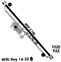
Runways
Runway Summary
| Runways: | 15/33 |
| Longest Runway: | 15/33 is 5500 ft (1676 m) long |
| Runways with an Instrument Approach: | 33 |
KCCO Airport Runway Details
| Runway 15/33 | 5500 ft x 100 ft (1676 m x 30 m) | |
| Runway Length Source: | AVN as of 12/07/2004 | |
| Surface: | Asphalt - Fair condition - No special surface treatment | |
| Runway Edge Lights: | High Intensity | |
Runway Weight Bearing Capacity (in thousands of pounds) |
||
| Single Wheel Landing Gear: | 26.0 | |
| Dual Wheel Landing Gear: | 37.0 | |
Runway 15 |
Runway 33 |
|
Elevation: |
970.2 | 928.9 |
Latitude: |
33-19-02.3100N | 33-18-20.9620N |
Longitude: |
084-46-32.1810W | 084-45-50.0580W |
|
Runway True Alignment: |
139 | 319 |
ILS Type: |
LOC/GS | |
Glide Path Angle: |
3.0 degrees | 3.0 degrees |
Traffic Pattern: |
Left | Left |
Runway Markings Type: |
Precision Instrument | Precision Instrument |
Runway Markings Condition: |
Good | Good |
Object at End: |
TREES | TREES |
Object Height: |
64 | 30 |
Distance from End: |
927 | 201 |
Object Centerline Offset: |
582 ft. left of centerline | 264 ft. right of centerline |
Visual Glide Slope Indicators: |
4-Light PAPI On Left Side Of Runway | 4-Light PAPI On Left Side Of Runway |
Approach Light System: |
1,400 Foot Medium Intensity Approach Lighting System With Sequenced Flashers | |
Threshold Crossing Height: |
40 | 49 |
Services
Airframe Repair: |
Major |
Powerplant Repair: |
Major |
Bottled Oxygen: |
High Pressure / Low Pressure |
Fuel Available: |
100LL, Jet A |
Landing Fees: |
No |
Parking: |
Hangars and tiedowns available |
Maps & Diagrams
KCCO Sectional
Flight Planning
at skyvector.com
at skyvector.com