Location
Latitude: |
33-21-27.8000N (33.357722) |
Longitude: |
084-34-21.1000W (-84.572528) |
Elevation: |
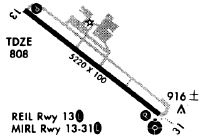
807.7 feet MSL (246 m MSL) |
Magnetic Variation: |
5.3 W (as of April 2024 from WMM2020 model) |
Time Zone: |
UTC -5.0 (Standard Time) UTC -4.0 (Daylight Savings Time) |
From City: |
25 N.M. SW of Atlanta, Georgia |
Found On: |
Atlanta Chart |
FAA Region: |
ASO |
Contacts
Manager: |
Publicly owned: |
| HOPE MACALUSO 7 FALCON DRIVE PEACHTREE CITY, GA 30269 770-487-2225 |
PEACHTREE CITY ARPT AUTH 7 FALCON DRIVE PEACHTREE CITY, GA 30269 770-487-2225 |
Operations
Airport Status: |
Operational |
Facility Use: |
Public |
Type: |
Airport |
Activation Date: |
10/1970 |
Control tower: |
No |
Attendance (Months/Days/Hours): |
Months/Days/Hours ALL/ALL/0700-2000 |
Boundary ARTCC: |
ZTL (Atlanta) |
Responsible ARTCC: |
ZTL (Atlanta) |
Lighting Schedule: |
SEE RMK |
Segmented Circle Indicator: |
Yes |
Traffic Pattern Altitude (MSL): |
1808 feet (551 m) |
NOTAMs Facility: |
FFC |
NOTAM-D Service: |
Yes |
Civil/Military Joint Use: |
No |
Based Aircraft
| Single Engine: | 188 |
| Multi Engine: | 22 |
| Jet Engine: | 7 |
Annual Operations (as of 12/31/2022)
| Total Operations: | 76000 | |
| GA Local: | 41000 | 53.9% |
| GA Itinerant: | 34500 | 45.4% |
| Military Aircraft: | 500 | 0.7% |
Communications
| CTAF: | 123.050 |
| Unicom: | 123.050 |
| Approach: | ATLANTA 119.8 119.8 119.8 |
| Departure: | ATLANTA 119.8 119.8 119.8 |
| ASOS: | 118.525 (770-487-1610) |
Fixed Based Operators (FBOs) & Fuel
(Click on a business for detail)
Please help us keep this information up to date. This is a FREE SERVICE just like everything else on Airport Guide! If you see that a business needs to be added, modified, or deleted please fill out our Update Form.
To add, modify, or delete a business click here.
Please help us keep this information up to date. This is a FREE SERVICE just like everything else on Airport Guide! If you see that a business needs to be added, modified, or deleted please fill out our Update Form.
Area Code: 770 |
| Business Name | Frequency | Phone | Fuel Grade |
|---|---|---|---|
| Falcon Flight School
Update FBO info |
486-1633 | 100LL | |
| Stevens Aviation
Update FBO info |
Unicom 123.05 | 631-5777 | 100LL, Jet A |
Flight Service Stations
| Primary | Alternate | |
| FSS on Field: | N | |
| FSS Name (ID): | Macon(MCN) | |
| Frequency: | ||
| Toll Free Phone: | 1-800-WX-BRIEF |
Instrument Procedures / Charts
FAA Terminal Procedures valid from 0901Z 03/21/24 to 0901Z 04/18/24.
There are various types of charts available for an airport. They are listed in the Page Type column. Here is a legend for those types:
APD - Airport Diagram
DP - Departure Procedure Charts
HOT - Hot Spots
IAP - Instrument Approach Procedure Charts
MIN - Minimums
STAR - Standard Terminal Arrival Charts
| Page Type | Page Name | Volume | Action Since Last Cycle |
|---|---|---|---|
| IAP | ILS OR LOC RWY 31 | SE-4 | |
| IAP | NDB RWY 31 | SE-4 | |
| IAP | RNAV (GPS) RWY 13 | SE-4 | |
| IAP | RNAV (GPS) RWY 31 | SE-4 | |
| MIN | ALTERNATE MINIMUMS | SE-4 | |
| MIN | TAKEOFF MINIMUMS | SE-4 | |
| STAR | BUKHD THREE (RNAV) | SE-4 | |
| STAR | DEHAN THREE (RNAV) | SE-4 | |
| STAR | DEHAN THREE (RNAV)[DELIMITER] CONT.1 | SE-4 |
Terminal Procedures are only available for airports in several countries with more being added all the time. If you are looking for a specific country's charts, please send an email to support(at)airportguide.com stating the country name. This will be used to prioritize the implementation.
Navigation Aids (Navaids) near KFFC
| Dist (NM) | ID | Morse Code | Name | Type | Freq | True Hdg | Mag Hdg |
|---|---|---|---|---|---|---|---|
| 5.5 | FFC | . . _ . . . _ . _ . _ . | Pecat | NDB | 316 | 128 | 133 |
| 9.3 | EQQ | . _ _ . _ _ _ . _ | Coweta County | NDB | 234 | 229 | 234 |
| 17.6 | ATL | . _ _ . _ . . | Atlanta | DME | 116.9 | 22 | 27 |
| 18.4 | GSU | _ _ . . . . . . _ | Atlanta | DME | 116.9 | 25 | 30 |
| 19.4 | ATL | . _ _ . _ . . | Atlanta Muni | VOT | 111.00 | 22 | 27 |
| 21.7 | BR | _ . . . . _ . | Redan | NDB | 266 | 37 | 42 |
| 24.5 | FT | . . _ . _ | Flanc | NDB | 344 | 352 | 357 |
| 30.6 | GPQ | _ _ . . _ _ . _ _ . _ | Carrollton | NDB | 278 | 294 | 299 |
| 32.7 | OP | _ _ _ . _ _ . | Yates | NDB | 339 | 143 | 148 |
| 33.6 | DOB | _ . . _ _ _ _ . . . | Dobbins | TACAN | 113.00 | 5 | 10 |
| 33.9 | PDK | . _ _ . _ . . _ . _ | Peachtree | VOR-DME | 116.60 | 23 | 28 |
| 34.4 | PIM | . _ _ . . . _ _ | Pine Mountain | NDB | 272 | 206 | 211 |
| 36.8 | LGC | . _ . . _ _ . _ . _ . | Lagrange | VORTAC | 115.60 | 239 | 244 |
| 42.8 | VOF | . . . _ _ _ _ . . _ . | Alcovy | NDB | 370 | 67 | 73 |
| 48.0 | JNM | . _ _ _ _ . _ _ | Monroe | NDB | 392 | 61 | 67 |
| 49.9 | CSG | _ . _ . . . . _ _ . | Columbus | TACAN | 117.10 | 206 | 211 |
| 52.3 | EVZ | . . . . _ _ _ . . | Cartersville | NDB | 308 | 345 | 350 |
| 53.2 | TX | _ _ . . _ | Gwnet | NDB | 419 | 41 | 47 |
| 53.8 | DJD | _ . . . _ _ _ _ . . | Chero | NDB | 415 | 4 | 9 |
| 55.5 | RMG | . _ . _ _ _ _ . | Rome | VORTAC | 115.40 | 330 | 335 |
Nearby Airports with Fuel
Notices to Airmen (NOTAMS)
Remarks
| A110-1 | DEER ON AND INVOF OF ARPT. |
| A110-2 | ARPT MOWING IN PROGRESS SPRING THRU AUTUMN. |
| A110-3 | PERIODIC CRANE OPERATIONS 2500' SE APCH END RWY 31 - LIMITED TO 117 AGL. |
| A110-4 | FOR CD CTC ATLANTA APCH AT 678-364-6131. |
| A110-5 | BIRD ACT GEESE IN VCNTY OF ARPT. |
| A57-13 | APCH SLP TO DSPLCD THLD 34:1. |
| A57-31 | APCH SLP TO DSPLCD THLD 34:1. |
| A81-APT | MIRL RWY 13/31 PRESET LOW INTST DUSK-2200; TO INCR INTST & ACTVT AFTER 2200 - CTAF. ACTVT ODALS RWY 31; PAPI RWYS 13 & 31; REIL RWY 13 - CTAF. |
Runways
Runway Summary
| Runways: | 13/31 H1 |
| Longest Runway: | 13/31 is 5768 ft (1758 m) long |
| Runways with an Instrument Approach: | 31 |
KFFC Airport Runway Details
| Runway 13/31 | 5768 ft x 100 ft (1758 m x 30 m) | |
| Runway Length Source: | 3RD PARTY SURVEY as of 11/15/2014 | |
| Surface: | Asphalt - Good condition - No special surface treatment | |
| Runway Edge Lights: | Medium Intensity | |
Runway Weight Bearing Capacity (in thousands of pounds) |
||
| Single Wheel Landing Gear: | 48.0 | |
| Dual Wheel Landing Gear: | 60.0 | |
Runway 13 |
Runway 31 |
|
Elevation: |
800.8 | 807.7 |
Latitude: |
33-21-45.3891N | 33-21-10.1506N |
Longitude: |
084-34-47.8524W | 084-33-54.3644W |
|
Runway True Alignment: |
128 | 308 |
ILS Type: |
ILS/DME | |
Glide Path Angle: |
3.5 degrees | 3.0 degrees |
Traffic Pattern: |
Right | |
Runway Markings Type: |
Nonprecision Instrument | Precision Instrument |
Runway Markings Condition: |
Fair | Fair |
Object at End: |
TREES | ROAD |
Object Height: |
49 | 15 |
Distance from End: |
545 | 296 |
Object Centerline Offset: |
502 ft. left of centerline | 506 ft. right of centerline |
Visual Glide Slope Indicators: |
4-Light PAPI On Left Side Of Runway | 4-Light PAPI On Left Side Of Runway |
Approach Light System: |
Omnidirectional Approach Lighting System | |
REIL: |
Yes | |
Threshold Crossing Height: |
38 | 45 |
Threshold Elevation: |
796.6 | 806.5 |
Displaced Threshold: |
549 | 200 |
Threshold Latitude: |
33-21-42.0358N | 33-21-11.3726N |
Threshold Longitude: |
084-34-42.7610W | 084-33-56.2184W |
Declared Distances |
||
Take Off Run Avbl. (TORA): |
5768 | 5768 |
Take Off Distance Avbl. (TODA): |
5768 | 5768 |
Actual Stop Dist. Avbl. (ASDA): |
5174 | 5318 |
Landing Dist. Avbl. (LDA): |
4625 | 5118 |
| Helipad H1 | 40 ft x 40 ft (12 m x 12 m) | |
| Runway Length Source: | OWNER as of 04/02/2015 | |
| Surface: | Asphalt - Good condition - No special surface treatment | |
Helipad H1 |
||
Elevation: |
797.1 | |
Latitude: |
33-21-29.0300N | |
Longitude: |
084-34-13.7800W | |
Glide Path Angle: |
0.0 degrees | 0.0 degrees |
Object Centerline Offset: |
502 ft. left of centerline | 506 ft. right of centerline |
Services
Airframe Repair: |
Major |
Powerplant Repair: |
Major |
Bottled Oxygen: |
High Pressure / Low Pressure |
Bulk Oxygen: |
High Pressure / Low Pressure |
Fuel Available: |
100LL, Jet A+ |
Landing Fees: |
No |
Parking: |
Tiedowns available |
Maps & Diagrams
KFFC Sectional
Flight Planning
at skyvector.com
at skyvector.com