Location
Latitude: |
39-06-52.9650N (39.114713) |
Longitude: |
087-26-53.9850W (-87.448329) |
Elevation: |
539.2 feet MSL (164 m MSL) |
Magnetic Variation: |
4 W (as of April 2024 from WMM2020 model) |
Time Zone: |
UTC -5.0 (Standard Time) UTC -4.0 (Daylight Savings Time) |
From City: |
03 N.M. NW of Sullivan, Indiana |
Found On: |
St Louis Chart |
FAA Region: |
AGL |
Contacts
Manager: |
Publicly owned: |
| PAT HARMON P.O. BOX 351 SULLIVAN, IN 47882 812-268-6959 |
SULLIVAN COUNTY BOAC P.O. BOX 351 SULLIVAN, IN 47882 812-268-6959 |
Operations
Airport Status: |
Operational |
Facility Use: |
Public |
Type: |
Airport |
Activation Date: |
12/1966 |
Control tower: |
No |
Attendance (Months/Days/Hours): |
Months/Days/Hours ALL/MON-SAT/0800-1700 |
Boundary ARTCC: |
ZID (Indianapolis) |
Responsible ARTCC: |
ZID (Indianapolis) |
Lighting Schedule: |
SEE RMK |
Segmented Circle Indicator: |
No |
Traffic Pattern Altitude (MSL): |
1539 feet (469 m) |
NOTAMs Facility: |
HUF |
NOTAM-D Service: |
Yes |
International Airport of Entry: |
No |
Customs Landing Rights: |
No |
Military Landing Rights: |
Yes |
Civil/Military Joint Use: |
No |
Based Aircraft
| Single Engine: | 20 |
| Multi Engine: | 1 |
Annual Operations (as of 12/31/2019)
| Total Operations: | 5366 | |
| Air Taxi: | 161 | 3.0% |
| GA Local: | 2307 | 43.0% |
| GA Itinerant: | 2898 | 54.0% |
Communications
| CTAF: | 122.800 |
| Unicom: | 122.800 |
| Approach: | HULMAN 119.25 119.25 |
| Departure: | HULMAN 119.25 119.25 |
Fixed Based Operators (FBOs) & Fuel
(Click on a business for detail)
Please help us keep this information up to date. This is a FREE SERVICE just like everything else on Airport Guide! If you see that a business needs to be added, modified, or deleted please fill out our Update Form.
To add, modify, or delete a business click here.
Please help us keep this information up to date. This is a FREE SERVICE just like everything else on Airport Guide! If you see that a business needs to be added, modified, or deleted please fill out our Update Form.
Area Code: 812 |
| Business Name | Frequency | Phone | Fuel Grade |
|---|---|---|---|
| G.P.M. Aviation, Inc.
Update FBO info |
Unicom 122.8 | 268-6959 | 80, 100LL, Jet |
Flight Service Stations
| Primary | Alternate | |
| FSS on Field: | N | |
| FSS Name (ID): | Terre Haute(HUF) | |
| Frequency: | ||
| Toll Free Phone: | 1-800-WX-BRIEF |
Instrument Procedures / Charts
FAA Terminal Procedures valid from 0901Z 03/21/24 to 0901Z 04/18/24.
There are various types of charts available for an airport. They are listed in the Page Type column. Here is a legend for those types:
APD - Airport Diagram
DP - Departure Procedure Charts
HOT - Hot Spots
IAP - Instrument Approach Procedure Charts
MIN - Minimums
STAR - Standard Terminal Arrival Charts
| Page Type | Page Name | Volume | Action Since Last Cycle |
|---|---|---|---|
| IAP | RNAV (GPS) RWY 18 | EC-2 | |
| IAP | RNAV (GPS) RWY 36 | EC-2 | |
| MIN | TAKEOFF MINIMUMS | EC-2 |
Terminal Procedures are only available for airports in several countries with more being added all the time. If you are looking for a specific country's charts, please send an email to support(at)airportguide.com stating the country name. This will be used to prioritize the implementation.
Navigation Aids (Navaids) near SIV
| Dist (NM) | ID | Morse Code | Name | Type | Freq | True Hdg | Mag Hdg |
|---|---|---|---|---|---|---|---|
| 0.1 | SIV | . . . . . . . . _ | Sullivan | NDB | 326 | 133 | 137 |
| 10.8 | PLX | . _ _ . . _ . . _ . . _ | Palestine | NDB | 391 | 236 | 240 |
| 11.0 | RSV | . _ . . . . . . . _ | Robinson | VOR-DME | 108.40 | 238 | 242 |
| 16.6 | HU | . . . . . . _ | Yinno | NDB | 245 | 8 | 12 |
| 21.9 | LWV | . _ . . . _ _ . . . _ | Lawrenceville | DME | 108.8 | 199 | 203 |
| 24.3 | TTH | _ _ . . . . | Terre Haute | VORTAC | 115.30 | 22 | 26 |
| 25.9 | OEA | _ _ _ . . _ | Vincennes | NDB | 251 | 191 | 195 |
| 28.2 | CZB | _ . _ . _ _ . . _ . . . | Casey | NDB | 359 | 294 | 298 |
| 38.9 | OOM | _ _ _ _ _ _ _ _ | Hoosier | VORTAC | 110.20 | 87 | 91 |
| 39.0 | MT | _ _ _ | Zebre | NDB | 347 | 300 | 304 |
| 41.3 | OLY | _ _ _ . _ . . _ . _ _ | Olney | NDB | 272 | 235 | 239 |
| 44.6 | MTO | _ _ _ _ _ _ | Mattoon | DME | 109.4 | 299 | 303 |
| 46.7 | TVX | _ . . . _ _ . . _ | Greencastle | NDB | 521 | 39 | 43 |
| 48.1 | SAM | . . . . _ _ _ | Samsville | DME | 116.6 | 218 | 222 |
| 49.6 | BIB | _ . . . . . _ . . . | Bible Grove | VORTAC | 109.00 | 256 | 260 |
| 50.0 | BFR | _ . . . . . _ . . _ . | Bedford | NDB | 344 | 108 | 112 |
| 56.7 | HNB | . . . . _ . _ . . . | Huntingburg | VOR-DME | 109.20 | 155 | 159 |
| 57.5 | CFJ | _ . _ . . . _ . . _ _ _ | Crawfordsville | NDB | 388 | 25 | 29 |
| 59.5 | HMJ | . . . . _ _ . _ _ _ | Homer | NDB | 281 | 337 | 341 |
| 61.3 | CM | _ . _ . _ _ | Veals | NDB | 407 | 326 | 330 |
Nearby Airports with Fuel
Notices to Airmen (NOTAMS)
Remarks
| A110-1 | 153 FT TWR 6600 FT SE. |
| A110-3 | MOORED BALLOON 2 MI E 1600 FT & BLW. |
| A110-4 | FOR CD CTC HULMAN APCH AT 812-877-7581. |
| A17 | UNATNDD JULY 4TH, MEMORIAL, THANKSGIVING, CHRISTMAS & NEW YEARS DAY. |
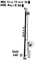
| A81-APT | ACTVT REILS RWY 18 & 36; MIRL RWY 18/36 - CTAF. VASI RWY 18 & 36 ON CONSLY. |
| A81-BCN | 24 HR. |
Runways
Runway Summary
| Runways: | 18/36 |
| Longest Runway: | 18/36 is 4359 ft (1329 m) long |
| Runways with an Instrument Approach: |
SIV Airport Runway Details
| Runway 18/36 | 4359 ft x 75 ft (1329 m x 23 m) | |
| Runway Length Source: | 3RD PARTY SURVEY as of 12/05/2009 | |
| Surface: | Asphalt - Good condition - Rubberized friction seal coat | |
| Runway Edge Lights: | Medium Intensity | |
Runway Weight Bearing Capacity (in thousands of pounds) |
||
| Single Wheel Landing Gear: | 27.0 | |
| Dual Wheel Landing Gear: | 35.0 | |
Runway 18 |
Runway 36 |
|
Elevation: |
536.9 | 534.6 |
Latitude: |
39-07-14.5034N | 39-06-31.4244N |
Longitude: |
087-26-53.6616W | 087-26-54.3224W |
|
Runway True Alignment: |
181 | 001 |
Glide Path Angle: |
3.0 degrees | 3.0 degrees |
Traffic Pattern: |
Left | Left |
Runway Markings Type: |
Nonprecision Instrument | Nonprecision Instrument |
Runway Markings Condition: |
Good | Good |
Object at End: |
CROPS | CROPS |
Object Height: |
10 | 10 |
Distance from End: |
380 | 380 |
Object Centerline Offset: |
0 ft. left and right of centerline | 0 ft. left and right of centerline |
Visual Glide Slope Indicators: |
2-Box VASI On Left Side Of Runway | 2-Box VASI On Left Side Of Runway |
REIL: |
Yes | Yes |
Touchdown Lights: |
No | No |
Centerline Lights: |
No | No |
Threshold Crossing Height: |
21 | 21 |
Services
Airframe Repair: |
Major |
Powerplant Repair: |
Major |
Bottled Oxygen: |
None |
Bulk Oxygen: |
None |
Fuel Available: |
100LL, Jet A |
Landing Fees: |
No |
Parking: |
Hangars and tiedowns available |
Maps & Diagrams
SIV Sectional
Flight Planning
at skyvector.com
at skyvector.com