Location
Latitude: |
44-29-04.6810N (44.484634) |
Longitude: |
088-07-46.9680W (-88.129713) |
Elevation: |
695.1 feet MSL (212 m MSL) |
Magnetic Variation: |
4.1 W (as of April 2024 from WMM2020 model) |
Time Zone: |
UTC -6.0 (Standard Time) UTC -5.0 (Daylight Savings Time) |
From City: |
07 N.M. SW of Green Bay, Wisconsin |
Found On: |
Green Bay Chart |
FAA Region: |
AGL |
Contacts
Manager: |
Publicly owned: |
| MARTY PIETTE 2077 AIRPORT DRIVE GREEN BAY, WI 54313-5596 920-498-4800 |
BROWN COUNTY 2077 AIRPORT DRIVE, STE #18 GREEN BAY, WI 54313-5596 920-498-4800 |
Operations
Airport Status: |
Operational |
Facility Use: |
Public |
Type: |
Airport |
Activation Date: |
12/1948 |
Control tower: |
Yes |
Attendance (Months/Days/Hours): |
Months/Days/Hours ALL/ALL/0500-2200 |
Boundary ARTCC: |
ZMP (Minneapolis) |
Responsible ARTCC: |
ZMP (Minneapolis) |
Lighting Schedule: |
SEE RMK |
Segmented Circle Indicator: |
No |
Traffic Pattern Altitude (MSL): |
1695 feet (517 m) |
NOTAMs Facility: |
GRB |
NOTAM-D Service: |
Yes |
International Airport of Entry: |
No |
Customs Landing Rights: |
Yes |
Military Landing Rights: |
Yes |
Civil/Military Joint Use: |
No |
Aircraft Rescue and Firefighting: |
Class I ARFF Index: C Air Carrier Service: Scheduled Certification Date: 05/1973 |
Based Aircraft
| Single Engine: | 49 |
| Multi Engine: | 28 |
| Jet Engine: | 21 |
| GA Helicopters: | 2 |
| Ultralights: | 1 |
Annual Operations (as of 12/31/2022)
| Total Operations: | 35808 | |
| Commercial: | 5564 | 15.5% |
| Air Taxi: | 8376 | 23.4% |
| GA Local: | 3994 | 11.2% |
| GA Itinerant: | 17196 | 48.0% |
| Military Aircraft: | 678 | 1.9% |
Communications
| CTAF: | 118.700 |
| Tower: | GREEN BAY 118.7 257.8 Hrs: 0530-2330 |
| Clearance Del.: | 121.75 |
| Ground: | 121.9 |
| Approach: | GREEN BAY 119.4 338.2 Hrs: 0530-2330 MINNEAPOLIS ARTCC Hrs: HOURS GREEN BAY APCH CLSD. |
| Departure: | GREEN BAY 119.4 338.2 Hrs: 0530-2330 MINNEAPOLIS ARTCC Hrs: HOURS GREEN BAY APCH CLSD. |
| ATIS: | 124.1 Hrs: 24 |
| ASOS: | (920-494-7140) |
| CLASS C: | 119.4 |
| CLASS C: | 338.2 |
| EMERG: | 121.5 |
| EMERG: | 243.0 |
- APCH/DEP SVC PRVDD BY MINNEAPOLIS ARTCC ON 125.55/370.9 (GREEN BAY RCAG) WHEN GREEN BAY APCH CLSD.
Fixed Based Operators (FBOs) & Fuel
(Click on a business for detail)
Please help us keep this information up to date. This is a FREE SERVICE just like everything else on Airport Guide! If you see that a business needs to be added, modified, or deleted please fill out our Update Form.
To add, modify, or delete a business click here.
Please help us keep this information up to date. This is a FREE SERVICE just like everything else on Airport Guide! If you see that a business needs to be added, modified, or deleted please fill out our Update Form.
Area Code: 920 |
| Business Name | Frequency | Phone | Fuel Grade |
|---|---|---|---|
| Executive Air
Update FBO info |
Unicom 123.3 | 498-4880 | 100LL, Jet A |
| Midwest Aviation
Update FBO info |
498-2722 | ||
| Titletown Jet Centre
Update FBO info |
Unicom 122.95 | 494-2669 | 100LL, Jet A |
Flight Service Stations
| Primary | Alternate | |
| FSS on Field: | N | |
| FSS Name (ID): | Green Bay(GRB) | |
| Frequency: | ||
| Toll Free Phone: | 1-800-WX-BRIEF |
Instrument Procedures / Charts
FAA Terminal Procedures valid from 0901Z 03/21/24 to 0901Z 04/18/24.
There are various types of charts available for an airport. They are listed in the Page Type column. Here is a legend for those types:
APD - Airport Diagram
DP - Departure Procedure Charts
HOT - Hot Spots
IAP - Instrument Approach Procedure Charts
MIN - Minimums
STAR - Standard Terminal Arrival Charts
| Page Type | Page Name | Volume | Action Since Last Cycle |
|---|---|---|---|
| APD | AIRPORT DIAGRAM | EC-3 | |
| IAP | ILS OR LOC RWY 06 | EC-3 | |
| IAP | ILS OR LOC RWY 36 | EC-3 | |
| IAP | LOC BC RWY 24 | EC-3 | |
| IAP | RNAV (GPS) RWY 06 | EC-3 | |
| IAP | RNAV (GPS) RWY 18 | EC-3 | |
| IAP | RNAV (GPS) RWY 24 | EC-3 | |
| IAP | RNAV (GPS) RWY 36 | EC-3 | |
| IAP | VOR-A | EC-3 | |
| LAH | LAHSO | EC-3 | |
| MIN | ALTERNATE MINIMUMS | EC-3 | |
| MIN | RADAR MINIMUMS | EC-3 | |
| MIN | TAKEOFF MINIMUMS | EC-3 |
Terminal Procedures are only available for airports in several countries with more being added all the time. If you are looking for a specific country's charts, please send an email to support(at)airportguide.com stating the country name. This will be used to prioritize the implementation.
Navigation Aids (Navaids) near GRB
| Dist (NM) | ID | Morse Code | Name | Type | Freq | True Hdg | Mag Hdg |
|---|---|---|---|---|---|---|---|
| 5.1 | GRB | _ _ . . _ . _ . . . | Green Bay | VORTAC | 115.50 | 326 | 330 |
| 5.2 | SG | . . . _ _ . | Depre | NDB | 332 | 181 | 185 |
| 5.4 | GR | _ _ . . _ . | Famis | NDB | 356 | 240 | 244 |
| 19.8 | AQ | . _ _ _ . _ | Kooky | NDB | 407 | 215 | 219 |
| 25.1 | MT | _ _ _ | Mawoc | NDB | 362 | 132 | 136 |
| 25.2 | OCQ | _ _ _ _ . _ . _ _ . _ | Oconto | NDB | 388 | 21 | 25 |
| 27.0 | CLI | _ . _ . . _ . . . . | Clintonville | NDB | 209 | 287 | 291 |
| 27.5 | AT | . _ _ | Gamie | NDB | 230 | 225 | 229 |
| 28.8 | MTW | _ _ _ . _ _ | Manitowoc | DME | 111 | 137 | 141 |
| 34.9 | OSH | _ _ _ . . . . . . . | Oshkosh | VORTAC | 116.75 | 211 | 215 |
| 36.8 | SUE | . . . . . _ . | Sturgeon Bay | NDB | 414 | 54 | 58 |
| 39.2 | PCZ | . _ _ . _ . _ . _ _ . . | Waupaca | NDB | 382 | 257 | 261 |
| 39.2 | TN | _ _ . | Tribe | NDB | 239 | 27 | 31 |
| 41.0 | OS | _ _ _ . . . | Pober | NDB | 395 | 206 | 210 |
| 44.6 | FAH | . . _ . . _ . . . . | Falls | DME | 110 | 164 | 168 |
| 46.5 | MNM | _ _ _ . _ _ | Menominee | DME | 109.6 | 26 | 30 |
| 58.2 | AIG | . _ . . _ _ . | Antigo | NDB | 347 | 314 | 318 |
| 60.0 | STE | . . . _ . | Stevens Point | VORTAC | 110.60 | 273 | 277 |
| 63.8 | BJB | _ . . . . _ _ _ _ . . . | West Bend | VOR | 109.80 | 179 | 183 |
| 65.9 | AUW | . _ . . _ . _ _ | Wausau | VOR-DME | 111.60 | 289 | 293 |
Nearby Airports with Fuel
Notices to Airmen (NOTAMS)
Remarks
| A110-10 | BIRDS ON & INVOF ARPT. |
| A110-11 | TWY D BTN TWY H AND APCH END RWY 24 CLSD TO ACFT WINGSPAN MORE THAN 118 FT. |
| A110-2 | REQUEST VOLUNTARY COMPLIANCE IN AVOIDING NOISE SENSITIVE AREAS NORTH & EAST OF ARPT BETWEEN MIDNIGHT & 6 A.M. |
| A110-3 | TWY C NOT AVBL FOR ACR WITH MORE THAN 30 PAX SEATS. |
| A110-5 | TWY D WBND NO TURN ONTO TWY J. |
| A110-6 | TWY J SWB NO TURN ONTO NBND TWY M. |
| A110-7 | TWY M SBND NO TURN ONTO TWY J. |
| A110-8 | TWY J SWB NO TURN ONTO EB TWY D. |
| A110-9 | WHEN ATC CLSD FOR CD IF UNA TO CTC ON FSS FREQ, CTC MINNEAPOLIS ARTCC AT 651-463-5588. |
| A57-18 | APCH RATIO 50:1 TO THE DSPLCD THLD. |
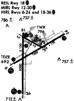
| A81-APT | ACTVT MALSR RWY 06 & 36; REIL RWY 18; HIRL RWY 06/24 & 18/36 - CTAF. PAPI RWY 06, 18, 24 & 36 OPR CONS. WHEN ATCT CLSD PREFERRED RWY PRESET ON LOW OR MED INTST; INCR INTST - CTAF. |
Runways
Runway Summary
| Runways: | 06/24 18/36 |
| Longest Runway: | 18/36 is 8700 ft (2652 m) long |
| Runways with an Instrument Approach: | 06, 36 |
GRB Airport Runway Details
| Runway 06/24 | 7700 ft x 150 ft (2347 m x 46 m) | |
| Runway Length Source: | 3RD PARTY SURVEY as of 01/26/2018 | |
| Surface: | Concrete - Good condition - Saw-cut or plastic grooved | |
| Runway Pavement Class: | 58 /R/D/W/T | |
| Runway Edge Lights: | High Intensity | |
Runway Weight Bearing Capacity (in thousands of pounds) |
||
| Single Wheel Landing Gear: | 90.0 | |
| Dual Wheel Landing Gear: | 160.0 | |
| Dual Tandem Wheel Landing Gear: | 260.0 | |
Runway 06 |
Runway 24 |
|
Elevation: |
692.0 | 681.6 |
Latitude: |
44-28-56.8001N | 44-29-34.9063N |
Longitude: |
088-08-16.9675W | 088-06-45.0604W |
|
Runway True Alignment: |
060 | 240 |
ILS Type: |
ILS/DME | |
Glide Path Angle: |
3.0 degrees | 3.0 degrees |
Traffic Pattern: |
Left | Left |
Runway Markings Type: |
Precision Instrument | Precision Instrument |
Runway Markings Condition: |
Good | Good |
Visual Glide Slope Indicators: |
4-Light PAPI On Left Side Of Runway | 4-Light PAPI On Left Side Of Runway |
Runway Visual Range (RVR): |
Touchdown | Rollout |
Approach Light System: |
1,400 Foot Medium Intensity Approach Lighting System With Runway Alignment Indicator Lights | |
REIL: |
No | No |
Touchdown Lights: |
No | No |
Centerline Lights: |
No | No |
Threshold Crossing Height: |
40 | 50 |
Declared Distances |
||
Take Off Run Avbl. (TORA): |
7699 | 7699 |
Take Off Distance Avbl. (TODA): |
7699 | 7699 |
Actual Stop Dist. Avbl. (ASDA): |
7699 | 7699 |
Landing Dist. Avbl. (LDA): |
7699 | 7699 |
| Runway 18/36 | 8700 ft x 150 ft (2652 m x 46 m) | |
| Runway Length Source: | 3RD PARTY SURVEY as of 01/26/2018 | |
| Surface: | Concrete - Good condition - Saw-cut or plastic grooved | |
| Runway Pavement Class: | 57 /R/D/W/T | |
| Runway Edge Lights: | High Intensity | |
Runway Weight Bearing Capacity (in thousands of pounds) |
||
| Single Wheel Landing Gear: | 95.0 | |
| Dual Wheel Landing Gear: | 165.0 | |
| Dual Tandem Wheel Landing Gear: | 275.0 | |
Runway 18 |
Runway 36 |
|
Elevation: |
695.0 | 684.2 |
Latitude: |
44-29-37.7420N | 44-28-11.8367N |
Longitude: |
088-08-01.1616W | 088-08-01.0028W |
|
Runway True Alignment: |
180 | 360 |
ILS Type: |
ILS | |
Glide Path Angle: |
3.0 degrees | 3.0 degrees |
Traffic Pattern: |
Right | Left |
Runway Markings Type: |
Precision Instrument | Precision Instrument |
Runway Markings Condition: |
Good | Good |
Object at End: |
ROAD | |
Object Height: |
12 | |
Distance from End: |
580 | |
Visual Glide Slope Indicators: |
4-Light PAPI On Right Side Of Runway | 4-Light PAPI On Left Side Of Runway |
Runway Visual Range (RVR): |
Rollout | Touchdown |
Approach Light System: |
1,400 Foot Medium Intensity Approach Lighting System With Runway Alignment Indicator Lights | |
REIL: |
Yes | No |
Touchdown Lights: |
No | No |
Centerline Lights: |
No | No |
Threshold Crossing Height: |
54 | 50 |
Threshold Elevation: |
694.5 | |
Displaced Threshold: |
499 | |
Threshold Latitude: |
44-29-32.8129N | |
Threshold Longitude: |
088-08-01.1532W | |
Declared Distances |
||
Take Off Run Avbl. (TORA): |
8700 | 8201 |
Take Off Distance Avbl. (TODA): |
8700 | 8201 |
Actual Stop Dist. Avbl. (ASDA): |
8700 | 8201 |
Landing Dist. Avbl. (LDA): |
8201 | 8201 |
Services
Airframe Repair: |
None |
Powerplant Repair: |
None |
Bottled Oxygen: |
None |
Bulk Oxygen: |
None |
Fuel Available: |
100LL, Jet A |
Landing Fees: |
No |
Parking: |
Hangars and tiedowns available |
Maps & Diagrams
GRB Sectional
Flight Planning
at skyvector.com
at skyvector.com