Location
Latitude: |
43-46-11.2000N (43.769778) |
Longitude: |
087-51-06.2000W (-87.851722) |
Elevation: |
755.2 feet MSL (230 m MSL) |
Magnetic Variation: |
4.2 W (as of April 2024 from WMM2020 model) |
Time Zone: |
UTC -6.0 (Standard Time) UTC -5.0 (Daylight Savings Time) |
From City: |
03 N.M. NW of Sheboygan, Wisconsin |
Found On: |
Chicago Chart |
FAA Region: |
AGL |
Contacts
Manager: |
Publicly owned: |
| MATTHEW GRENOBLE N6193 RESOURCE DR. SHEBOYGAN FALLS, WI 53085 920-467-2978 |
SHEBOYGAN COUNTY N6193 RESOURCE DRIVE SHEBOYGAN FALLS, WI 53085 920-467-2978 |
Operations
Airport Status: |
Operational |
Facility Use: |
Public |
Type: |
Airport |
Activation Date: |
10/1946 |
Control tower: |
No |
Attendance (Months/Days/Hours): |
Months/Days/Hours ALL/ALL/DAWN-DUSK |
Boundary ARTCC: |
ZAU (Chicago) |
Responsible ARTCC: |
ZAU (Chicago) |
Lighting Schedule: |
SEE RMK |
Segmented Circle Indicator: |
Yes |
Traffic Pattern Altitude (MSL): |
1755 feet (535 m) |
NOTAMs Facility: |
SBM |
NOTAM-D Service: |
Yes |
International Airport of Entry: |
No |
Customs Landing Rights: |
No |
Military Landing Rights: |
Yes |
Civil/Military Joint Use: |
No |
Based Aircraft
| Single Engine: | 52 |
| Multi Engine: | 7 |
| Jet Engine: | 6 |
Annual Operations (as of 06/15/2023)
| Total Operations: | 22600 | |
| Air Taxi: | 2500 | 11.1% |
| GA Local: | 10000 | 44.2% |
| GA Itinerant: | 10000 | 44.2% |
| Military Aircraft: | 100 | 0.4% |
Communications
| CTAF: | 122.700 |
| Unicom: | 122.700 |
| Approach: | MILWAUKEE 127.375 127.375 127.375 |
| Departure: | MILWAUKEE 127.375 127.375 127.375 |
| ASOS: | 118.425 (920-467-0744) |
- CLNC DEL SVC PRVDD BY MILWAUKEE ATCT ON FREQ 127.375
- APCH/DEP SVC PRVDD BY MILWAUKEE ATCT ON FREQ 127.375/263.075.
Fixed Based Operators (FBOs) & Fuel
(Click on a business for detail)
Please help us keep this information up to date. This is a FREE SERVICE just like everything else on Airport Guide! If you see that a business needs to be added, modified, or deleted please fill out our Update Form.
To add, modify, or delete a business click here.
Please help us keep this information up to date. This is a FREE SERVICE just like everything else on Airport Guide! If you see that a business needs to be added, modified, or deleted please fill out our Update Form.
Area Code: 920 |
| Business Name | Frequency | Phone | Fuel Grade |
|---|---|---|---|
| Magnus Aviation, Inc.
Update FBO info |
467-6151, 800-242-7643 | 100LL, Jet A |
Flight Service Stations
| Primary | Alternate | |
| FSS on Field: | N | |
| FSS Name (ID): | Green Bay(GRB) | |
| Frequency: | ||
| Toll Free Phone: | 1-800-WX-BRIEF |
Instrument Procedures / Charts
FAA Terminal Procedures valid from 0901Z 03/21/24 to 0901Z 04/18/24.
There are various types of charts available for an airport. They are listed in the Page Type column. Here is a legend for those types:
APD - Airport Diagram
DP - Departure Procedure Charts
HOT - Hot Spots
IAP - Instrument Approach Procedure Charts
MIN - Minimums
STAR - Standard Terminal Arrival Charts
| Page Type | Page Name | Volume | Action Since Last Cycle |
|---|---|---|---|
| APD | AIRPORT DIAGRAM | EC-3 | |
| IAP | ILS OR LOC RWY 22 | EC-3 | |
| IAP | RNAV (GPS) RWY 04 | EC-3 | |
| IAP | RNAV (GPS) RWY 13 | EC-3 | |
| IAP | RNAV (GPS) RWY 22 | EC-3 | |
| IAP | RNAV (GPS) RWY 31 | EC-3 | |
| MIN | ALTERNATE MINIMUMS | EC-3 | |
| MIN | TAKEOFF MINIMUMS | EC-3 |
Terminal Procedures are only available for airports in several countries with more being added all the time. If you are looking for a specific country's charts, please send an email to support(at)airportguide.com stating the country name. This will be used to prioritize the implementation.
Navigation Aids (Navaids) near SBM
| Dist (NM) | ID | Morse Code | Name | Type | Freq | True Hdg | Mag Hdg |
|---|---|---|---|---|---|---|---|
| 0.1 | FAH | . . _ . . _ . . . . | Falls | DME | 110 | 114 | 118 |
| 22.8 | MTW | _ _ _ . _ _ | Manitowoc | DME | 111 | 18 | 22 |
| 24.0 | BJB | _ . . . . _ _ _ _ . . . | West Bend | VOR | 109.80 | 209 | 213 |
| 26.6 | MT | _ _ _ | Mawoc | NDB | 362 | 13 | 17 |
| 31.2 | OS | _ _ _ . . . | Pober | NDB | 395 | 281 | 285 |
| 33.2 | OSH | _ _ _ . . . . . . . | Oshkosh | VORTAC | 116.75 | 293 | 297 |
| 35.7 | AQ | . _ _ _ . _ | Kooky | NDB | 407 | 318 | 322 |
| 39.5 | AT | . _ _ | Gamie | NDB | 230 | 306 | 310 |
| 39.6 | SG | . . . _ _ . | Depre | NDB | 332 | 342 | 346 |
| 40.4 | LJT | . _ . . . _ _ _ _ | Timmerman | DME | 115.65 | 191 | 195 |
| 42.2 | UNU | . . _ _ . . . _ | Juneau | NDB | 344 | 241 | 245 |
| 42.6 | BL | _ . . . . _ . . | Yanks | NDB | 260 | 181 | 185 |
| 43.5 | BAE | _ . . . . _ . | Badger | VOR-DME | 116.40 | 205 | 209 |
| 43.6 | GR | _ _ . . _ . | Famis | NDB | 356 | 337 | 341 |
| 49.3 | MKE | _ _ _ . _ . | Milwaukee | VOT | 109.00 | 182 | 186 |
| 49.4 | GRB | _ _ . . _ . _ . . . | Green Bay | VORTAC | 115.50 | 342 | 346 |
| 52.2 | RYV | . _ . _ . _ _ . . . _ | Rock River | NDB | 371 | 227 | 231 |
| 52.3 | GM | _ _ . _ _ | Teels | NDB | 242 | 189 | 193 |
| 60.5 | HRK | . . . . . _ . _ . _ | Horlick | DME | 114.05 | 178 | 182 |
| 60.7 | PCZ | . _ _ . _ . _ . _ _ . . | Waupaca | NDB | 382 | 304 | 308 |
Nearby Airports with Fuel
Notices to Airmen (NOTAMS)
Remarks
| A110-2 | ULTRALIGHT ACTVTY ON & IN VCNTY OF ARPT. |
| A110-3 | WATERFOWL & DEER ON & INVOF ARPT. |
| A110-5 | GCO AVBL ON FREQ 121.725 THRU FLT SVCS. |
| A110-6 | US CUST AND BDR PROTECTION, PPR US CSTMS SVC MON-FRI 1100 - 1900 CALL 920-335-2225. |
| A43-31 | UNUSBL BYD 4 DEGS RIGHT OF CNTRLN. |
| A70-FUEL-10 | 0LL 24 HR FUEL AVBL WITH CREDIT CARD. |
| A81-APT | ACTVT MALSR RWY 22; REIL RWY 04; PAPI RWY 04 & 22 - CTAF. HIRL RWY 04/22 & MIRL RWY 13/31 PRESET TO LOW SS-SR; TO INCR INTST & ACTVT - CTAF. PAPI RWY 13 & 31 OPRS CONSLY. |
| E80 | US CUSTOMS USER FEE ARPT. |
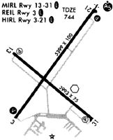
Runways
Runway Summary
| Runways: | 04/22 13/31 |
| Longest Runway: | 04/22 is 6800 ft (2073 m) long |
| Runways with an Instrument Approach: | 22 |
SBM Airport Runway Details
| Runway 04/22 | 6800 ft x 100 ft (2073 m x 30 m) | |
| Runway Length Source: | 3RD PARTY SURVEY as of 11/13/2011 | |
| Surface: | Concrete - Good condition - Saw-cut or plastic grooved | |
| Runway Edge Lights: | High Intensity | |
Runway Weight Bearing Capacity (in thousands of pounds) |
||
| Single Wheel Landing Gear: | 45.0 | |
| Dual Wheel Landing Gear: | 98.0 | |
Runway 04 |
Runway 22 |
|
Elevation: |
743.9 | 742.7 |
Latitude: |
43-45-47.4137N | 43-46-42.3194N |
Longitude: |
087-51-31.3602W | 087-50-37.9950W |
|
Runway True Alignment: |
035 | 215 |
ILS Type: |
ILS/DME | |
Glide Path Angle: |
3.0 degrees | 3.0 degrees |
Traffic Pattern: |
Left | Left |
Runway Markings Type: |
Precision Instrument | Precision Instrument |
Runway Markings Condition: |
Fair | Fair |
Visual Glide Slope Indicators: |
4-Light PAPI On Left Side Of Runway | 4-Light PAPI On Left Side Of Runway |
Approach Light System: |
1,400 Foot Medium Intensity Approach Lighting System With Runway Alignment Indicator Lights | |
REIL: |
Yes | |
Threshold Crossing Height: |
52 | 49 |
| Runway 13/31 | 5002 ft x 75 ft (1525 m x 23 m) | |
| Runway Length Source: | 3RD PARTY SURVEY as of 11/13/2011 | |
| Surface: | Concrete - Good condition - No special surface treatment | |
| Runway Edge Lights: | Medium Intensity | |
Runway Weight Bearing Capacity (in thousands of pounds) |
||
| Single Wheel Landing Gear: | 30.0 | |
| Dual Wheel Landing Gear: | 72.0 | |
Runway 13 |
Runway 31 |
|
Elevation: |
755.2 | 739.7 |
Latitude: |
43-46-21.8232N | 43-45-50.4657N |
Longitude: |
087-51-34.6011W | 087-50-41.9368W |
|
Runway True Alignment: |
130 | 310 |
Glide Path Angle: |
3.0 degrees | 3.0 degrees |
Traffic Pattern: |
Left | Left |
Runway Markings Type: |
Nonprecision Instrument | Nonprecision Instrument |
Runway Markings Condition: |
Fair | Fair |
Object at End: |
TREES | TREES |
Object Height: |
56 | 57 |
Distance from End: |
1680 | 1800 |
Visual Glide Slope Indicators: |
4-Light PAPI On Left Side Of Runway | 4-Light PAPI On Left Side Of Runway |
Threshold Crossing Height: |
34 | 40 |
Services
Airframe Repair: |
None |
Powerplant Repair: |
None |
Fuel Available: |
100LL, Jet A+ |
Landing Fees: |
No |
Parking: |
Hangars and tiedowns available |
Maps & Diagrams
SBM Sectional
Flight Planning
at skyvector.com
at skyvector.com