Location
Latitude: |
43-25-35.3000N (43.426472) |
Longitude: |
088-42-13.9000W (-88.703861) |
Elevation: |
934.1 feet MSL (285 m MSL) |
Magnetic Variation: |
3.5 W (as of April 2024 from WMM2020 model) |
Time Zone: |
UTC -6.0 (Standard Time) UTC -5.0 (Daylight Savings Time) |
From City: |
02 N.M. N of Juneau, Wisconsin |
Found On: |
Chicago Chart |
FAA Region: |
AGL |
Contacts
Manager: |
Publicly owned: |
| TOM DAVID W6491 STATE HIGHWAY 26 JUNEAU, WI 53039 920-386-2402 |
DODGE COUNTY DODGE CO HWY DEPT JUNEAU, WI 53039 920-386-3650 |
Operations
Airport Status: |
Operational |
Facility Use: |
Public |
Type: |
Airport |
Activation Date: |
07/1979 |
Control tower: |
No |
Attendance (Months/Days/Hours): |
Months/Days/Hours ALL/ALL/0700-2000 |
Boundary ARTCC: |
ZAU (Chicago) |
Responsible ARTCC: |
ZAU (Chicago) |
Lighting Schedule: |
SEE RMK |
Segmented Circle Indicator: |
Yes |
Traffic Pattern Altitude (MSL): |
1934 feet (589 m) |
NOTAMs Facility: |
UNU |
NOTAM-D Service: |
Yes |
International Airport of Entry: |
No |
Customs Landing Rights: |
No |
Civil/Military Joint Use: |
No |
Based Aircraft
| Single Engine: | 45 |
| Multi Engine: | 4 |
| Jet Engine: | 1 |
Annual Operations (as of 05/24/2021)
| Total Operations: | 29000 | |
| Air Taxi: | 1000 | 3.4% |
| GA Local: | 15000 | 51.7% |
| GA Itinerant: | 12000 | 41.4% |
| Military Aircraft: | 1000 | 3.4% |
Communications
| CTAF: | 122.700 |
| Unicom: | 122.700 |
| Approach: | MADISON 119.15 119.15 CHICAGO ARTCC |
| Departure: | MADISON 119.15 119.15 CHICAGO ARTCC |
| AWOS-3: | 120.825 (920-386-5682) |
- APCH/DEP SVC PRVDD BY CHICAGO ARTCC ON FREQS 133.3/257.925 (LONE ROCK RCAG) WHEN MADISON APCH CTL CLSD.
Fixed Based Operators (FBOs) & Fuel
(Click on a business for detail)
Please help us keep this information up to date. This is a FREE SERVICE just like everything else on Airport Guide! If you see that a business needs to be added, modified, or deleted please fill out our Update Form.
To add, modify, or delete a business click here.
Please help us keep this information up to date. This is a FREE SERVICE just like everything else on Airport Guide! If you see that a business needs to be added, modified, or deleted please fill out our Update Form.
Area Code: 920 |
| Business Name | Frequency | Phone | Fuel Grade |
|---|---|---|---|
| Beaver Aviation, Inc.
Update FBO info |
386-2636 | ||
| Wisconsin Aviation-Dodge County
Update FBO info |
Unicom 122.7 | 386-2402 | 100LL, Jet A |
Flight Service Stations
| Primary | Alternate | |
| FSS on Field: | N | |
| FSS Name (ID): | Green Bay(GRB) | |
| Frequency: | ||
| Toll Free Phone: | 1-800-WX-BRIEF |
Instrument Procedures / Charts
FAA Terminal Procedures valid from 0901Z 03/21/24 to 0901Z 04/18/24.
There are various types of charts available for an airport. They are listed in the Page Type column. Here is a legend for those types:
APD - Airport Diagram
DP - Departure Procedure Charts
HOT - Hot Spots
IAP - Instrument Approach Procedure Charts
MIN - Minimums
STAR - Standard Terminal Arrival Charts
| Page Type | Page Name | Volume | Action Since Last Cycle |
|---|---|---|---|
| IAP | RNAV (GPS) RWY 02 | EC-3 | |
| IAP | RNAV (GPS) RWY 08 | EC-3 | |
| IAP | RNAV (GPS) RWY 20 | EC-3 | |
| IAP | RNAV (GPS) RWY 26 | EC-3 | |
| MIN | ALTERNATE MINIMUMS | EC-3 | |
| MIN | TAKEOFF MINIMUMS | EC-3 |
Terminal Procedures are only available for airports in several countries with more being added all the time. If you are looking for a specific country's charts, please send an email to support(at)airportguide.com stating the country name. This will be used to prioritize the implementation.
Navigation Aids (Navaids) near UNU
| Dist (NM) | ID | Morse Code | Name | Type | Freq | True Hdg | Mag Hdg |
|---|---|---|---|---|---|---|---|
| 0.2 | UNU | . . _ _ . . . _ | Juneau | NDB | 344 | 25 | 29 |
| 15.2 | RYV | . _ . _ . _ _ . . . _ | Rock River | NDB | 371 | 183 | 187 |
| 25.2 | BJB | _ . . . . _ _ _ _ . . . | West Bend | VOR | 109.80 | 90 | 94 |
| 26.1 | BAE | _ . . . . _ . | Badger | VOR-DME | 116.40 | 135 | 139 |
| 27.6 | OS | _ _ _ . . . | Pober | NDB | 395 | 13 | 17 |
| 32.5 | MSN | _ _ . . . _ . | Madison | VORTAC | 108.60 | 238 | 241 |
| 34.4 | OSH | _ _ _ . . . . . . . | Oshkosh | VORTAC | 116.75 | 10 | 14 |
| 34.8 | LJT | . _ . . . _ _ _ _ | Timmerman | DME | 115.65 | 122 | 126 |
| 35.5 | MS | _ _ . . . | Monah | NDB | 400 | 232 | 235 |
| 42.3 | BL | _ . . . . _ . . | Yanks | NDB | 260 | 121 | 125 |
| 42.5 | FAH | . . _ . . _ . . . . | Falls | DME | 110 | 60 | 64 |
| 42.5 | GM | _ _ . _ _ | Teels | NDB | 242 | 136 | 140 |
| 43.9 | LVV | . _ . . . . . _ . . . _ | Lake Lawn | NDB | 404 | 173 | 177 |
| 44.5 | AT | . _ _ | Gamie | NDB | 230 | 6 | 10 |
| 45.5 | MKE | _ _ _ . _ . | Milwaukee | VOT | 109.00 | 128 | 132 |
| 46.7 | DLL | _ . . . _ . . . _ . . | Dells | VORTAC | 117.00 | 279 | 282 |
| 47.6 | BUU | _ . . . . . _ . . _ | Burbun | DME | 114.5 | 158 | 162 |
| 49.2 | AQ | . _ _ _ . _ | Kooky | NDB | 407 | 15 | 19 |
| 50.9 | JVL | . _ _ _ . . . _ . _ . . | Janesville | NDB | 375 | 197 | 200 |
| 55.0 | JVL | . _ _ _ . . . _ . _ . . | Janesville | VOR-DME | 114.30 | 198 | 201 |
Nearby Airports with Fuel
Notices to Airmen (NOTAMS)
Remarks
| A110-1 | IREG ULTRALIGHT ACTIVITY ON & INVOF ARPT. |
| A110-4 | BIRDS ON & INVOF ARPT. |
| A110-6 | MOWING OPNS MON-FRI WITH FLASHING LGTS AFT DARK. |
| A110-7 | FOR CD CTC MADISON APP/DEP CON AT 608-249-8240. WHEN MADISON APCH CLSD, FOR CD CTC CHICAGO ARTCC AT 630-906-8921. |
| A81-APT | MIRL RWY 08/26 PRESET ON LOW INTST; TO INCR INTST AND ACTVT MALSF RWY 26; REIL RWY 02, 08, & 20; PAPI RWY 02, 08, 20, & 26; MIRL RWY 02/20; MIRL RWY 08/26 - CTAF. |
Runways
Runway Summary
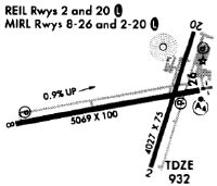
| Runways: | 02/20 08/26 |
| Longest Runway: | 08/26 is 5070 ft (1545 m) long |
| Runways with an Instrument Approach: | 26 |
UNU Airport Runway Details
| Runway 02/20 | 4028 ft x 75 ft (1228 m x 23 m) | |
| Runway Length Source: | 3RD PARTY SURVEY as of 11/05/2011 | |
| Surface: | Asphalt - Fair condition - No special surface treatment | |
| Runway Edge Lights: | Medium Intensity | |
Runway Weight Bearing Capacity (in thousands of pounds) |
||
| Single Wheel Landing Gear: | 12.5 | |
Runway 02 |
Runway 20 |
|
Elevation: |
930.3 | 932.2 |
Latitude: |
43-25-17.7649N | 43-25-55.7654N |
Longitude: |
088-42-06.7391W | 088-41-50.5970W |
|
Runway True Alignment: |
017 | 197 |
Glide Path Angle: |
3.0 degrees | 3.0 degrees |
Traffic Pattern: |
Left | Left |
Runway Markings Type: |
Nonprecision Instrument | Nonprecision Instrument |
Runway Markings Condition: |
Fair | Fair |
Visual Glide Slope Indicators: |
2-Light PAPI On Left Side Of Runway | 2-Light PAPI On Left Side Of Runway |
REIL: |
Yes | Yes |
Threshold Crossing Height: |
26 | 25 |
| Runway 08/26 | 5070 ft x 100 ft (1545 m x 30 m) | |
| Runway Length Source: | 3RD PARTY SURVEY as of 11/05/2011 | |
| Surface: | Asphalt - Fair condition - No special surface treatment | |
| Runway Edge Lights: | Medium Intensity | |
Runway 08 |
Runway 26 |
|
Elevation: |
890.1 | 934.1 |
Latitude: |
43-25-29.7437N | 43-25-38.6777N |
Longitude: |
088-42-59.7210W | 088-41-52.1323W |
|
Runway True Alignment: |
080 | 260 |
ILS Type: |
LOC/DME | |
Glide Path Angle: |
3.0 degrees | 3.0 degrees |
Traffic Pattern: |
Left | Left |
Runway Markings Type: |
Nonprecision Instrument | Nonprecision Instrument |
Runway Markings Condition: |
Good | Good |
Object at End: |
TREES | |
Object Height: |
146 | |
Distance from End: |
4300 | |
Visual Glide Slope Indicators: |
4-Light PAPI On Left Side Of Runway | 4-Light PAPI On Left Side Of Runway |
Approach Light System: |
1,400 Foot Medium Intensity Approach Lighting System With Sequenced Flashers | |
REIL: |
Yes | |
Threshold Crossing Height: |
26 | 35 |
Services
Airframe Repair: |
None |
Powerplant Repair: |
None |
Bottled Oxygen: |
None |
Bulk Oxygen: |
None |
Fuel Available: |
100LL, Mogas |
Landing Fees: |
No |
Parking: |
Tiedowns available |
Maps & Diagrams
UNU Sectional
Flight Planning
at skyvector.com
at skyvector.com