Location
Latitude: |
44-32-42.4880N (44.545136) |
Longitude: |
089-31-49.0240W (-89.530284) |
Elevation: |
1110.0 feet MSL (338 m MSL) |
Magnetic Variation: |
3 W (as of April 2024 from WMM2020 model) |
Time Zone: |
UTC -6.0 (Standard Time) UTC -5.0 (Daylight Savings Time) |
From City: |
03 N.M. NE of Stevens Point, Wisconsin |
Found On: |
Green Bay Chart |
FAA Region: |
AGL |
Contacts
Manager: |
Publicly owned: |
| JASON DRAHEIM 4501 HWY 66 STEVENS POINT, WI 54482 715-345-8993 |
STEVENS POINT 1515 STRONGS AVE STEVENS POINT, WI 54481 715-345-8989 |
Operations
Airport Status: |
Operational |
Facility Use: |
Public |
Type: |
Airport |
Activation Date: |
02/1940 |
Control tower: |
No |
Attendance (Months/Days/Hours): |
Months/Days/Hours ALL/MON-FRI/0730-1630 |
Boundary ARTCC: |
ZMP (Minneapolis) |
Responsible ARTCC: |
ZMP (Minneapolis) |
Lighting Schedule: |
SEE RMK |
Segmented Circle Indicator: |
Yes |
Traffic Pattern Altitude (MSL): |
2110 feet (643 m) |
NOTAMs Facility: |
STE |
NOTAM-D Service: |
Yes |
International Airport of Entry: |
No |
Customs Landing Rights: |
No |
Military Landing Rights: |
Yes |
Civil/Military Joint Use: |
No |
Based Aircraft
| Single Engine: | 31 |
| Multi Engine: | 3 |
| Jet Engine: | 1 |
Annual Operations (as of 08/02/2023)
| Total Operations: | 36750 | |
| Air Taxi: | 3100 | 8.4% |
| GA Local: | 18500 | 50.3% |
| GA Itinerant: | 15000 | 40.8% |
| Military Aircraft: | 150 | 0.4% |
Communications
| CTAF: | 122.700 |
| Unicom: | 122.700 |
| AWOS-3: | 119.275 (715-344-5960) |
- APCH/DEP SVC PRVDD BY MINNEAPOLIS ARTCC ON FREQS 124.4/317.7 (MOSINEE RCAG).
Fixed Based Operators (FBOs) & Fuel
(Click on a business for detail)
Please help us keep this information up to date. This is a FREE SERVICE just like everything else on Airport Guide! If you see that a business needs to be added, modified, or deleted please fill out our Update Form.
To add, modify, or delete a business click here.
Please help us keep this information up to date. This is a FREE SERVICE just like everything else on Airport Guide! If you see that a business needs to be added, modified, or deleted please fill out our Update Form.
Area Code: 715 |
| Business Name | Frequency | Phone | Fuel Grade |
|---|---|---|---|
| Sentry Aviation Services
Update FBO info |
Unicom 122.7 | 345-8989 | 100LL, Jet A |
Flight Service Stations
| Primary | Alternate | |
| FSS on Field: | N | |
| FSS Name (ID): | Green Bay(GRB) | |
| Frequency: | ||
| Toll Free Phone: | 1-800-WX-BRIEF |
Instrument Procedures / Charts
FAA Terminal Procedures valid from 0901Z 03/21/24 to 0901Z 04/18/24.
There are various types of charts available for an airport. They are listed in the Page Type column. Here is a legend for those types:
APD - Airport Diagram
DP - Departure Procedure Charts
HOT - Hot Spots
IAP - Instrument Approach Procedure Charts
MIN - Minimums
STAR - Standard Terminal Arrival Charts
| Page Type | Page Name | Volume | Action Since Last Cycle |
|---|---|---|---|
| IAP | ILS OR LOC RWY 21 | EC-3 | Changed |
| IAP | RNAV (GPS) RWY 03 | EC-3 | Changed |
| IAP | RNAV (GPS) RWY 12 | EC-3 | |
| IAP | RNAV (GPS) RWY 21 | EC-3 | Changed |
| IAP | RNAV (GPS) RWY 30 | EC-3 | |
| MIN | ALTERNATE MINIMUMS | EC-3 | |
| MIN | TAKEOFF MINIMUMS | EC-3 |
Terminal Procedures are only available for airports in several countries with more being added all the time. If you are looking for a specific country's charts, please send an email to support(at)airportguide.com stating the country name. This will be used to prioritize the implementation.
Navigation Aids (Navaids) near STE
| Dist (NM) | ID | Morse Code | Name | Type | Freq | True Hdg | Mag Hdg |
|---|---|---|---|---|---|---|---|
| 0.1 | STE | . . . _ . | Stevens Point | VORTAC | 110.60 | 186 | 189 |
| 9.3 | PH | . _ _ . . . . . | Bayye | NDB | 351 | 327 | 330 |
| 17.1 | ISW | . . . . . . _ _ | Wisconsin Rapids | NDB | 215 | 230 | 233 |
| 18.3 | AUW | . _ . . _ . _ _ | Wausau | VOR-DME | 111.60 | 352 | 355 |
| 23.0 | EK | . _ . _ | Nepco | NDB | 326 | 221 | 224 |
| 23.3 | FZK | . . _ . _ _ . . _ . _ | Wausau | NDB | 243 | 350 | 353 |
| 25.3 | PCZ | . _ _ . _ . _ . _ _ . . | Waupaca | NDB | 382 | 119 | 122 |
| 26.6 | DU | _ . . . . _ | Calin | NDB | 266 | 273 | 276 |
| 28.7 | MFI | _ _ . . _ . . . | Marshfield | NDB | 391 | 281 | 284 |
| 34.3 | CLI | _ . _ . . _ . . . . | Clintonville | NDB | 209 | 82 | 85 |
| 39.9 | RRL | . _ . . _ . . _ . . | Merrill | NDB | 257 | 349 | 352 |
| 40.8 | AIG | . _ . . _ _ . | Antigo | NDB | 347 | 25 | 28 |
| 42.1 | VIQ | . . . _ . . _ _ . _ | Neillsville | NDB | 368 | 271 | 274 |
| 46.6 | AT | . _ _ | Gamie | NDB | 230 | 119 | 122 |
| 47.2 | MDZ | _ _ _ . . _ _ . . | Medford | NDB | 335 | 315 | 318 |
| 47.8 | VOK | . . . _ _ _ _ _ . _ | Volk | TACAN | 110.40 | 221 | 224 |
| 52.4 | AQ | . _ _ _ . _ | Kooky | NDB | 407 | 111 | 114 |
| 53.5 | OSH | _ _ _ . . . . . . . | Oshkosh | VORTAC | 116.75 | 128 | 131 |
| 55.6 | GR | _ _ . . _ . | Famis | NDB | 356 | 96 | 100 |
| 57.1 | GRB | _ _ . . _ . _ . . . | Green Bay | VORTAC | 115.50 | 88 | 92 |
Nearby Airports with Fuel
Notices to Airmen (NOTAMS)
Remarks
| A110*G | THIS AIRPORT HAS BEEN SURVEYED BY THE NATIONAL GEODETIC SURVEY. |
| A110-2 | MIGRATORY WATERFOWL ON & INVOF ARPT. |
| A110-3 | FOR CD CTC MINNEAPOLIS ARTCC AT 651-463-5588. |
| A15 | EMAIL ADDRESS: JDRAHEIM@STEVENSPOINT.COM (ALL LOWER CASE) |
| A16 | AFT HRS CALL 715-345-8989; OPTION 3. |
| A70-FUEL-10 | 0LL 24 HR SELF SVC FUEL AVBL WITH CREDIT CARD. |
| A81-APT | HIRL ON ACTV RWY PRESET TO LOW SS-SR; TO INCR INTST AND ACTVT MALS RWY 21; REIL RWY 03; PAPI RWY 03 & 21; HIRL RWY 03/21 & RWY 12/30 - CTAF. |
Runways
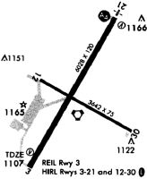
Runway Summary
| Runways: | 03/21 12/30 |
| Longest Runway: | 03/21 is 6028 ft (1837 m) long |
| Runways with an Instrument Approach: | 21 |
STE Airport Runway Details
| Runway 03/21 | 6028 ft x 120 ft (1837 m x 37 m) | |
| Runway Length Source: | 3RD PARTY SURVEY as of 09/19/2005 | |
| Surface: | Asphalt - Excellent condition - No special surface treatment | |
| Runway Edge Lights: | High Intensity | |
Runway Weight Bearing Capacity (in thousands of pounds) |
||
| Single Wheel Landing Gear: | 30.0 | |
| Dual Wheel Landing Gear: | 75.0 | |
| Dual Tandem Wheel Landing Gear: | 195.0 | |
Runway 03 |
Runway 21 |
|
Elevation: |
1104.0 | 1110.0 |
Latitude: |
44-32-18.3500N | 44-33-10.0800N |
Longitude: |
089-32-11.7700W | 089-31-30.6100W |
|
Runway True Alignment: |
030 | 210 |
ILS Type: |
ILS/DME | |
Glide Path Angle: |
3.0 degrees | 3.0 degrees |
Traffic Pattern: |
Left | Left |
Runway Markings Type: |
Nonprecision Instrument | Nonprecision Instrument |
Runway Markings Condition: |
Good | Good |
Object at End: |
TREES | TREES |
Object Height: |
40 | 16 |
Distance from End: |
1140 | 265 |
Object Centerline Offset: |
600 ft. left of centerline | 510 ft. right of centerline |
Visual Glide Slope Indicators: |
2-Light PAPI On Left Side Of Runway | 4-Light PAPI On Left Side Of Runway |
Approach Light System: |
1,400 Foot Medium Intensity Approach Lighting System | |
REIL: |
Yes | No |
Touchdown Lights: |
No | No |
Centerline Lights: |
No | No |
Threshold Crossing Height: |
44 | 45 |
| Runway 12/30 | 3635 ft x 75 ft (1108 m x 23 m) | |
| Runway Length Source: | 3RD PARTY SURVEY as of 09/19/2005 | |
| Surface: | Asphalt - Excellent condition - No special surface treatment | |
| Runway Edge Lights: | High Intensity | |
Runway Weight Bearing Capacity (in thousands of pounds) |
||
| Single Wheel Landing Gear: | 9.0 | |
| Dual Wheel Landing Gear: | 75.0 | |
Runway 12 |
Runway 30 |
|
Elevation: |
1105.0 | 1103.0 |
Latitude: |
44-32-48.4000N | 44-32-30.6400N |
Longitude: |
089-32-07.1700W | 089-31-23.5600W |
|
Runway True Alignment: |
120 | 300 |
Glide Path Angle: |
0.0 degrees | 0.0 degrees |
Traffic Pattern: |
Left | Left |
Runway Markings Type: |
Nonprecision Instrument | Nonprecision Instrument |
Runway Markings Condition: |
Good | Good |
Object at End: |
TREES | TREES |
Object Height: |
56 | 15 |
Distance from End: |
745 | 340 |
Object Centerline Offset: |
600 ft. left of centerline | 510 ft. right of centerline |
REIL: |
No | No |
Touchdown Lights: |
No | No |
Centerline Lights: |
No | No |
Services
Airframe Repair: |
Major |
Powerplant Repair: |
Major |
Bottled Oxygen: |
None |
Bulk Oxygen: |
None |
Fuel Available: |
100LL, Jet A |
Landing Fees: |
No |
Parking: |
Hangars and tiedowns available |
Maps & Diagrams
STE Sectional
Flight Planning
at skyvector.com
at skyvector.com