Location
Latitude: |
45-09-14.2189N (45.153949) |
Longitude: |
089-06-38.2203W (-89.110617) |
Elevation: |
1523.0 feet MSL (464 m MSL) |
Magnetic Variation: |
3.4 W (as of April 2024 from WMM2020 model) |
Time Zone: |
UTC -6.0 (Standard Time) UTC -5.0 (Daylight Savings Time) |
From City: |
02 N.M. NE of Antigo, Wisconsin |
Found On: |
Green Bay Chart |
FAA Region: |
AGL |
Contacts
Manager: |
Publicly owned: |
| DONALD BINTZ N3689 N LANGLADE RD ANTIGO, WI 54409 702-324-9966 |
LANGLADE COUNTY N3689 N LANGLADE RD ANTIGO, WI 54409 (715) 623-3539 |
Operations
Airport Status: |
Operational |
Facility Use: |
Public |
Type: |
Airport |
Activation Date: |
10/1944 |
Control tower: |
No |
Attendance (Months/Days/Hours): |
Months/Days/Hours ALL/MON-SAT/0800-1700 |
Boundary ARTCC: |
ZMP (Minneapolis) |
Responsible ARTCC: |
ZMP (Minneapolis) |
Lighting Schedule: |
SEE RMK |
Segmented Circle Indicator: |
No |
Traffic Pattern Altitude (MSL): |
2523 feet (769 m) |
NOTAMs Facility: |
AIG |
NOTAM-D Service: |
Yes |
International Airport of Entry: |
No |
Customs Landing Rights: |
No |
Military Landing Rights: |
Yes |
Civil/Military Joint Use: |
No |
Based Aircraft
| Single Engine: | 19 |
| Jet Engine: | 1 |
Annual Operations (as of 08/10/2023)
| Total Operations: | 8250 | |
| Air Taxi: | 200 | 2.4% |
| GA Local: | 4000 | 48.5% |
| GA Itinerant: | 4000 | 48.5% |
| Military Aircraft: | 50 | 0.6% |
Communications
| CTAF: | 122.800 |
| Unicom: | 122.800 |
| AWOS-3: | 119.075 (715-627-2869) |
- APCH/DEP SVC PRVDD BY MINNEAPOLIS ARTCC ON FREQS 124.4/317.7 (MOSINEE RCAG).
Fixed Based Operators (FBOs) & Fuel
(Click on a business for detail)
Please help us keep this information up to date. This is a FREE SERVICE just like everything else on Airport Guide! If you see that a business needs to be added, modified, or deleted please fill out our Update Form.
To add, modify, or delete a business click here.
Please help us keep this information up to date. This is a FREE SERVICE just like everything else on Airport Guide! If you see that a business needs to be added, modified, or deleted please fill out our Update Form.
Area Code: 715 |
| Business Name | Frequency | Phone | Fuel Grade |
|---|---|---|---|
| Alpha Aviation
Update FBO info |
623-4525 | 100LL, Mogas, Jet A |
Flight Service Stations
| Primary | Alternate | |
| FSS on Field: | N | |
| FSS Name (ID): | Green Bay(GRB) | |
| Frequency: | ||
| Toll Free Phone: | 1-800-WX-BRIEF |
Instrument Procedures / Charts
FAA Terminal Procedures valid from 0901Z 03/21/24 to 0901Z 04/18/24.
There are various types of charts available for an airport. They are listed in the Page Type column. Here is a legend for those types:
APD - Airport Diagram
DP - Departure Procedure Charts
HOT - Hot Spots
IAP - Instrument Approach Procedure Charts
MIN - Minimums
STAR - Standard Terminal Arrival Charts
| Page Type | Page Name | Volume | Action Since Last Cycle |
|---|---|---|---|
| IAP | RNAV (GPS) RWY 09 | EC-3 | |
| IAP | RNAV (GPS) RWY 17 | EC-3 | |
| IAP | RNAV (GPS) RWY 27 | EC-3 | |
| IAP | RNAV (GPS) RWY 35 | EC-3 | |
| MIN | ALTERNATE MINIMUMS | EC-3 | |
| MIN | TAKEOFF MINIMUMS | EC-3 |
Terminal Procedures are only available for airports in several countries with more being added all the time. If you are looking for a specific country's charts, please send an email to support(at)airportguide.com stating the country name. This will be used to prioritize the implementation.
Navigation Aids (Navaids) near KAIG
| Dist (NM) | ID | Morse Code | Name | Type | Freq | True Hdg | Mag Hdg |
|---|---|---|---|---|---|---|---|
| 0.3 | AIG | . _ . . _ _ . | Antigo | NDB | 347 | 336 | 339 |
| 25.3 | RRL | . _ . . _ . . _ . . | Merrill | NDB | 257 | 276 | 279 |
| 25.7 | FZK | . . _ . _ _ . . _ . _ | Wausau | NDB | 243 | 238 | 241 |
| 27.3 | AUW | . _ . . _ . _ _ | Wausau | VOR-DME | 111.60 | 227 | 230 |
| 32.3 | RHI | . _ . . . . . . . | Rhinelander | VOR-DME | 109.20 | 333 | 336 |
| 35.6 | RH | . _ . . . . . | Arsha | NDB | 272 | 323 | 326 |
| 35.9 | CLI | _ . _ . . _ . . . . | Clintonville | NDB | 209 | 153 | 157 |
| 36.6 | PH | . _ _ . . . . . | Bayye | NDB | 351 | 218 | 221 |
| 40.8 | STE | . . . _ . | Stevens Point | VORTAC | 110.60 | 206 | 209 |
| 48.4 | DO | _ . . _ _ _ | Dougy | NDB | 236 | 327 | 330 |
| 49.3 | PCZ | . _ _ . _ . _ . _ _ . . | Waupaca | NDB | 382 | 175 | 178 |
| 50.8 | MDZ | _ _ _ . . _ _ . . | Medford | NDB | 335 | 267 | 270 |
| 53.0 | GRB | _ _ . . _ . _ . . . | Green Bay | VORTAC | 115.50 | 132 | 136 |
| 53.1 | ARV | . _ . _ . . . . _ | Arbor Vitae | NDB | 221 | 330 | 333 |
| 53.5 | OCQ | _ _ _ _ . _ . _ _ . _ | Oconto | NDB | 388 | 107 | 111 |
| 55.2 | MFI | _ _ . . _ . . . | Marshfield | NDB | 391 | 236 | 239 |
| 56.5 | DU | _ . . . . _ | Calin | NDB | 266 | 231 | 234 |
| 56.6 | GR | _ _ . . _ . | Famis | NDB | 356 | 138 | 142 |
| 56.7 | ISW | . . . . . . _ _ | Wisconsin Rapids | NDB | 215 | 213 | 216 |
| 57.8 | IMT | . . _ _ _ | Iron Mountain | VOR-DME | 111.20 | 46 | 50 |
Nearby Airports with Fuel
Notices to Airmen (NOTAMS)
Remarks
| A110-1 | FOR CD CTC MINNEAPOLIS ARTCC AT 651-463-5588. |
| A43-35 | PAPI UNUSBL BYD 7 DEGS LEFT OF CNTRLN. |
| A81-APT | MIRL RWY 17/35 & 09/27 PRESET TO LOW SS-SR; TO INCR INTST AND ACTVT REIL RWY 17 & 35; PAPI RWY 09, 17, 27 & 35 - CTAF. |
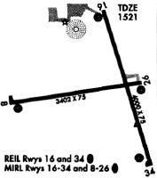
Runways
Runway Summary
| Runways: | 09/27 17/35 |
| Longest Runway: | 17/35 is 4010 ft (1222 m) long |
| Runways with an Instrument Approach: |
KAIG Airport Runway Details
| Runway 09/27 | 3400 ft x 75 ft (1036 m x 23 m) | |
| Runway Length Source: | 3RD PARTY SURVEY as of 01/24/2010 | |
| Surface: | Asphalt - Excellent condition - Aggregate friction seal coat | |
| Runway Edge Lights: | Medium Intensity | |
Runway Weight Bearing Capacity (in thousands of pounds) |
||
| Single Wheel Landing Gear: | 12.5 | |
Runway 09 |
Runway 27 |
|
Elevation: |
1516.0 | 1522.8 |
Latitude: |
45-09-12.6132N | 45-09-16.6468N |
Longitude: |
089-07-12.2392W | 089-06-25.1486W |
|
Runway True Alignment: |
083 | 263 |
Glide Path Angle: |
3.0 degrees | 3.0 degrees |
Runway Markings Type: |
Nonprecision Instrument | Nonprecision Instrument |
Runway Markings Condition: |
Good | Good |
Visual Glide Slope Indicators: |
2-Light PAPI On Left Side Of Runway | 2-Light PAPI On Left Side Of Runway |
Touchdown Lights: |
No | |
Threshold Crossing Height: |
42 | 42 |
| Runway 17/35 | 4010 ft x 75 ft (1222 m x 23 m) | |
| Runway Length Source: | 3RD PARTY SURVEY as of 01/24/2010 | |
| Surface: | Asphalt - Excellent condition - Aggregate friction seal coat | |
| Runway Edge Lights: | Medium Intensity | |
Runway Weight Bearing Capacity (in thousands of pounds) |
||
| Single Wheel Landing Gear: | 21.0 | |
Runway 17 |
Runway 35 |
|
Elevation: |
1520.5 | 1517.9 |
Latitude: |
45-09-32.9080N | 45-08-54.8328N |
Longitude: |
089-06-37.0015W | 089-06-21.6785W |
|
Runway True Alignment: |
164 | 344 |
Glide Path Angle: |
3.0 degrees | 3.0 degrees |
Traffic Pattern: |
Left | Left |
Runway Markings Type: |
Nonprecision Instrument | Nonprecision Instrument |
Runway Markings Condition: |
Fair | Fair |
Visual Glide Slope Indicators: |
2-Light PAPI On Left Side Of Runway | 2-Light PAPI On Left Side Of Runway |
REIL: |
Yes | Yes |
Touchdown Lights: |
No | No |
Centerline Lights: |
No | No |
Threshold Crossing Height: |
40 | 36 |
Services
Airframe Repair: |
Minor |
Powerplant Repair: |
Minor |
Fuel Available: |
100LL |
Landing Fees: |
No |
Parking: |
Tiedowns available |
Maps & Diagrams
KAIG Sectional
Flight Planning
at skyvector.com
at skyvector.com