Location
Latitude: |
43-56-38.7765N (43.944104) |
Longitude: |
088-06-53.4301W (-88.114842) |
Elevation: |
992.2 feet MSL (302 m MSL) |
Magnetic Variation: |
4 W (as of April 2024 from WMM2020 model) |
Time Zone: |
UTC -6.0 (Standard Time) UTC -5.0 (Daylight Savings Time) |
From City: |
01 N.M. W of New Holstein, Wisconsin |
Found On: |
Chicago Chart |
FAA Region: |
AGL |
Contacts
Manager: |
Publicly owned: |
| PERRY WELCH 2110 WASHINGTON ST NEW HOLSTEIN, WI 53061 920-219-0015 |
CITY OF NEW HOLSTEIN 2110 WASHINGTON ST NEW HOLSTEIN, WI 53061 920-898-5766 |
Operations
Airport Status: |
Operational |
Facility Use: |
Public |
Type: |
Airport |
Activation Date: |
09/1958 |
Control tower: |
No |
Attendance (Months/Days/Hours): |
Months/Days/Hours Unattended |
Boundary ARTCC: |
ZAU (Chicago) |
Responsible ARTCC: |
ZAU (Chicago) |
Lighting Schedule: |
SEE RMK |
Segmented Circle Indicator: |
Yes |
Traffic Pattern Altitude (MSL): |
1992 feet (607 m) |
NOTAMs Facility: |
GRB |
NOTAM-D Service: |
Yes |
International Airport of Entry: |
No |
Customs Landing Rights: |
No |
Military Landing Rights: |
Yes |
Civil/Military Joint Use: |
No |
Based Aircraft
| Single Engine: | 21 |
Annual Operations (as of 06/15/2023)
| Total Operations: | 7900 | |
| Air Taxi: | 200 | 2.5% |
| GA Local: | 4000 | 50.6% |
| GA Itinerant: | 3500 | 44.3% |
| Military Aircraft: | 200 | 2.5% |
Communications
| CTAF: | 123.000 |
| Unicom: | 123.000 |
| Approach: | MILWAUKEE 127.0 127.0 |
| Departure: | MILWAUKEE 127.0 127.0 |
Fixed Based Operators (FBOs) & Fuel
(Click on a business for detail)
Please help us keep this information up to date. This is a FREE SERVICE just like everything else on Airport Guide! If you see that a business needs to be added, modified, or deleted please fill out our Update Form.
To add, modify, or delete a business click here.
Please help us keep this information up to date. This is a FREE SERVICE just like everything else on Airport Guide! If you see that a business needs to be added, modified, or deleted please fill out our Update Form.
Area Code: 920 |
| Business Name | Frequency | Phone | Fuel Grade |
|---|---|---|---|
| Wind Aviation, Inc.
Update FBO info |
Unicom 123.0 | 898-5581 | 100LL |
Flight Service Stations
| Primary | Alternate | |
| FSS on Field: | N | |
| FSS Name (ID): | Green Bay(GRB) | |
| Frequency: | ||
| Toll Free Phone: | 1-800-WX-BRIEF |
Instrument Procedures / Charts
FAA Terminal Procedures valid from 0901Z 03/21/24 to 0901Z 04/18/24.
There are various types of charts available for an airport. They are listed in the Page Type column. Here is a legend for those types:
APD - Airport Diagram
DP - Departure Procedure Charts
HOT - Hot Spots
IAP - Instrument Approach Procedure Charts
MIN - Minimums
STAR - Standard Terminal Arrival Charts
| Page Type | Page Name | Volume | Action Since Last Cycle |
|---|---|---|---|
| IAP | RNAV (GPS) RWY 14 | EC-3 | |
| IAP | RNAV (GPS) RWY 32 | EC-3 | |
| MIN | TAKEOFF MINIMUMS | EC-3 |
Terminal Procedures are only available for airports in several countries with more being added all the time. If you are looking for a specific country's charts, please send an email to support(at)airportguide.com stating the country name. This will be used to prioritize the implementation.
Navigation Aids (Navaids) near 8D1
| Dist (NM) | ID | Morse Code | Name | Type | Freq | True Hdg | Mag Hdg |
|---|---|---|---|---|---|---|---|
| 15.6 | FAH | . . _ . . _ . . . . | Falls | DME | 110 | 132 | 136 |
| 19.2 | OSH | _ _ _ . . . . . . . | Oshkosh | VORTAC | 116.75 | 278 | 282 |
| 19.6 | OS | _ _ _ . . . | Pober | NDB | 395 | 257 | 261 |
| 20.4 | AQ | . _ _ _ . _ | Kooky | NDB | 407 | 323 | 327 |
| 21.8 | MTW | _ _ _ . _ _ | Manitowoc | DME | 111 | 59 | 63 |
| 23.5 | MT | _ _ _ | Mawoc | NDB | 362 | 49 | 53 |
| 24.1 | AT | . _ _ | Gamie | NDB | 230 | 303 | 307 |
| 27.3 | SG | . . . _ _ . | Depre | NDB | 332 | 358 | 362 |
| 30.3 | GR | _ _ . . _ . | Famis | NDB | 356 | 349 | 353 |
| 31.3 | BJB | _ . . . . _ _ _ _ . . . | West Bend | VOR | 109.80 | 180 | 184 |
| 36.8 | GRB | _ _ . . _ . _ . . . | Green Bay | VORTAC | 115.50 | 354 | 358 |
| 40.1 | UNU | . . _ _ . . . _ | Juneau | NDB | 344 | 219 | 223 |
| 45.5 | PCZ | . _ _ . _ . _ . _ _ . . | Waupaca | NDB | 382 | 301 | 305 |
| 48.4 | CLI | _ . _ . . _ . . . . | Clintonville | NDB | 209 | 326 | 330 |
| 50.2 | LJT | . _ . . . _ _ _ _ | Timmerman | DME | 115.65 | 176 | 180 |
| 50.2 | BAE | _ . . . . _ . | Badger | VOR-DME | 116.40 | 188 | 192 |
| 53.3 | RYV | . _ . _ . _ _ . . . _ | Rock River | NDB | 371 | 210 | 214 |
| 54.0 | BL | _ . . . . _ . . | Yanks | NDB | 260 | 168 | 172 |
| 56.6 | OCQ | _ _ _ _ . _ . _ _ . _ | Oconto | NDB | 388 | 8 | 12 |
| 60.5 | MKE | _ _ _ . _ . | Milwaukee | VOT | 109.00 | 170 | 174 |
Nearby Airports with Fuel
Notices to Airmen (NOTAMS)
Remarks
| A110-1 | NUMEROUS BIRDS INVOF ARPT. |
| A110-5 | FOR CD CTC CHICAGO ARTCC AT 630-906-8921. |
| A30-04/22 | NOT PLOWED, CFM CONDS WITH AMGR. |
| A42-04 | MKD WITH ORANGE/WHITE A-FRAMES. |
| A42-22 | MKD WITH ORANGE/WHITE A-FRAMES. |
| A70-FUEL-10 | 0LL 24 HR SELF SVC FUEL WITH CREDIT CARD. |
| A81-APT | TO INCR INTST & ACTVT REIL RWY 14/32; PAPI RWY 14/32; MIRL RWY 14/32 PRESET TO LOW SS-SR - CTAF. |
Runways
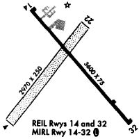
Runway Summary
| Runways: | 04/22 14/32 |
| Longest Runway: | 14/32 is 3600 ft (1097 m) long |
| Runways with an Instrument Approach: |
8D1 Airport Runway Details
| Runway 04/22 | 2951 ft x 250 ft (899 m x 76 m) | |
| Runway Length Source: | 3RD PARTY SURVEY as of 01/29/2010 | |
| Surface: | Turf - Fair condition - No special surface treatment | |
Runway 04 |
Runway 22 |
|
Elevation: |
992.1 | 973.6 |
Latitude: |
43-56-27.2455N | 43-56-49.1078N |
Longitude: |
088-07-12.7500W | 088-06-46.0808W |
|
Runway True Alignment: |
041 | 221 |
Glide Path Angle: |
0.0 degrees | 0.0 degrees |
Traffic Pattern: |
Left | Right |
Runway Markings Type: |
None | None |
Object at End: |
TREES | |
Object Height: |
63 | |
Distance from End: |
935 | |
Object Centerline Offset: |
200 ft. left of centerline | |
REIL: |
No | No |
Touchdown Lights: |
No | No |
Centerline Lights: |
No | No |
| Runway 14/32 | 3600 ft x 75 ft (1097 m x 23 m) | |
| Surface: | Turf - Fair condition - No special surface treatment | |
| Runway Edge Lights: | Medium Intensity | |
Runway Weight Bearing Capacity (in thousands of pounds) |
||
| Single Wheel Landing Gear: | 20.0 | |
Runway 14 |
Runway 32 |
|
Elevation: |
976.6 | 976.5 |
Latitude: |
43-56-53.1430N | 43-56-25.3933N |
Longitude: |
088-07-03.8562W | 088-06-33.1913W |
|
Runway True Alignment: |
141 | 321 |
Glide Path Angle: |
3.2 degrees | 3.0 degrees |
Traffic Pattern: |
Left | Left |
Runway Markings Type: |
Nonprecision Instrument | Nonprecision Instrument |
Runway Markings Condition: |
Fair | Fair |
Object at End: |
TREES | |
Object Height: |
65 | |
Distance from End: |
1240 | |
Object Centerline Offset: |
200 ft. left of centerline | |
Visual Glide Slope Indicators: |
2-Light PAPI On Left Side Of Runway | 2-Light PAPI On Left Side Of Runway |
REIL: |
Yes | Yes |
Touchdown Lights: |
No | No |
Centerline Lights: |
No | No |
Threshold Crossing Height: |
27 | 23 |
Services
Airframe Repair: |
None |
Powerplant Repair: |
None |
Bottled Oxygen: |
None |
Bulk Oxygen: |
None |
Fuel Available: |
100LL, Mogas |
Landing Fees: |
No |
Parking: |
Tiedowns available |
Maps & Diagrams
8D1 Sectional
Flight Planning
at skyvector.com
at skyvector.com