Location
Latitude: |
34-50-52.6000N (34.847944) |
Longitude: |
082-21-00.0000W (-82.35) |
Elevation: |
1048.0 feet MSL (319 m MSL) |
Magnetic Variation: |
7 W (as of April 2024 from WMM2020 model) |
Time Zone: |
UTC -5.0 (Standard Time) UTC -4.0 (Daylight Savings Time) |
From City: |
03 N.M. E of Greenville, South Carolina |
Found On: |
Atlanta Chart |
FAA Region: |
ASO |
Contacts
Manager: |
Publicly owned: |
| JAMES STEPHENS 100 TOWER DR, UNIT 2 GREENVILLE, SC 29607 864-242-4777 |
GREENVILLE AIRPORT COMMISSION 100 TOWER DR, UNIT 2 GREENVILLE, SC 29607 864-242-4777 |
Operations
Airport Status: |
Operational |
Facility Use: |
Public |
Type: |
Airport |
Activation Date: |
09/1937 |
Control tower: |
Yes |
Attendance (Months/Days/Hours): |
Months/Days/Hours ALL/SAT-SUN/0700-2000 |
Boundary ARTCC: |
ZTL (Atlanta) |
Responsible ARTCC: |
ZTL (Atlanta) |
Lighting Schedule: |
SEE RMK |
Segmented Circle Indicator: |
Yes |
Traffic Pattern Altitude (MSL): |
2048 feet (624 m) |
NOTAMs Facility: |
GMU |
NOTAM-D Service: |
Yes |
International Airport of Entry: |
No |
Customs Landing Rights: |
No |
Military Landing Rights: |
Yes |
Civil/Military Joint Use: |
No |
Based Aircraft
| Single Engine: | 158 |
| Multi Engine: | 21 |
| Jet Engine: | 20 |
| GA Helicopters: | 6 |
Annual Operations (as of 12/31/2022)
| Total Operations: | 85103 | |
| Air Taxi: | 14854 | 17.5% |
| GA Local: | 24147 | 28.4% |
| GA Itinerant: | 45269 | 53.2% |
| Military Aircraft: | 833 | 1.0% |
Communications
| CTAF: | 119.900 |
| Unicom: | 122.950 |
| Tower: | GREENVILLE 119.9 257.7 Hrs: 0700-2200 |
| Ground: | 121.25 |
| Approach: | GREER 118.8 118.8 118.8 118.8 118.8 118.8 ATLANTA ARTCC |
| Departure: | GREER 118.8 118.8 118.8 118.8 118.8 118.8 ATLANTA ARTCC |
| ATIS: | 127.075 Hrs: 0700-2200 |
| ASOS: | 127.075 (864-239-0014) |
- APCH/DEP SVC PRVDD BY ATLANTA ARTCC ON FREQS 135.35/263.125 (OWING RCAG) WHEN APCH CTL CLSD.
Fixed Based Operators (FBOs) & Fuel
(Click on a business for detail)
Please help us keep this information up to date. This is a FREE SERVICE just like everything else on Airport Guide! If you see that a business needs to be added, modified, or deleted please fill out our Update Form.
To add, modify, or delete a business click here.
Please help us keep this information up to date. This is a FREE SERVICE just like everything else on Airport Guide! If you see that a business needs to be added, modified, or deleted please fill out our Update Form.
Area Code: 803 |
| Business Name | Frequency | Phone | Fuel Grade |
|---|---|---|---|
| Deb Aviation
Update FBO info |
233-9942 | ||
| Denison Jet A Sales, Inc.
Update FBO info |
271-9500 | ||
| Euroflight, Inc.
Update FBO info |
Unicom 123.3 | 421-0013 | |
| Greenville Aviation Flight School
Update FBO info |
242-4201 | 100LL, Jet A | |
| Greenville Avionics, Div. George Miler
Update FBO info |
242-9232 | ||
| Greenville Jet A Center, Inc.
Update FBO info |
Unicom 122.95 | 452-0379 | 100LL, Jet A |
| Lake Side Aircraft Service
Update FBO info |
271-7800 | ||
| Rhino Aviation
Update FBO info |
232-9566 | ||
| S. C. Aero Club
Update FBO info |
467-0161 | ||
| Southern Jet A
Update FBO info |
Unicom 122.95 | 232-7100, 800-388-9380, after hours pager 290-0490 | 100LL, Jet A |
| TAC Air
Website Update FBO info |
Unicom 122.95, Arinc 129.875 | 864-232-7100 | 100LL, Jet A |
Flight Service Stations
| Primary | Alternate | |
| FSS on Field: | N | |
| FSS Name (ID): | Anderson(AND) | |
| Frequency: | ||
| Toll Free Phone: | 1-800-WX-BRIEF |
Instrument Procedures / Charts
FAA Terminal Procedures valid from 0901Z 03/21/24 to 0901Z 04/18/24.
There are various types of charts available for an airport. They are listed in the Page Type column. Here is a legend for those types:
APD - Airport Diagram
DP - Departure Procedure Charts
HOT - Hot Spots
IAP - Instrument Approach Procedure Charts
MIN - Minimums
STAR - Standard Terminal Arrival Charts
| Page Type | Page Name | Volume | Action Since Last Cycle |
|---|---|---|---|
| APD | AIRPORT DIAGRAM | SE-2 | |
| DP | BIMMR THREE (RNAV) | SE-2 | |
| DP | BWALL TWO (RNAV) | SE-2 | |
| HOT | HOT SPOT | SE-2 | |
| IAP | ILS OR LOC RWY 01 | SE-2 | |
| IAP | RNAV (GPS) RWY 01 | SE-2 | |
| IAP | RNAV (GPS) RWY 10 | SE-2 | |
| IAP | RNAV (GPS) RWY 19 | SE-2 | |
| IAP | RNAV (GPS) RWY 28 | SE-2 | |
| MIN | ALTERNATE MINIMUMS | SE-2 | |
| MIN | TAKEOFF MINIMUMS | SE-2 | |
| STAR | JUNNR THREE (RNAV) | SE-2 | |
| STAR | MCHLN TWO (RNAV) | SE-2 | |
| STAR | RCTOR TWO (RNAV) | SE-2 | |
| STAR | WORXS TWO (RNAV) | SE-2 |
Terminal Procedures are only available for airports in several countries with more being added all the time. If you are looking for a specific country's charts, please send an email to support(at)airportguide.com stating the country name. This will be used to prioritize the implementation.
Navigation Aids (Navaids) near GMU
| Dist (NM) | ID | Morse Code | Name | Type | Freq | True Hdg | Mag Hdg |
|---|---|---|---|---|---|---|---|
| 4.1 | GM | _ _ . _ _ | Judky | NDB | 521 | 179 | 186 |
| 10.5 | GY | _ _ . _ . _ _ | Dyana | NDB | 338 | 206 | 213 |
| 17.5 | LQK | . _ . . _ _ . _ _ . _ | Lake Keowee | NDB | 408 | 262 | 269 |
| 18.2 | FRT | . . _ . . _ . _ | Fairmont | NDB | 248 | 79 | 86 |
| 23.6 | SPA | . . . . _ _ . . _ | Spartanburg | VORTAC | 115.70 | 61 | 68 |
| 26.2 | BRA | _ . . . . _ . . _ | Broad River | NDB | 379 | 346 | 353 |
| 28.4 | CEU | _ . _ . . . . _ | Clemson | NDB | 257 | 248 | 255 |
| 33.5 | ELW | . . _ . . . _ _ | Electric City | VORTAC | 108.60 | 219 | 226 |
| 33.8 | SUG | . . . . . _ _ _ . | Sugarloaf Mountain | VORTAC | 112.20 | 6 | 13 |
| 36.2 | UOT | . . _ _ _ _ _ | Union County | NDB | 326 | 105 | 112 |
| 37.1 | GRD | _ _ . . _ . _ . . | Greenwood | TACAN | 115.50 | 164 | 171 |
| 37.9 | GIW | _ _ . . . . _ _ | Coronaca | NDB | 239 | 159 | 166 |
| 42.7 | IM | . . _ _ | Keans | NDB | 357 | 344 | 351 |
| 44.2 | SLP | . . . . _ . . . _ _ . | First River | NDB | 417 | 56 | 63 |
| 47.6 | ODF | _ _ _ _ . . . . _ . | Foothills | VOR-DME | 113.40 | 259 | 266 |
| 47.8 | EOE | . _ _ _ . | Enoree | NDB | 278 | 132 | 139 |
| 56.7 | DCM | _ . . _ . _ . _ _ | Chester | NDB | 220 | 93 | 100 |
| 61.5 | FIQ | . . _ . . . _ _ . _ | Fiddlers | NDB | 391 | 32 | 39 |
| 62.1 | GHJ | _ _ . . . . . . _ _ _ | Stonia | NDB | 260 | 70 | 77 |
| 62.5 | UZ | . . _ _ _ . . | Rally | NDB | 227 | 87 | 94 |
Nearby Airports with Fuel
Notices to Airmen (NOTAMS)
Remarks
| A110-1 | ACFT OPER IN THE GREENVILLE ARPT TFC AREA S THRU E BE ALERT FOR JET & CONVENTIONAL TFC DES ON THE GREENVILLE-SPARTANBURG LOC COURSE. |
| A110-2 | ACFT INBD FROM THE SSW OR ON ILS RY 01 APCH BE ALERT FOR TFC 4.5 MI S OPERG IN THE DONALDSON FIELD ARPT TFC PAT AT 1800 FT OR BLO. |
| A110-3 | NO OVERNIGHT PARKING ON HELIPADS. |
| A110-4 | NO ACFT PERMITTED ON TWYS 'C' OR 'D' WHEN ACFT GREATER THAN 12,500 LBS IS OPERATING ON RY 10/28. |
| A110-5 | RY 10/28 RESTRICTED TO SMALL ACFT (LESS THAN 12,500 LBS) WHEN ACFT OPERG ON TWYS C OR D. |
| A110-7 | NOISE ABATEMENT PROCEDURES IN EFFECT, CTC ARPT MGR 864-242-4777. |
| A30-01/19 | ARRESTING GEAR/SYSTEM: ENGINEERED MATERIAL ARRESTING SYSTEM (EMAS) 157 FT IN LENGTH BY 113 FT IN WIDTH AT THE DEPARTURE END OF RWY 01. |
| A57-10 | RY 10 APCH IS 28:1 AT DSPLCD THLD. |
| A57-28 | RY 28 APCH IS 36:1 AT DSPLCD THLD. |
| A58-10 | MULT TREES 104 FT FROM RWY 10 PAVEMENT END. |
| A81-APT | ATC-CTL. WHEN ATCT CLSD ACTVT MALSF RWY 01; REIL RWY 19; HIRL RWY 01/19; PERIMETER LGTS H1, H2, AND TXY LGHTS - CTAF. MIRL 10-28 UNAVLBL WHEN TWR CLSD. |
| E111 | ARPT EXISTED PRIOR TO 1959; HELIPADS ARE CONDITIONAL. SEE AIRSPACE LETTER DATED JAN 24, 1990 FOR CONDITIONS. |
| E147 | TPA: 800 FT AGL FOR LGT ACFT, 1000 FT AGL FOR HVY ACFT. |
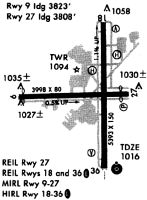
Runways
Runway Summary
| Runways: | 01/19 10/28 H1 H2 |
| Longest Runway: | 01/19 is 5393 ft (1644 m) long |
| Runways with an Instrument Approach: | 01 |
GMU Airport Runway Details
| Runway 01/19 | 5393 ft x 100 ft (1644 m x 30 m) | |
| Runway Length Source: | 3RD PARTY SURVEY as of 05/12/2012 | |
| Surface: | Asphalt - Excellent condition - Saw-cut or plastic grooved | |
| Runway Pavement Class: | 23 /F/C/X/T | |
| Runway Edge Lights: | High Intensity | |
Runway Weight Bearing Capacity (in thousands of pounds) |
||
| Single Wheel Landing Gear: | 61.0 | |
| Dual Wheel Landing Gear: | 81.0 | |
| Dual Tandem Wheel Landing Gear: | 151.0 | |
Runway 01 |
Runway 19 |
|
Elevation: |
988.6 | 1048.0 |
Latitude: |
34-50-25.8158N | 34-51-19.1440N |
Longitude: |
082-20-54.9161W | 082-20-53.5604W |
|
Runway True Alignment: |
001 | 181 |
ILS Type: |
ILS | |
Glide Path Angle: |
3.0 degrees | 3.5 degrees |
Traffic Pattern: |
Left | Right |
Runway Markings Type: |
Precision Instrument | Nonprecision Instrument |
Runway Markings Condition: |
Good | Good |
Arresting Device: |
EMAS | |
Object at End: |
TREE | |
Object Height: |
117 | |
Distance from End: |
2580 | |
Object Centerline Offset: |
406 ft. left of centerline | |
Visual Glide Slope Indicators: |
4-Light PAPI On Left Side Of Runway | 4-Light PAPI On Left Side Of Runway |
Approach Light System: |
1,400 Foot Medium Intensity Approach Lighting System With Sequenced Flashers | |
REIL: |
No | Yes |
Threshold Crossing Height: |
35 | 37 |
| Runway 10/28 | 4000 ft x 80 ft (1219 m x 24 m) | |
| Runway Length Source: | 3RD PARTY SURVEY as of 05/12/2012 | |
| Surface: | Asphalt - Excellent condition - No special surface treatment | |
| Runway Pavement Class: | 16 /F/C/Y/T | |
| Runway Edge Lights: | Medium Intensity | |
Runway Weight Bearing Capacity (in thousands of pounds) |
||
| Single Wheel Landing Gear: | 43.5 | |
| Dual Wheel Landing Gear: | 62.0 | |
Runway 10 |
Runway 28 |
|
Elevation: |
994.3 | 1014.7 |
Latitude: |
34-50-53.1148N | 34-50-52.1917N |
Longitude: |
082-21-31.7398W | 082-20-43.7630W |
|
Runway True Alignment: |
091 | 271 |
Glide Path Angle: |
0.0 degrees | 3.0 degrees |
Traffic Pattern: |
Left | Right |
Runway Markings Type: |
Basic | Basic |
Runway Markings Condition: |
Good | Good |
Object at End: |
TREE | TREE |
Object Height: |
34 | 26 |
Distance from End: |
707 | 444 |
Object Centerline Offset: |
406 ft. left of centerline | |
Visual Glide Slope Indicators: |
2-Light PAPI On Left Side Of Runway | |
REIL: |
No | Yes |
Threshold Crossing Height: |
40 | |
Threshold Elevation: |
992.7 | 1013.2 |
Displaced Threshold: |
267 | 271 |
Threshold Latitude: |
34-50-53.0546N | 34-50-52.2560N |
Threshold Longitude: |
082-21-28.5423W | 082-20-47.0159W |
Declared Distances |
||
Take Off Run Avbl. (TORA): |
3998 | 3998 |
Take Off Distance Avbl. (TODA): |
3998 | 3998 |
Actual Stop Dist. Avbl. (ASDA): |
3728 | 3733 |
Landing Dist. Avbl. (LDA): |
3463 | 3463 |
| Helipad H1 | 50 ft x 50 ft (15 m x 15 m) | |
| Surface: | Asphalt - Excellent condition - No special surface treatment | |
| Runway Edge Lights: | Perimeter lights (for helipads) Intensity | |
Runway Weight Bearing Capacity (in thousands of pounds) |
||
| Single Wheel Landing Gear: | 20.0 | |
Helipad H1 |
||
Glide Path Angle: |
0.0 degrees | 0.0 degrees |
Object Centerline Offset: |
406 ft. left of centerline |
| Helipad H2 | 50 ft x 50 ft (15 m x 15 m) | |
| Surface: | Asphalt - Excellent condition - No special surface treatment | |
| Runway Edge Lights: | Perimeter lights (for helipads) Intensity | |
Runway Weight Bearing Capacity (in thousands of pounds) |
||
| Single Wheel Landing Gear: | 20.0 | |
Helipad H2 |
||
Glide Path Angle: |
0.0 degrees | 0.0 degrees |
Object Centerline Offset: |
406 ft. left of centerline |
Services
Airframe Repair: |
Major |
Powerplant Repair: |
Major |
Bottled Oxygen: |
None |
Bulk Oxygen: |
None |
Fuel Available: |
100LL, Jet A-1+ |
Landing Fees: |
No |
Parking: |
Tiedowns available |
Maps & Diagrams
GMU Sectional
Flight Planning
at skyvector.com
at skyvector.com