Location
Latitude: |
34-48-35.9000N (34.809972) |
Longitude: |
082-42-10.4000W (-82.702889) |
Elevation: |
1013.4 feet MSL (309 m MSL) |
Magnetic Variation: |
6.7 W (as of April 2024 from WMM2020 model) |
Time Zone: |
UTC -5.0 (Standard Time) UTC -4.0 (Daylight Savings Time) |
From City: |
04 N.M. S of Pickens, South Carolina |
Found On: |
Atlanta Chart |
FAA Region: |
ASO |
Contacts
Manager: |
Publicly owned: |
| CARLOS SALINAS 240 AIRPORT ROAD 29657 864-843-5803 |
PICKENS COUNTY 222 MCDANIEL AVE; B-2 PICKENS, SC 29671 (864) 898-5844 |
Operations
Airport Status: |
Operational |
Facility Use: |
Public |
Type: |
Airport |
Control tower: |
No |
Attendance (Months/Days/Hours): |
Months/Days/Hours ALL/ALL/0800-1700 |
Boundary ARTCC: |
ZTL (Atlanta) |
Responsible ARTCC: |
ZTL (Atlanta) |
Lighting Schedule: |
SEE RMK |
Segmented Circle Indicator: |
Yes |
Traffic Pattern Altitude (MSL): |
2013 feet (614 m) |
NOTAMs Facility: |
AND |
NOTAM-D Service: |
Yes |
International Airport of Entry: |
No |
Customs Landing Rights: |
No |
Military Landing Rights: |
Yes |
Civil/Military Joint Use: |
No |
Based Aircraft
| Single Engine: | 31 |
| Multi Engine: | 1 |
| Jet Engine: | 2 |
Annual Operations (as of 06/24/2021)
| Total Operations: | 11000 | |
| Air Taxi: | 611 | 5.6% |
| GA Local: | 4056 | 36.9% |
| GA Itinerant: | 5333 | 48.5% |
| Military Aircraft: | 1000 | 9.1% |
Communications
| CTAF: | 122.800 |
| Unicom: | 122.800 |
| Approach: | GREER 118.8 118.8 ATLANTA ARTCC |
| Departure: | GREER 118.8 118.8 ATLANTA ARTCC |
| AWOS-3: | 120.0 (864-843-5801) |
- APCH/DEP SVC PRVDD BY ATLANTA ARTCC ON FREQS 134.8/379.95 (MOUNT OGLETHORPE RCAG) WHEN APCH CTL CLSD.
Fixed Based Operators (FBOs) & Fuel
(Click on a business for detail)
Please help us keep this information up to date. This is a FREE SERVICE just like everything else on Airport Guide! If you see that a business needs to be added, modified, or deleted please fill out our Update Form.
To add, modify, or delete a business click here.
Please help us keep this information up to date. This is a FREE SERVICE just like everything else on Airport Guide! If you see that a business needs to be added, modified, or deleted please fill out our Update Form.
Area Code: 864 |
| Business Name | Frequency | Phone | Fuel Grade |
|---|---|---|---|
| Pickens County Aero
Update FBO info |
Unicom 122.8 | 800-405-5275, 843-6359 | 80, 100LL, Jet A |
Flight Service Stations
| Primary | Alternate | |
| FSS on Field: | N | |
| FSS Name (ID): | Anderson(AND) | |
| Frequency: | ||
| Toll Free Phone: | 1-800-WX-BRIEF |
Instrument Procedures / Charts
FAA Terminal Procedures valid from 0901Z 03/21/24 to 0901Z 04/18/24.
There are various types of charts available for an airport. They are listed in the Page Type column. Here is a legend for those types:
APD - Airport Diagram
DP - Departure Procedure Charts
HOT - Hot Spots
IAP - Instrument Approach Procedure Charts
MIN - Minimums
STAR - Standard Terminal Arrival Charts
| Page Type | Page Name | Volume | Action Since Last Cycle |
|---|---|---|---|
| IAP | RNAV (GPS) RWY 05 | SE-2 | |
| IAP | RNAV (GPS) RWY 23 | SE-2 | |
| MIN | TAKEOFF MINIMUMS | SE-2 |
Terminal Procedures are only available for airports in several countries with more being added all the time. If you are looking for a specific country's charts, please send an email to support(at)airportguide.com stating the country name. This will be used to prioritize the implementation.
Navigation Aids (Navaids) near LQK
| Dist (NM) | ID | Morse Code | Name | Type | Freq | True Hdg | Mag Hdg |
|---|---|---|---|---|---|---|---|
| 0.1 | LQK | . _ . . _ _ . _ _ . _ | Lake Keowee | NDB | 408 | 337 | 344 |
| 12.2 | CEU | _ . _ . . . . _ | Clemson | NDB | 257 | 228 | 235 |
| 14.6 | GY | _ _ . _ . _ _ | Dyana | NDB | 338 | 119 | 126 |
| 17.5 | GM | _ _ . _ _ | Judky | NDB | 521 | 95 | 102 |
| 23.8 | ELW | . . _ . . . _ _ | Electric City | VORTAC | 108.60 | 189 | 196 |
| 30.0 | BRA | _ . . . . _ . . _ | Broad River | NDB | 379 | 22 | 29 |
| 30.1 | ODF | _ _ _ _ . . . . _ . | Foothills | VOR-DME | 113.40 | 257 | 264 |
| 35.7 | FRT | . . _ . . _ . _ | Fairmont | NDB | 248 | 80 | 87 |
| 40.5 | SPA | . . . . _ _ . . _ | Spartanburg | VORTAC | 115.70 | 70 | 77 |
| 41.7 | SUG | . . . . . _ _ _ . | Sugarloaf Mountain | VORTAC | 112.20 | 30 | 37 |
| 43.1 | GRD | _ _ . . _ . _ . . | Greenwood | TACAN | 115.50 | 140 | 147 |
| 43.7 | IM | . . _ _ | Keans | NDB | 357 | 7 | 14 |
| 45.1 | GIW | _ _ . . . . _ _ | Coronaca | NDB | 239 | 137 | 144 |
| 45.7 | AJR | . _ . _ _ _ . _ . | Habersham | NDB | 347 | 246 | 252 |
| 52.8 | UOT | . . _ _ _ _ _ | Union County | NDB | 326 | 97 | 104 |
| 57.5 | BJT | _ . . . . _ _ _ _ | Bulldog | NDB | 221 | 206 | 213 |
| 60.2 | AHN | . _ . . . . _ . | Athens | VOR-DME | 116.95 | 210 | 216 |
| 60.2 | HRS | . . . . . _ . . . . | Harris | VORTAC | 109.80 | 277 | 283 |
| 60.4 | SLP | . . . . _ . . . _ _ . | First River | NDB | 417 | 63 | 70 |
| 60.4 | DDA | _ . . _ . . . _ | Commerce | NDB | 244 | 222 | 228 |
Nearby Airports with Fuel
Notices to Airmen (NOTAMS)
Remarks
| A110-3 | NOISE ABATEMENT PROCEDURE IN EFFECT, PHONE 864-843-5803. |
| A110-4 | FOR CD CTC GREER APCH AT 864-877-8275. WHEN GREER APCH CLSD, FOR CD CTC ATLANTA ARTCC AT 770-210-7692. |
| A81-APT | ACTVT PAPI RWY 05 & 23; MIRL RWY 05/23 - CTAF. |
Runways
Runway Summary
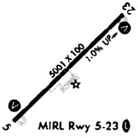
| Runways: | 05/23 |
| Longest Runway: | 05/23 is 5002 ft (1525 m) long |
| Runways with an Instrument Approach: |
LQK Airport Runway Details
| Runway 05/23 | 5002 ft x 100 ft (1525 m x 30 m) | |
| Runway Length Source: | 3RD PARTY SURVEY as of 02/01/2008 | |
| Surface: | Asphalt - Good condition - No special surface treatment | |
| Runway Pavement Class: | 29 /F/C/X/T | |
| Runway Edge Lights: | Medium Intensity | |
Runway Weight Bearing Capacity (in thousands of pounds) |
||
| Single Wheel Landing Gear: | 75.0 | |
| Dual Wheel Landing Gear: | 101.0 | |
Runway 05 |
Runway 23 |
|
Elevation: |
963.7 | 1013.4 |
Latitude: |
34-48-18.0785N | 34-48-53.7203N |
Longitude: |
082-42-31.1569W | 082-41-49.5780W |
|
Runway True Alignment: |
044 | 224 |
Glide Path Angle: |
3.0 degrees | 3.0 degrees |
Traffic Pattern: |
Left | Left |
Runway Markings Type: |
Nonprecision Instrument | Nonprecision Instrument |
Runway Markings Condition: |
Good | Good |
Object at End: |
TREE | |
Object Height: |
52 | |
Distance from End: |
1076 | |
Object Centerline Offset: |
234 ft. right of centerline | |
Visual Glide Slope Indicators: |
2-Light PAPI On Left Side Of Runway | 2-Light PAPI On Left Side Of Runway |
REIL: |
No | No |
Touchdown Lights: |
No | No |
Centerline Lights: |
No | No |
Threshold Crossing Height: |
35 | 26 |
Services
Airframe Repair: |
Major |
Powerplant Repair: |
Major |
Bottled Oxygen: |
None |
Bulk Oxygen: |
None |
Fuel Available: |
100LL |
Landing Fees: |
No |
Parking: |
Tiedowns available |
Maps & Diagrams
LQK Sectional
Flight Planning
at skyvector.com
at skyvector.com