Location
Latitude: |
35-25-41.6000N (35.428222) |
Longitude: |
081-56-06.2800W (-81.935078) |
Elevation: |
1077.3 feet MSL (328 m MSL) |
Magnetic Variation: |
7.3 W (as of April 2024 from WMM2020 model) |
Time Zone: |
UTC -5.0 (Standard Time) UTC -4.0 (Daylight Savings Time) |
From City: |
03 N.M. N of Rutherfordton, North Carolina |
Found On: |
Charlotte Chart |
FAA Region: |
ASO |
Contacts
Manager: |
Publicly owned: |
| DEVON RAISCH 110 MARCHMAN FIELD DRIVE, SUITE 102 RUTHERFORDTON, NC 28139 (828) 287-0800 |
RUTHERFORD COUNTY ARPT AUTH 110 MARCHMAN FIELD DRIVE RUTHERFORDTON, NC 28139 828-287-0800 |
Operations
Airport Status: |
Operational |
Facility Use: |
Public |
Type: |
Airport |
Activation Date: |
11/1975 |
Control tower: |
No |
Attendance (Months/Days/Hours): |
Months/Days/Hours ALL/ALL/0900-1800 |
Boundary ARTCC: |
ZTL (Atlanta) |
Responsible ARTCC: |
ZTL (Atlanta) |
Lighting Schedule: |
SEE RMK |
Segmented Circle Indicator: |
No |
Traffic Pattern Altitude (MSL): |
2077 feet (633 m) |
NOTAMs Facility: |
FQD |
NOTAM-D Service: |
Yes |
International Airport of Entry: |
No |
Customs Landing Rights: |
No |
Military Landing Rights: |
Yes |
Civil/Military Joint Use: |
No |
Based Aircraft
| Single Engine: | 41 |
| Multi Engine: | 8 |
| Jet Engine: | 3 |
| GA Helicopters: | 3 |
Annual Operations (as of 07/03/2023)
| Total Operations: | 12150 | |
| GA Local: | 3650 | 30.0% |
| GA Itinerant: | 8000 | 65.8% |
| Military Aircraft: | 500 | 4.1% |
Communications
| CTAF: | 122.800 |
| Unicom: | 122.800 |
| Approach: | GREER 119.4 119.4 ATLANTA ARTCC |
| Departure: | GREER 119.4 119.4 ATLANTA ARTCC |
| AWOS-3: | 118.275 (828-287-6498) |
- APCH/DEP SVC PRVDD BY ATLANTA ARTCC ON FREQS 132.625/353.625 (SUGARLOAF MOUNTAIN RCAG) WHEN APCH CTL CLSD.
Fixed Based Operators (FBOs) & Fuel
(Click on a business for detail)
Please help us keep this information up to date. This is a FREE SERVICE just like everything else on Airport Guide! If you see that a business needs to be added, modified, or deleted please fill out our Update Form.
To add, modify, or delete a business click here.
Please help us keep this information up to date. This is a FREE SERVICE just like everything else on Airport Guide! If you see that a business needs to be added, modified, or deleted please fill out our Update Form.
Area Code: 828 |
| Business Name | Frequency | Phone | Fuel Grade |
|---|---|---|---|
| Free Spirit Aviation
Update FBO info |
Unicom 122.8 | 287-0800 | 100LL, Jet A |
Flight Service Stations
| Primary | Alternate | |
| FSS on Field: | N | |
| FSS Name (ID): | Raleigh(RDU) | |
| Frequency: | ||
| Toll Free Phone: | 1-800-WX-BRIEF |
Instrument Procedures / Charts
FAA Terminal Procedures valid from 0901Z 03/21/24 to 0901Z 04/18/24.
There are various types of charts available for an airport. They are listed in the Page Type column. Here is a legend for those types:
APD - Airport Diagram
DP - Departure Procedure Charts
HOT - Hot Spots
IAP - Instrument Approach Procedure Charts
MIN - Minimums
STAR - Standard Terminal Arrival Charts
| Page Type | Page Name | Volume | Action Since Last Cycle |
|---|---|---|---|
| IAP | LOC RWY 01 | SE-2 | |
| IAP | RNAV (GPS) RWY 01 | SE-2 | |
| IAP | RNAV (GPS) RWY 19 | SE-2 | |
| MIN | ALTERNATE MINIMUMS | SE-2 | |
| MIN | TAKEOFF MINIMUMS | SE-2 |
Terminal Procedures are only available for airports in several countries with more being added all the time. If you are looking for a specific country's charts, please send an email to support(at)airportguide.com stating the country name. This will be used to prioritize the implementation.
Navigation Aids (Navaids) near KFQD
| Dist (NM) | ID | Morse Code | Name | Type | Freq | True Hdg | Mag Hdg |
|---|---|---|---|---|---|---|---|
| 16.4 | SUG | . . . . . _ _ _ . | Sugarloaf Mountain | VORTAC | 112.20 | 265 | 272 |
| 19.5 | SLP | . . . . _ . . . _ _ . | First River | NDB | 417 | 122 | 129 |
| 21.3 | FIQ | . . _ . . . _ _ . _ | Fiddlers | NDB | 391 | 37 | 44 |
| 23.7 | SPA | . . . . _ _ . . _ | Spartanburg | VORTAC | 115.70 | 179 | 186 |
| 26.8 | MRN | _ _ . _ . _ . | Lenoir | FAN MARKER | 34 | 41 | |
| 27.8 | BRA | _ . . . . _ . . _ | Broad River | NDB | 379 | 250 | 257 |
| 31.7 | FRT | . . _ . . _ . _ | Fairmont | NDB | 248 | 184 | 191 |
| 32.5 | IM | . . _ _ | Keans | NDB | 357 | 281 | 288 |
| 32.6 | HKY | . . . . _ . _ _ . _ _ | Hickory Regional | VOT | 110.00 | 54 | 62 |
| 37.5 | HK | . . . . _ . _ | Tawba | NDB | 332 | 54 | 62 |
| 40.6 | GHJ | _ _ . . . . . . _ _ _ | Stonia | NDB | 260 | 110 | 118 |
| 42.0 | IZN | . . _ _ . . _ . | Lincolnton | NDB | 432 | 80 | 88 |
| 43.0 | BZM | _ . . . _ _ . . _ _ | Barretts Mountain | VOR-DME | 113.75 | 51 | 59 |
| 43.6 | BAR | _ . . . . _ . _ . | Hemlock | NDB | 320 | 3 | 10 |
| 43.9 | GM | _ _ . _ _ | Judky | NDB | 521 | 207 | 214 |
| 46.9 | UOT | . . _ _ _ _ _ | Union County | NDB | 326 | 162 | 169 |
| 49.4 | CLT | _ . _ . . _ . . _ | Charlotte | VOT | 112.00 | 104 | 112 |
| 50.2 | CLT | _ . _ . . _ . . _ | Charlotte | VOR-DME | 115.00 | 106 | 114 |
| 50.8 | GY | _ _ . _ . _ _ | Dyana | NDB | 338 | 209 | 216 |
| 52.8 | DCM | _ . . _ . _ . _ _ | Chester | NDB | 220 | 136 | 144 |
Nearby Airports with Fuel
Notices to Airmen (NOTAMS)
Remarks
| A110-1 | RWY 01 HAS 100 FT DROP-OFF 315 FT FM THR OFFSET 140 FT RIGHT AND 160 FT LEFT OF CNTRLN; AND 100 FT DROP-OFF 700-900 FT ALONG CNTRLN OFFSET 80 FT RIGHT. |
| A110-2 | DEER IN VICINITY OF ARPT. |
| A110-3 | FOR CD CTC GREER APCH AT 864-877-8275. WHEN GREER APCH CLSD, FOR CD CTC ATLANTA ARTCC AT 770-210-7692. |
| A110-4 | TWY A TOWARD RWY 1 HAS 30 FT DROP-OFF 60 FT RIGHT OF CNTRLN. |
| A110-5 | RWY 19 HAS 12 FT UNMARKED POWER LINES 440 FT FM THR BOTH SIDES OF CNTRLN. |
| A16 | MGR MOBILE PH# 828-748-5480. |
| A58-19 | 6 FT FENCE 0-200 FT FM THR OFFSET 182 FT LEFT OF CNTRLN. |
| A70-FUEL-10 | 0LL 100LL AND JET A 24 SELF SVC FUEL AVBL WITH CREDIT CARD. |
| A81-APT | ACTVT REIL RWY 01 & 19; PAPI RWY 01 & 19; MIRL RWY 01/19 - CTAF. |
Runways
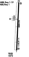
Runway Summary
| Runways: | 01/19 |
| Longest Runway: | 01/19 is 5000 ft (1524 m) long |
| Runways with an Instrument Approach: | 01 |
KFQD Airport Runway Details
| Runway 01/19 | 5000 ft x 100 ft (1524 m x 30 m) | |
| Runway Length Source: | 3RD PARTY SURVEY as of 11/30/2007 | |
| Surface: | Asphalt - Excellent condition - No special surface treatment | |
| Runway Edge Lights: | Medium Intensity | |
Runway Weight Bearing Capacity (in thousands of pounds) |
||
| Single Wheel Landing Gear: | 50.0 | |
| Dual Wheel Landing Gear: | 75.0 | |
Runway 01 |
Runway 19 |
|
Elevation: |
1057.1 | 1077.3 |
Latitude: |
35-25-16.9898N | 35-26-06.3097N |
Longitude: |
081-56-08.1709W | 081-56-04.3701W |
|
Runway True Alignment: |
004 | 184 |
ILS Type: |
LOC/DME | |
Glide Path Angle: |
3.0 degrees | 3.2 degrees |
Traffic Pattern: |
Left | Left |
Runway Markings Type: |
Precision Instrument | Nonprecision Instrument |
Runway Markings Condition: |
Good | Good |
Object at End: |
TREES | TREES |
Object Height: |
27 | 24 |
Distance from End: |
804 | 327 |
Object Centerline Offset: |
288 ft. left of centerline | 254 ft. right of centerline |
Visual Glide Slope Indicators: |
2-Light PAPI On Left Side Of Runway | 2-Light PAPI On Left Side Of Runway |
REIL: |
Yes | Yes |
Threshold Crossing Height: |
40 | 40 |
Services
Airframe Repair: |
Major |
Powerplant Repair: |
Major |
Bottled Oxygen: |
None |
Bulk Oxygen: |
None |
Fuel Available: |
100LL |
Landing Fees: |
No |
Parking: |
Tiedowns available |
Maps & Diagrams
KFQD Sectional
Flight Planning
at skyvector.com
at skyvector.com