Location
Latitude: |
34-35-34.1220N (34.592812) |
Longitude: |
083-17-46.9380W (-83.296372) |
Elevation: |
996.0 feet MSL (304 m MSL) |
Magnetic Variation: |
6.3 W (as of April 2024 from WMM2020 model) |
Time Zone: |
UTC -5.0 (Standard Time) UTC -4.0 (Daylight Savings Time) |
From City: |
02 N.M. NE of Toccoa, Georgia |
Found On: |
Atlanta Chart |
FAA Region: |
ASO |
Contacts
Manager: |
Publicly owned: |
| AMBER MCCALL PO BOX 494 TOCCOA, GA 30577 706-886-5632 |
TOCCOA-STEPHENS CO AUTH PO BOX 494 TOCCOA, GA 30577 706-886-5632 |
Operations
Airport Status: |
Operational |
Facility Use: |
Public |
Type: |
Airport |
Activation Date: |
04/1940 |
Control tower: |
No |
Attendance (Months/Days/Hours): |
Months/Days/Hours ALL/MON-SAT/0900-1800 |
Boundary ARTCC: |
ZTL (Atlanta) |
Responsible ARTCC: |
ZTL (Atlanta) |
Lighting Schedule: |
SEE RMK |
Segmented Circle Indicator: |
Yes |
Traffic Pattern Altitude (MSL): |
1996 feet (608 m) |
NOTAMs Facility: |
MCN |
NOTAM-D Service: |
Yes |
International Airport of Entry: |
No |
Customs Landing Rights: |
No |
Military Landing Rights: |
Yes |
Civil/Military Joint Use: |
No |
Based Aircraft
| Single Engine: | 37 |
| Multi Engine: | 5 |
| Jet Engine: | 1 |
Annual Operations (as of 12/31/2022)
| Total Operations: | 20000 | |
| GA Local: | 7000 | 35.0% |
| GA Itinerant: | 13000 | 65.0% |
Communications
| CTAF: | 122.800 |
| Unicom: | 122.800 |
| AWOS-3: | 119.625 (706-297-7473) |
- APCH/DEP SVC PRVDD BY ATLANTA ARTCC ON FREQS 134.8/379.95 (MOUNT OGLETHORPE RCAG).
Fixed Based Operators (FBOs) & Fuel
(Click on a business for detail)
Please help us keep this information up to date. This is a FREE SERVICE just like everything else on Airport Guide! If you see that a business needs to be added, modified, or deleted please fill out our Update Form.
To add, modify, or delete a business click here.
Please help us keep this information up to date. This is a FREE SERVICE just like everything else on Airport Guide! If you see that a business needs to be added, modified, or deleted please fill out our Update Form.
Area Code: 706 |
| Business Name | Frequency | Phone | Fuel Grade |
|---|---|---|---|
| Foothills Aviation
Update FBO info |
886-6341 | ||
| Toccoa Aviation, Inc.
Update FBO info |
Unicom 122.8 | 886-1320 | 100LL, Jet A |
Flight Service Stations
| Primary | Alternate | |
| FSS on Field: | N | |
| FSS Name (ID): | Macon(MCN) | |
| Frequency: | ||
| Toll Free Phone: | 1-800-WX-BRIEF |
Instrument Procedures / Charts
FAA Terminal Procedures valid from 0901Z 03/21/24 to 0901Z 04/18/24.
There are various types of charts available for an airport. They are listed in the Page Type column. Here is a legend for those types:
APD - Airport Diagram
DP - Departure Procedure Charts
HOT - Hot Spots
IAP - Instrument Approach Procedure Charts
MIN - Minimums
STAR - Standard Terminal Arrival Charts
| Page Type | Page Name | Volume | Action Since Last Cycle |
|---|---|---|---|
| IAP | RNAV (GPS) RWY 03 | SE-4 | |
| IAP | RNAV (GPS) RWY 21 | SE-4 | |
| MIN | TAKEOFF MINIMUMS | SE-4 |
Terminal Procedures are only available for airports in several countries with more being added all the time. If you are looking for a specific country's charts, please send an email to support(at)airportguide.com stating the country name. This will be used to prioritize the implementation.
Navigation Aids (Navaids) near TOC
| Dist (NM) | ID | Morse Code | Name | Type | Freq | True Hdg | Mag Hdg |
|---|---|---|---|---|---|---|---|
| 6.2 | ODF | _ _ _ _ . . . . _ . | Foothills | VOR-DME | 113.40 | 359 | 365 |
| 13.7 | AJR | . _ . _ _ _ . _ . | Habersham | NDB | 347 | 246 | 252 |
| 20.8 | CEU | _ . _ . . . . _ | Clemson | NDB | 257 | 76 | 82 |
| 27.4 | ELW | . . _ . . . _ _ | Electric City | VORTAC | 108.60 | 112 | 118 |
| 32.0 | LQK | . _ . . _ _ . _ _ . _ | Lake Keowee | NDB | 408 | 65 | 72 |
| 33.7 | DDA | _ . . _ . . . _ | Commerce | NDB | 244 | 199 | 205 |
| 37.1 | HRS | . . . . . _ . . . . | Harris | VORTAC | 109.80 | 304 | 310 |
| 38.2 | FKV | . . _ . _ . _ . . . _ | Flowery Branch | NDB | 365 | 232 | 238 |
| 38.7 | BJT | _ . . . . _ _ _ _ | Bulldog | NDB | 221 | 174 | 180 |
| 38.7 | AHN | . _ . . . . _ . | Athens | VOR-DME | 116.95 | 182 | 188 |
| 42.0 | BMW | _ . . . _ _ . _ _ | Barrow County | NDB | 404 | 200 | 206 |
| 42.5 | GY | _ _ . _ . _ _ | Dyana | NDB | 338 | 81 | 88 |
| 44.4 | TX | _ _ . . _ | Gwnet | NDB | 419 | 219 | 225 |
| 48.0 | GM | _ _ . _ _ | Judky | NDB | 521 | 76 | 83 |
| 54.6 | IIY | . . . . _ . _ _ | Washington/Wilkes County | NDB | 435 | 153 | 159 |
| 55.6 | JNM | . _ _ _ _ . _ _ | Monroe | NDB | 392 | 202 | 208 |
| 57.6 | BRA | _ . . . . _ . . _ | Broad River | NDB | 379 | 44 | 51 |
| 58.4 | VV | . . . _ . . . _ | Junne | NDB | 353 | 166 | 172 |
| 60.1 | GRD | _ _ . . _ . _ . . | Greenwood | TACAN | 115.50 | 109 | 116 |
| 62.4 | DJD | _ . . . _ _ _ _ . . | Chero | NDB | 415 | 251 | 257 |
Nearby Airports with Fuel
Notices to Airmen (NOTAMS)
Remarks
| A110-1 | DEER ON OR INVOF ARPT |
| A110-2 | FOR CD CTC ATLANTA ARTCC AT 770-210-7692. |
| A110-3 | HI GND STARTING 170 FT FM RCL EAST AND WEST OF APCH END RWY 21 AND DEP RWY 03. |
| A57-09 | CONTROLLING OBSTRUCTION EXCEEDS A 45 DEGREE SLOPE |
| A81-APT | DUSK-2200. AFTER 2200 ACTVT MIRL RY 03/21, REIL RYS 03 & 21, PAPI RYS 03 & 21 - CTAF. |
Runways
Runway Summary
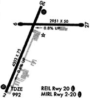
| Runways: | 03/21 09/27 |
| Longest Runway: | 03/21 is 5008 ft (1526 m) long |
| Runways with an Instrument Approach: |
TOC Airport Runway Details
| Runway 03/21 | 5008 ft x 100 ft (1526 m x 30 m) | |
| Runway Length Source: | 3RD PARTY SURVEY as of 01/10/2006 | |
| Surface: | Asphalt - Good condition - No special surface treatment | |
| Runway Edge Lights: | Medium Intensity | |
Runway Weight Bearing Capacity (in thousands of pounds) |
||
| Single Wheel Landing Gear: | 30.0 | |
Runway 03 |
Runway 21 |
|
Elevation: |
995.7 | 968.3 |
Latitude: |
34-35-05.5324N | 34-35-51.8209N |
Longitude: |
083-18-03.5507W | 083-17-42.2256W |
|
Runway True Alignment: |
021 | 201 |
Glide Path Angle: |
3.2 degrees | 3.0 degrees |
Traffic Pattern: |
Left | Left |
Runway Markings Type: |
Nonprecision Instrument | Nonprecision Instrument |
Runway Markings Condition: |
Fair | Fair |
Object at End: |
TREES | TREES |
Object Height: |
51 | 18 |
Distance from End: |
1271 | 218 |
Object Centerline Offset: |
343 ft. left of centerline | 247 ft. right of centerline |
Visual Glide Slope Indicators: |
2-Light PAPI On Left Side Of Runway | 2-Light PAPI On Left Side Of Runway |
REIL: |
Yes | Yes |
Threshold Crossing Height: |
32 | 33 |
| Runway 09/27 | 2951 ft x 50 ft (899 m x 15 m) | |
| Surface: | Asphalt - Good condition - No special surface treatment | |
Runway Weight Bearing Capacity (in thousands of pounds) |
||
| Single Wheel Landing Gear: | 20.0 | |
Runway 09 |
Runway 27 |
|
Elevation: |
972.0 | 948.0 |
Latitude: |
34-35-42.8630N | 34-35-43.7170N |
Longitude: |
083-17-54.5340W | 083-17-19.2450W |
|
Runway True Alignment: |
088 | 268 |
Glide Path Angle: |
0.0 degrees | 0.0 degrees |
Traffic Pattern: |
Left | Left |
Runway Markings Type: |
Basic | Basic |
Runway Markings Condition: |
Good | Good |
Object at End: |
TREES | TREES |
Object Height: |
18 | 38 |
Distance from End: |
296 | 211 |
Object Centerline Offset: |
343 ft. left of centerline | 247 ft. right of centerline |
Services
Airframe Repair: |
Minor |
Powerplant Repair: |
Minor |
Bottled Oxygen: |
None |
Bulk Oxygen: |
None |
Fuel Available: |
100LL |
Landing Fees: |
No |
Parking: |
Tiedowns available |
Maps & Diagrams
TOC Sectional
Flight Planning
at skyvector.com
at skyvector.com