Location
Latitude: |
35-26-10.0070N (35.436113) |
Longitude: |
082-32-31.3710W (-82.542048) |
Elevation: |
2163.9 feet MSL (660 m MSL) |
Magnetic Variation: |
7 W (as of December 2025 from WMM2020 model) |
Time Zone: |
UTC -5.0 (Standard Time) UTC -4.0 (Daylight Savings Time) |
From City: |
09 N.M. S of Asheville, North Carolina |
Found On: |
Atlanta Chart |
FAA Region: |
ASO |
Contacts
Manager: |
Publicly owned: |
| LEW S. BLEIWEIS, A.A.E. 61 TERMINAL DRIVE; SUITE 1 FLETCHER, NC 28731-9442 828-684-4577 |
GREATER ASHEVILLE RGNL ARPT AUTH. 61 TERMINAL DR SUITE 1 FLETCHER, NC 28732-9442 828-684-2226 |
Operations
Airport Status: |
Operational |
Facility Use: |
Public |
Type: |
Airport |
Activation Date: |
01/1961 |
Control tower: |
Yes |
Attendance (Months/Days/Hours): |
Months/Days/Hours ALL/ALL/ALL |
Boundary ARTCC: |
ZTL (Atlanta) |
Responsible ARTCC: |
ZTL (Atlanta) |
Lighting Schedule: |
SEE RMK |
Segmented Circle Indicator: |
Yes |
Traffic Pattern Altitude (MSL): |
3164 feet (964 m) |
NOTAMs Facility: |
AVL |
NOTAM-D Service: |
Yes |
International Airport of Entry: |
No |
Customs Landing Rights: |
No |
Military Landing Rights: |
Yes |
Civil/Military Joint Use: |
No |
Aircraft Rescue and Firefighting: |
Class I ARFF Index: B Air Carrier Service: Scheduled Certification Date: 05/1973 |
Based Aircraft
Annual Operations (as of )
Communications
| CTAF: | 121.100 |
| Unicom: | 122.950 |
| Tower: | ASHEVILLE 121.1 257.8 Hrs: 0630-2300 |
| Ground: | 121.9 |
| Approach: | ASHEVILLE 124.65 ;080-299 125.8 ;300-079 269.575 ;300-079 351.8 ;080-299 Hrs: 0630-2300 ATLANTA ARTCC Hrs: 2300-0630 |
| Departure: | ASHEVILLE 124.65 ;080-299 125.8 ;300-079 269.575 ;300-079 351.8 ;080-299 Hrs: 0630-2300 ATLANTA ARTCC Hrs: 2300-0630 |
| ATIS: | 120.2 Hrs: 24 |
| ASOS: | (828-202-3316) |
| ASHEVILLE DP: | 125.8 ;RWY 35 |
| EMERG: | 243.0 |
| EMERG: | 121.5 |
| CLASS C: | 269.575 ;300-079 |
| CLASS C: | 124.65 ;080-299 |
| ASHEVILLE DP: | 269.575 ;RWY 35 |
| ASHEVILLE DP: | 124.65 ;RWY 17 |
| CLASS C: | 351.8 ;080-299 |
| CLASS C: | 125.8 ;300-079 |
| ASHEVILLE DP: | 351.8 ;RWY 17 |
- COMM UNAVBL BLO 6000 FT EXCP BY RDU RADIO ON FREQ 122.3 (SUGARLOAF MOUNTAIN RCO) WHEN AVL APCH CTL CLSD.
- APCH/DEP SVC PRVDD BY ATLANTA ARTCC ON FREQS 132.625/353.625 (SUGARLOAF MOUNTAIN RCAG) WHEN APCH CTL CLSD.
Fixed Based Operators (FBOs) & Fuel
(Click on a business for detail)
Please help us keep this information up to date. This is a FREE SERVICE just like everything else on Airport Guide! If you see that a business needs to be added, modified, or deleted please fill out our .
To add, modify, or delete a business .
Please help us keep this information up to date. This is a FREE SERVICE just like everything else on Airport Guide! If you see that a business needs to be added, modified, or deleted please fill out our .
Area Code: 828 |
| Business Name | Frequency | Phone | Fuel Grade |
|---|---|---|---|
| Asheville Jet A Center
|
Unicom 122.95 | 684-6832 | 100LL, Jet A |
| Signature Flight Support
|
+1 828 687 7110 |
Flight Service Stations
| Primary | Alternate | |
| FSS on Field: | N | |
| FSS Name (ID): | Raleigh(RDU) | |
| Frequency: | ||
| Toll Free Phone: | 1-800-WX-BRIEF |
Instrument Procedures / Charts
FAA Terminal Procedures valid from 0901Z 11/27/25 to 0901Z 12/25/25.
There are various types of charts available for an airport. They are listed in the Page Type column. Here is a legend for those types:
APD - Airport Diagram
DP - Departure Procedure Charts
HOT - Hot Spots
IAP - Instrument Approach Procedure Charts
MIN - Minimums
STAR - Standard Terminal Arrival Charts
| Page Type | Page Name | Volume | Action Since Last Cycle |
|---|---|---|---|
| APD | AIRPORT DIAGRAM | SE-2 | |
| DP | ASHEVILLE SEVEN | SE-2 | |
| HOT | HOT SPOT | SE-2 | |
| IAP | ILS OR LOC RWY 17 | SE-2 | |
| IAP | ILS OR LOC RWY 35 | SE-2 | |
| IAP | RNAV (GPS) RWY 17 | SE-2 | |
| IAP | RNAV (GPS) RWY 35 | SE-2 | |
| MIN | ALTERNATE MINIMUMS | SE-2 | |
| MIN | TAKEOFF MINIMUMS | SE-2 |
Terminal Procedures are only available for airports in several countries with more being added all the time. If you are looking for a specific country's charts, please send an email to support(at)airportguide.com stating the country name. This will be used to prioritize the implementation.
Navigation Aids (Navaids) near AVL
| Dist (NM) | ID | Morse Code | Name | Type | Freq | True Hdg | Mag Hdg |
|---|---|---|---|---|---|---|---|
| 6.2 | IM | . . _ _ | Keans | NDB | 357 | 339 | 346 |
| 10.4 | BRA | _ . . . . _ . . _ | Broad River | NDB | 379 | 160 | 167 |
| 13.5 | SUG | . . . . . _ _ _ . | Sugarloaf Mountain | VORTAC | 112.20 | 97 | 104 |
| 32.7 | SOT | . . . _ _ _ _ | Snowbird | VORTAC | 108.80 | 310 | 317 |
| 38.3 | LQK | . _ . . _ _ . _ _ . _ | Lake Keowee | NDB | 408 | 191 | 198 |
| 38.6 | SPA | . . . . _ _ . . _ | Spartanburg | VORTAC | 115.70 | 128 | 135 |
| 40.5 | GM | _ _ . _ _ | Judky | NDB | 521 | 166 | 173 |
| 42.1 | FRT | . . _ . . _ . _ | Fairmont | NDB | 248 | 139 | 146 |
| 45.0 | GY | _ _ . _ . _ _ | Dyana | NDB | 338 | 173 | 180 |
| 45.3 | DYQ | _ . . _ . _ _ _ _ . _ | Dulaney | NDB | 263 | 338 | 345 |
| 45.6 | FIQ | . . _ . . . _ _ . _ | Fiddlers | NDB | 391 | 68 | 75 |
| 47.5 | SLP | . . . . _ . . . _ _ . | First River | NDB | 417 | 103 | 110 |
| 48.8 | CEU | _ . _ . . . . _ | Clemson | NDB | 257 | 200 | 207 |
| 49.7 | MRN | _ _ . _ . _ . | Lenoir | FAN MARKER | 63 | 70 | |
| 53.8 | BAR | _ . . . . _ . _ . | Hemlock | NDB | 320 | 36 | 43 |
| 54.4 | EZT | . _ _ . . _ | Elizabethton | NDB | 275 | 13 | 20 |
| 57.8 | BO | _ . . . _ _ _ | Booie | NDB | 221 | 2 | 9 |
| 57.9 | ODF | _ _ _ _ . . . . _ . | Foothills | VOR-DME | 113.40 | 220 | 227 |
| 59.1 | HKY | . . . . _ . _ _ . _ _ | Hickory Regional | VOT | 110.00 | 71 | 78 |
| 60.9 | JXT | . _ _ _ _ . . _ _ | Jefferson | NDB | 346 | 311 | 318 |
Nearby Airports with Fuel
Notices to Airmen (NOTAMS)
Remarks
| A110-1 | FOR THE ASHEVILLE REGIONAL AIRPORT AIRCRAFT DIVERSIONS EMERGENCY CONTINGENCY PLAN AND FACILITY CONSTRAINTS CTC ARPT ADMIN AT 828-684-2226. |
| A110-2 | FLOCKS OF MIGRATORY BIRDS ON AND INVOF ARPT. |
| A110-5 | WHEN ATCT CLSD, FOR CD CTC ATLANTA ARTCC AT 770-210-7692. |
| A16 | (828) 684-4577 OR EMERG CTC - (828) 209-5100. |
| A23-35 | RWY 35 RIGHT TRAFFIC WHEN ATCT CLSD. |
| A26 | PPR FOR UNSKED ACR OPNS WITH MORE THAN 30 PSGR SEATS 0400-1200Z; CALL APRT COMM 828-684-4577. |
| A39-17/35 | PCR VALUE: 440/F/A/X/T |
| A81-APT | WHEN TWR CLSD, ACTVT MALSR RWY 17 & 35; PAPI RWYS 17 & 35; HIRLS RWY 17/35 - CTAF. |
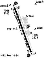
Runways
Runway Summary
| Runways: | 17/35 |
| Longest Runway: | 17/35 is 8002 ft (2439 m) long |
| Runways with an Instrument Approach: | 17, 35 |
AVL Airport Runway Details
| Runway 17/35 | 8002 ft x 150 ft (2439 m x 46 m) | |
| Runway Length Source: | 3RD PARTY SURVEY as of 11/11/2021 | |
| Surface: | Asphalt - Excellent condition - Saw-cut or plastic grooved | |
| Runway Edge Lights: | High Intensity | |
Runway Weight Bearing Capacity (in thousands of pounds) |
||
| Single Wheel Landing Gear: | 120.0 | |
| Dual Wheel Landing Gear: | 219.0 | |
| Dual Tandem Wheel Landing Gear: | 404.0 | |
| Dual Dual Tandem Wheel Landing Gear: | 837.0 | |
Runway 17 |
Runway 35 |
|
Elevation: |
2163.9 | 2117.4 |
Latitude: |
35-26-47.1443N | 35-25-32.8683N |
Longitude: |
082-32-48.0475W | 082-32-14.6990W |
|
Runway True Alignment: |
160 | 340 |
ILS Type: |
ILS/DME | ILS/DME |
Glide Path Angle: |
3.0 degrees | 3.0 degrees |
Traffic Pattern: |
Left | Right |
Runway Markings Type: |
Precision Instrument | Precision Instrument |
Runway Markings Condition: |
Good | Good |
Visual Glide Slope Indicators: |
4-Light PAPI On Right Side Of Runway | 4-Light PAPI On Left Side Of Runway |
Runway Visual Range (RVR): |
Touchdown, Rollout | Touchdown, Rollout |
Approach Light System: |
1,400 Foot Medium Intensity Approach Lighting System With Runway Alignment Indicator Lights | 1,400 Foot Medium Intensity Approach Lighting System With Runway Alignment Indicator Lights |
REIL: |
No | No |
Touchdown Lights: |
No | Yes |
Centerline Lights: |
Yes | Yes |
Threshold Crossing Height: |
55 | 56 |
Declared Distances |
||
Take Off Run Avbl. (TORA): |
8002 | 8002 |
Take Off Distance Avbl. (TODA): |
8002 | 8002 |
Actual Stop Dist. Avbl. (ASDA): |
8002 | 8002 |
Landing Dist. Avbl. (LDA): |
8002 | 8002 |
Services
Airframe Repair: |
Major |
Powerplant Repair: |
Major |
Bottled Oxygen: |
None |
Bulk Oxygen: |
None |
Fuel Available: |
100LL, Jet A |
Landing Fees: |
No |
Parking: |
Tiedowns available |
Ratings and Reviews
Write a review for Asheville Regional Airport
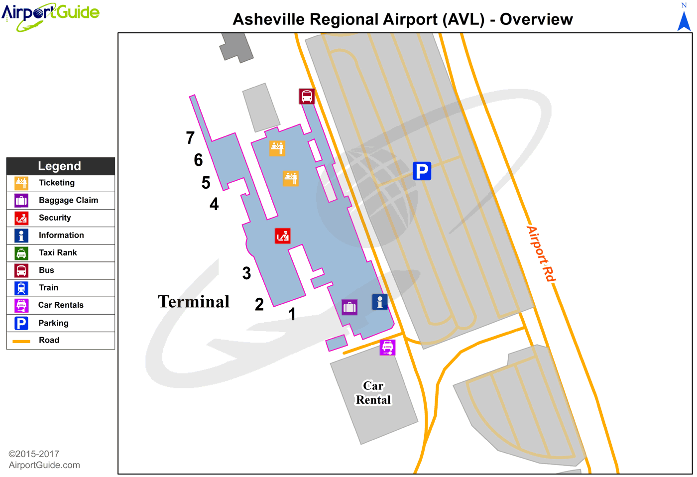
Maps & Diagrams
AVL Sectional
Flight Planning
at skyvector.com
at skyvector.com