Location
Latitude: |
38-01-49.5000N (38.030417) |
Longitude: |
120-24-52.4000W (-120.414556) |
Elevation: |
2120.7 feet MSL (646 m MSL) |
Magnetic Variation: |
12.8 E (as of April 2024 from WMM2020 model) |
Time Zone: |
UTC -8.0 (Standard Time) UTC -7.0 (Daylight Savings Time) |
From City: |
01 N.M. SW of Columbia, California |
Found On: |
San Francisco Chart |
FAA Region: |
AWP |
Contacts
Manager: |
Publicly owned: |
| KIM MACFARLANE 10723 AIRPORT RD COLUMBIA, CA 95310 (209) 533-6684 |
COUNTY OF TUOLUMNE 2 SOUTH GREEN ST. SONORA, CA 95370 209-533-5685 |
Operations
Airport Status: |
Operational |
Facility Use: |
Public |
Type: |
Airport |
Activation Date: |
04/1940 |
Control tower: |
No |
Attendance (Months/Days/Hours): |
Months/Days/Hours ALL/ALL/0800-1700 |
Boundary ARTCC: |
ZOA (Oakland) |
Responsible ARTCC: |
ZOA (Oakland) |
Lighting Schedule: |
SEE RMK |
Segmented Circle Indicator: |
Yes |
Traffic Pattern Altitude (MSL): |
3121 feet (951 m) |
NOTAMs Facility: |
RIU |
NOTAM-D Service: |
Yes |
International Airport of Entry: |
No |
Customs Landing Rights: |
No |
Military Landing Rights: |
Yes |
Civil/Military Joint Use: |
No |
Based Aircraft
| Single Engine: | 95 |
| Multi Engine: | 7 |
| GA Helicopters: | 1 |
Annual Operations (as of 06/25/2019)
| Total Operations: | 45657 | |
| Air Taxi: | 1740 | 3.8% |
| GA Local: | 21000 | 46.0% |
| GA Itinerant: | 22900 | 50.2% |
| Military Aircraft: | 17 | 0.0% |
Communications
| CTAF: | 122.975 |
| Unicom: | 122.975 |
| Approach: | NORCAL 125.1 ;WEST-NORTH 125.1 ;WEST-NORTH |
| Departure: | NORCAL 125.1 ;WEST-NORTH 125.1 ;WEST-NORTH |
| AWOS-3: | 124.65 (209-536-9384) |
- APCH/DEP CTL SVC PRVDD BY OAKLAND ARTCC (ZOA) ON FREQUENCY SECTORIZATION: EAST/SOUTH FREQUENCY 121.25/327.0/322.55 (ANGELS CAMP RCAG).
Fixed Based Operators (FBOs) & Fuel
(Click on a business for detail)
Please help us keep this information up to date. This is a FREE SERVICE just like everything else on Airport Guide! If you see that a business needs to be added, modified, or deleted please fill out our Update Form.
To add, modify, or delete a business click here.
Please help us keep this information up to date. This is a FREE SERVICE just like everything else on Airport Guide! If you see that a business needs to be added, modified, or deleted please fill out our Update Form.
Area Code: 209 |
| Business Name | Frequency | Phone | Fuel Grade |
|---|---|---|---|
| Air Yosemite
Update FBO info |
532-3855 | ||
| Bald Eagle Aviation
Update FBO info |
Unicom 123.05 | 533-4616, in emergency call 532-9167 | 100LL, Jet A |
| Courtney Aviation
Update FBO info |
532-2345 | ||
| Intermountain Helicopter
Update FBO info |
533-4374 | ||
| Mountain Aire Aviation
Update FBO info |
532-4011, after hours call 532-0359 | ||
| Sierra Upholstery
Update FBO info |
533-2536 | ||
| Springfield Flying Service
Update FBO info |
532-4103 |
Flight Service Stations
| Primary | Alternate | |
| FSS on Field: | N | |
| FSS Name (ID): | Rancho Murieta(RIU) | |
| Frequency: | ||
| Toll Free Phone: | 1-800-WX-BRIEF |
Instrument Procedures / Charts
FAA Terminal Procedures valid from 0901Z 03/21/24 to 0901Z 04/18/24.
There are various types of charts available for an airport. They are listed in the Page Type column. Here is a legend for those types:
APD - Airport Diagram
DP - Departure Procedure Charts
HOT - Hot Spots
IAP - Instrument Approach Procedure Charts
MIN - Minimums
STAR - Standard Terminal Arrival Charts
| Page Type | Page Name | Volume | Action Since Last Cycle |
|---|---|---|---|
| IAP | RNAV (GPS) RWY 35 | SW-2 | |
| MIN | ALTERNATE MINIMUMS | SW-2 | |
| MIN | TAKEOFF MINIMUMS | SW-2 | |
| ODP | FICHU FOUR (OBSTACLE) (RNAV) | SW-2 |
Terminal Procedures are only available for airports in several countries with more being added all the time. If you are looking for a specific country's charts, please send an email to support(at)airportguide.com stating the country name. This will be used to prioritize the implementation.
Navigation Aids (Navaids) near COA
| Dist (NM) | ID | Morse Code | Name | Type | Freq | True Hdg | Mag Hdg |
|---|---|---|---|---|---|---|---|
| 28.0 | LIN | . _ . . . . _ . | Linden | VOR-DME | 114.80 | 275 | 262 |
| 35.3 | MOD | _ _ _ _ _ _ . . | Modesto | VOR-DME | 114.60 | 226 | 213 |
| 37.7 | ECA | . _ . _ . . _ | Manteca | VOR-DME | 116.00 | 251 | 238 |
| 44.5 | HNW | . . . . _ . . _ _ | Hangtown | VOR-DME | 115.50 | 339 | 326 |
| 48.7 | HYP | . . . . _ . _ _ . _ _ . | El Nido | VOR-DME | 114.20 | 179 | 166 |
| 52.8 | TCY | _ _ . _ . _ . _ _ | Tracy | NDB | 203 | 247 | 234 |
| 58.4 | SAC | . . . . _ _ . _ . | Sacramento Executive | VOT | 111.40 | 299 | 286 |
| 59.0 | SAC | . . . . _ _ . _ . | Sacramento | VORTAC | 115.20 | 295 | 282 |
| 60.2 | MCC | _ _ _ . _ . _ . _ . | Mc Clellan | VOR-DME | 109.20 | 309 | 296 |
| 63.5 | LV | . _ . . . . . _ | Reiga | NDB | 374 | 251 | 238 |
| 67.9 | FRA | . . _ . . _ . . _ | Friant | VORTAC | 115.60 | 144 | 131 |
| 68.1 | SMF | . . . _ _ . . _ . | Sacramento Intl | VOT | 111.40 | 305 | 292 |
| 68.5 | TZZ | _ _ _ . . _ _ . . | Travis | VOR | 116.40 | 286 | 273 |
| 69.3 | SWR | . . . . _ _ . _ . | Squaw Valley | VOR-DME | 113.20 | 5 | 352 |
| 73.4 | SUU | . . . . . _ . . _ | Travis | TACAN | 116.60 | 280 | 267 |
| 74.5 | CZQ | _ . _ . _ _ . . _ _ . _ | Clovis | TACAN | 112.90 | 157 | 144 |
| 76.5 | CC | _ . _ . _ . _ . | Kanan | NDB | 335 | 271 | 258 |
| 77.1 | CCR | _ . _ . _ . _ . . _ . | Concord | VOR-DME | 117.00 | 271 | 258 |
| 80.8 | PXN | . _ _ . _ . . _ _ . | Panoche | VORTAC | 112.60 | 192 | 179 |
| 81.9 | BAB | _ . . . . _ _ . . . | Beale | TACAN | 108.60 | 324 | 311 |
Nearby Airports with Fuel
Notices to Airmen (NOTAMS)
Remarks
| A110-1 | CALFIRE AIR TANKER OPRS FM ARPT DRG FIRE SEASON. |
| A110-10 | LANDING FEE FOR ALL COMMERCIAL OPERATORS REGARDLESS OF SIZE & CORPORATE ACFT OVER 12500 LBS GROSS LANDING WEIGHT. |
| A110-12 | HEL PRKNG AREA 300 FT BY 120 FT (4 POSITIONS). |
| A110-13 | AVOID FLIGHTS OVER COLUMBIA STATE PARK NE OF ARPT, AND HWY 49 BRIDGE 5 NM SW OF ARPT & VICINITY. |
| A110-14 | FOR CD CTC NORCAL APCH AT 916-361-0516. |
| A110-2 | VARYING WIND DIRECTION & VELOCITY MAY BE ENCOUNTERED AT MID POINT OF RY 17/35 DUE TO TERRAIN FEATURES & WIND FLOW PATTERNS. |
| A110-6 | RY 11 DEPS PROHIBITED DUE TO CONFLICT WITH MAIN RY. |
| A110-7 | TURF TWY NORTH SIDE OF RY 11/29 NOT RECOMMENDED FOR USE NOV - MAR |
| A110-8 | RY 29 NOT RECOMMENDED FOR USE DURING WINTER MONTHS NOV THROUGH MAR. |
| A110-9 | ALL JET ACFT ARE REQUESTED TO LAND RY 35 & DEPART RY 17 WIND & WEATHER PERMITTING. |
| A31-17/35 | RY END SAFETY AREAS NSTD LENGTH; RY 17 210 FT; RY 35 300 FT. |
| A43-35 | RY 35 VASI UNUSABLE BYD 5 DEG LEFT AND RIGHT OF RY CNTRLN. |
| A57-17 | APCH RATIO FM DSPLCD THLD 31:1. |
| A57-35 | APCH RATIO FM DSPLCD THLD 37:1. |
| A80 | ARPT HAS TWO ROTG BCNS; ONE ON THE ARPT AND ONE 6500' SE THR RWY 35. |
| A81-APT | ACTVT MIRL RY 17/35 & REIL RYS 17 & 35 - CTAF. VASI RY 17 & RY 35 OPER CONTINUOUSLY. |
| E147 | TPA RWY 11/29 800 FT AGL. |
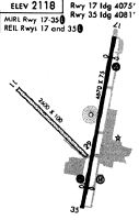
Runways
Runway Summary
| Runways: | 11/29 17/35 |
| Longest Runway: | 17/35 is 4673 ft (1424 m) long |
| Runways with an Instrument Approach: |
COA Airport Runway Details
| Runway 11/29 | 2607 ft x 50 ft (795 m x 15 m) | |
| Runway Length Source: | 3RD PARTY SURVEY as of 08/20/2010 | |
| Surface: | Turf - Good condition - No special surface treatment | |
Runway 11 |
Runway 29 |
|
Elevation: |
2100.6 | 2077.6 |
Latitude: |
38-01-58.8649N | 38-01-41.0903N |
Longitude: |
120-25-13.8617W | 120-24-50.2743W |
|
Runway True Alignment: |
134 | 314 |
Glide Path Angle: |
0.0 degrees | 0.0 degrees |
Traffic Pattern: |
Right | Left |
Runway Markings Type: |
None | Numbers Only |
Runway Markings Condition: |
Good | |
Object at End: |
TREES | TREES |
Object Height: |
135 | 115 |
Distance from End: |
2190 | 1600 |
Object Centerline Offset: |
125 ft. left of centerline | 100 ft. right of centerline |
REIL: |
No | No |
Touchdown Lights: |
No | No |
Centerline Lights: |
No | No |
| Runway 17/35 | 4673 ft x 75 ft (1424 m x 23 m) | |
| Runway Length Source: | 3RD PARTY SURVEY as of 08/20/2010 | |
| Surface: | Turf - Good condition - No special surface treatment | |
| Runway Edge Lights: | Medium Intensity | |
Runway Weight Bearing Capacity (in thousands of pounds) |
||
| Single Wheel Landing Gear: | 30.0 | |
Runway 17 |
Runway 35 |
|
Elevation: |
2120.7 | 2073.6 |
Latitude: |
38-02-12.0276N | 38-01-26.5676N |
Longitude: |
120-24-41.8439W | 120-24-52.1590W |
|
Runway True Alignment: |
190 | 010 |
Glide Path Angle: |
4.5 degrees | 4.0 degrees |
Traffic Pattern: |
Right | Left |
Runway Markings Type: |
Nonprecision Instrument | Nonprecision Instrument |
Runway Markings Condition: |
Fair | Fair |
Object at End: |
GND | TREES |
Object Height: |
33 | 61 |
Distance from End: |
450 | 1700 |
Object Centerline Offset: |
125 ft. left of centerline | 100 ft. right of centerline |
Visual Glide Slope Indicators: |
2-Box VASI On Left Side Of Runway | 2-Box VASI On Left Side Of Runway |
REIL: |
Yes | Yes |
Touchdown Lights: |
No | No |
Centerline Lights: |
No | No |
Threshold Crossing Height: |
56 | 54 |
Threshold Elevation: |
2112.2 | 2073.5 |
Displaced Threshold: |
598 | 384 |
Threshold Latitude: |
38-02-06.2087N | 38-01-30.3028N |
Threshold Longitude: |
120-24-43.1654W | 120-24-51.3281W |
Services
Airframe Repair: |
None |
Powerplant Repair: |
None |
Bottled Oxygen: |
None |
Bulk Oxygen: |
None |
Fuel Available: |
100LL |
Landing Fees: |
No |
Parking: |
Tiedowns available |
Other Services: |
Call for fuel service from phone in lounge |
Maps & Diagrams
COA Sectional
Flight Planning
at skyvector.com
at skyvector.com