Location
Latitude: |
38-53-38.0000N (38.893889) |
Longitude: |
119-59-43.2000W (-119.995333) |
Elevation: |
6268.4 feet MSL (1911 m MSL) |
Magnetic Variation: |
12.9 E (as of April 2024 from WMM2020 model) |
Time Zone: |
UTC -8.0 (Standard Time) UTC -7.0 (Daylight Savings Time) |
From City: |
03 N.M. SW of South Lake Tahoe, California |
Found On: |
San Francisco Chart |
FAA Region: |
AWP |
Contacts
Manager: |
Publicly owned: |
| JOHN DICKINSON 1901 LISA MALOFF WAY, SUITE 100 SOUTH LAKE TAHOE, CA 96150 530-542-6182 |
SOUTH LAKE TAHOE 1901 LISA MALOFF WAY, SUITE 100 SOUTH LAKE TAHOE, CA 96150 530-542-6182 |
Operations
Airport Status: |
Operational |
Facility Use: |
Public |
Type: |
Airport |
Control tower: |
No |
Attendance (Months/Days/Hours): |
Months/Days/Hours ALL/ /0700-1600 |
Boundary ARTCC: |
ZOA (Oakland) |
Responsible ARTCC: |
ZOA (Oakland) |
Lighting Schedule: |
SEE RMK |
Segmented Circle Indicator: |
Yes |
Traffic Pattern Altitude (MSL): |
7268 feet (2215 m) |
NOTAMs Facility: |
TVL |
NOTAM-D Service: |
Yes |
International Airport of Entry: |
No |
Customs Landing Rights: |
No |
Military Landing Rights: |
Yes |
Civil/Military Joint Use: |
No |
Based Aircraft
| Single Engine: | 18 |
| Multi Engine: | 1 |
| GA Helicopters: | 2 |
Annual Operations (as of 12/31/2023)
| Total Operations: | 9845 | |
| Commercial: | 207 | 2.1% |
| Air Taxi: | 657 | 6.7% |
| GA Local: | 646 | 6.6% |
| GA Itinerant: | 8099 | 82.3% |
| Military Aircraft: | 236 | 2.4% |
Communications
| CTAF: | 122.850 |
| ASOS: | 124.725 (530-541-5739) |
- APCH/DEP CTL SVC PRVDD BY OAKLAND ARTCC (ZOA) ON FREQ 127.95 (SQUAW VALLEY RCAG) AND FREQ 316.1 (SACRAMENTO RCAG). CLNC DEL PRVDD BY OAKLAND ARTCC ON FREQ 134.3 (SOUTH LAKE TAHOE RCAG).
- COMMUNICATIONS PRVDD BY RENO RADIO ON FREQ 122.5 (SQUAW VALLEY RCO).
Fixed Based Operators (FBOs) & Fuel
(Click on a business for detail)
Please help us keep this information up to date. This is a FREE SERVICE just like everything else on Airport Guide! If you see that a business needs to be added, modified, or deleted please fill out our Update Form.
To add, modify, or delete a business click here.
Please help us keep this information up to date. This is a FREE SERVICE just like everything else on Airport Guide! If you see that a business needs to be added, modified, or deleted please fill out our Update Form.
Area Code: 530 |
| Business Name | Frequency | Phone | Fuel Grade |
|---|---|---|---|
| Alpine Lake Aviation
Update FBO info |
800-251-4748 | ||
| Emerald Bay Aviation
Update FBO info |
542-0402 | ||
| Oasis Aviation
Update FBO info |
Unicom 122.95 | 541-2110 | 100LL, Jet A |
Flight Service Stations
| Primary | Alternate | |
| FSS on Field: | N | |
| FSS Name (ID): | Reno(RNO) | |
| Frequency: | ||
| Toll Free Phone: | 1-800-WX-BRIEF |
Instrument Procedures / Charts
FAA Terminal Procedures valid from 0901Z 03/21/24 to 0901Z 04/18/24.
There are various types of charts available for an airport. They are listed in the Page Type column. Here is a legend for those types:
APD - Airport Diagram
DP - Departure Procedure Charts
HOT - Hot Spots
IAP - Instrument Approach Procedure Charts
MIN - Minimums
STAR - Standard Terminal Arrival Charts
| Page Type | Page Name | Volume | Action Since Last Cycle |
|---|---|---|---|
| APD | AIRPORT DIAGRAM | SW-2 | |
| DP | RICHY SEVEN | SW-2 | |
| IAP | LDA RWY 18 | SW-2 | |
| IAP | RNAV (GPS) RWY 18 | SW-2 | Changed |
| MIN | TAKEOFF MINIMUMS | SW-2 |
Terminal Procedures are only available for airports in several countries with more being added all the time. If you are looking for a specific country's charts, please send an email to support(at)airportguide.com stating the country name. This will be used to prioritize the implementation.
Navigation Aids (Navaids) near TVL
| Dist (NM) | ID | Morse Code | Name | Type | Freq | True Hdg | Mag Hdg |
|---|---|---|---|---|---|---|---|
| 21.4 | SWR | . . . . _ _ . _ . | Squaw Valley | VOR-DME | 113.20 | 323 | 310 |
| 36.7 | HNW | . . . . _ . . _ _ | Hangtown | VOR-DME | 115.50 | 254 | 241 |
| 41.4 | FMG | . . _ . _ _ _ _ . | Mustang | VORTAC | 117.90 | 22 | 9 |
| 59.6 | HZN | . . . . _ _ . . _ . | Hazen | VORTAC | 114.10 | 50 | 37 |
| 67.3 | MCC | _ _ _ . _ . _ . _ . | Mc Clellan | VOR-DME | 109.20 | 258 | 245 |
| 67.7 | NFL | _ . . . _ . . _ . . | Fallon | TACAN | 113.50 | 61 | 48 |
| 68.3 | LIN | . _ . . . . _ . | Linden | VOR-DME | 114.80 | 224 | 211 |
| 68.9 | BAB | _ . . . . _ _ . . . | Beale | TACAN | 108.60 | 282 | 269 |
| 73.9 | SAC | . . . . _ _ . _ . | Sacramento Executive | VOT | 111.40 | 252 | 239 |
| 74.6 | MYV | _ _ _ . _ _ . . . _ | Marysville | VOR-DME | 110.80 | 279 | 266 |
| 75.6 | SMF | . . . _ _ . . _ . | Sacramento Intl | VOT | 111.40 | 261 | 248 |
| 77.0 | MY | _ _ _ . _ _ | Halow | NDB | 222 | 282 | 269 |
| 77.8 | SAC | . . . . _ _ . _ . | Sacramento | VORTAC | 115.20 | 250 | 237 |
| 82.8 | AHC | . _ . . . . _ . _ . | Amedee | VOR-DME | 109.00 | 355 | 342 |
| 84.3 | ECA | . _ . _ . . _ | Manteca | VOR-DME | 116.00 | 221 | 208 |
| 88.5 | MOD | _ _ _ _ _ _ . . | Modesto | VOR-DME | 114.60 | 211 | 198 |
| 91.3 | TZZ | _ _ _ . . _ _ . . | Travis | VOR | 116.40 | 249 | 236 |
| 93.9 | MVA | _ _ . . . _ . _ | Mina | VORTAC | 115.10 | 101 | 88 |
| 95.4 | ILA | . . . _ . . . _ | Williams | VORTAC | 114.40 | 277 | 264 |
| 98.8 | LLC | . _ . . . _ . . _ . _ . | Lovelock | VORTAC | 116.50 | 41 | 28 |
Nearby Airports with Fuel
Notices to Airmen (NOTAMS)
Remarks
| A110-1 | AP SFC CONDS: TRML APRON EXCELLENT, TWY - RWY GOOD, NORTH GA APRON POOR. |
| A110-12 | AFTER WINTER STORMS RY 18/36 OPENS BEFORE ALL TWYS ARE CLEAR. |
| A110-14 | PREFERRED ARRIVAL RY 18; PREFERRED DEP RY 36. |
| A110-18 | RECREATIONAL AIRBORNE ACTIVITY ALONG SOUTHERN LAKE SHORE. |
| A110-25 | (E81) APRON ENTRANCE TWYS AND HIGH SPEED TWYS ONLY. |
| A110-26 | FOR LARGE AND HIGH PERFORMANCE ACFT DEP RY 18; RIGHT DOWNWIND DEP RECOMMENDED. |
| A110-27 | BIRDS AND WATERFOWL INVOF ARPT. |
| A110-28 | ADVERSE WEATHER EFFECTS MAGNIFIED BY MOUNTAINS. |
| A110-29 | TFC ADVISORIES & SEQUENCING IN THE TFC PAT ARE BASED ON POSITION REPORTS RECEIVED FROM PILOTS IN THESE AREAS. |
| A110-31 | ARPT SURROUNDED ON E; S & W BY RAPIDLY RISING TERRAIN. |
| A110-32 | ACCESS NOISE RESTRICTIONS: MAX 80 DBA DEP, 84 DBA ARR (TRANSPORT - 86 DBA), MAX 77.1 DBA NIGHT LIMIT. |
| A110-33 | NOISE ABATEMENT, DEP RWY 36 HDG 1 MILE, LEFT 320 DEG TO SHORELINE. |
| A110-34 | FOR NOISE ABATEMENT INFO CALL (530) 542-6182. |
| A110-35 | AVOID DESOLATION WILDERNESS WEST OF ARPT. |
| A110-38 | AP CONDS NOT MMT 1600-0700 DLY. |
| A110-39 | TWY H CLSD PERM. |
| A110-4 | TPA 7500' MSL FOR SMALL ACFT; 8000' MSL FOR TRANSPORT/HIGH PERFORMANCE ACFT. |
| A110-40 | PARAGLIDERS AND MOTORIZED PRCHTS OPR FROM RWY SFC. |
| A110-41 | AP CONDS NOT MNT SAT/SUN. |
| A110-42 | COLD TEMPERATURE AIRPORT. ALTITUDE CORRECTION REQUIRED AT OR BELOW -13C. |
| A43-18 | UNUSBL BYD 2 DEG LEFT OF RWY CNTRLN & BYD 3 NM. |
| A57-36 | APCH RATIO 22:1 TO DSPLCD THLD. |
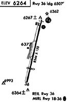
| A81-APT | ACTVT MALSF RWY 18; PAPI RWY 18, MIRL RW 18/36 - CTAF. |
| A82 | MULTICOM 122.85 |
Runways
Runway Summary
| Runways: | 18/36 |
| Longest Runway: | 18/36 is 8541 ft (2603 m) long |
| Runways with an Instrument Approach: | 18 |
TVL Airport Runway Details
| Runway 18/36 | 8541 ft x 100 ft (2603 m x 30 m) | |
| Runway Length Source: | 3RD PARTY SURVEY as of 08/04/2016 | |
| Surface: | Asphalt - Excellent condition - Saw-cut or plastic grooved | |
| Runway Edge Lights: | Medium Intensity | |
Runway Weight Bearing Capacity (in thousands of pounds) |
||
| Single Wheel Landing Gear: | 70.0 | |
| Dual Wheel Landing Gear: | 125.0 | |
| Dual Tandem Wheel Landing Gear: | 210.0 | |
Runway 18 |
Runway 36 |
|
Elevation: |
6254.6 | 6268.3 |
Latitude: |
38-54-19.1610N | 38-52-56.8980N |
Longitude: |
119-59-31.1510W | 119-59-55.2871W |
|
Runway True Alignment: |
193 | 013 |
ILS Type: |
LDA/DME | |
Glide Path Angle: |
3.0 degrees | 0.0 degrees |
Traffic Pattern: |
Left | Right |
Runway Markings Type: |
Nonprecision Instrument | Basic |
Runway Markings Condition: |
Good | Good |
Object at End: |
BRUSH | TREES |
Object Height: |
13 | 345 |
Distance from End: |
450 | 5700 |
Object Centerline Offset: |
125 ft. left of centerline | 500 ft. right of centerline |
Visual Glide Slope Indicators: |
4-Light PAPI On Left Side Of Runway | |
Approach Light System: |
1,400 Foot Medium Intensity Approach Lighting System With Sequenced Flashers | |
REIL: |
No | Yes |
Touchdown Lights: |
No | No |
Centerline Lights: |
No | No |
Threshold Crossing Height: |
48 | |
Threshold Elevation: |
6255.4 | 6263.4 |
Displaced Threshold: |
800 | 2033 |
Threshold Latitude: |
38-54-11.4573N | 38-53-16.4818N |
Threshold Longitude: |
119-59-33.4118W | 119-59-49.5417W |
Declared Distances |
||
Take Off Run Avbl. (TORA): |
8541 | 8541 |
Take Off Distance Avbl. (TODA): |
8541 | 8541 |
Actual Stop Dist. Avbl. (ASDA): |
7817 | 7741 |
Landing Dist. Avbl. (LDA): |
7017 | 5708 |
Services
Airframe Repair: |
Major |
Powerplant Repair: |
Major |
Bottled Oxygen: |
None |
Bulk Oxygen: |
None |
Fuel Available: |
100LL, Jet A |
Landing Fees: |
No |
Parking: |
Tiedowns available |
Maps & Diagrams
TVL Sectional
Flight Planning
at skyvector.com
at skyvector.com