Location
Latitude: |
38-33-19.1190N (38.555311) |
Longitude: |
121-17-49.9610W (-121.297211) |
Elevation: |
98.3 feet MSL (30 m MSL) |
Magnetic Variation: |
13 E (as of April 2024 from WMM2020 model) |
Time Zone: |
UTC -8.0 (Standard Time) UTC -7.0 (Daylight Savings Time) |
From City: |
10 N.M. E of Sacramento, California |
Found On: |
San Francisco Chart |
FAA Region: |
AWP |
Contacts
Manager: |
Publicly owned: |
| LARRY FLESHMAN 10425 NORDEN AVE MATHER, CA 95655 916-875-6760 |
COUNTY OF SACRAMENTO 6900 AIRPORT BLVD. SACRAMENTO, CA 95837 916-875-7077 |
Operations
Airport Status: |
Operational |
Facility Use: |
Public |
Type: |
Airport |
Activation Date: |
07/1942 |
Control tower: |
Yes |
Attendance (Months/Days/Hours): |
Months/Days/Hours ALL/MON/0500-2330 |
Boundary ARTCC: |
ZOA (Oakland) |
Responsible ARTCC: |
ZOA (Oakland) |
Lighting Schedule: |
SEE RMK |
Segmented Circle Indicator: |
No |
Traffic Pattern Altitude (MSL): |
1098 feet (335 m) |
NOTAMs Facility: |
MHR |
NOTAM-D Service: |
Yes |
International Airport of Entry: |
No |
Customs Landing Rights: |
No |
Military Landing Rights: |
Yes |
Based Aircraft
| Single Engine: | 10 |
| Multi Engine: | 1 |
| Military Aircraft: | 41 |
Annual Operations (as of 12/31/2018)
| Total Operations: | 99467 | |
| Commercial: | 4781 | 4.8% |
| Air Taxi: | 12493 | 12.6% |
| GA Local: | 13713 | 13.8% |
| GA Itinerant: | 36778 | 37.0% |
| Military Aircraft: | 31702 | 31.9% |
Communications
| CTAF: | 120.650 |
| Unicom: | 122.950 |
| Tower: | MATHER 120.65 282.25 Hrs: MON 0500-2330, TUE-FRI 0300-2330, SAT 0300-2100, SUN 0500-2100 |
| Clearance Del.: | 121.85 307.9 |
| Ground: | 121.85 307.9 |
| Approach: | NORCAL 127.4 127.4 127.4 |
| Departure: | NORCAL 127.4 127.4 127.4 |
| ATIS: | 118.325 Hrs: 24 |
| AWOS-3PT: | 118.325 (916-366-3371) |
- ATCT OPER BY SERCO.
- COMMUNICATIONS PRVDD BY RANCHO MURIETA RADIO ON FREQ 122.4 (SACRAMENTO RCO).
Fixed Based Operators (FBOs) & Fuel
(Click on a business for detail)
Please help us keep this information up to date. This is a FREE SERVICE just like everything else on Airport Guide! If you see that a business needs to be added, modified, or deleted please fill out our Update Form.
To add, modify, or delete a business click here.
Please help us keep this information up to date. This is a FREE SERVICE just like everything else on Airport Guide! If you see that a business needs to be added, modified, or deleted please fill out our Update Form.
Area Code: 916 |
| Business Name | Frequency | Phone | Fuel Grade |
|---|---|---|---|
| Mather Aviation
Update FBO info |
364-4711 | ||
| Trajen Flight Support
Website Update FBO info |
Unicom 123.075, Arinc 130.55 | 368-1455 | 100LL, Jet A |

|
 Exxon Avitat |
100LL - 2.95 USD per gallon on 9/8/01 |
24 Hour Self-serve Credit Card Pumps All taxes included. |
|
|
Exxon Avitat |
Jet A - 2.74 USD per gallon on 9/8/01 |
24 Hour Self-serve Credit Card Pumps All taxes included. |
Flight Service Stations
| Primary | Alternate | |
| FSS on Field: | N | |
| FSS Name (ID): | Rancho Murieta(RIU) | |
| Frequency: | ||
| Toll Free Phone: | 1-800-WX-BRIEF |
Instrument Procedures / Charts
FAA Terminal Procedures valid from 0901Z 03/21/24 to 0901Z 04/18/24.
There are various types of charts available for an airport. They are listed in the Page Type column. Here is a legend for those types:
APD - Airport Diagram
DP - Departure Procedure Charts
HOT - Hot Spots
IAP - Instrument Approach Procedure Charts
MIN - Minimums
STAR - Standard Terminal Arrival Charts
| Page Type | Page Name | Volume | Action Since Last Cycle |
|---|---|---|---|
| APD | AIRPORT DIAGRAM | SW-2 | |
| IAP | ILS Y OR LOC Y RWY 22L | SW-2 | |
| IAP | ILS Z OR LOC Z RWY 22L | SW-2 | |
| IAP | ILS Z RWY 22L (SA CAT I - II) | SW-2 | |
| IAP | RNAV (GPS) RWY 04R | SW-2 | |
| IAP | RNAV (GPS) RWY 22L | SW-2 | |
| IAP | RNAV (GPS) RWY 22R | SW-2 | |
| MIN | ALTERNATE MINIMUMS | SW-2 | |
| MIN | TAKEOFF MINIMUMS | SW-2 | |
| STAR | AMRVR TWO (RNAV) | SW-2 |
Terminal Procedures are only available for airports in several countries with more being added all the time. If you are looking for a specific country's charts, please send an email to support(at)airportguide.com stating the country name. This will be used to prioritize the implementation.
Navigation Aids (Navaids) near MHR
| Dist (NM) | ID | Morse Code | Name | Type | Freq | True Hdg | Mag Hdg |
|---|---|---|---|---|---|---|---|
| 8.4 | MCC | _ _ _ . _ . _ . _ . | Mc Clellan | VOR-DME | 109.20 | 323 | 310 |
| 9.7 | SAC | . . . . _ _ . _ . | Sacramento Executive | VOT | 111.40 | 253 | 240 |
| 13.7 | SAC | . . . . _ _ . _ . | Sacramento | VORTAC | 115.20 | 240 | 227 |
| 16.0 | SMF | . . . _ _ . . _ . | Sacramento Intl | VOT | 111.40 | 300 | 287 |
| 27.3 | TZZ | _ _ _ . . _ _ . . | Travis | VOR | 116.40 | 242 | 229 |
| 27.6 | HNW | . . . . _ . . _ _ | Hangtown | VOR-DME | 115.50 | 68 | 55 |
| 32.0 | LIN | . _ . . . . _ . | Linden | VOR-DME | 114.80 | 154 | 141 |
| 35.1 | MYV | _ _ _ . _ _ . . . _ | Marysville | VOR-DME | 110.80 | 338 | 325 |
| 35.4 | BAB | _ . . . . _ _ . . . | Beale | TACAN | 108.60 | 349 | 336 |
| 35.7 | SUU | . . . . . _ . . _ | Travis | TACAN | 116.60 | 238 | 225 |
| 39.6 | MY | _ _ _ . _ _ | Halow | NDB | 222 | 338 | 325 |
| 43.7 | ECA | . _ . _ . . _ | Manteca | VOR-DME | 116.00 | 172 | 159 |
| 46.1 | ILA | . . . _ . . . _ | Williams | VORTAC | 114.40 | 312 | 299 |
| 46.2 | CC | _ . _ . _ . _ . | Kanan | NDB | 335 | 228 | 215 |
| 46.7 | CCR | _ . _ . _ . _ . . _ . | Concord | VOR-DME | 117.00 | 229 | 216 |
| 52.2 | TCY | _ _ . _ . _ . _ _ | Tracy | NDB | 203 | 187 | 174 |
| 54.9 | LV | . _ . . . . . _ | Reiga | NDB | 374 | 199 | 186 |
| 55.4 | SGD | . . . _ _ . _ . . | Scaggs Island | VORTAC | 112.10 | 246 | 233 |
| 57.9 | MOD | _ _ _ _ _ _ . . | Modesto | VOR-DME | 114.60 | 163 | 150 |
| 60.9 | SWR | . . . . _ _ . _ . | Squaw Valley | VOR-DME | 113.20 | 51 | 38 |
Nearby Airports with Fuel
Notices to Airmen (NOTAMS)
Remarks
| A110-10 | BE ADVISED RY 4L THLD LGTS ARE NON-STANDARD. |
| A110-11 | FOR CD WHEN ATCT IS CLSD CTC NORCAL APCH AT 916-361-6874. |
| A110-12 | TWY D1 CLSD TO ACFT WITH WINGSPAN MORE THAN 69 FT. |
| A110-2 | RY 22L CALM WIND RY. |
| A110-3 | BE ALERT FOR LARGE TRANSPORT ACFT TKOFS & LNDGS AND HIGH PERFORMANCE MILITARY T-38 JETS. |
| A110-5 | AVOID NOISE SENSITIVE RESIDENTIAL AREAS NORTH/EAST OF RY 22L ILS FINAL APCH COURSE. TURBOJET NIGHTTIME NOISE ABATEMENT ARRIVAL AND DEPARTURE PROCEDURES IN EFFECT 2200-0700 DAILY. |
| A110-6 | PILOT INFORMATION ON NOISE ABATEMENT (916) 874-0359. |
| A110-7 | TWY D LTD TO ACFT WITH MAX GWT 50000 LBS OR LESS. TWY D1 LTD TO ACFT WITH MAX GWT OF 50000 LBS OR LESS. |
| A110-8 | BIRDS INVOF OF ARPT. |
| A110-9 | ACFT ENTERING RY 22R TFC PAT FM THE NORTH SHOULD EXPECT TO FLY BASE LEG EXTENDED 2 MILES FM RY THLD. |
| A35-04R/22L | SWL 65/PSI 640. |
| A81-APT | WHEN ATCT CLSD ACTVT MIRL RY 04L/22R, HIRL RY 04R/22L, VASI RYS 04R, 22L AND MALSR RY 22L - CTAF. |
| E111 | NO OBJECTION |
| E147 | TPA FOR PISTON ACFT 1000 FT AGL; TURBINE ACFT 1800 FT AGL. |
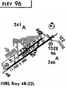
Runways
Runway Summary
| Runways: | 04L/22R 04R/22L H1 H2 |
| Longest Runway: | 04R/22L is 11301 ft (3445 m) long |
| Runways with an Instrument Approach: | 22L |
MHR Airport Runway Details
| Runway 04L/22R | 6081 ft x 150 ft (1853 m x 46 m) | |
| Runway Length Source: | 3RD PARTY SURVEY as of 12/22/2017 | |
| Surface: | Asphalt - Good condition - No special surface treatment | |
| Runway Edge Lights: | Medium Intensity | |
Runway Weight Bearing Capacity (in thousands of pounds) |
||
| Single Wheel Landing Gear: | 90.0 | |
| Dual Wheel Landing Gear: | 105.0 | |
| Dual Tandem Wheel Landing Gear: | 190.0 | |
Runway 04L |
Runway 22R |
|
Elevation: |
80.9 | 94.1 |
Latitude: |
38-33-10.7711N | 38-33-46.3502N |
Longitude: |
121-18-18.2550W | 121-17-16.5606W |
|
Runway True Alignment: |
054 | 234 |
Glide Path Angle: |
0.0 degrees | 0.0 degrees |
Traffic Pattern: |
Left | Right |
Runway Markings Type: |
Nonprecision Instrument | Nonprecision Instrument |
Runway Markings Condition: |
Good | Good |
REIL: |
No | No |
Touchdown Lights: |
No | No |
Centerline Lights: |
No | No |
| Runway 04R/22L | 11301 ft x 150 ft (3445 m x 46 m) | |
| Runway Length Source: | 3RD PARTY SURVEY as of 12/22/2017 | |
| Surface: | Asphalt - Good condition - No special surface treatment | |
| Runway Edge Lights: | High Intensity | |
Runway Weight Bearing Capacity (in thousands of pounds) |
||
| Single Wheel Landing Gear: | 160.0 | |
| Dual Wheel Landing Gear: | 280.0 | |
| Dual Tandem Wheel Landing Gear: | 500.0 | |
Runway 04R |
Runway 22L |
|
Elevation: |
77.3 | 98.3 |
Latitude: |
38-32-40.9734N | 38-33-47.0941N |
Longitude: |
121-18-48.6570W | 121-16-53.9950W |
|
Runway True Alignment: |
054 | 234 |
ILS Type: |
ILS/DME | |
Glide Path Angle: |
3.0 degrees | 3.0 degrees |
Traffic Pattern: |
Right | Left |
Runway Markings Type: |
Precision Instrument | Precision Instrument |
Runway Markings Condition: |
Good | Good |
Visual Glide Slope Indicators: |
4-Box VASI On Left Side Of Runway | 4-Box VASI On Left Side Of Runway |
Runway Visual Range (RVR): |
Touchdown, Midfield, Rollout | Touchdown, Midfield, Rollout |
Approach Light System: |
1,400 Foot Medium Intensity Approach Lighting System With Runway Alignment Indicator Lights | |
Touchdown Lights: |
No | No |
Centerline Lights: |
No | No |
Threshold Crossing Height: |
51 | 50 |
| Helipad H1 | 30 ft x 30 ft (9 m x 9 m) | |
| Runway Length Source: | STATE as of 02/22/2006 | |
| Surface: | Asphalt - Good condition - No special surface treatment | |
Helipad H1 |
||
Elevation: |
95.0 | |
Latitude: |
38-33-45.9800N | |
Longitude: |
121-17-29.0100W | |
Glide Path Angle: |
0.0 degrees | 0.0 degrees |
| Helipad H2 | 100 ft x 100 ft (30 m x 30 m) | |
| Surface: | Asphalt - Good condition - No special surface treatment | |
Helipad H2 |
||
Elevation: |
92.0 | |
Latitude: |
38-33-22.3600N | |
Longitude: |
121-17-07.8500W | |
Glide Path Angle: |
0.0 degrees | 0.0 degrees |
Services
Airframe Repair: |
Major |
Powerplant Repair: |
Major |
Fuel Available: |
100LL |
Landing Fees: |
No |
Parking: |
Tiedowns available |
Other Services: |
Aircraft modifications |
Maps & Diagrams
MHR Sectional
Flight Planning
at skyvector.com
at skyvector.com