Location
Latitude: |
30-31-58.5000N (30.532917) |
Longitude: |
091-08-59.6000W (-91.149889) |
Elevation: |
69.7 feet MSL (21 m MSL) |
Magnetic Variation: |
0.8 W (as of April 2024 from WMM2020 model) |
Time Zone: |
UTC -6.0 (Standard Time) UTC -5.0 (Daylight Savings Time) |
From City: |
04 N.M. N of Baton Rouge, Louisiana |
Found On: |
Houston Chart |
FAA Region: |
ASW |
Contacts
Manager: |
Publicly owned: |
| MIKE EDWARDS 9430 JACKIE COCHRAN DR. STE 300 BATON ROUGE, LA 70807 225-355-0333 |
EAST BATON ROUGE PARISH PO BOX 1471 BATON ROUGE, LA 70821 |
Operations
Airport Status: |
Operational |
Facility Use: |
Public |
Type: |
Airport |
Activation Date: |
06/1942 |
Control tower: |
Yes |
Attendance (Months/Days/Hours): |
Months/Days/Hours ALL/ALL/0500-0000 |
Boundary ARTCC: |
ZHU (Houston) |
Responsible ARTCC: |
ZHU (Houston) |
Lighting Schedule: |
SEE RMK |
Segmented Circle Indicator: |
Yes |
Traffic Pattern Altitude (MSL): |
1070 feet (326 m) |
NOTAMs Facility: |
BTR |
NOTAM-D Service: |
Yes |
International Airport of Entry: |
No |
Customs Landing Rights: |
Yes |
Military Landing Rights: |
Yes |
Civil/Military Joint Use: |
No |
Aircraft Rescue and Firefighting: |
Class I ARFF Index: C Air Carrier Service: Scheduled Certification Date: 05/1973 |
Based Aircraft
| Single Engine: | 98 |
| Multi Engine: | 28 |
| Jet Engine: | 27 |
| GA Helicopters: | 17 |
Annual Operations (as of 07/31/2023)
| Total Operations: | 49495 | |
| Commercial: | 8629 | 17.4% |
| Air Taxi: | 7213 | 14.6% |
| GA Local: | 14929 | 30.2% |
| GA Itinerant: | 17255 | 34.9% |
| Military Aircraft: | 1469 | 3.0% |
Communications
| CTAF: | 118.450 |
| Unicom: | 122.950 |
| Tower: | RYAN 118.45 257.8 Hrs: 0500-0000 |
| Clearance Del.: | 119.4 |
| Ground: | 121.9 |
| Approach: | BATON ROUGE 120.3 ;WEST 133.225 ;EAST 278.3 Hrs: 0500-0000 HOUSTON ARTCC Hrs: 0000-0500 |
| Departure: | BATON ROUGE 120.3 ;WEST 133.225 ;EAST 278.3 Hrs: 0500-0000 HOUSTON ARTCC Hrs: 0000-0500 |
| ATIS: | 125.2 Hrs: 24 |
| ASOS: | (225-354-2138) |
| EMERG: | 243.0 |
| CLASS C: | 120.3 ;WEST |
| CLASS C: | 278.3 |
| EMERG: | 121.5 |
| CLASS C: | 133.225 ;EAST |
- APCH/DEP SVC PRVDD BY HOUSTON ARTCC (ZHU) ON FREQS 126.35/338.25 (LACOMBE RCAG) WHEN BATON ROUGE (BTR) APCH CTL CLSD.
Fixed Based Operators (FBOs) & Fuel
(Click on a business for detail)
Please help us keep this information up to date. This is a FREE SERVICE just like everything else on Airport Guide! If you see that a business needs to be added, modified, or deleted please fill out our Update Form.
To add, modify, or delete a business click here.
Please help us keep this information up to date. This is a FREE SERVICE just like everything else on Airport Guide! If you see that a business needs to be added, modified, or deleted please fill out our Update Form.
Area Code: 504 |
| Business Name | Frequency | Phone | Fuel Grade |
|---|---|---|---|
| Capitol City Air Service, Inc.
Update FBO info |
356-9592 | 100LL, Jet A | |
| Louisiana Aircraft, Inc.
Update FBO info |
Arinc 129.3 | 356-1401 | 100LL, Jet A |
| PAI Aero
Update FBO info |
Arinc131.77 | 355-9052 | 100LL |
| Signature Flight Support
Update FBO info |
Arinc: 129.3 | +1 225 356 1401 |
Flight Service Stations
| Primary | Alternate | |
| FSS on Field: | N | |
| FSS Name (ID): | De Ridder(DRI) | |
| Frequency: | ||
| Toll Free Phone: | 1-800-WX-BRIEF |
Instrument Procedures / Charts
FAA Terminal Procedures valid from 0901Z 03/21/24 to 0901Z 04/18/24.
There are various types of charts available for an airport. They are listed in the Page Type column. Here is a legend for those types:
APD - Airport Diagram
DP - Departure Procedure Charts
HOT - Hot Spots
IAP - Instrument Approach Procedure Charts
MIN - Minimums
STAR - Standard Terminal Arrival Charts
| Page Type | Page Name | Volume | Action Since Last Cycle |
|---|---|---|---|
| APD | AIRPORT DIAGRAM | SC-4 | |
| HOT | HOT SPOT | SC-4 | |
| IAP | ILS OR LOC RWY 13 | SC-4 | |
| IAP | ILS OR LOC/DME RWY 22R | SC-4 | |
| IAP | ILS RWY 22R (SA CAT I - II) | SC-4 | |
| IAP | RNAV (GPS) RWY 04L | SC-4 | |
| IAP | RNAV (GPS) RWY 13 | SC-4 | |
| IAP | RNAV (GPS) RWY 22R | SC-4 | |
| IAP | RNAV (GPS) RWY 31 | SC-4 | |
| IAP | VOR RWY 04L | SC-4 | |
| MIN | ALTERNATE MINIMUMS | SC-4 | |
| MIN | RADAR MINIMUMS | SC-4 | |
| MIN | TAKEOFF MINIMUMS | SC-4 |
Terminal Procedures are only available for airports in several countries with more being added all the time. If you are looking for a specific country's charts, please send an email to support(at)airportguide.com stating the country name. This will be used to prioritize the implementation.
Navigation Aids (Navaids) near BTR
| Dist (NM) | ID | Morse Code | Name | Type | Freq | True Hdg | Mag Hdg |
|---|---|---|---|---|---|---|---|
| 4.4 | BT | _ . . . _ | Rundi | NDB | 284 | 313 | 314 |
| 8.0 | LSU | . _ . . . . . . . _ | Fighting Tiger | VORTAC | 116.50 | 248 | 249 |
| 18.5 | FWX | . . _ . . _ _ _ . . _ | New Roads | NDB | 356 | 289 | 290 |
| 37.9 | HMU | . . . . _ _ . . _ | Hammond | VOR | 109.60 | 91 | 92 |
| 37.9 | HP | . . . . . _ _ . | Anger | NDB | 212 | 83 | 84 |
| 39.5 | RQR | . _ . _ _ . _ . _ . | Reserve | VOR-DME | 110.80 | 132 | 133 |
| 41.9 | LF | . _ . . . . _ . | Laffs | NDB | 375 | 249 | 250 |
| 48.1 | LFT | . _ . . . . _ . _ | Lafayette | VORTAC | 109.80 | 245 | 246 |
| 49.4 | MS | _ _ . . . | Kinte | NDB | 338 | 127 | 128 |
| 49.6 | OPL | _ _ _ . _ _ . . _ . . | St Landry | NDB | 335 | 278 | 279 |
| 50.0 | PTN | . _ _ . _ _ . | Patterson | NDB | 245 | 191 | 192 |
| 50.6 | AR | . _ . _ . | Acadi | NDB | 269 | 227 | 228 |
| 54.4 | MC | _ _ _ . _ . | Ferni | NDB | 413 | 37 | 38 |
| 54.7 | TBD | _ _ . . . _ . . | Tibby | VOR-DME | 112.00 | 162 | 163 |
| 57.8 | BNZ | _ . . . _ . _ _ . . | Abbeville | NDB | 230 | 240 | 240 |
| 58.3 | MKV | _ _ _ . _ . . . _ | Marksville | NDB | 347 | 305 | 306 |
| 59.4 | BWK | _ . . . . _ _ _ . _ | Bunkie | NDB | 397 | 289 | 289 |
| 65.2 | MCB | _ _ _ . _ . _ . . . | Mc Comb | VORTAC | 116.70 | 44 | 45 |
| 65.6 | HEZ | . . . . . _ _ . . | Natchez | VOR-DME | 110.00 | 353 | 354 |
| 67.1 | ECY | . _ . _ . _ . _ _ | Duralde | NDB | 263 | 271 | 271 |
Nearby Airports with Fuel
Notices to Airmen (NOTAMS)
Remarks
| A11 | CITY OF BATON ROUGE AND PARISH OF EAST BATON ROUGE. |
| A110-1 | WHEN ATCT CLSD USE FREQ 121.9 TO CTC ARFF FOR EMERG REQ. |
| A110-10 | FOR CD IF UNA TO CTC ON FSS FREQ, CTC HOUSTON ARTCC AT 281-230-5622. |
| A110-11 | TWY E, TWY F BTN RWY 04R-22L AND AER 31 NOT AVBL FOR SKEDD ACR OPS. |
| A110-12 | TWY F BTN RWY 04R-22L AND AER 31 RDCS TO 40 FT WID. |
| A110-2 | MIGRATORY BIRDS ON & INVOF ARPT DURING MONTHS OF MAR/APR/SEP & OCT. |
| A110-4 | TWY E WEIGHT RESTRICTIONS: SINGLE 44,000 LBS; DUAL 55,000 LBS; DUAL TANDEM 93,000 LBS. |
| A110-5 | RAMP & TWY LANE ADJ TO THE COMMERICAL AIR CARRIER TERMINAL BLDG IS LMTD TO COMMERICAL AIR CARRIER AND PSGR AIRTAXI ACFT ONLY. |
| A110-8 | RWY 04R/22L NOT AVBL FOR ACR OPNS WITH MORE THAN 30 PSGR SEATS. |
| A110-9 | RWY 4R/22L AND TWY E ARE SIMILAR IN APPRNC. USE CTN WHEN EXITING RWY 13/31. |
| A26 | 24 HRS PPR FOR UNSKED ACR OPNS WITH MORE THAN 30 PSGR SEATS 0000-0500 CALL AMGR 225-355-2068/0333. |
| A57-31 | +68 FT TREE, 1578 FT, 516 RIGHT. |
| A58-13 | +7 FT FENCE 200 FT 406 FT LEFT. |
| A58-31 | +7 FT FENCE 200 FT 496 FT RIGHT. |
| A81-APT | ACTVT MALSR RYS 22R & 13 AND MALS RY 31 - CTAF. WHEN ATCT CLSD HIRL RYS 13/31 & 04L/22R PRESET LOW INTST; TO INCR INTST ACTVT - CTAF. MIRL RY 04R/22L NOT AVBL. |
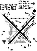
Runways
Runway Summary
| Runways: | 04L/22R 04R/22L 13/31 |
| Longest Runway: | 04L/22R is 7500 ft (2286 m) long |
| Runways with an Instrument Approach: | 22R, 13 |
BTR Airport Runway Details
| Runway 04L/22R | 7500 ft x 150 ft (2286 m x 46 m) | |
| Runway Length Source: | 3RD PARTY SURVEY as of 12/13/2015 | |
| Surface: | Concrete - Excellent condition - Saw-cut or plastic grooved | |
| Runway Pavement Class: | 70 /R/A/W/T | |
| Runway Edge Lights: | High Intensity | |
Runway Weight Bearing Capacity (in thousands of pounds) |
||
| Single Wheel Landing Gear: | 120.0 | |
| Dual Wheel Landing Gear: | 170.0 | |
| Dual Tandem Wheel Landing Gear: | 300.0 | |
Runway 04L |
Runway 22R |
|
Elevation: |
65.4 | 69.3 |
Latitude: |
30-31-28.3560N | 30-32-22.2316N |
Longitude: |
091-09-26.7065W | 091-08-27.7073W |
|
Runway True Alignment: |
043 | 223 |
ILS Type: |
ILS/DME | |
Glide Path Angle: |
0.0 degrees | 3.0 degrees |
Traffic Pattern: |
Left | Right |
Runway Markings Type: |
Nonprecision Instrument | Precision Instrument |
Runway Markings Condition: |
Good | Good |
Object at End: |
POLE | |
Object Height: |
52 | |
Object Marked/Lighted?: |
Lighted | |
Distance from End: |
2200 | |
Object Centerline Offset: |
125 ft. left of centerline | |
Visual Glide Slope Indicators: |
4-Light PAPI On Left Side Of Runway | |
Runway Visual Range (RVR): |
Touchdown, Rollout | Touchdown, Rollout |
Approach Light System: |
1,400 Foot Medium Intensity Approach Lighting System With Runway Alignment Indicator Lights | |
REIL: |
No | |
Touchdown Lights: |
No | Yes |
Centerline Lights: |
Yes | Yes |
Threshold Crossing Height: |
56 | |
Declared Distances |
||
Take Off Run Avbl. (TORA): |
7500 | 7500 |
Take Off Distance Avbl. (TODA): |
7500 | 7500 |
Actual Stop Dist. Avbl. (ASDA): |
7500 | 7500 |
Landing Dist. Avbl. (LDA): |
7500 | 7500 |
| Runway 04R/22L | 3799 ft x 75 ft (1158 m x 23 m) | |
| Runway Length Source: | 3RD PARTY SURVEY as of 12/13/2015 | |
| Surface: | Concrete - Excellent condition - No special surface treatment | |
| Runway Pavement Class: | 26 /F/C/X/T | |
| Runway Edge Lights: | Medium Intensity | |
Runway Weight Bearing Capacity (in thousands of pounds) |
||
| Single Wheel Landing Gear: | 30.0 | |
| Dual Wheel Landing Gear: | 45.0 | |
Runway 04R |
Runway 22L |
|
Elevation: |
66.5 | 68.3 |
Latitude: |
30-31-43.0831N | 30-32-10.3657N |
Longitude: |
091-08-59.5587W | 091-08-29.6667W |
|
Runway True Alignment: |
043 | 223 |
Glide Path Angle: |
3.0 degrees | 3.0 degrees |
Traffic Pattern: |
Right | |
Runway Markings Type: |
Basic | Basic |
Runway Markings Condition: |
Good | Good |
Object Centerline Offset: |
125 ft. left of centerline | |
Visual Glide Slope Indicators: |
2-Light PAPI On Left Side Of Runway | 2-Light PAPI On Left Side Of Runway |
Declared Distances |
||
Take Off Run Avbl. (TORA): |
3799 | 3799 |
Take Off Distance Avbl. (TODA): |
3799 | 3799 |
Actual Stop Dist. Avbl. (ASDA): |
3799 | 3799 |
Landing Dist. Avbl. (LDA): |
3799 | 3799 |
| Runway 13/31 | 7005 ft x 150 ft (2135 m x 46 m) | |
| Runway Length Source: | 3RD PARTY SURVEY as of 12/13/2015 | |
| Surface: | Concrete - Excellent condition - Saw-cut or plastic grooved | |
| Runway Pavement Class: | 95 /F/C/X/T | |
| Runway Edge Lights: | High Intensity | |
Runway Weight Bearing Capacity (in thousands of pounds) |
||
| Single Wheel Landing Gear: | 120.0 | |
| Dual Wheel Landing Gear: | 170.0 | |
| Dual Tandem Wheel Landing Gear: | 300.0 | |
Runway 13 |
Runway 31 |
|
Elevation: |
65.9 | 69.0 |
Latitude: |
30-32-26.6438N | 30-31-38.9445N |
Longitude: |
091-09-39.2383W | 091-08-41.1162W |
|
Runway True Alignment: |
133 | 313 |
ILS Type: |
ILS/DME | |
Glide Path Angle: |
0.0 degrees | 3.0 degrees |
Traffic Pattern: |
Left | Left |
Runway Markings Type: |
Precision Instrument | Nonprecision Instrument |
Runway Markings Condition: |
Good | Good |
Object at End: |
POLE | ROAD |
Object Height: |
76 | 11 |
Object Marked/Lighted?: |
Lighted | |
Distance from End: |
2345 | 230 |
Object Centerline Offset: |
125 ft. left of centerline | |
Visual Glide Slope Indicators: |
4-Box VASI On Left Side Of Runway | |
Runway Visual Range (RVR): |
Touchdown | Rollout |
Approach Light System: |
1,400 Foot Medium Intensity Approach Lighting System With Runway Alignment Indicator Lights | 1,400 Foot Medium Intensity Approach Lighting System |
Threshold Crossing Height: |
64 | |
Threshold Elevation: |
65.8 | 68.6 |
Displaced Threshold: |
597 | 314 |
Threshold Latitude: |
30-32-22.5789N | 30-31-41.0796N |
Threshold Longitude: |
091-09-34.2861W | 091-08-43.7177W |
Declared Distances |
||
Take Off Run Avbl. (TORA): |
7004 | 7004 |
Take Off Distance Avbl. (TODA): |
7004 | 7004 |
Actual Stop Dist. Avbl. (ASDA): |
6317 | 6407 |
Landing Dist. Avbl. (LDA): |
5720 | 6094 |
Services
Airframe Repair: |
Minor |
Powerplant Repair: |
Minor |
Bottled Oxygen: |
None |
Bulk Oxygen: |
None |
Fuel Available: |
100LL, Jet A, MOGAS |
Landing Fees: |
No |
Parking: |
Hangars and tiedowns available |
Maps & Diagrams
BTR Sectional
Flight Planning
at skyvector.com
at skyvector.com