Location
Latitude: |
30-33-30.2390N (30.5584) |
Longitude: |
092-05-57.7540W (-92.099376) |
Elevation: |
74.3 feet MSL (23 m MSL) |
Magnetic Variation: |
0.2 W (as of April 2024 from WMM2020 model) |
Time Zone: |
UTC -6.0 (Standard Time) UTC -5.0 (Daylight Savings Time) |
From City: |
02 N.M. NW of Opelousas, Louisiana |
Found On: |
Houston Chart |
FAA Region: |
ASW |
Contacts
Manager: |
Publicly owned: |
| LLOYD ARDOIN 299 HANGAR RD. OPELOUSAS, LA 70570 337-407-1551 |
ST. LANDRY PARISH GOVERNMENT ST. LANDRY PARISH, P. O. DRAWER 1550 OPELOUSAS, LA 70571 337-948-3688 |
Operations
Airport Status: |
Operational |
Facility Use: |
Public |
Type: |
Airport |
Activation Date: |
10/1947 |
Control tower: |
No |
Attendance (Months/Days/Hours): |
Months/Days/Hours ALL/MON-FRI/0800-1630 |
Boundary ARTCC: |
ZHU (Houston) |
Responsible ARTCC: |
ZHU (Houston) |
Lighting Schedule: |
SEE RMK |
Segmented Circle Indicator: |
Yes |
Traffic Pattern Altitude (MSL): |
1074 feet (327 m) |
NOTAMs Facility: |
OPL |
NOTAM-D Service: |
Yes |
International Airport of Entry: |
No |
Customs Landing Rights: |
No |
Military Landing Rights: |
Yes |
Civil/Military Joint Use: |
No |
Based Aircraft
| Single Engine: | 37 |
| Multi Engine: | 2 |
| GA Helicopters: | 3 |
Annual Operations (as of 06/23/2022)
| Total Operations: | 34325 | |
| GA Local: | 25000 | 72.8% |
| GA Itinerant: | 9000 | 26.2% |
| Military Aircraft: | 325 | 0.9% |
Communications
| CTAF: | 123.000 |
| Unicom: | 123.000 |
| Approach: | LAFAYETTE 128.7 128.7 HOUSTON ARTCC |
| Departure: | LAFAYETTE 128.7 128.7 HOUSTON ARTCC |
| AWOS-3PT: | 118.775 (337-948-8560) |
- APCH/DEP SVC PRVDD BY HOUSTON ARTCC ON FREQS 126.35/338.25 (LAFAYETTE RCAG) WHEN LAFAYETTE APCH CTL (LFT) CLSD.
Fixed Based Operators (FBOs) & Fuel
(Click on a business for detail)
Please help us keep this information up to date. This is a FREE SERVICE just like everything else on Airport Guide! If you see that a business needs to be added, modified, or deleted please fill out our Update Form.
To add, modify, or delete a business click here.
Please help us keep this information up to date. This is a FREE SERVICE just like everything else on Airport Guide! If you see that a business needs to be added, modified, or deleted please fill out our Update Form.
Area Code: 318 |
| Business Name | Frequency | Phone | Fuel Grade |
|---|---|---|---|
| Eagle Air Services, Inc.
Update FBO info |
Unicom 123.0 | 942-8528 | 100LL, Jet A, MOGAS |
Flight Service Stations
| Primary | Alternate | |
| FSS on Field: | N | |
| FSS Name (ID): | De Ridder(DRI) | |
| Frequency: | ||
| Toll Free Phone: | 1-800-WX-BRIEF |
Instrument Procedures / Charts
FAA Terminal Procedures valid from 0901Z 03/21/24 to 0901Z 04/18/24.
There are various types of charts available for an airport. They are listed in the Page Type column. Here is a legend for those types:
APD - Airport Diagram
DP - Departure Procedure Charts
HOT - Hot Spots
IAP - Instrument Approach Procedure Charts
MIN - Minimums
STAR - Standard Terminal Arrival Charts
| Page Type | Page Name | Volume | Action Since Last Cycle |
|---|---|---|---|
| IAP | RNAV (GPS) RWY 18 | SC-4 | |
| IAP | RNAV (GPS) RWY 36 | SC-4 | |
| IAP | VOR RWY 36 | SC-4 | |
| MIN | ALTERNATE MINIMUMS | SC-4 | |
| MIN | TAKEOFF MINIMUMS | SC-4 |
Terminal Procedures are only available for airports in several countries with more being added all the time. If you are looking for a specific country's charts, please send an email to support(at)airportguide.com stating the country name. This will be used to prioritize the implementation.
Navigation Aids (Navaids) near OPL
| Dist (NM) | ID | Morse Code | Name | Type | Freq | True Hdg | Mag Hdg |
|---|---|---|---|---|---|---|---|
| 5.8 | OPL | _ _ _ . _ _ . . _ . . | St Landry | NDB | 335 | 0 | 0 |
| 18.0 | ECY | . _ . _ . _ . _ _ | Duralde | NDB | 263 | 270 | 270 |
| 18.9 | LF | . _ . . . . _ . | Laffs | NDB | 375 | 148 | 148 |
| 19.7 | BWK | _ . . . . _ _ _ . _ | Bunkie | NDB | 397 | 339 | 339 |
| 22.6 | LFT | . _ . . . . _ . _ | Lafayette | VORTAC | 109.80 | 165 | 165 |
| 29.9 | BNZ | _ . . . _ . _ _ . . | Abbeville | NDB | 230 | 182 | 182 |
| 30.9 | LRR | . _ . . . _ . . _ . | Oakdale | NDB | 379 | 279 | 279 |
| 31.8 | FWX | . . _ . . _ _ _ . . _ | New Roads | NDB | 356 | 81 | 81 |
| 32.2 | MKV | _ _ _ . _ . . . _ | Marksville | NDB | 347 | 2 | 2 |
| 38.1 | AR | . _ . _ . | Acadi | NDB | 269 | 161 | 161 |
| 41.9 | LSU | . _ . . . . . . . _ | Fighting Tiger | VORTAC | 116.50 | 95 | 95 |
| 45.9 | BT | _ . . . _ | Rundi | NDB | 284 | 87 | 87 |
| 46.7 | AEX | . _ . _ . . _ | Alexandria | VORTAC | 116.10 | 333 | 333 |
| 55.6 | LLA | . _ . . . _ . . . _ | White Lake | VOR-DME | 114.95 | 194 | 194 |
| 57.8 | LCH | . _ . . _ . _ . . . . . | Lake Charles | VORTAC | 113.40 | 244 | 244 |
| 58.7 | CW | _ . _ . . _ _ | Mossy | NDB | 418 | 255 | 255 |
| 60.4 | POE | . _ _ . _ _ _ . | South | FAN MARKER | 294 | 294 | |
| 62.7 | GUV | _ _ . . . _ . . . _ | Gator | NDB | 359 | 297 | 297 |
| 64.3 | PTN | . _ _ . _ _ . | Patterson | NDB | 245 | 141 | 141 |
| 64.8 | DXB | _ . . _ . . _ _ . . . | De Ridder | NDB | 385 | 280 | 280 |
Nearby Airports with Fuel
Notices to Airmen (NOTAMS)
Remarks
| A110-1 | FOR CD CTC LAFAYETTE APCH AT 337-262-2729, WHEN APCH CLSD CTC HOUSTON ARTCC AT 281-230-5622. |
| A16 | AFTER HRS EMERG CELL 337-351-0025. |
| A33-06/24 | RWY HAS SOME CRACKS WITH GRASS GROWING THRU CRACKS. |
| A42-06 | RWY MARKINGS ARE FADED. |
| A42-24 | RWY MARKINGS ARE FADED. |
| A57-06 | APCH RATIO 10:1 FM DSPLCD THLD. |
| A57-18 | APCH SLOPE 16:1 TO DSPLCD THLD. |
| A57-24 | APCH RATIO 16:1 FM DSPLCD THLD. |
| A57-36 | APCH SLOPE 30:1 TO DSPLCD THLD. |
| A70-FUEL-10 | 0LL CTC ARPT MGR FOR ACCEPTABLE FORMS OF PAYMENT FOR FUEL. |
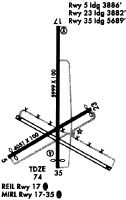
| A81-APT | REIL RWY 18 & 36; MIRL RWY 18/36, PRESET LOW INTST DUSK-DAWN; TO INCR INTST ACTVT - CTAF. |
Runways
Runway Summary
| Runways: | 06/24 18/36 |
| Longest Runway: | 18/36 is 5999 ft (1828 m) long |
| Runways with an Instrument Approach: |
OPL Airport Runway Details
| Runway 06/24 | 4051 ft x 100 ft (1235 m x 30 m) | |
| Runway Length Source: | 3RD PARTY SURVEY as of 06/01/2022 | |
| Surface: | Concrete - Fair condition - No special surface treatment | |
Runway Weight Bearing Capacity (in thousands of pounds) |
||
| Single Wheel Landing Gear: | 30.0 | |
Runway 06 |
Runway 24 |
|
Elevation: |
69.1 | 73.9 |
Latitude: |
30-33-11.0465N | 30-33-30.9993N |
Longitude: |
092-06-20.3920W | 092-05-40.1998W |
|
Runway True Alignment: |
060 | 240 |
Glide Path Angle: |
0.0 degrees | 0.0 degrees |
Traffic Pattern: |
Left | Right |
Runway Markings Type: |
Basic | Basic |
Runway Markings Condition: |
Poor | Poor |
Object at End: |
TREES | TREES |
Object Height: |
46 | 56 |
Distance from End: |
520 | 941 |
Object Centerline Offset: |
110 ft. left of centerline | 16 ft. left of centerline |
Threshold Elevation: |
69.4 | 73.9 |
Displaced Threshold: |
165 | 169 |
Threshold Latitude: |
30-33-11.8591N | 30-33-30.1687N |
Threshold Longitude: |
092-06-18.7545W | 092-05-41.8739W |
| Runway 18/36 | 5999 ft x 100 ft (1828 m x 30 m) | |
| Runway Length Source: | 3RD PARTY SURVEY as of 06/01/2022 | |
| Surface: | Concrete - Fair condition - No special surface treatment | |
| Runway Edge Lights: | Medium Intensity | |
Runway Weight Bearing Capacity (in thousands of pounds) |
||
| Single Wheel Landing Gear: | 30.0 | |
Runway 18 |
Runway 36 |
|
Elevation: |
70.5 | 70.6 |
Latitude: |
30-34-06.1492N | 30-33-06.7766N |
Longitude: |
092-05-55.9396W | 092-05-56.1351W |
|
Runway True Alignment: |
180 | 000 |
Glide Path Angle: |
3.5 degrees | 3.5 degrees |
Traffic Pattern: |
Right | Left |
Runway Markings Type: |
Nonprecision Instrument | Nonprecision Instrument |
Runway Markings Condition: |
Good | Good |
Object at End: |
TREE | ROAD |
Object Height: |
48 | 19 |
Distance from End: |
943 | 307 |
Object Centerline Offset: |
110 ft. left of centerline | 16 ft. left of centerline |
Visual Glide Slope Indicators: |
2-Light PAPI On Left Side Of Runway | 2-Light PAPI On Left Side Of Runway |
REIL: |
Yes | Yes |
Threshold Crossing Height: |
58 | 59 |
Threshold Elevation: |
70.6 | 71.9 |
Displaced Threshold: |
150 | 789 |
Threshold Latitude: |
30-34-04.6695N | 30-33-14.5840N |
Threshold Longitude: |
092-05-55.9449W | 092-05-56.1091W |
Services
Airframe Repair: |
Major |
Powerplant Repair: |
Major |
Fuel Available: |
100LL, Jet A |
Parking: |
Hangars and tiedowns available |
Maps & Diagrams
OPL Sectional
Flight Planning
at skyvector.com
at skyvector.com