Location
Latitude: |
30-02-32.7000N (30.042417) |
Longitude: |
090-01-41.7000W (-90.02825) |
Elevation: |
7.3 feet MSL (2 m MSL) |
Magnetic Variation: |
1.5 W (as of April 2024 from WMM2020 model) |
Time Zone: |
UTC -6.0 (Standard Time) UTC -5.0 (Daylight Savings Time) |
From City: |
04 N.M. NE of New Orleans, Louisiana |
Found On: |
New Orleans Chart |
FAA Region: |
ASW |
Contacts
Manager: |
Publicly owned: |
| BRUCE MARTIN 6001 STARS & STRIPES BLVD, SUITE 204 NEW ORLEANS, LA 70126 504-243-4010 |
ORLEANS LEVEE DISTRICT 6001 STARS AND STRIPES BLVD, SUITE 204 NEW ORLEANS, LA 70126 504-243-4010 |
Operations
Airport Status: |
Operational |
Facility Use: |
Public |
Type: |
Airport |
Activation Date: |
04/1940 |
Control tower: |
Yes |
Attendance (Months/Days/Hours): |
Months/Days/Hours ALL/ALL/ALL |
Boundary ARTCC: |
ZHU (Houston) |
Responsible ARTCC: |
ZHU (Houston) |
Lighting Schedule: |
SEE RMK |
Segmented Circle Indicator: |
Yes |
Traffic Pattern Altitude (MSL): |
1007 feet (307 m) |
NOTAMs Facility: |
NEW |
NOTAM-D Service: |
Yes |
International Airport of Entry: |
No |
Customs Landing Rights: |
Yes |
Military Landing Rights: |
Yes |
Civil/Military Joint Use: |
No |
Based Aircraft
| Single Engine: | 88 |
| Multi Engine: | 21 |
| Jet Engine: | 23 |
| GA Helicopters: | 8 |
Annual Operations (as of 01/01/2023)
| Total Operations: | 78170 | |
| Commercial: | 2 | 0.0% |
| Air Taxi: | 6305 | 8.1% |
| GA Local: | 28181 | 36.1% |
| GA Itinerant: | 40522 | 51.8% |
| Military Aircraft: | 3160 | 4.0% |
Communications
| CTAF: | 118.950 |
| Tower: | LAKEFRONT 118.95 Hrs: 0700-2100 |
| Clearance Del.: | 127.4 |
| Ground: | 121.7 335.575 |
| Approach: | NEW ORLEANS |
| Departure: | NEW ORLEANS |
| ATIS: | 124.9 Hrs: 24 |
| ASOS: | (504-245-4366) |
- TA35 BASIC RADAR SVC OUTSIDE OF NEW ORLEANS CLASS B BOUNDARIES AVBL.
Fixed Based Operators (FBOs) & Fuel
(Click on a business for detail)
Please help us keep this information up to date. This is a FREE SERVICE just like everything else on Airport Guide! If you see that a business needs to be added, modified, or deleted please fill out our Update Form.
To add, modify, or delete a business click here.
Please help us keep this information up to date. This is a FREE SERVICE just like everything else on Airport Guide! If you see that a business needs to be added, modified, or deleted please fill out our Update Form.
Area Code: 504 |
| Business Name | Frequency | Phone | Fuel Grade |
|---|---|---|---|
| Air Charter Associates
Website Update FBO info |
242-0455, 800-942-0455 | ||
| Air Reldan
Update FBO info |
241-9400 | ||
| Aviaport Business Jet Center
Website Update FBO info |
Unicom 122.95, Arinc 130.8 | 242-9496 | 100LL, Jet A |
| Covenant Sales and Leasing
Update FBO info |
243-9800 | ||
| Executive Air Charter
Update FBO info |
246-6543 | ||
| General Aviation Corporation
Website Update FBO info |
Unicom 122.95 | 241-2700 | 100LL, Jet A |
| KavAir
Website Update FBO info |
248-4200, 877-452-8247 | ||
| LifeFlight New Orleans
Website Update FBO info |
243-9800, 800-254-3051 | ||
| Lifeguard Air Ambulance and Executive Charter
Website Update FBO info |
241-1911, 800-262-4688 | ||
| Million Air - New Orleans
Website Update FBO info |
Unicom 122.95, Arinc 129.07 | 241-2800 | 100LL, Jet A |
| New Orleans Jet Center
Update FBO info |
242-6652 | ||
| R.F.B. Flying Service
Update FBO info |
242-8005 | ||
| Signature Flight Support
Update FBO info |
Arinc: 129.07 | +1 504 241 2800 |
Flight Service Stations
| Primary | Alternate | |
| FSS on Field: | N | |
| FSS Name (ID): | De Ridder(DRI) | |
| Frequency: | ||
| Toll Free Phone: | 1-800-WX-BRIEF |
Instrument Procedures / Charts
FAA Terminal Procedures valid from 0901Z 03/21/24 to 0901Z 04/18/24.
There are various types of charts available for an airport. They are listed in the Page Type column. Here is a legend for those types:
APD - Airport Diagram
DP - Departure Procedure Charts
HOT - Hot Spots
IAP - Instrument Approach Procedure Charts
MIN - Minimums
STAR - Standard Terminal Arrival Charts
| Page Type | Page Name | Volume | Action Since Last Cycle |
|---|---|---|---|
| APD | AIRPORT DIAGRAM | SC-4 | Changed |
| HOT | HOT SPOT | SC-4 | |
| IAP | ILS OR LOC RWY 18R | SC-4 | Changed |
| IAP | RNAV (GPS) RWY 18R | SC-4 | Changed |
| IAP | RNAV (GPS) RWY 36L | SC-4 | Changed |
| IAP | VOR/DME RWY 36L | SC-4 | Changed |
| MIN | ALTERNATE MINIMUMS | SC-4 | |
| MIN | TAKEOFF MINIMUMS | SC-4 | |
| STAR | AWDAD ONE | SC-4 | |
| STAR | MNSTR ONE (RNAV) | SC-4 | |
| STAR | OLEDD FOUR | SC-4 | |
| STAR | TRSSH ONE (RNAV) | SC-4 |
Terminal Procedures are only available for airports in several countries with more being added all the time. If you are looking for a specific country's charts, please send an email to support(at)airportguide.com stating the country name. This will be used to prioritize the implementation.
Navigation Aids (Navaids) near NEW
| Dist (NM) | ID | Morse Code | Name | Type | Freq | True Hdg | Mag Hdg |
|---|---|---|---|---|---|---|---|
| 11.6 | HRV | . . . . . _ . . . . _ | Harvey | VORTAC | 114.10 | 173 | 175 |
| 19.3 | MS | _ _ . . . | Kinte | NDB | 338 | 267 | 268 |
| 29.2 | RQR | . _ . _ _ . _ . _ . | Reserve | VOR-DME | 110.80 | 275 | 276 |
| 34.7 | PCU | . _ _ . _ . _ . . . _ | Picayune | VOR-DME | 113.95 | 26 | 28 |
| 35.0 | HMU | . . . . _ _ . . _ | Hammond | VOR | 109.60 | 324 | 325 |
| 38.5 | HS | . . . . . . . | Hanco | NDB | 221 | 50 | 52 |
| 39.5 | HP | . . . . . _ _ . | Anger | NDB | 212 | 329 | 330 |
| 47.4 | TBD | _ _ . . . _ . . | Tibby | VOR-DME | 112.00 | 241 | 242 |
| 51.1 | GVB | _ _ . . . . _ _ . . . | Bogalusa | NDB | 353 | 9 | 11 |
| 52.2 | GP | _ _ . . _ _ . | Bayou | NDB | 360 | 59 | 61 |
| 52.2 | LEV | . _ . . . . . . _ | Leeville | VORTAC | 113.50 | 184 | 185 |
| 54.0 | GPT | _ _ . . _ _ . _ | Gulfport | VORTAC | 109.00 | 65 | 67 |
| 61.0 | BIX | _ . . . . . _ . . _ | Keesler | TACAN | 111.80 | 68 | 70 |
| 69.3 | BT | _ . . . _ | Rundi | NDB | 284 | 298 | 299 |
| 70.8 | LSU | . _ . . . . . . . _ | Fighting Tiger | VORTAC | 116.50 | 292 | 293 |
| 70.9 | PTN | . _ _ . _ _ . | Patterson | NDB | 245 | 254 | 255 |
| 76.6 | MCB | _ _ _ . _ . _ . . . | Mc Comb | VORTAC | 116.70 | 351 | 352 |
| 76.9 | MC | _ _ _ . _ . | Ferni | NDB | 413 | 341 | 342 |
| 83.6 | FWX | . . _ . . _ _ _ . . _ | New Roads | NDB | 356 | 295 | 296 |
| 89.9 | LBY | . _ . . _ . . . _ . _ _ | Eaton | VORTAC | 110.60 | 23 | 25 |
Nearby Airports with Fuel
Notices to Airmen (NOTAMS)
Remarks
| A110-1 | PPR REQUIRED FOR ACFT TRNSPG ANY ITEMS LISTED IN PART 175 TITLE 49. CONTACT 504-606-9264 |
| A110-10 | TWY A UNEVEN PAVEMENT. |
| A110-11 | FOR ASSTNC AFTER 2100 LOCAL CTC AMGR 504-874-0459 |
| A110-13 | FOR FICONS AFTER HRS CALL ARFF 504-606-9264. |
| A110-14 | BOAT MASTS UP TO 80 FT WI 0.5NM OF AER RWY 27. |
| A110-15 | ARPT WINDCONE FOR BALL PARK RAMP LGTS OTS PERMLY. |
| A110-16 | CAUTION TWY F BTN TRML RAMP AND FLT LN FST RAMP IREG SFC. |
| A110-17 | FOR CD WHEN ATCT IS CLSD CTC MSY APCH AT 504-471-4350 OR 127.4 |
| A110-2 | BIRDS ON & INVOF ARPT. |
| A110-4 | BOATS AS HIGH AS 80 FT PASS WI 400 FT OF RWY 09 THLD. |
| A110-6 | ARFF CPBLTY EQUIVALENT TO INDEX B. |
| A110-7 | FUEL NOT AVAILABLE WITHIN 100' OF TERMINAL BUILDING |
| A33-18R/36L | FEW LOW SPOTS NEAR INTERSECTION OF RY 09/27-HOLDING WATER. |
| A43-36R | RWY 36R PAPI UNUSBL BTN 2100 AND 0700 LOCAL |
| A52-18R | PIER. |
| A57-18R | APCH RATIO 50:1 FM DSPLCD THR. |
| A57-36L | APCH RATIO 32:1 AT DSPLCD THR; +77' SILO 2500'; 580' R. |
| A58-36L | +7 FT WALL 150 FT FM RY END. |
| A75 | OVERNIGHT PARKING ON TERMINAL RAMP MUST BE COORDINATED WITH FBO |
| A81-APT | WHEN TWR CLSD ACTVT MALSR RWY 18R; MIRL RWY 18R/36L; TWY B, C, D, E, F, H, EAST HNGRLN - PRESET LOW INTST. ACTVT 5 CLICKS FOR MED AND 7 CLICKS FOR HIGH - CTAF. |
| A81-BCN | FOR ARPT BCN CTC ATCT. |
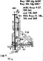
Runways
Runway Summary
| Runways: | 09/27 18L/36R 18R/36L |
| Longest Runway: | 18R/36L is 6879 ft (2097 m) long |
| Runways with an Instrument Approach: | 18R |
NEW Airport Runway Details
| Runway 09/27 | 3114 ft x 75 ft (949 m x 23 m) | |
| Runway Length Source: | 3RD PARTY SURVEY as of 10/30/2009 | |
| Surface: | Asphalt - Fair condition - No special surface treatment | |
| Runway Edge Lights: | Medium Intensity | |
Runway Weight Bearing Capacity (in thousands of pounds) |
||
| Single Wheel Landing Gear: | 50.0 | |
| Dual Wheel Landing Gear: | 80.0 | |
| Dual Tandem Wheel Landing Gear: | 100.0 | |
Runway 09 |
Runway 27 |
|
Elevation: |
4.9 | 4.7 |
Latitude: |
30-02-13.3762N | 30-02-13.8167N |
Longitude: |
090-01-50.2246W | 090-01-14.8073W |
|
Runway True Alignment: |
089 | 269 |
Glide Path Angle: |
3.0 degrees | 3.2 degrees |
Traffic Pattern: |
Left | Right |
Runway Markings Type: |
Basic | Basic |
Runway Markings Condition: |
Good | Fair |
Object at End: |
BERM | ROAD |
Object Height: |
4 | 14 |
Object Marked/Lighted?: |
Lighted | |
Distance from End: |
267 | 543 |
Object Centerline Offset: |
0 ft. left and right of centerline | 161 ft. right of centerline |
Visual Glide Slope Indicators: |
4-Light PAPI On Left Side Of Runway | 4-Light PAPI On Right Side Of Runway |
REIL: |
Yes | |
Threshold Crossing Height: |
40 | 43 |
Declared Distances |
||
Take Off Run Avbl. (TORA): |
3113 | 3113 |
Take Off Distance Avbl. (TODA): |
3113 | 3113 |
Actual Stop Dist. Avbl. (ASDA): |
3113 | 3113 |
Landing Dist. Avbl. (LDA): |
3113 | 3113 |
| Runway 18L/36R | 3697 ft x 75 ft (1127 m x 23 m) | |
| Runway Length Source: | 3RD PARTY SURVEY as of 10/30/2009 | |
| Surface: | Asphalt - Fair condition - No special surface treatment | |
| Runway Edge Lights: | Medium Intensity | |
Runway Weight Bearing Capacity (in thousands of pounds) |
||
| Single Wheel Landing Gear: | 35.0 | |
| Dual Wheel Landing Gear: | 55.0 | |
| Dual Tandem Wheel Landing Gear: | 80.0 | |
Runway 18L |
Runway 36R |
|
Elevation: |
5.2 | 6.7 |
Latitude: |
30-03-00.6658N | 30-02-24.0734N |
Longitude: |
090-01-39.6174W | 090-01-39.0584W |
|
Runway True Alignment: |
179 | 359 |
Glide Path Angle: |
0.0 degrees | 3.0 degrees |
Traffic Pattern: |
Right | |
Runway Markings Type: |
Basic | Basic |
Runway Markings Condition: |
Good | Good |
Object at End: |
BLDG | |
Object Height: |
54 | |
Object Marked/Lighted?: |
Lighted | |
Distance from End: |
2035 | |
Object Centerline Offset: |
0 ft. left and right of centerline | 161 ft. right of centerline |
Visual Glide Slope Indicators: |
4-Light PAPI On Left Side Of Runway | |
REIL: |
Yes | Yes |
Threshold Crossing Height: |
45 | |
Declared Distances |
||
Take Off Run Avbl. (TORA): |
3697 | 3697 |
Take Off Distance Avbl. (TODA): |
3697 | 3697 |
Actual Stop Dist. Avbl. (ASDA): |
3697 | 3697 |
Landing Dist. Avbl. (LDA): |
3697 | 3697 |
| Runway 18R/36L | 6879 ft x 150 ft (2097 m x 46 m) | |
| Runway Length Source: | 3RD PARTY SURVEY as of 10/30/2009 | |
| Surface: | Asphalt - Fair condition - Saw-cut or plastic grooved | |
| Runway Edge Lights: | Medium Intensity | |
Runway Weight Bearing Capacity (in thousands of pounds) |
||
| Single Wheel Landing Gear: | 60.0 | |
| Dual Wheel Landing Gear: | 175.0 | |
| Dual Tandem Wheel Landing Gear: | 200.0 | |
| Dual Dual Tandem Wheel Landing Gear: | 350.0 | |
Runway 18R |
Runway 36L |
|
Elevation: |
5.7 | 5.7 |
Latitude: |
30-03-10.1302N | 30-02-02.0444N |
Longitude: |
090-01-47.7094W | 090-01-46.7010W |
|
Runway True Alignment: |
179 | 359 |
ILS Type: |
ILS/DME | |
Glide Path Angle: |
3.0 degrees | 3.0 degrees |
Traffic Pattern: |
Right | |
Runway Markings Type: |
Precision Instrument | Nonprecision Instrument |
Runway Markings Condition: |
Good | Good |
Object at End: |
OTHER | BERM |
Object Height: |
6 | 7 |
Object Marked/Lighted?: |
Lighted | |
Distance from End: |
300 | 200 |
Object Centerline Offset: |
0 ft. left and right of centerline | 161 ft. right of centerline |
Visual Glide Slope Indicators: |
4-Light PAPI On Left Side Of Runway | 4-Light PAPI On Left Side Of Runway |
Approach Light System: |
1,400 Foot Medium Intensity Approach Lighting System With Runway Alignment Indicator Lights | |
REIL: |
Yes | |
Threshold Crossing Height: |
51 | 50 |
Threshold Elevation: |
5.8 | 6.8 |
Displaced Threshold: |
239 | 820 |
Threshold Latitude: |
30-03-07.7613N | 30-02-10.1639N |
Threshold Longitude: |
090-01-47.6702W | 090-01-46.8279W |
Declared Distances |
||
Take Off Run Avbl. (TORA): |
6880 | 6880 |
Take Off Distance Avbl. (TODA): |
6880 | 6880 |
Actual Stop Dist. Avbl. (ASDA): |
6035 | 5955 |
Landing Dist. Avbl. (LDA): |
5510 | 5135 |
Services
Airframe Repair: |
Minor |
Powerplant Repair: |
Minor |
Bottled Oxygen: |
None |
Bulk Oxygen: |
None |
Fuel Available: |
100, Jet A |
Landing Fees: |
No |
Parking: |
Hangars and tiedowns available |
Maps & Diagrams
NEW Sectional
Flight Planning
at skyvector.com
at skyvector.com