Location
Latitude: |
30-27-58.6220N (30.466284) |
Longitude: |
092-25-25.6770W (-92.423799) |
Elevation: |
42.0 feet MSL (13 m MSL) |
Magnetic Variation: |
0.1 E (as of April 2024 from WMM2020 model) |
Time Zone: |
UTC -6.0 (Standard Time) UTC -5.0 (Daylight Savings Time) |
From City: |
02 N.M. S of Eunice, Louisiana |
Found On: |
Houston Chart |
FAA Region: |
ASW |
Contacts
Manager: |
Publicly owned: |
| DREW MILLER 252 EUNICE AIRPORT ROAD EUNICE, LA 70535 337-457-6585 |
CITY OF EUNICE PO BOX 1106 EUNICE, LA 70535 337-457-7389 |
Operations
Airport Status: |
Operational |
Facility Use: |
Public |
Type: |
Airport |
Activation Date: |
09/1964 |
Control tower: |
No |
Attendance (Months/Days/Hours): |
Months/Days/Hours ALL/MON-FRI/0800-1700 |
Boundary ARTCC: |
ZHU (Houston) |
Responsible ARTCC: |
ZHU (Houston) |
Lighting Schedule: |
SEE RMK |
Segmented Circle Indicator: |
Yes |
Traffic Pattern Altitude (MSL): |
1042 feet (318 m) |
NOTAMs Facility: |
DRI |
NOTAM-D Service: |
Yes |
International Airport of Entry: |
No |
Customs Landing Rights: |
No |
Military Landing Rights: |
Yes |
Civil/Military Joint Use: |
No |
Based Aircraft
| Single Engine: | 32 |
| Multi Engine: | 1 |
Annual Operations (as of 04/09/2020)
| Total Operations: | 15000 | |
| GA Local: | 10000 | 66.7% |
| GA Itinerant: | 5000 | 33.3% |
Communications
| CTAF: | 122.800 |
| Unicom: | 122.800 |
| Approach: | LAFAYETTE 128.7 128.7 HOUSTON ARTCC |
| Departure: | LAFAYETTE 128.7 128.7 HOUSTON ARTCC |
- APCH/DEP SVC PRVDD BY HOUSTON ARTCC (ZHU) ON FREQS 126.35/338.25 (LAFAYETTE RCAG) WHEN LAFAYETTE (LFT) APCH CTL CLSD.
Fixed Based Operators (FBOs) & Fuel
(Click on a business for detail)
Please help us keep this information up to date. This is a FREE SERVICE just like everything else on Airport Guide! If you see that a business needs to be added, modified, or deleted please fill out our Update Form.
To add, modify, or delete a business click here.
Please help us keep this information up to date. This is a FREE SERVICE just like everything else on Airport Guide! If you see that a business needs to be added, modified, or deleted please fill out our Update Form.
Area Code: 318 |
| Business Name | Frequency | Phone | Fuel Grade |
|---|---|---|---|
| Eunice Flying Service
Update FBO info |
Unicom 122.8 | 457-6585 | 100LL, Jet A, MOGAS |
Flight Service Stations
| Primary | Alternate | |
| FSS on Field: | N | |
| FSS Name (ID): | De Ridder(DRI) | |
| Frequency: | ||
| Toll Free Phone: | 1-800-WX-BRIEF |
Instrument Procedures / Charts
FAA Terminal Procedures valid from 0901Z 03/21/24 to 0901Z 04/18/24.
There are various types of charts available for an airport. They are listed in the Page Type column. Here is a legend for those types:
APD - Airport Diagram
DP - Departure Procedure Charts
HOT - Hot Spots
IAP - Instrument Approach Procedure Charts
MIN - Minimums
STAR - Standard Terminal Arrival Charts
| Page Type | Page Name | Volume | Action Since Last Cycle |
|---|---|---|---|
| IAP | RNAV (GPS) RWY 16 | SC-4 | |
| IAP | RNAV (GPS) RWY 34 | SC-4 | |
| MIN | TAKEOFF MINIMUMS | SC-4 |
Terminal Procedures are only available for airports in several countries with more being added all the time. If you are looking for a specific country's charts, please send an email to support(at)airportguide.com stating the country name. This will be used to prioritize the implementation.
Navigation Aids (Navaids) near UCE
| Dist (NM) | ID | Morse Code | Name | Type | Freq | True Hdg | Mag Hdg |
|---|---|---|---|---|---|---|---|
| 5.7 | ECY | . _ . _ . _ . _ _ | Duralde | NDB | 263 | 347 | 347 |
| 17.3 | LRR | . _ . . . _ . . _ . | Oakdale | NDB | 379 | 307 | 307 |
| 20.3 | OPL | _ _ _ . _ _ . . _ . . | St Landry | NDB | 335 | 55 | 55 |
| 25.9 | BWK | _ . . . . _ _ _ . _ | Bunkie | NDB | 397 | 22 | 22 |
| 27.7 | LFT | . _ . . . . _ . _ | Lafayette | VORTAC | 109.80 | 126 | 126 |
| 28.7 | LF | . _ . . . . _ . | Laffs | NDB | 375 | 111 | 111 |
| 28.9 | BNZ | _ . . . _ . _ _ . . | Abbeville | NDB | 230 | 147 | 147 |
| 40.3 | LCH | . _ . . _ . _ . . . . . | Lake Charles | VORTAC | 113.40 | 241 | 241 |
| 41.1 | CW | _ . _ . . _ _ | Mossy | NDB | 418 | 256 | 256 |
| 41.8 | MKV | _ _ _ . _ . . . _ | Marksville | NDB | 347 | 25 | 25 |
| 42.2 | AR | . _ . _ . | Acadi | NDB | 269 | 136 | 136 |
| 47.6 | AEX | . _ . _ . . _ | Alexandria | VORTAC | 116.10 | 355 | 355 |
| 48.3 | LLA | . _ . . . _ . . . _ | White Lake | VOR-DME | 114.95 | 176 | 176 |
| 49.0 | POE | . _ _ . _ _ _ . | South | FAN MARKER | 309 | 309 | |
| 49.3 | FWX | . . _ . . _ _ _ . . _ | New Roads | NDB | 356 | 78 | 78 |
| 50.1 | DXB | _ . . _ . . _ _ . . . | De Ridder | NDB | 385 | 290 | 290 |
| 51.7 | GUV | _ _ . . . _ . . . _ | Gator | NDB | 359 | 310 | 310 |
| 54.0 | DQU | _ . . _ _ . _ . . _ | De Quincy | NDB | 410 | 268 | 268 |
| 54.1 | AUR | . _ . . _ . _ . | Sulphur | NDB | 278 | 252 | 252 |
| 56.4 | FXU | . . _ . _ . . _ . . _ | Polk | VOR | 108.40 | 313 | 313 |
Nearby Airports with Fuel
Notices to Airmen (NOTAMS)
Remarks
| A110*G | THIS AIRPORT HAS BEEN SURVEYED BY THE NATIONAL GEODETIC SURVEY. |
| A110-1 | GCO AVBL ON FREQ 135.075 THRU LAFAYETTE APCH & DRI FSS. |
| A110-2 | FOR CD CTC LAFAYETTE APCH AT 337-262-2729, WHEN APCH CLSD CTC HOUSTON ARTCC AT 281-230-5622. |
| A42-16 | RUNWAY MARKINGS SEVERELY FADED |
| A42-34 | RUNWAY MARKINGS SEVERELY FADED |
| A43-16 | RWY 16 PAPI UNUSBL BYD 6 DEGS LEFT OF CNTRLN. |
| A70-FUEL-10 | 0LL FOR FUEL AFT HRS CALL 337-457-6585. |
| A81-APT | REIL RWY 16/34 AND MIRL RWY 16/34 PRESET LOW INTST DUSK-DAWN; TO INCR INTST ACTVT - CTAF. |
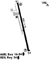
Runways
Runway Summary
| Runways: | 16/34 |
| Longest Runway: | 16/34 is 5001 ft (1524 m) long |
| Runways with an Instrument Approach: |
UCE Airport Runway Details
| Runway 16/34 | 5001 ft x 75 ft (1524 m x 23 m) | |
| Surface: | Asphalt - Good condition - No special surface treatment | |
| Runway Edge Lights: | Medium Intensity | |
Runway Weight Bearing Capacity (in thousands of pounds) |
||
| Single Wheel Landing Gear: | 21.0 | |
Runway 16 |
Runway 34 |
|
Elevation: |
39.0 | 42.0 |
Latitude: |
30-28-22.6550N | 30-27-34.6410N |
Longitude: |
092-25-32.6760W | 092-25-18.7640W |
|
Runway True Alignment: |
166 | 346 |
Glide Path Angle: |
3.0 degrees | 3.0 degrees |
Traffic Pattern: |
Left | Left |
Runway Markings Type: |
Nonprecision Instrument | Nonprecision Instrument |
Runway Markings Condition: |
Poor | Poor |
Object at End: |
TREES | TREES |
Object Height: |
67 | 48 |
Distance from End: |
1304 | 1179 |
Object Centerline Offset: |
10 ft. right of centerline | 311 ft. left of centerline |
Visual Glide Slope Indicators: |
2-Light PAPI On Left Side Of Runway | 2-Light PAPI On Left Side Of Runway |
REIL: |
Yes | Yes |
Threshold Crossing Height: |
50 | 50 |
Services
Airframe Repair: |
Major |
Powerplant Repair: |
Major |
Fuel Available: |
100LL, Jet A |
Landing Fees: |
No |
Parking: |
Tiedowns available |
Maps & Diagrams
UCE Sectional
Flight Planning
at skyvector.com
at skyvector.com