Location
Latitude: |
43-31-47.0290N (43.52973) |
Longitude: |
072-56-58.6540W (-72.949626) |
Elevation: |
787.3 feet MSL (240 m MSL) |
Magnetic Variation: |
13.6 W (as of April 2024 from WMM2020 model) |
Time Zone: |
UTC -5.0 (Standard Time) UTC -4.0 (Daylight Savings Time) |
From City: |
05 N.M. S of Rutland, Vermont |
Found On: |
New York Chart |
FAA Region: |
ANE |
Contacts
Manager: |
Publicly owned: |
| ROLLIN TEBBETTS 219 N MAIN ST BARRE, VT 05641 802-585-5586 |
STATE OF VERMONT 219 N MAIN ST BARRE, VT 05641 802-279-2647 |
Operations
Airport Status: |
Operational |
Facility Use: |
Public |
Type: |
Airport |
Activation Date: |
12/1942 |
Control tower: |
No |
Attendance (Months/Days/Hours): |
Months/Days/Hours ALL/ALL/0700-2000 |
Boundary ARTCC: |
ZBW (Boston) |
Responsible ARTCC: |
ZBW (Boston) |
Lighting Schedule: |
SEE RMK |
Segmented Circle Indicator: |
Yes |
Traffic Pattern Altitude (MSL): |
1787 feet (545 m) |
NOTAMs Facility: |
RUT |
NOTAM-D Service: |
Yes |
International Airport of Entry: |
No |
Customs Landing Rights: |
No |
Military Landing Rights: |
Yes |
Civil/Military Joint Use: |
No |
Aircraft Rescue and Firefighting: |
Class IV ARFF Index: A Air Carrier Service: Not Scheduled Certification Date: 11/2005 |
Based Aircraft
| Single Engine: | 24 |
| Multi Engine: | 5 |
| Jet Engine: | 1 |
Annual Operations (as of 05/31/2017)
| Total Operations: | 13091 | |
| Air Taxi: | 1813 | 13.8% |
| GA Local: | 6187 | 47.3% |
| GA Itinerant: | 5061 | 38.7% |
| Military Aircraft: | 30 | 0.2% |
Communications
| CTAF: | 122.800 |
| Unicom: | 122.800 |
| AWOS-3PT: | 118.375 (802-747-3044) |
- APCH/DEP SVC PRVDD BY BOSTON ARTCC ON FREQS 135.7/282.2 (MONTPELIER RCAG).
Fixed Based Operators (FBOs) & Fuel
(Click on a business for detail)
Please help us keep this information up to date. This is a FREE SERVICE just like everything else on Airport Guide! If you see that a business needs to be added, modified, or deleted please fill out our Update Form.
To add, modify, or delete a business click here.
Please help us keep this information up to date. This is a FREE SERVICE just like everything else on Airport Guide! If you see that a business needs to be added, modified, or deleted please fill out our Update Form.
Area Code: 802 |
| Business Name | Frequency | Phone | Fuel Grade |
|---|---|---|---|
| Rutland Aviation, Inc.
Update FBO info |
Unicom 122.8 | 773-3348 | 100LL, Jet A |
| S. D. Air Service
Update FBO info |
775-0205 |
Flight Service Stations
| Primary | Alternate | |
| FSS on Field: | N | |
| FSS Name (ID): | Burlington(BTV) | |
| Frequency: | ||
| Toll Free Phone: | 1-800-WX-BRIEF |
Instrument Procedures / Charts
FAA Terminal Procedures valid from 0901Z 03/21/24 to 0901Z 04/18/24.
There are various types of charts available for an airport. They are listed in the Page Type column. Here is a legend for those types:
APD - Airport Diagram
DP - Departure Procedure Charts
HOT - Hot Spots
IAP - Instrument Approach Procedure Charts
MIN - Minimums
STAR - Standard Terminal Arrival Charts
| Page Type | Page Name | Volume | Action Since Last Cycle |
|---|---|---|---|
| IAP | ILS Y OR LOC Y RWY 19 | NE-1 | |
| IAP | ILS Z OR LOC Z RWY 19 | NE-1 | |
| IAP | RNAV (GPS) RWY 01 | NE-1 | |
| IAP | RNAV (GPS) Y RWY 19 | NE-1 | |
| IAP | RNAV (GPS) Z RWY 19 | NE-1 | |
| MIN | ALTERNATE MINIMUMS | NE-1 | |
| MIN | TAKEOFF MINIMUMS | NE-1 |
Terminal Procedures are only available for airports in several countries with more being added all the time. If you are looking for a specific country's charts, please send an email to support(at)airportguide.com stating the country name. This will be used to prioritize the implementation.
Navigation Aids (Navaids) near RUT
| Dist (NM) | ID | Morse Code | Name | Type | Freq | True Hdg | Mag Hdg |
|---|---|---|---|---|---|---|---|
| 0.2 | RUT | . _ . . . _ _ | Rutland | DME | 111 | 194 | 208 |
| 6.3 | R | . _ . | Chitt | FAN MARKER | 359 | 373 | |
| 10.6 | DYO | _ . . _ . _ _ _ _ _ | Smuto | NDB | 221 | 358 | 372 |
| 21.1 | IVV | . . . . . _ . . . _ | White River | NDB | 379 | 84 | 98 |
| 22.2 | SXD | . . . _ . . _ _ . . | Springfield | NDB | 265 | 134 | 148 |
| 27.0 | CNH | _ . _ . _ . . . . . | Claremont | NDB | 233 | 110 | 124 |
| 31.0 | GFL | _ _ . . . _ . . _ . . | Glens Falls | VORTAC | 110.20 | 248 | 261 |
| 33.0 | GF | _ _ . . . _ . | Ganse | NDB | 209 | 240 | 253 |
| 33.1 | LEB | . _ . . . _ . . . | Lebanon | DME | 113.7 | 74 | 88 |
| 35.1 | LAH | . _ . . . _ . . . . | Hanover | NDB | 276 | 72 | 86 |
| 36.3 | VWD | . . . _ . _ _ _ . . | Mount Snow | NDB | 224 | 174 | 188 |
| 36.5 | CAM | _ . _ . . _ _ _ | Cambridge | VOR-DME | 115.00 | 208 | 221 |
| 39.8 | MPV | _ _ . _ _ . . . . _ | Montpelier | VOR-DME | 116.90 | 32 | 46 |
| 52.7 | EEN | . . _ . | Keene | DME | 109.4 | 146 | 160 |
| 53.0 | BTV | _ . . . _ . . . _ | Burlington | VOR-DME | 117.50 | 349 | 363 |
| 57.2 | BTV | _ . . . _ . . . _ | Burlington | VOT | 109.00 | 351 | 365 |
| 57.5 | BJA | _ . . . . _ _ _ . _ | Burlington | TACAN | 112.40 | 351 | 365 |
| 59.1 | HEU | . . . . . . . _ | Hunter | NDB | 356 | 227 | 240 |
| 60.0 | ALB | . _ . _ . . _ . . . | Albany | VORTAC | 115.30 | 218 | 231 |
| 60.8 | ALB | . _ . _ . . _ . . . | Albany | VOT | 108.20 | 219 | 232 |
Nearby Airports with Fuel
Notices to Airmen (NOTAMS)
Remarks
| A110-1 | ACFT WITH WING SPANS EXCEEDING 79 FT AUZD TO USE TWY H & TWY B EAST OF RWY 1/19 & RWY 13/31 FOR TAX & RWYS 01 & 19 FOR TKOF & LDG. NOISE SENSITIVE AREA SE OF ARPT CTC AMGR. |
| A110-10 | FOR CD CTC BOSTON ARTCC AT 603-879-6859. |
| A110-2 | RWY CONDS MAY NOT BE MNT OR RPRTD WHEN ARPT IS UNATNDD. |
| A110-3 | TYPE I & TYPE IV DEICING AVBL. |
| A110-5 | BIRDS ON & INVOF ARPT. |
| A110-6 | CLSD TO UNSKED ACR OPS WITH MORE THAN 9 PAX SEATS EXC 48 HR PPR, CALL AMGR 802-786-8881. |
| A110-7 | COLD TEMPERATURE AIRPORT. ALTITUDE CORRECTION REQUIRED AT OR BELOW -8C. |
| A110-8 | USE TWY A TO TAX TO OR FM AER 01 OR 19. |
| A110-9 | TWY C CNCTS MAIN APRON WITH TWY A. |
| A17 | FOR AFT HRS SVC CALL 802-773-3348. |
| A24 | LDG FEES MAY APPLY FOR COML ACFT. |
| A30-13/31 | NOT AVBL FOR SKEDD ACR OPS (LDG & TKOF) MORE THAN 9 PAX SEATS OR UNSKED ACR OPS AT LEAST 31 PAX SEATS. AVBL FOR ACR OPS TAXI ONLY. |
| A43-01 | OTS UFN. |
| A81-APT | ACTVT MALSR RWY 19; REIL RWY 13; MIRL RWY 01/19 & 13/31 - CTAF. |
| E111 | EXISTED PRIOR TO 1959. |
Runways
Runway Summary
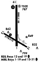
| Runways: | 01/19 13/31 |
| Longest Runway: | 01/19 is 5304 ft (1617 m) long |
| Runways with an Instrument Approach: | 19 |
RUT Airport Runway Details
| Runway 01/19 | 5304 ft x 100 ft (1617 m x 30 m) | |
| Runway Length Source: | 3RD PARTY SURVEY as of 04/17/2019 | |
| Surface: | Asphalt - Good condition - Saw-cut or plastic grooved | |
| Runway Pavement Class: | 30 /F/D/X/U | |
| Runway Edge Lights: | Medium Intensity | |
Runway Weight Bearing Capacity (in thousands of pounds) |
||
| Single Wheel Landing Gear: | 40.0 | |
| Dual Wheel Landing Gear: | 68.0 | |
Runway 01 |
Runway 19 |
|
Elevation: |
781.3 | 774.0 |
Latitude: |
43-31-26.6467N | 43-32-19.0109N |
Longitude: |
072-56-58.1094W | 072-56-59.9554W |
|
Runway True Alignment: |
359 | 179 |
ILS Type: |
ILS/DME | |
Glide Path Angle: |
3.5 degrees | 3.2 degrees |
Traffic Pattern: |
Left | Right |
Runway Markings Type: |
Nonprecision Instrument | Precision Instrument |
Runway Markings Condition: |
Good | Good |
Object at End: |
HILL | |
Object Height: |
135 | |
Distance from End: |
4800 | |
Visual Glide Slope Indicators: |
Pulsating/Steady Burning VASI On Right Side Of Runway | 4-Light PAPI On Left Side Of Runway |
Approach Light System: |
1,400 Foot Medium Intensity Approach Lighting System With Runway Alignment Indicator Lights | |
REIL: |
No | |
Threshold Crossing Height: |
17 | 55 |
Threshold Elevation: |
782.6 | |
Displaced Threshold: |
300 | |
Threshold Latitude: |
43-31-29.6053N | |
Threshold Longitude: |
072-56-58.2112W | |
Declared Distances |
||
Take Off Run Avbl. (TORA): |
5303 | 5003 |
Take Off Distance Avbl. (TODA): |
5303 | 5003 |
Actual Stop Dist. Avbl. (ASDA): |
5303 | 5003 |
Landing Dist. Avbl. (LDA): |
5003 | 5003 |
| Runway 13/31 | 3169 ft x 75 ft (966 m x 23 m) | |
| Runway Length Source: | 3RD PARTY SURVEY as of 04/17/2019 | |
| Surface: | Asphalt - Good condition - No special surface treatment | |
| Runway Pavement Class: | 5 /F/D/X/U | |
| Runway Edge Lights: | Medium Intensity | |
Runway Weight Bearing Capacity (in thousands of pounds) |
||
| Single Wheel Landing Gear: | 30.0 | |
Runway 13 |
Runway 31 |
|
Elevation: |
782.3 | 782.2 |
Latitude: |
43-31-44.8247N | 43-31-29.8200N |
Longitude: |
072-57-16.8979W | 072-56-39.1444W |
|
Runway True Alignment: |
119 | 299 |
Glide Path Angle: |
0.0 degrees | 0.0 degrees |
Traffic Pattern: |
Left | Left |
Runway Markings Type: |
Basic | Basic |
Runway Markings Condition: |
Good | Good |
Object at End: |
ROAD | TREES |
Object Height: |
16 | 20 |
Distance from End: |
325 | 600 |
REIL: |
Yes |
Services
Airframe Repair: |
None |
Powerplant Repair: |
None |
Bottled Oxygen: |
None |
Bulk Oxygen: |
None |
Landing Fees: |
No |
Parking: |
Tiedowns available |
Maps & Diagrams
RUT Sectional
Flight Planning
at skyvector.com
at skyvector.com