Location
Latitude: |
30-43-52.0000N (30.731111) |
Longitude: |
086-09-13.6000W (-86.153778) |
Elevation: |
289.1 feet MSL (88 m MSL) |
Magnetic Variation: |
4 W (as of April 2024 from WMM2020 model) |
Time Zone: |
UTC -6.0 (Standard Time) UTC -5.0 (Daylight Savings Time) |
From City: |
02 N.M. W of Defuniak Springs, Florida |
Found On: |
New Orleans Chart |
FAA Region: |
ASO |
Contacts
Manager: |
Publicly owned: |
| KOBY TOWNESEND 1931 US HIGHWAY 90 W DE FUNIAK SPRINGS, FL 32435 (850) 892-2000 |
CITY OF DE FUNIAK SPRINGS P.O. BOX 685 DEFUNIAK SPRINGS, FL 32435-0685 850-892-8500 |
Operations
Airport Status: |
Operational |
Facility Use: |
Public |
Type: |
Airport |
Activation Date: |
04/1946 |
Control tower: |
No |
Attendance (Months/Days/Hours): |
Months/Days/Hours ALL/MON-FRI/0800-1700 |
Boundary ARTCC: |
ZJX (Jacksonville) |
Responsible ARTCC: |
ZJX (Jacksonville) |
Lighting Schedule: |
SEE RMK |
Segmented Circle Indicator: |
Yes |
Traffic Pattern Altitude (MSL): |
1289 feet (393 m) |
NOTAMs Facility: |
GNV |
NOTAM-D Service: |
Yes |
International Airport of Entry: |
No |
Customs Landing Rights: |
No |
Military Landing Rights: |
Yes |
Civil/Military Joint Use: |
No |
Based Aircraft
| Single Engine: | 31 |
| Multi Engine: | 1 |
| GA Helicopters: | 2 |
Annual Operations (as of 02/15/2019)
| Total Operations: | 17800 | |
| Air Taxi: | 200 | 1.1% |
| GA Local: | 10600 | 59.6% |
| GA Itinerant: | 5500 | 30.9% |
| Military Aircraft: | 1500 | 8.4% |
Communications
| CTAF: | 123.050 |
| Unicom: | 123.050 |
| Approach: | EGLIN 124.05 124.05 |
| Departure: | EGLIN 124.05 124.05 |
| AWOS-3P: | 118.725 (850-892-0147) |
- IFR CLEARANCE CTC EGLIN RAPCON 850-882-9151 PRIOR TO DEPARTURE.
Fixed Based Operators (FBOs) & Fuel
(Click on a business for detail)
Please help us keep this information up to date. This is a FREE SERVICE just like everything else on Airport Guide! If you see that a business needs to be added, modified, or deleted please fill out our Update Form.
To add, modify, or delete a business click here.
Please help us keep this information up to date. This is a FREE SERVICE just like everything else on Airport Guide! If you see that a business needs to be added, modified, or deleted please fill out our Update Form.
Area Code: 850 |
| Business Name | Frequency | Phone | Fuel Grade |
|---|---|---|---|
| De Funiak Springs Airport
Update FBO info |
892-2000 | 100LL |
Flight Service Stations
| Primary | Alternate | |
| FSS on Field: | N | |
| FSS Name (ID): | Gainesville(GNV) | |
| Frequency: | ||
| Toll Free Phone: | 1-800-WX-BRIEF |
Instrument Procedures / Charts
FAA Terminal Procedures valid from 0901Z 03/21/24 to 0901Z 04/18/24.
There are various types of charts available for an airport. They are listed in the Page Type column. Here is a legend for those types:
APD - Airport Diagram
DP - Departure Procedure Charts
HOT - Hot Spots
IAP - Instrument Approach Procedure Charts
MIN - Minimums
STAR - Standard Terminal Arrival Charts
| Page Type | Page Name | Volume | Action Since Last Cycle |
|---|---|---|---|
| IAP | RNAV (GPS) RWY 09 | SE-3 | |
| IAP | RNAV (GPS) RWY 27 | SE-3 | |
| MIN | ALTERNATE MINIMUMS | SE-3 | |
| MIN | TAKEOFF MINIMUMS | SE-3 |
Terminal Procedures are only available for airports in several countries with more being added all the time. If you are looking for a specific country's charts, please send an email to support(at)airportguide.com stating the country name. This will be used to prioritize the implementation.
Navigation Aids (Navaids) near 54J
| Dist (NM) | ID | Morse Code | Name | Type | Freq | True Hdg | Mag Hdg |
|---|---|---|---|---|---|---|---|
| 21.0 | CE | _ . _ . . | Kobra | NDB | 201 | 290 | 294 |
| 24.3 | DWG | _ . . . _ _ _ _ . | Warrington | TACAN | 134.50 | 231 | 235 |
| 27.7 | CEW | _ . _ . . . _ _ | Crestview | VORTAC | 115.90 | 282 | 286 |
| 29.4 | BKK | _ . . . _ . _ _ . _ | Tri County | NDB | 275 | 75 | 79 |
| 30.9 | PFN | . _ _ . . . _ . _ . | Lynne | NDB | 278 | 141 | 145 |
| 33.1 | HRT | . . . . . _ . _ | Hurlburt | TACAN | 110.80 | 236 | 240 |
| 34.4 | OZ | _ _ _ _ _ . . | Brynt | NDB | 212 | 30 | 34 |
| 36.3 | EDN | . _ . . _ . | Enterprise | VOR | 116.60 | 20 | 24 |
| 36.5 | JUY | . _ _ _ . . _ _ . _ _ | Judd | NDB | 264 | 340 | 344 |
| 37.6 | BVG | _ . . . . . . _ _ _ . | Boll Weevil | NDB | 352 | 13 | 17 |
| 39.0 | OZR | _ _ _ _ _ . . . _ . | Cairns | VOR-DME | 111.20 | 34 | 38 |
| 41.0 | NGS | _ . _ _ . . . . | Santa Rosa | TACAN | 133.60 | 260 | 264 |
| 43.3 | LOR | . _ . . _ _ _ . _ . | Lowe | NDB | 269 | 29 | 33 |
| 44.6 | NSE | _ . . . . . | Whiting | TACAN | 112.30 | 269 | 273 |
| 46.4 | HEY | . . . . . _ . _ _ | Hanchey | VOR | 110.60 | 33 | 37 |
| 46.5 | HYE | . . . . _ . _ _ . | Hanchey | NDB | 221 | 33 | 37 |
| 48.6 | SMY | . . . _ _ _ . _ _ | Soyya | NDB | 329 | 79 | 83 |
| 49.6 | PAM | . _ _ . . _ _ _ | Tyndall | TACAN | 133.70 | 142 | 146 |
| 49.8 | RRS | . _ . . _ . . . . | Wiregrass | VORTAC | 111.60 | 48 | 52 |
| 53.2 | MAI | _ _ . _ . . | Marianna | VORTAC | 114.00 | 86 | 90 |
Nearby Airports with Fuel
Notices to Airmen (NOTAMS)
Remarks
| A11 | SARA BOWERS |
| A110-3 | TREES OBST LN OF SIGHT BTN RWY 09 & 36 AND RWY 27 & 36. RWY 09 & 27 LN OF SIGHT OBST DUE TO RWY 09 UP SLOPE. |
| A110-4 | RWY SAFETY AREA E OF RWY 18/36. |
| A30A-09 | UNLGTD FENCE & RD 160 FT S OF CNTRLN PENETRATES APCH SFC. |
| A42-18 | WHITE PVC PIPE EVERY 200 FT. |
| A42-36 | WHITE PVC PIPE EVERY 200 FT. |
| A57-27 | APCH SLOPE 28:1 TO DSPLCD THR; 50 FT TREES 250 L OF CNTRLN 770 FT FM RWY END. |
| A58-09 | FENCE 6FT TALL, 200 FT BFR AER, 160 FT RIGHT OF CNTRLN. |
| A70-FUEL-10 | 0LL FUEL 24 HR CREDIT CARD SVC AVBL. |
| A81-APT | ACTVT PAPI RWY 9 & 27; MIRL RWY 09/27 - CTAF. |
| E111 | VFR ONLY. |
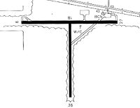
Runways
Runway Summary
| Runways: | 09/27 18/36 |
| Longest Runway: | 09/27 is 4146 ft (1264 m) long |
| Runways with an Instrument Approach: |
54J Airport Runway Details
| Runway 09/27 | 4146 ft x 60 ft (1264 m x 18 m) | |
| Runway Length Source: | 3RD PARTY SURVEY as of 05/21/2007 | |
| Surface: | Asphalt - Fair condition - No special surface treatment | |
| Runway Pavement Class: | 6 /F/A/X/T | |
| Runway Edge Lights: | Medium Intensity | |
Runway Weight Bearing Capacity (in thousands of pounds) |
||
| Single Wheel Landing Gear: | 20.0 | |
Runway 09 |
Runway 27 |
|
Elevation: |
283.6 | 278.0 |
Latitude: |
30-43-57.5443N | 30-43-57.2677N |
Longitude: |
086-09-38.7292W | 086-08-51.2223W |
|
Runway True Alignment: |
090 | 270 |
Glide Path Angle: |
3.0 degrees | 3.0 degrees |
Traffic Pattern: |
Left | Left |
Runway Markings Type: |
Nonprecision Instrument | Nonprecision Instrument |
Runway Markings Condition: |
Good | Good |
Object at End: |
FENCE | RR |
Object Height: |
6 | 28 |
Distance from End: |
200 | 475 |
Object Centerline Offset: |
165 ft. right of centerline | 250 ft. right of centerline |
Visual Glide Slope Indicators: |
2-Light PAPI On Left Side Of Runway | 2-Light PAPI On Left Side Of Runway |
Threshold Crossing Height: |
43 | 49 |
Threshold Elevation: |
277.6 | |
Displaced Threshold: |
605 | |
Threshold Latitude: |
30-43-57.3100N | |
Threshold Longitude: |
086-08-58.1500W |
| Runway 18/36 | 2700 ft x 60 ft (823 m x 18 m) | |
| Runway Length Source: | 3RD PARTY SURVEY as of 05/21/2007 | |
| Surface: | Asphalt - Fair condition - No special surface treatment | |
Runway 18 |
Runway 36 |
|
Elevation: |
282.1 | 268.7 |
Latitude: |
30-43-57.1206N | 30-43-30.3969N |
Longitude: |
086-09-11.3899W | 086-09-11.6762W |
|
Runway True Alignment: |
181 | 001 |
Glide Path Angle: |
0.0 degrees | 0.0 degrees |
Runway Markings Type: |
Nonstandard (other than numbers only) | Nonstandard (other than numbers only) |
Runway Markings Condition: |
Fair | Fair |
Object at End: |
PLINE | TREES |
Object Height: |
34 | 26 |
Distance from End: |
933 | 1280 |
Object Centerline Offset: |
165 ft. right of centerline | 250 ft. right of centerline |
Threshold Elevation: |
282.1 | 270.4 |
Displaced Threshold: |
165 | 400 |
Threshold Latitude: |
30-43-55.4877N | 30-43-34.3562N |
Threshold Longitude: |
086-09-11.4073W | 086-09-11.6335W |
Services
Airframe Repair: |
Major |
Powerplant Repair: |
Major |
Bottled Oxygen: |
None |
Bulk Oxygen: |
None |
Fuel Available: |
100LL |
Landing Fees: |
No |
Parking: |
Tiedowns available |
Maps & Diagrams
54J Sectional
Flight Planning
at skyvector.com
at skyvector.com