Location
Latitude: |
30-23-53.7950N (30.398276) |
Longitude: |
087-20-56.4150W (-87.349004) |
Elevation: |
32.0 feet MSL (10 m MSL) |
Magnetic Variation: |
3.2 W (as of April 2024 from WMM2020 model) |
Time Zone: |
UTC -6.0 (Standard Time) UTC -5.0 (Daylight Savings Time) |
From City: |
07 N.M. SW of Pensacola, Florida |
Found On: |
New Orleans Chart |
FAA Region: |
ASO |
Contacts
Manager: |
Privately owned: |
| KENNY BROWN 9750 AILERON AVE PENSACOLA, FL 32506 (850) 453-4181 |
BROWN HELICOPTER INC. 10100 AILERON AVENUE PENSACOLA, FL 32506 850-455-0971 |
Operations
Airport Status: |
Operational |
Facility Use: |
Public |
Type: |
Airport |
Control tower: |
No |
Attendance (Months/Days/Hours): |
Months/Days/Hours ALL/MON-FRI/0900-1700 |
Boundary ARTCC: |
ZJX (Jacksonville) |
Responsible ARTCC: |
ZJX (Jacksonville) |
Lighting Schedule: |
SEE RMK |
Segmented Circle Indicator: |
No |
Traffic Pattern Altitude (MSL): |
1032 feet (315 m) |
NOTAMs Facility: |
GNV |
NOTAM-D Service: |
Yes |
International Airport of Entry: |
No |
Customs Landing Rights: |
No |
Military Landing Rights: |
No |
Civil/Military Joint Use: |
No |
Based Aircraft
| Single Engine: | 30 |
| Multi Engine: | 1 |
| GA Helicopters: | 2 |
Annual Operations (as of 03/06/2018)
| Total Operations: | 67500 | |
| GA Local: | 50000 | 74.1% |
| GA Itinerant: | 17500 | 25.9% |
Communications
| CTAF: | 122.800 |
| Unicom: | 122.800 |
Fixed Based Operators (FBOs) & Fuel
(Click on a business for detail)
Please help us keep this information up to date. This is a FREE SERVICE just like everything else on Airport Guide! If you see that a business needs to be added, modified, or deleted please fill out our Update Form.
To add, modify, or delete a business click here.
Please help us keep this information up to date. This is a FREE SERVICE just like everything else on Airport Guide! If you see that a business needs to be added, modified, or deleted please fill out our Update Form.
Area Code: 850 |
| Business Name | Frequency | Phone | Fuel Grade |
|---|---|---|---|
| Ferguson Flying Service, Inc.
Update FBO info |
Unicom 122.8 | 453-4301 | 100LL |
Flight Service Stations
| Primary | Alternate | |
| FSS on Field: | N | |
| FSS Name (ID): | Gainesville(GNV) | |
| Frequency: | ||
| Toll Free Phone: | 1-800-WX-BRIEF |
Instrument Procedures / Charts
Terminal Procedures are only available for airports in several countries with more being added all the time. If you are looking for a specific country's charts, please send an email to support(at)airportguide.com stating the country name. This will be used to prioritize the implementation.
Navigation Aids (Navaids) near 82J
| Dist (NM) | ID | Morse Code | Name | Type | Freq | True Hdg | Mag Hdg |
|---|---|---|---|---|---|---|---|
| 2.9 | NPA | _ . . _ _ . . _ | Pensacola | TACAN | 117.20 | 145 | 148 |
| 4.5 | NUN | _ . . . _ _ . | Saufley | VOR | 112.25 | 8 | 11 |
| 9.1 | PKZ | . _ _ . _ . _ _ _ . . | Pickens | NDB | 326 | 75 | 78 |
| 20.4 | ESU | . . . . . . _ | Summerdale | NDB | 204 | 287 | 290 |
| 24.9 | NGS | _ . _ _ . . . . | Santa Rosa | TACAN | 133.60 | 58 | 61 |
| 26.0 | NSE | _ . . . . . | Whiting | TACAN | 112.30 | 41 | 44 |
| 34.1 | HRT | . . . . . _ . _ | Hurlburt | TACAN | 110.80 | 86 | 89 |
| 38.7 | BFM | _ . . . . . _ . _ _ | Brookley | VORTAC | 116.35 | 289 | 292 |
| 43.1 | CEW | _ . _ . . . _ _ | Crestview | VORTAC | 115.90 | 53 | 56 |
| 43.1 | DWG | _ . . . _ _ _ _ . | Warrington | TACAN | 134.50 | 83 | 87 |
| 50.0 | CE | _ . _ . . | Kobra | NDB | 201 | 56 | 60 |
| 53.9 | MOB | _ _ _ _ _ _ . . . | Wisle | NDB | 248 | 294 | 297 |
| 55.8 | SJI | . . . . _ _ _ . . | Semmes | VORTAC | 115.30 | 290 | 293 |
| 63.7 | MVC | _ _ . . . _ _ . _ . | Monroeville | VORTAC | 116.80 | 359 | 362 |
| 72.1 | GCV | _ _ . _ . _ . . . . _ | Greene County | VORTAC | 115.70 | 305 | 308 |
| 73.5 | JUY | . _ _ _ . . _ _ . _ _ | Judd | NDB | 264 | 41 | 45 |
| 81.2 | PFN | . _ _ . . . _ . _ . | Lynne | NDB | 278 | 92 | 96 |
| 81.8 | BIX | _ . . . . . _ . . _ | Keesler | TACAN | 111.80 | 270 | 273 |
| 89.4 | GPT | _ _ . . _ _ . _ | Gulfport | VORTAC | 109.00 | 270 | 273 |
| 90.3 | BVG | _ . . . . . . _ _ _ . | Boll Weevil | NDB | 352 | 50 | 54 |
Nearby Airports with Fuel
Notices to Airmen (NOTAMS)
Remarks
| A11 | THOMAS BROWN |
| A110-1 | APCH AND DEP NORTH OF THE ARPT |
| A110-2 | ARPT LIES WITHIN 3 NM OF NAS PENSACOLA SHERMAN FIELD (NPA). |
| A110-3 | FREQUENT FLIGHT DEMONSTRATIONS AND PRACTICE AIRSHOWS AT NPA. |
| A110-5 | FOR CD CTC PENSACOLA APCH AT 850-266-6884 OR 850-266-6885. |
| A17 | AFT HRS CALL 850 453 4181 |
| A33-18/36 | 80 FT WRN PTN OF RWY IS TURF, 40 FT CNTR PTN OF RWY IS ASPH, 20 FT ERN PTN IS TURF. |
| A40-18/36 | RWY LGTS 200 FT SPACING USING LEDS. RWY 18/36 MKD WITH PAVERS & LGTS. |
| A57-18 | APCH RATIO 20:1 TO DSPLCD THLD. |
| A70-FUEL-10 | 0LL 24 HR FUEL AVBL. |
| A81-APT | ACTVT LIRL RWY 18/36 - CTAF. |
| E111 | EXISTED PRIOR TO 1959. |
Runways
Runway Summary
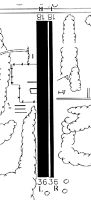
| Runways: | 18/36 |
| Longest Runway: | 18/36 is 3225 ft (983 m) long |
| Runways with an Instrument Approach: |
82J Airport Runway Details
| Runway 18/36 | 3225 ft x 140 ft (983 m x 43 m) | |
| Runway Length Source: | STATE as of 12/20/2018 | |
| Surface: | Asphalt/Turf - Fair condition - No special surface treatment | |
| Runway Edge Lights: | Non-standard lighting system Intensity | |
Runway 18 |
Runway 36 |
|
Elevation: |
28.0 | 32.0 |
Latitude: |
30-24-09.6900N | 30-23-37.9000N |
Longitude: |
087-20-54.8300W | 087-20-58.0000W |
Glide Path Angle: |
0.0 degrees | 0.0 degrees |
Runway Markings Type: |
Nonstandard (other than numbers only) | Nonstandard (other than numbers only) |
Runway Markings Condition: |
Good | Good |
Object at End: |
TREE | TREE |
Object Height: |
36 | 16 |
Distance from End: |
357 | 314 |
Object Centerline Offset: |
75 ft. left of centerline | 10 ft. left of centerline |
Threshold Elevation: |
29.0 | |
Displaced Threshold: |
280 | |
Threshold Latitude: |
30-24-06.9300N | |
Threshold Longitude: |
087-20-55.1300W |
Services
Airframe Repair: |
None |
Powerplant Repair: |
None |
Bottled Oxygen: |
None |
Bulk Oxygen: |
None |
Fuel Available: |
100LL |
Landing Fees: |
No |
Parking: |
Tiedowns available |
Maps & Diagrams
82J Sectional
Flight Planning
at skyvector.com
at skyvector.com