Location
Latitude: |
30-50-17.5970N (30.838221) |
Longitude: |
085-10-56.0050W (-85.182224) |
Elevation: |
110.7 feet MSL (34 m MSL) |
Magnetic Variation: |
4.7 W (as of April 2024 from WMM2020 model) |
Time Zone: |
UTC -6.0 (Standard Time) UTC -5.0 (Daylight Savings Time) |
From City: |
04 N.M. NE of Marianna, Florida |
Found On: |
New Orleans Chart |
FAA Region: |
ASO |
Contacts
Manager: |
Publicly owned: |
| DOUG GLASS MARIANNA MUNICIPAL AIRPORT, 3689 INDUSTRIAL PARK DR MARIANNA, FL 32446 850-482-2281 |
MARIANNA MUNI AIRPORT AUTHORITY P.O. BOX 936 MARIANNA, FL 32447 850-482- |
Operations
Airport Status: |
Operational |
Facility Use: |
Public |
Type: |
Airport |
Activation Date: |
09/1943 |
Control tower: |
No |
Attendance (Months/Days/Hours): |
Months/Days/Hours ALL/MON-FRI/0800-1700 |
Boundary ARTCC: |
ZJX (Jacksonville) |
Responsible ARTCC: |
ZJX (Jacksonville) |
Lighting Schedule: |
SEE RMK |
Segmented Circle Indicator: |
Yes |
Traffic Pattern Altitude (MSL): |
1111 feet (339 m) |
NOTAMs Facility: |
MAI |
NOTAM-D Service: |
Yes |
International Airport of Entry: |
No |
Customs Landing Rights: |
No |
Military Landing Rights: |
Yes |
Civil/Military Joint Use: |
No |
Based Aircraft
| Single Engine: | 36 |
| Multi Engine: | 1 |
| GA Helicopters: | 4 |
Annual Operations (as of 03/09/2018)
| Total Operations: | 28016 | |
| GA Local: | 10816 | 38.6% |
| GA Itinerant: | 8000 | 28.6% |
| Military Aircraft: | 9200 | 32.8% |
Communications
| CTAF: | 123.000 |
| Unicom: | 123.000 |
| Approach: | CAIRNS 133.75 133.75 JAX ARTCC |
| Departure: | CAIRNS 133.75 133.75 JAX ARTCC |
| ASOS: | 133.525 (850-482-6082) |
- APCH/DEP SVC PRVDD BY JACKSONVILLE ARTCC ON FREQS 134.3/322.55 (DOTHAN RCAG) WHEN CAIRNS APCH/DEP CLSD.
Fixed Based Operators (FBOs) & Fuel
(Click on a business for detail)
Please help us keep this information up to date. This is a FREE SERVICE just like everything else on Airport Guide! If you see that a business needs to be added, modified, or deleted please fill out our Update Form.
To add, modify, or delete a business click here.
Please help us keep this information up to date. This is a FREE SERVICE just like everything else on Airport Guide! If you see that a business needs to be added, modified, or deleted please fill out our Update Form.
Area Code: 850 |
| Business Name | Frequency | Phone | Fuel Grade |
|---|---|---|---|
| Chipola Aviation
Update FBO info |
Unicom 123.0 | 482-8480 | |
| Marianna Municipal Airport
Update FBO info |
Unicom 123.0 | 482-2281, -4761, after hours call 482-3517 or 579-2517 | 100LL, Jet A |
| SkyWarrior Flight Support Inc
Update FBO info |
CTAF- 123.00 Unicom- 123.00 | 850-898-1328 | 100LL, Jet A |

|
100LL - 4.53 USD per gallon on 10/2/15 |
Trucks |
|
|
|
Jet A - 4.26 USD per gallon on 10/2/15 |
Trucks |
Flight Service Stations
| Primary | Alternate | |
| FSS on Field: | N | |
| FSS Name (ID): | Gainesville(GNV) | |
| Frequency: | ||
| Toll Free Phone: | 1-800-WX-BRIEF |
Instrument Procedures / Charts
FAA Terminal Procedures valid from 0901Z 03/21/24 to 0901Z 04/18/24.
There are various types of charts available for an airport. They are listed in the Page Type column. Here is a legend for those types:
APD - Airport Diagram
DP - Departure Procedure Charts
HOT - Hot Spots
IAP - Instrument Approach Procedure Charts
MIN - Minimums
STAR - Standard Terminal Arrival Charts
| Page Type | Page Name | Volume | Action Since Last Cycle |
|---|---|---|---|
| IAP | RNAV (GPS) RWY 18 | SE-3 | |
| IAP | VOR-A | SE-3 | |
| MIN | ALTERNATE MINIMUMS | SE-3 | |
| MIN | TAKEOFF MINIMUMS | SE-3 |
Terminal Procedures are only available for airports in several countries with more being added all the time. If you are looking for a specific country's charts, please send an email to support(at)airportguide.com stating the country name. This will be used to prioritize the implementation.
Navigation Aids (Navaids) near KMAI
| Dist (NM) | ID | Morse Code | Name | Type | Freq | True Hdg | Mag Hdg |
|---|---|---|---|---|---|---|---|
| 3.0 | SMY | . . . _ _ _ . _ _ | Soyya | NDB | 329 | 312 | 317 |
| 4.3 | MAI | _ _ . _ . . | Marianna | VORTAC | 114.00 | 136 | 141 |
| 21.6 | BKK | _ . . . _ . _ _ . _ | Tri County | NDB | 275 | 272 | 277 |
| 29.7 | RRS | . _ . . _ . . . . | Wiregrass | VORTAC | 111.60 | 334 | 339 |
| 34.8 | LYZ | . _ . . _ . _ _ _ _ . . | Willis | NDB | 359 | 76 | 81 |
| 38.1 | OZR | _ _ _ _ _ . . . _ . | Cairns | VOR-DME | 111.20 | 312 | 317 |
| 40.0 | OZ | _ _ _ _ _ . . | Brynt | NDB | 212 | 305 | 310 |
| 40.2 | HEY | . . . . . _ . _ _ | Hanchey | VOR | 110.60 | 323 | 328 |
| 40.4 | HYE | . . . . _ . _ _ . | Hanchey | NDB | 221 | 323 | 328 |
| 41.5 | IWJ | . . . _ _ . _ _ _ | Blaak | NDB | 344 | 26 | 31 |
| 42.6 | LOR | . _ . . _ _ _ . _ . | Lowe | NDB | 269 | 317 | 322 |
| 43.6 | PFN | . _ _ . . . _ . _ . | Lynne | NDB | 278 | 225 | 229 |
| 45.0 | SZW | . . . _ _ . . . _ _ | Seminole | VORTAC | 117.50 | 111 | 116 |
| 46.1 | EDN | . _ . . _ . | Enterprise | VOR | 116.60 | 306 | 311 |
| 50.1 | PAM | . _ _ . . _ _ _ | Tyndall | TACAN | 133.70 | 203 | 208 |
| 50.5 | TLH | _ . _ . . . . . . | Tallahassee Muni | VOT | 111.00 | 122 | 127 |
| 50.9 | BVG | _ . . . . . . _ _ _ . | Boll Weevil | NDB | 352 | 306 | 310 |
| 52.5 | TL | _ . _ . . | Wakul | NDB | 379 | 125 | 130 |
| 52.8 | CYR | _ . _ . _ . _ _ . _ . | Caidy | NDB | 338 | 86 | 91 |
| 53.6 | CXU | _ . _ . _ . . _ . . _ | Camilla | NDB | 369 | 64 | 69 |
Nearby Airports with Fuel
Notices to Airmen (NOTAMS)
Remarks
| A11 | CONTACT PERSON: WILLIAM LONG, CITY MANAGER 850-482-4353. |
| A110-1 | MIL HEL OPS ON & INVOF ARPT. |
| A110-2 | FOR CD CTC CAIRNS APCH AT 334-255-8402, WHEN APCH CLSD CTC JACKSONVILLE ARTCC AT 904-845-1592. |
| A17 | EXCLUDING HOLIDAYS. |
| A33-08/26 | RWY 08/26 CRACKING WITH GRASS GROWING & PRODUCING LOOSE AGGREGATE. |
| A42-08 | FADED. |
| A42-26 | FADED. |
| A81-APT | ACTVT PAPI RWY 18 & 36; MIRL RWY 18/36 - CTAF. |
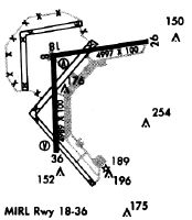
Runways
Runway Summary
| Runways: | 08/26 18/36 |
| Longest Runway: | 18/36 is 6001 ft (1829 m) long |
| Runways with an Instrument Approach: |
KMAI Airport Runway Details
| Runway 08/26 | 4763 ft x 100 ft (1452 m x 30 m) | |
| Runway Length Source: | 3RD PARTY SURVEY as of 02/25/2020 | |
| Surface: | Asphalt - Poor condition - No special surface treatment | |
| Runway Pavement Class: | 24 /F/A/W/T | |
Runway 08 |
Runway 26 |
|
Elevation: |
110.0 | 108.9 |
Latitude: |
30-50-26.4022N | 30-50-32.9883N |
Longitude: |
085-11-07.4570W | 085-10-13.3616W |
|
Runway True Alignment: |
082 | 262 |
Glide Path Angle: |
0.0 degrees | 0.0 degrees |
Traffic Pattern: |
Left | Left |
Runway Markings Type: |
Nonprecision Instrument | Nonprecision Instrument |
Runway Markings Condition: |
Poor | Poor |
Object at End: |
TREES | PLINE |
Object Height: |
40 | 35 |
Distance from End: |
1785 | 1440 |
Object Centerline Offset: |
50 ft. left of centerline | 0 ft. left and right of centerline |
| Runway 18/36 | 6001 ft x 100 ft (1829 m x 30 m) | |
| Runway Length Source: | 3RD PARTY SURVEY as of 02/25/2020 | |
| Surface: | Asphalt - Poor condition - No special surface treatment | |
| Runway Pavement Class: | 52 /F/A/W/T | |
| Runway Edge Lights: | Medium Intensity | |
Runway 18 |
Runway 36 |
|
Elevation: |
110.5 | 104.6 |
Latitude: |
30-50-37.6900N | 30-49-38.2980N |
Longitude: |
085-11-08.3895W | 085-11-08.3752W |
|
Runway True Alignment: |
180 | 360 |
Glide Path Angle: |
2.8 degrees | 3.0 degrees |
Traffic Pattern: |
Left | Left |
Runway Markings Type: |
Precision Instrument | Nonprecision Instrument |
Runway Markings Condition: |
Good | Good |
Object at End: |
TREE | TREES |
Object Height: |
39 | 53 |
Distance from End: |
1580 | 1892 |
Object Centerline Offset: |
50 ft. left of centerline | 0 ft. left and right of centerline |
Visual Glide Slope Indicators: |
4-Light PAPI On Left Side Of Runway | 4-Light PAPI On Left Side Of Runway |
Threshold Crossing Height: |
40 | 42 |
Services
Airframe Repair: |
Major |
Powerplant Repair: |
Major |
Bottled Oxygen: |
None |
Bulk Oxygen: |
None |
Fuel Available: |
100LL, Jet A, Jet A+ |
Landing Fees: |
No |
Parking: |
Hangars and tiedowns available |
Maps & Diagrams
KMAI Sectional
Flight Planning
at skyvector.com
at skyvector.com