Location
Latitude: |
45-34-57.4120N (45.582614) |
Longitude: |
123-03-10.3860W (-123.052885) |
Elevation: |
174.0 feet MSL (53 m MSL) |
Magnetic Variation: |
14.9 E (as of April 2024 from WMM2020 model) |
Time Zone: |
UTC -8.0 (Standard Time) UTC -7.0 (Daylight Savings Time) |
From City: |
03 N.M. N of Cornelius, Oregon |
Found On: |
Seattle Chart |
FAA Region: |
ANM |
Contacts
Manager: |
Privately owned: |
| GUY PUTMAN 36525 SALZWEDEL RD CORNELIUS, OR 97113 503-648-9311 |
V D PUTMAN 36525 SALZWEDEL RD CORNELIUS, OR 97113 503-648-9311 |
Operations
Airport Status: |
Operational |
Facility Use: |
Public |
Type: |
Airport |
Control tower: |
No |
Attendance (Months/Days/Hours): |
Months/Days/Hours ALL/ALL/0600-2000 |
Boundary ARTCC: |
ZSE (Seattle) |
Responsible ARTCC: |
ZSE (Seattle) |
Segmented Circle Indicator: |
Yes |
Traffic Pattern Altitude (MSL): |
1174 feet (358 m) |
NOTAMs Facility: |
MMV |
NOTAM-D Service: |
Yes |
Military Landing Rights: |
No |
Civil/Military Joint Use: |
No |
Based Aircraft
| Single Engine: | 3 |
Annual Operations (as of 01/08/2019)
| Total Operations: | 2000 | |
| GA Local: | 750 | 37.5% |
| GA Itinerant: | 1250 | 62.5% |
Communications
| CTAF: | 122.900 |
Fixed Based Operators (FBOs) & Fuel
(Click on a business for detail)
Please help us keep this information up to date. This is a FREE SERVICE just like everything else on Airport Guide! If you see that a business needs to be added, modified, or deleted please fill out our Update Form.
To add, modify, or delete a business click here.
Please help us keep this information up to date. This is a FREE SERVICE just like everything else on Airport Guide! If you see that a business needs to be added, modified, or deleted please fill out our Update Form.
Area Code: 503 |
| Business Name | Frequency | Phone | Fuel Grade |
|---|---|---|---|
| Putman Flying
Update FBO info |
648-9311 | 100LL |
Flight Service Stations
| Primary | Alternate | |
| FSS on Field: | N | |
| FSS Name (ID): | Mc Minnville(MMV) | |
| Frequency: | ||
| Toll Free Phone: | 1-800-WX-BRIEF |
Instrument Procedures / Charts
Terminal Procedures are only available for airports in several countries with more being added all the time. If you are looking for a specific country's charts, please send an email to support(at)airportguide.com stating the country name. This will be used to prioritize the implementation.
Navigation Aids (Navaids) near 4S4
| Dist (NM) | ID | Morse Code | Name | Type | Freq | True Hdg | Mag Hdg |
|---|---|---|---|---|---|---|---|
| 2.9 | PND | . _ _ . _ . _ . . | Banks | NDB | 356 | 5 | 350 |
| 5.1 | HIO | . . . . . . _ _ _ | Hillsboro | VOT | 115.20 | 119 | 104 |
| 14.1 | UBG | . . _ _ . . . _ _ . | Newberg | VOR-DME | 117.40 | 167 | 152 |
| 18.5 | CBU | _ . _ . _ . . . . . _ | Columbia | TACAN | 109.20 | 88 | 73 |
| 18.8 | PDX | . _ _ . _ . . _ . . _ | Portland | VOR-DME | 111.80 | 87 | 72 |
| 18.9 | PDX | . _ _ . _ . . _ . . _ | Portland | VOT | 111.00 | 87 | 72 |
| 21.7 | BTG | _ . . . _ _ _ . | Battle Ground | VORTAC | 116.60 | 62 | 47 |
| 24.9 | LBH | . _ . . _ . . . . . . . | Laker | NDB | 332 | 95 | 80 |
| 34.9 | LSO | . _ . . . . . _ _ _ | Kelso | NDB | 256 | 9 | 354 |
| 40.2 | PEN | . _ _ . . _ . | Karpen | NDB | 201 | 326 | 311 |
| 44.3 | SL | . . . . _ . . | Turno | NDB | 266 | 174 | 159 |
| 49.0 | AST | . _ . . . _ | Astoria | VOR-DME | 114.00 | 315 | 300 |
| 53.5 | AST | . _ . . . _ | Fort Stevens | FAN MARKER | 314 | 299 | |
| 58.9 | LWG | . _ . . . _ _ _ _ . | Lewisburg | NDB | 225 | 189 | 174 |
| 65.8 | CVO | _ . _ . . . . _ _ _ _ | Corvallis | VOR-DME | 115.40 | 189 | 174 |
| 74.0 | ONP | _ _ _ _ . . _ _ . | Newport | VORTAC | 117.10 | 215 | 200 |
| 82.3 | LTJ | . _ . . _ . _ _ _ | Klickitat | VOR-DME | 112.30 | 83 | 68 |
| 82.5 | EU | . . . _ | Frakk | NDB | 260 | 185 | 170 |
| 83.6 | OLM | _ _ _ . _ . . _ _ | Olympia | VORTAC | 113.40 | 4 | 349 |
| 88.0 | LAC | . _ . . . _ _ . _ . | Lacomas | NDB | 328 | 13 | 358 |
Nearby Airports with Fuel
Notices to Airmen (NOTAMS)
Remarks
| A110-1 | HELICOPTER & ULTRALIGHT OPNS PROHIBITED. |
| A110-2 | FOR CD CTC PORTLAND APCH AT 503-493-7545. |
| A42-16 | 16/34 RY ENDS MARKED WITH HALF BARRELS. RY 34 DSPLCD THR MARKED WITH 'L' SHAPED BOARDS. |
| A57-34 | APCH RATIO 16:1 TO DSPLCD THLD. |
| A84 | MARKED BY WHITE BARRELS |
| E111 | TFC PTN FOR E/W RWY S OF RWY. TFC PTN FOR N/S RWY W OF RWY. SEGMENTED CIRCLE WITH TFC INDICATORS INSTALLED. THR AT S END OF N-S RWY LCTD & MARKED TO GIVE A N OBST FREE 20:1 APCH SFC ABV SALZWEDAL RD. USED VFR WEATHER COND ONLY. SEE 69-SEA-95-NRA FOR FURTHER CONDS. |
Runways
Runway Summary
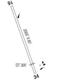
| Runways: | 16/34 |
| Longest Runway: | 16/34 is 2000 ft (610 m) long |
| Runways with an Instrument Approach: |
4S4 Airport Runway Details
| Runway 16/34 | 2000 ft x 45 ft (610 m x 14 m) | |
| Surface: | Turf - Good condition - No special surface treatment | |
Runway 16 |
Runway 34 |
|
Glide Path Angle: |
0.0 degrees | 0.0 degrees |
Traffic Pattern: |
Right | Left |
Object at End: |
TREES | ROAD |
Object Height: |
112 | 15 |
Distance from End: |
2022 | 45 |
Object Centerline Offset: |
0 ft. left and right of centerline | 0 ft. left and right of centerline |
Displaced Threshold: |
200 |
Services
Airframe Repair: |
Major |
Powerplant Repair: |
Minor |
Bottled Oxygen: |
None |
Bulk Oxygen: |
None |
Fuel Available: |
100LL, Jet A |
Landing Fees: |
No |
Parking: |
Tiedowns available |
Maps & Diagrams
4S4 Sectional
Flight Planning
at skyvector.com
at skyvector.com