Location
Latitude: |
45-46-15.7000N (45.771028) |
Longitude: |
122-51-42.6000W (-122.861833) |
Elevation: |
58.1 feet MSL (18 m MSL) |
Magnetic Variation: |
14.9 E (as of April 2024 from WMM2020 model) |
Time Zone: |
UTC -8.0 (Standard Time) UTC -7.0 (Daylight Savings Time) |
From City: |
01 N.M. NE of Scappoose, Oregon |
Found On: |
Seattle Chart |
FAA Region: |
ANM |
Contacts
Manager: |
Publicly owned: |
| CRAIG ALLISON PO BOX 190 COLUMBIA CITY, OR 97018 503-397-2888 |
PORT OF COLUMBIA COUNTY PO BOX 190 COLUMBIA CITY, OR 97018 503-397-2888 |
Operations
Airport Status: |
Operational |
Facility Use: |
Public |
Type: |
Airport |
Activation Date: |
11/1943 |
Control tower: |
No |
Attendance (Months/Days/Hours): |
Months/Days/Hours ALL/ALL/0800-DUSK |
Boundary ARTCC: |
ZSE (Seattle) |
Responsible ARTCC: |
ZSE (Seattle) |
Lighting Schedule: |
SEE RMK |
Segmented Circle Indicator: |
Yes |
Traffic Pattern Altitude (MSL): |
1058 feet (322 m) |
NOTAMs Facility: |
SPB |
NOTAM-D Service: |
Yes |
International Airport of Entry: |
No |
Customs Landing Rights: |
No |
Military Landing Rights: |
Yes |
Civil/Military Joint Use: |
No |
Based Aircraft
| Single Engine: | 106 |
| Multi Engine: | 1 |
| GA Helicopters: | 3 |
| Gliders: | 2 |
Annual Operations (as of 09/27/2021)
| Total Operations: | 60000 | |
| Air Taxi: | 2500 | 4.2% |
| GA Local: | 23400 | 39.0% |
| GA Itinerant: | 33500 | 55.8% |
| Military Aircraft: | 600 | 1.0% |
Communications
| CTAF: | 122.800 |
| Unicom: | 122.800 |
| Clearance Del.: | 121.65 121.65 121.65 121.65 |
| Approach: | PORTLAND |
| Departure: | PORTLAND |
| ASOS: | 135.875 (503-543-6401) |
Fixed Based Operators (FBOs) & Fuel
(Click on a business for detail)
Please help us keep this information up to date. This is a FREE SERVICE just like everything else on Airport Guide! If you see that a business needs to be added, modified, or deleted please fill out our Update Form.
To add, modify, or delete a business click here.
Please help us keep this information up to date. This is a FREE SERVICE just like everything else on Airport Guide! If you see that a business needs to be added, modified, or deleted please fill out our Update Form.
Area Code: 503 |
| Business Name | Frequency | Phone | Fuel Grade |
|---|---|---|---|
| Akro Tech Aviation
Update FBO info |
543-7960 | ||
| Oregon Aero, Inc.
Update FBO info |
543-7399 | ||
| Sport Copters
Update FBO info |
543-7000 | ||
| TransWestern Aviation, Inc.
Website Update FBO info |
Unicom 122.8 | 1-503-543-3121 | 100LL, Jet A |
Flight Service Stations
| Primary | Alternate | |
| FSS on Field: | N | |
| FSS Name (ID): | Mc Minnville(MMV) | |
| Frequency: | ||
| Toll Free Phone: | 1-800-WX-BRIEF |
Instrument Procedures / Charts
FAA Terminal Procedures valid from 0901Z 03/21/24 to 0901Z 04/18/24.
There are various types of charts available for an airport. They are listed in the Page Type column. Here is a legend for those types:
APD - Airport Diagram
DP - Departure Procedure Charts
HOT - Hot Spots
IAP - Instrument Approach Procedure Charts
MIN - Minimums
STAR - Standard Terminal Arrival Charts
| Page Type | Page Name | Volume | Action Since Last Cycle |
|---|---|---|---|
| IAP | LOC/DME RWY 15 | NW-1 | |
| IAP | RNAV (GPS) RWY 15 | NW-1 | |
| IAP | VOR/DME-A | NW-1 | |
| MIN | ALTERNATE MINIMUMS | NW-1 | |
| MIN | DIVERSE VECTOR AREA | NW-1 | |
| MIN | TAKEOFF MINIMUMS | NW-1 |
Terminal Procedures are only available for airports in several countries with more being added all the time. If you are looking for a specific country's charts, please send an email to support(at)airportguide.com stating the country name. This will be used to prioritize the implementation.
Navigation Aids (Navaids) near KSPB
| Dist (NM) | ID | Morse Code | Name | Type | Freq | True Hdg | Mag Hdg |
|---|---|---|---|---|---|---|---|
| 11.4 | BTG | _ . . . _ _ _ . | Battle Ground | VORTAC | 116.60 | 96 | 81 |
| 11.4 | PND | . _ _ . _ . _ . . | Banks | NDB | 356 | 222 | 207 |
| 14.3 | HIO | . . . . . . _ _ _ | Hillsboro | VOT | 115.20 | 194 | 179 |
| 15.1 | PDX | . _ _ . _ . . _ . . _ | Portland | VOT | 111.00 | 133 | 118 |
| 15.1 | PDX | . _ _ . _ . . _ . . _ | Portland | VOR-DME | 111.80 | 134 | 119 |
| 15.2 | CBU | _ . _ . _ . . . . . _ | Columbia | TACAN | 109.20 | 136 | 121 |
| 21.7 | LBH | . _ . . _ . . . . . . . | Laker | NDB | 332 | 129 | 114 |
| 23.2 | LSO | . _ . . . . . _ _ _ | Kelso | NDB | 256 | 354 | 339 |
| 25.5 | UBG | . . _ _ . . . _ _ . | Newberg | VOR-DME | 117.40 | 191 | 176 |
| 37.5 | PEN | . _ _ . . _ . | Karpen | NDB | 201 | 306 | 291 |
| 48.5 | AST | . _ . . . _ | Astoria | VOR-DME | 114.00 | 299 | 284 |
| 53.0 | AST | . _ . . . _ | Fort Stevens | FAN MARKER | 300 | 285 | |
| 55.5 | SL | . . . . _ . . | Turno | NDB | 266 | 183 | 168 |
| 71.6 | LWG | . _ . . . _ _ _ _ . | Lewisburg | NDB | 225 | 194 | 179 |
| 72.1 | OLM | _ _ _ . _ . . _ _ | Olympia | VORTAC | 113.40 | 358 | 343 |
| 73.8 | LTJ | . _ . . _ . _ _ _ | Klickitat | VOR-DME | 112.30 | 92 | 77 |
| 75.3 | LAC | . _ . . . _ _ . _ . | Lacomas | NDB | 328 | 9 | 354 |
| 78.4 | CVO | _ . _ . . . . _ _ _ _ | Corvallis | VOR-DME | 115.40 | 193 | 178 |
| 83.4 | GRF | _ _ . . _ . . . _ . | Graye | NDB | 216 | 7 | 352 |
| 84.1 | TCM | _ _ . _ . _ _ | Mcchord | TACAN | 109.60 | 10 | 355 |
Nearby Airports with Fuel
Notices to Airmen (NOTAMS)
Remarks
| A110*G | THIS AIRPORT HAS BEEN SURVEYED BY THE NATIONAL GEODETIC SURVEY. |
| A110-1 | BLUE LGTS & CNTRLN REFLECTORS AT EAST SIDE TWY EXITS FM RWY. |
| A110-2 | EXTENSIVE ULTRALIGHT ACTIVITY ON WEST SIDE PARALLEL TWY. |
| A110-3 | RUNWAY 33 HAS BASIC MARKINGS PLUS AIMING POINTS |
| A110-4 | TWY B HAS MED INTST TWY LGTS. |
| A110-5 | FOR CD CTC PORTLAND APPROACH AT 503-493-7545. |
| A110-6 | RWY 15 IS CALM WND RWY |
| A81-APT | ACTVT REIL RWY 15; PAPI RWY 15 AND 33; MIRL RWY 15/33; - CTAF. 7 CLICKS TO ACTVT REIL. |
Runways
Runway Summary
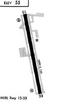
| Runways: | 15/33 |
| Longest Runway: | 15/33 is 5100 ft (1554 m) long |
| Runways with an Instrument Approach: | 15 |
KSPB Airport Runway Details
| Runway 15/33 | 5100 ft x 100 ft (1554 m x 30 m) | |
| Runway Length Source: | NGS as of 04/09/2006 | |
| Surface: | Asphalt - Fair condition - No special surface treatment | |
| Runway Edge Lights: | Medium Intensity | |
Runway Weight Bearing Capacity (in thousands of pounds) |
||
| Single Wheel Landing Gear: | 30.0 | |
| Dual Wheel Landing Gear: | 50.0 | |
| Dual Tandem Wheel Landing Gear: | 90.0 | |
Runway 15 |
Runway 33 |
|
Elevation: |
58.1 | 30.0 |
Latitude: |
45-46-40.4083N | 45-45-51.0442N |
Longitude: |
122-51-49.6531W | 122-51-35.4943W |
|
Runway True Alignment: |
169 | 349 |
ILS Type: |
LOC/DME | |
Glide Path Angle: |
3.7 degrees | 3.0 degrees |
Traffic Pattern: |
Left | Right |
Runway Markings Type: |
Nonprecision Instrument | Nonprecision Instrument |
Runway Markings Condition: |
Fair | Good |
Object at End: |
TREE | |
Object Height: |
49 | |
Distance from End: |
477 | |
Object Centerline Offset: |
325 ft. right of centerline | |
Visual Glide Slope Indicators: |
4-Light PAPI On Left Side Of Runway | 4-Light PAPI On Left Side Of Runway |
REIL: |
Yes | |
Threshold Crossing Height: |
41 | 40 |
Services
Airframe Repair: |
Major |
Powerplant Repair: |
Major |
Bottled Oxygen: |
Low Pressure |
Bulk Oxygen: |
None |
Fuel Available: |
100LL, Jet A |
Landing Fees: |
No |
Parking: |
Tiedowns available |
Maps & Diagrams
KSPB Sectional
Flight Planning
at skyvector.com
at skyvector.com