Location
Latitude: |
45-32-57.7000N (45.549361) |
Longitude: |
122-24-04.5000W (-122.40125) |
Elevation: |
38.9 feet MSL (12 m MSL) |
Magnetic Variation: |
14.8 E (as of April 2024 from WMM2020 model) |
Time Zone: |
UTC -8.0 (Standard Time) UTC -7.0 (Daylight Savings Time) |
From City: |
10 N.M. E of Portland, Oregon |
Found On: |
Seattle Chart |
FAA Region: |
ANM |
Contacts
Manager: |
Publicly owned: |
| KAMA SIMONDS PORT OF PORTLAND BOX 3529 PORTLAND, OR 97208 503-415-6119 |
THE PORT OF PORTLAND BOX 3529 PORTLAND, OR 97208 503-944-7000 |
Operations
Airport Status: |
Operational |
Facility Use: |
Public |
Type: |
Airport |
Activation Date: |
02/1939 |
Control tower: |
Yes |
Attendance (Months/Days/Hours): |
Months/Days/Hours ALL/ALL/0700-2200 |
Boundary ARTCC: |
ZSE (Seattle) |
Responsible ARTCC: |
ZSE (Seattle) |
Lighting Schedule: |
SEE RMK |
Segmented Circle Indicator: |
Yes |
Traffic Pattern Altitude (MSL): |
1039 feet (317 m) |
NOTAMs Facility: |
TTD |
NOTAM-D Service: |
Yes |
International Airport of Entry: |
No |
Customs Landing Rights: |
No |
Military Landing Rights: |
Yes |
Civil/Military Joint Use: |
No |
Based Aircraft
| Single Engine: | 60 |
| Multi Engine: | 2 |
| GA Helicopters: | 11 |
Annual Operations (as of 07/16/2020)
| Total Operations: | 105020 | |
| Air Taxi: | 4000 | 3.8% |
| GA Local: | 70000 | 66.7% |
| GA Itinerant: | 29520 | 28.1% |
| Military Aircraft: | 1500 | 1.4% |
Communications
| CTAF: | 120.900 |
| Unicom: | 122.950 |
| Tower: | TROUTDALE 120.9 254.3 Hrs: 0700-2200 |
| Ground: | 121.8 |
| Approach: | PORTLAND |
| Departure: | PORTLAND |
| ATIS: | 135.625 Hrs: 24 |
| ASOS: | 135.625 (503-492-2887) |
Fixed Based Operators (FBOs) & Fuel
(Click on a business for detail)
Please help us keep this information up to date. This is a FREE SERVICE just like everything else on Airport Guide! If you see that a business needs to be added, modified, or deleted please fill out our Update Form.
To add, modify, or delete a business click here.
Please help us keep this information up to date. This is a FREE SERVICE just like everything else on Airport Guide! If you see that a business needs to be added, modified, or deleted please fill out our Update Form.
Area Code: 503 |
| Business Name | Frequency | Phone | Fuel Grade |
|---|---|---|---|
| Engine Components Northwest
Update FBO info |
674-2424 | ||
| Gorge Winds Aviation
Update FBO info |
665-2823 | ||
| Premier Aircraft Engines
Update FBO info |
661-4184 | 100LL, Jet A | |
| Right Approach Aviation
Update FBO info |
667-4219 | ||
| Skyline Radio
Update FBO info |
492-7600 | ||
| Troutdale Aircraft Services II
Update FBO info |
666-3838 | ||
| Troutdale Avionics
Update FBO info |
492-4335 | ||
| Western Aircraft Propeller Service
Update FBO info |
667-8865 |
Flight Service Stations
| Primary | Alternate | |
| FSS on Field: | N | |
| FSS Name (ID): | Mc Minnville(MMV) | |
| Frequency: | ||
| Toll Free Phone: | 1-800-WX-BRIEF |
Instrument Procedures / Charts
FAA Terminal Procedures valid from 0901Z 03/21/24 to 0901Z 04/18/24.
There are various types of charts available for an airport. They are listed in the Page Type column. Here is a legend for those types:
APD - Airport Diagram
DP - Departure Procedure Charts
HOT - Hot Spots
IAP - Instrument Approach Procedure Charts
MIN - Minimums
STAR - Standard Terminal Arrival Charts
| Page Type | Page Name | Volume | Action Since Last Cycle |
|---|---|---|---|
| APD | AIRPORT DIAGRAM | NW-1 | |
| DP | BLUE LAKE THREE | NW-1 | |
| IAP | RNAV (GPS)-A | NW-1 | |
| MIN | ALTERNATE MINIMUMS | NW-1 | |
| MIN | DIVERSE VECTOR AREA | NW-1 | |
| MIN | TAKEOFF MINIMUMS | NW-1 | |
| STAR | HELNS SIX | NW-1 | |
| STAR | OCITY THREE | NW-1 |
Terminal Procedures are only available for airports in several countries with more being added all the time. If you are looking for a specific country's charts, please send an email to support(at)airportguide.com stating the country name. This will be used to prioritize the implementation.
Navigation Aids (Navaids) near TTD
| Dist (NM) | ID | Morse Code | Name | Type | Freq | True Hdg | Mag Hdg |
|---|---|---|---|---|---|---|---|
| 2.6 | LBH | . _ . . _ . . . . . . . | Laker | NDB | 332 | 259 | 244 |
| 9.0 | PDX | . _ _ . _ . . _ . . _ | Portland | VOT | 111.00 | 288 | 273 |
| 9.0 | PDX | . _ _ . _ . . _ . . _ | Portland | VOR-DME | 111.80 | 287 | 272 |
| 9.1 | CBU | _ . _ . _ . . . . . _ | Columbia | TACAN | 109.20 | 285 | 270 |
| 14.3 | BTG | _ . . . _ _ _ . | Battle Ground | VORTAC | 116.60 | 326 | 311 |
| 23.0 | HIO | . . . . . . _ _ _ | Hillsboro | VOT | 115.20 | 268 | 253 |
| 27.0 | UBG | . . _ _ . . . _ _ . | Newberg | VOR-DME | 117.40 | 244 | 229 |
| 27.5 | PND | . _ _ . _ . _ . . | Banks | NDB | 356 | 280 | 265 |
| 42.2 | LSO | . _ . . . . . _ _ _ | Kelso | NDB | 256 | 329 | 314 |
| 48.1 | SL | . . . . _ . . | Turno | NDB | 266 | 209 | 194 |
| 55.4 | LTJ | . _ . . _ . _ _ _ | Klickitat | VOR-DME | 112.30 | 79 | 64 |
| 60.9 | PEN | . _ _ . . _ . | Karpen | NDB | 201 | 305 | 290 |
| 67.1 | LWG | . _ . . . _ _ _ _ . | Lewisburg | NDB | 225 | 213 | 198 |
| 71.9 | AST | . _ . . . _ | Astoria | VOR-DME | 114.00 | 301 | 286 |
| 73.5 | CVO | _ . _ . . . . _ _ _ _ | Corvallis | VOR-DME | 115.40 | 211 | 196 |
| 76.4 | AST | . _ . . . _ | Fort Stevens | FAN MARKER | 301 | 286 | |
| 87.4 | EU | . . . _ | Frakk | NDB | 260 | 203 | 188 |
| 87.8 | LAC | . _ . . . _ _ . _ . | Lacomas | NDB | 328 | 355 | 340 |
| 87.8 | OLM | _ _ _ . _ . . _ _ | Olympia | VORTAC | 113.40 | 346 | 331 |
| 90.7 | DSD | _ . . . . . _ . . | Deschutes | VORTAC | 117.60 | 148 | 133 |
Nearby Airports with Fuel
Notices to Airmen (NOTAMS)
Remarks
| A110-1 | MIGRATORY FLOCKSOF WATERFOWL ON & INVOF ARPT. |
| A110-10 | FOR CD CTC PORTLAND APCH AT 503-493-7545. |
| A110-2 | PORTLAND INTL ARPT RY 10L/28R EXTNDD CENTERLINE CROSSES ARPT, ATCT MAY ISSUE RESTRICCTIONS DUE TO PDX TFC. |
| A110-3 | NOISE ABATEMENT PROCEDURES IN EFFECT. CALL 503-460-4100 OR 800-938-6647. |
| A110-4 | NOISE SENSITIVE AREAS BORDER THE ARPT WEST AND SOUTH. |
| A110-5 | AVOID LOW-LEVEL OVERFLIGHTS OF RESIDENTIAL AREAS. |
| A110-6 | RECOMMEND BETWEEN SS AND SR, RY 7 LEFT TFC AND RY 25 RIGHT TFC DUE TO BLUFF 5000 FT SOUTH OF ARPT. |
| A110-7 | EXTENSIVE HELICOPTER OPS ON AND ADJACENT TO WEST ENDS OF THE PARALLEL TWYS, NO EARLY TURNOUTS. |
| A110-9 | MULTIPLE CONST CRANES 110 FT AGL OR BLO LOCATED 2700 FT SW OF RY 25 THLD. |
| A24 | COMMERCIAL ACFT & OPERATORS OF ACFT WITH AN FAA CERTIFIED MAX GROSS LANDING WEIGHT THAT EXCEEDS 10000 LBS ARE REQUIRED TO PAY A LANDING FEE. |
| A43-25 | RY 25 PAPI IS BAFFLED 08 DEG L AND R OF CNTRLN. |
| A52-25 | APCH RATIO 27:1; DIKE AT 588' LGTD. |
| A57-07 | APCH CLNC SLOPE FROM DTHR IS 45:1 BASED ON 21' ROAD AT 817'. |
| A81-APT | ACTVT MIRL RY 07/25 - CTAF. RY 07 VASI & RY 25 PAPI OPER CONT. |
| E111 | ESTABD PRIOR TO 1959. |
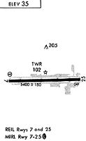
Runways
Runway Summary
| Runways: | 07/25 |
| Longest Runway: | 07/25 is 5399 ft (1646 m) long |
| Runways with an Instrument Approach: |
TTD Airport Runway Details
| Runway 07/25 | 5399 ft x 150 ft (1646 m x 46 m) | |
| Runway Length Source: | OWNER as of 10/21/2014 | |
| Surface: | Asphalt - Good condition - No special surface treatment | |
| Runway Edge Lights: | Medium Intensity | |
Runway Weight Bearing Capacity (in thousands of pounds) |
||
| Single Wheel Landing Gear: | 19.0 | |
| Dual Wheel Landing Gear: | 25.0 | |
Runway 07 |
Runway 25 |
|
Elevation: |
27.8 | 38.9 |
Latitude: |
45-32-57.1194N | 45-32-58.3423N |
Longitude: |
122-24-42.4256W | 122-23-26.5864W |
|
Runway True Alignment: |
089 | 269 |
Glide Path Angle: |
3.0 degrees | 3.1 degrees |
Traffic Pattern: |
Left | Left |
Runway Markings Type: |
Nonprecision Instrument | Nonprecision Instrument |
Runway Markings Condition: |
Good | Good |
Object at End: |
TREES | TREES |
Object Height: |
105 | 63 |
Distance from End: |
2100 | 1653 |
Object Centerline Offset: |
0 ft. left and right of centerline | 0 ft. left and right of centerline |
Visual Glide Slope Indicators: |
4-Box VASI On Left Side Of Runway | 4-Light PAPI On Left Side Of Runway |
REIL: |
Yes | Yes |
Threshold Crossing Height: |
50 | 31 |
Threshold Elevation: |
38.0 | |
Displaced Threshold: |
353 | |
Threshold Latitude: |
45-32-58.2637N | |
Threshold Longitude: |
122-23-31.5448W | |
Declared Distances |
||
Take Off Run Avbl. (TORA): |
5399 | |
Take Off Distance Avbl. (TODA): |
5399 | |
Actual Stop Dist. Avbl. (ASDA): |
5399 | |
Landing Dist. Avbl. (LDA): |
5046 | |
Services
Airframe Repair: |
Minor |
Powerplant Repair: |
Minor |
Bottled Oxygen: |
None |
Bulk Oxygen: |
None |
Fuel Available: |
100LL |
Landing Fees: |
No |
Parking: |
Tiedowns available |
Maps & Diagrams
TTD Sectional
Flight Planning
at skyvector.com
at skyvector.com