
Location
Latitude: |
41-20-18.5000N (41.338472) |
Longitude: |
075-43-24.2000W (-75.723389) |
Elevation: |
961.7 feet MSL (293 m MSL) |
Magnetic Variation: |
11.9 W (as of May 2024 from WMM2020 model) |
Time Zone: |
UTC -5.0 (Standard Time) UTC -4.0 (Daylight Savings Time) |
From City: |
05 N.M. SW of Wilkes-Barre/Scranton, Pennsylvania |
Found On: |
New York Chart |
FAA Region: |
AEA |
Contacts
Manager: |
Publicly owned: |
| CARL R. BEARDSLEY, JR. 100 TERMINAL DRIVE AVOCA, PA 18641 570-602-2000 |
LUZERNE AND LACKAWANNA CO 100 TERMINAL DRIVE AVOCA, PA 18641 (570) 602-2040 |
Operations
Airport Status: |
Operational |
Facility Use: |
Public |
Type: |
Airport |
Activation Date: |
01/1947 |
Control tower: |
Yes |
Attendance (Months/Days/Hours): |
Months/Days/Hours ALL/ALL/ALL |
Boundary ARTCC: |
ZNY (New York) |
Responsible ARTCC: |
ZNY (New York) |
Segmented Circle Indicator: |
No |
Traffic Pattern Altitude (MSL): |
1962 feet (598 m) |
NOTAMs Facility: |
AVP |
NOTAM-D Service: |
Yes |
International Airport of Entry: |
No |
Customs Landing Rights: |
Yes |
Military Landing Rights: |
Yes |
Civil/Military Joint Use: |
No |
Aircraft Rescue and Firefighting: |
Class I ARFF Index: B Air Carrier Service: Scheduled Certification Date: 05/1973 |
Based Aircraft
| Single Engine: | 24 |
| Multi Engine: | 6 |
| Jet Engine: | 1 |
| GA Helicopters: | 2 |
Annual Operations (as of 12/31/2022)
| Total Operations: | 43495 | |
| Commercial: | 3341 | 7.7% |
| Air Taxi: | 7574 | 17.4% |
| GA Local: | 20745 | 47.7% |
| GA Itinerant: | 11441 | 26.3% |
| Military Aircraft: | 394 | 0.9% |
Communications
| Unicom: | 122.950 |
| Tower: | WILKES-BARRE 120.1 257.8 Hrs: 24 |
| Ground: | 121.9 |
| Approach: | WILKES-BARRE 120.95 ;280-100 126.3 ;101-279 256.7 Hrs: 24 |
| Departure: | WILKES-BARRE 120.95 ;280-100 126.3 ;101-279 256.7 Hrs: 24 |
| ATIS: | 135.75 Hrs: 24 |
| ASOS: | (570-655-0748) |
| TRSA: | 256.7 |
| TRSA: | 120.95 ;280-100 |
| EMERG: | 121.5 |
| TRSA: | 126.3 ;101-279 |
| EMERG: | 243.0 |
Fixed Based Operators (FBOs) & Fuel
(Click on a business for detail)
Please help us keep this information up to date. This is a FREE SERVICE just like everything else on Airport Guide! If you see that a business needs to be added, modified, or deleted please fill out our Update Form.
To add, modify, or delete a business click here.
Please help us keep this information up to date. This is a FREE SERVICE just like everything else on Airport Guide! If you see that a business needs to be added, modified, or deleted please fill out our Update Form.
Area Code: 570 |
| Business Name | Frequency | Phone | Fuel Grade |
|---|---|---|---|
| Tech Aviation
Update FBO info |
Unicom 122.95 | 457-3400, 655-5999 | 100LL, Jet A |
Flight Service Stations
| Primary | Alternate | |
| FSS on Field: | ||
| FSS Name (ID): | Williamsport(IPT) | |
| Frequency: | ||
| Toll Free Phone: | 1-800-WX-BRIEF |
Instrument Procedures / Charts
FAA Terminal Procedures valid from 0901Z 03/21/24 to 0901Z 04/18/24.
There are various types of charts available for an airport. They are listed in the Page Type column. Here is a legend for those types:
APD - Airport Diagram
DP - Departure Procedure Charts
HOT - Hot Spots
IAP - Instrument Approach Procedure Charts
MIN - Minimums
STAR - Standard Terminal Arrival Charts
| Page Type | Page Name | Volume | Action Since Last Cycle |
|---|---|---|---|
| APD | AIRPORT DIAGRAM | NE-4 | |
| DP | SCRANTON EIGHT | NE-4 | |
| IAP | ILS OR LOC RWY 04 | NE-4 | |
| IAP | ILS OR LOC RWY 22 | NE-4 | |
| IAP | RNAV (GPS) RWY 04 | NE-4 | |
| IAP | RNAV (GPS) RWY 22 | NE-4 | |
| MIN | ALTERNATE MINIMUMS | NE-4 | |
| MIN | TAKEOFF MINIMUMS | NE-4 |
Terminal Procedures are only available for airports in several countries with more being added all the time. If you are looking for a specific country's charts, please send an email to support(at)airportguide.com stating the country name. This will be used to prioritize the implementation.
Navigation Aids (Navaids) near AVP
| Dist (NM) | ID | Morse Code | Name | Type | Freq | True Hdg | Mag Hdg |
|---|---|---|---|---|---|---|---|
| 4.2 | LVZ | . _ . . . . . _ _ _ . . | Wilkes-Barre | VORTAC | 111.60 | 158 | 170 |
| 13.6 | LHY | . _ . . . . . . _ . _ _ | Lake Henry | VORTAC | 110.80 | 52 | 64 |
| 28.4 | HZL | . . . . _ _ . . . _ . . | Hazleton | VOR | 109.40 | 219 | 231 |
| 38.7 | FJC | . . _ . . _ _ _ _ . _ . | Allentown | VORTAC | 117.50 | 161 | 173 |
| 43.7 | STW | . . . _ . _ _ | Stillwater | VOR-DME | 109.60 | 117 | 129 |
| 44.6 | PIX | . _ _ . . . _ . . _ | Picture Rocks | NDB | 344 | 265 | 277 |
| 45.5 | ETX | . _ _ . . _ | East Texas | VOR-DME | 110.20 | 177 | 189 |
| 46.5 | MS | _ _ . . . | Monga | NDB | 359 | 56 | 68 |
| 46.5 | MIP | _ _ . . . _ _ . | Milton | VORTAC | 109.20 | 246 | 258 |
| 46.6 | BG | _ . . . _ _ . | Smite | NDB | 332 | 350 | 362 |
| 47.1 | HNK | . . . . _ . _ . _ | Hancock | VOR-DME | 116.80 | 22 | 34 |
| 47.4 | FQM | . . _ . _ _ . _ _ _ | Williamsport | VOR-DME | 114.40 | 270 | 282 |
| 51.1 | HUO | . . . . . . _ _ _ _ | Huguenot | VOR-DME | 116.10 | 84 | 96 |
| 52.1 | BWZ | _ . . . . _ _ _ _ . . | Broadway | VOR-DME | 114.20 | 128 | 140 |
| 52.5 | CFB | _ . _ . . . _ . _ . . . | Binghamton | VOR-DME | 112.20 | 339 | 351 |
| 55.9 | SAX | . . . . _ _ . . _ | Sparta | VORTAC | 115.70 | 106 | 118 |
| 58.1 | UKT | . . _ _ . _ _ | Quakertown | NDB | 208 | 160 | 172 |
| 61.0 | DNY | _ . . _ . _ . _ _ | Delancey | VOR-DME | 112.10 | 33 | 45 |
| 61.6 | RAV | . _ . . _ . . . _ | Ravine | VORTAC | 114.60 | 220 | 232 |
| 61.9 | SEG | . . . . _ _ . | Selinsgrove | VOR-DME | 110.40 | 238 | 250 |
Nearby Airports with Fuel
Notices to Airmen (NOTAMS)
Remarks
| A110-2 | DEER & BIRDS ON & INVOF ARPT. |
| A110-5 | RY 28 UNLGTD HIGH TERRAIN TREES: 1155 FT MSL .91 MI EAST AER 28; 1463 FT MSL 1.49 MI EAST-SOUTHEAST AER 28; 1667 FT MSL 2.25 MI EAST AER 28; 1920 FT MSL 2.84 MI EAST AER 28. |
| A110-6 | UNLGTD TOWER 1130 FT MSL (20 FT AGL) 1.3 MI EAST AER 28; UNLGTD TOWER 1463 FT MSL (20 FT AGL) 1.7 MI EAST AER 28; UNLGTD TOWER 1652 FT MSL (20 FT AGL) 2.4 MI EAST AER 28. |
| A110-7 | FOR FBO SERVICE 0000-0500 LOCAL M-F AND 2100-0000 LOCAL SAT-SUN CALL (570) 457-4485. |
| A26 | INDEX 'C' ARFF EQUIPMENT AVAILABLE UPON REQUEST CALL 570-602-2040. |
| A30-04/22 | PRECIPITOUS DROP-OFF EACH RY END. |
| E111 | EXISTED PRIOR TO REQMT FOR AIRSPACE DETER. |
| E60-04 | ENGINEERED MATERIAL ARRESTING SYSTEM (EMAS) 324 FT IN LENGTH BY 170 FT IN WIDTH LCTD 50 FT OFF DER 04. |
| E60-22 | ENGINEERED MATERIAL ARRESTING SYSTEM (EMAS) 162 FT IN LENGTH BY 170 FT IN WIDTH LCTD 35 FT OFF DER 22. |
Runways
Runway Summary
| Runways: | 04/22 10/28 |
| Longest Runway: | 04/22 is 7502 ft (2287 m) long |
| Runways with an Instrument Approach: | 04, 22 |
AVP Airport Runway Details
| Runway 04/22 | 7502 ft x 150 ft (2287 m x 46 m) | |
| Runway Length Source: | 3RD PARTY SURVEY as of 05/03/2016 | |
| Surface: | Asphalt - Good condition - Saw-cut or plastic grooved | |
| Runway Pavement Class: | 45 /F/A/X/T | |
| Runway Edge Lights: | High Intensity | |
Runway Weight Bearing Capacity (in thousands of pounds) |
||
| Single Wheel Landing Gear: | 133.0 | |
| Dual Wheel Landing Gear: | 173.0 | |
| Dual Tandem Wheel Landing Gear: | 300.0 | |
Runway 04 |
Runway 22 |
|
Elevation: |
961.7 | 911.3 |
Latitude: |
41-19-43.3121N | 41-20-45.6805N |
Longitude: |
075-43-53.5129W | 075-43-00.3877W |
|
Runway True Alignment: |
033 | 213 |
ILS Type: |
ILS/DME | ILS/DME |
Glide Path Angle: |
3.0 degrees | 3.0 degrees |
Traffic Pattern: |
Left | Right |
Runway Markings Type: |
Precision Instrument | Precision Instrument |
Runway Markings Condition: |
Good | Good |
Arresting Device: |
EMAS | EMAS |
Object at End: |
TOWER | |
Object Height: |
155 | |
Distance from End: |
6529 | |
Object Centerline Offset: |
686 ft. right of centerline | |
Visual Glide Slope Indicators: |
4-Light PAPI On Right Side Of Runway | 4-Box VASI On Left Side Of Runway |
Runway Visual Range (RVR): |
Touchdown, Rollout | Touchdown, Rollout |
Approach Light System: |
1,400 Foot Medium Intensity Approach Lighting System With Runway Alignment Indicator Lights | |
REIL: |
Yes | |
Threshold Crossing Height: |
58 | 54 |
Declared Distances |
||
Take Off Run Avbl. (TORA): |
7502 | 7502 |
Take Off Distance Avbl. (TODA): |
7502 | 7502 |
Actual Stop Dist. Avbl. (ASDA): |
7502 | 7502 |
Landing Dist. Avbl. (LDA): |
7502 | 7502 |
| Runway 10/28 | 4300 ft x 150 ft (1311 m x 46 m) | |
| Runway Length Source: | 3RD PARTY SURVEY as of 05/03/2016 | |
| Surface: | Asphalt - Good condition - Saw-cut or plastic grooved | |
| Runway Pavement Class: | 34 /F/C/X/T | |
| Runway Edge Lights: | Medium Intensity | |
Runway Weight Bearing Capacity (in thousands of pounds) |
||
| Single Wheel Landing Gear: | 58.0 | |
| Dual Wheel Landing Gear: | 80.0 | |
| Dual Tandem Wheel Landing Gear: | 125.0 | |
Runway 10 |
Runway 28 |
|
Elevation: |
921.9 | 934.5 |
Latitude: |
41-20-26.1660N | 41-20-24.8860N |
Longitude: |
075-43-47.6614W | 075-42-51.3140W |
|
Runway True Alignment: |
092 | 272 |
Glide Path Angle: |
3.0 degrees | 0.0 degrees |
Traffic Pattern: |
Right | Right |
Runway Markings Type: |
Nonprecision Instrument | Nonprecision Instrument |
Runway Markings Condition: |
Good | Good |
Object at End: |
TREES | |
Object Height: |
59 | |
Distance from End: |
613 | |
Object Centerline Offset: |
686 ft. right of centerline | |
Visual Glide Slope Indicators: |
2-Light PAPI On Left Side Of Runway | |
REIL: |
Yes | Yes |
Threshold Crossing Height: |
43 | |
Declared Distances |
||
Take Off Run Avbl. (TORA): |
4300 | 4300 |
Take Off Distance Avbl. (TODA): |
4300 | 4300 |
Actual Stop Dist. Avbl. (ASDA): |
4300 | 4300 |
Landing Dist. Avbl. (LDA): |
4300 | 4300 |
Services
Airframe Repair: |
Minor |
Powerplant Repair: |
Minor |
Bottled Oxygen: |
High Pressure / Low Pressure |
Bulk Oxygen: |
None |
Fuel Available: |
100LL, Jet A |
Landing Fees: |
Yes |
Parking: |
Hangars and tiedowns available |
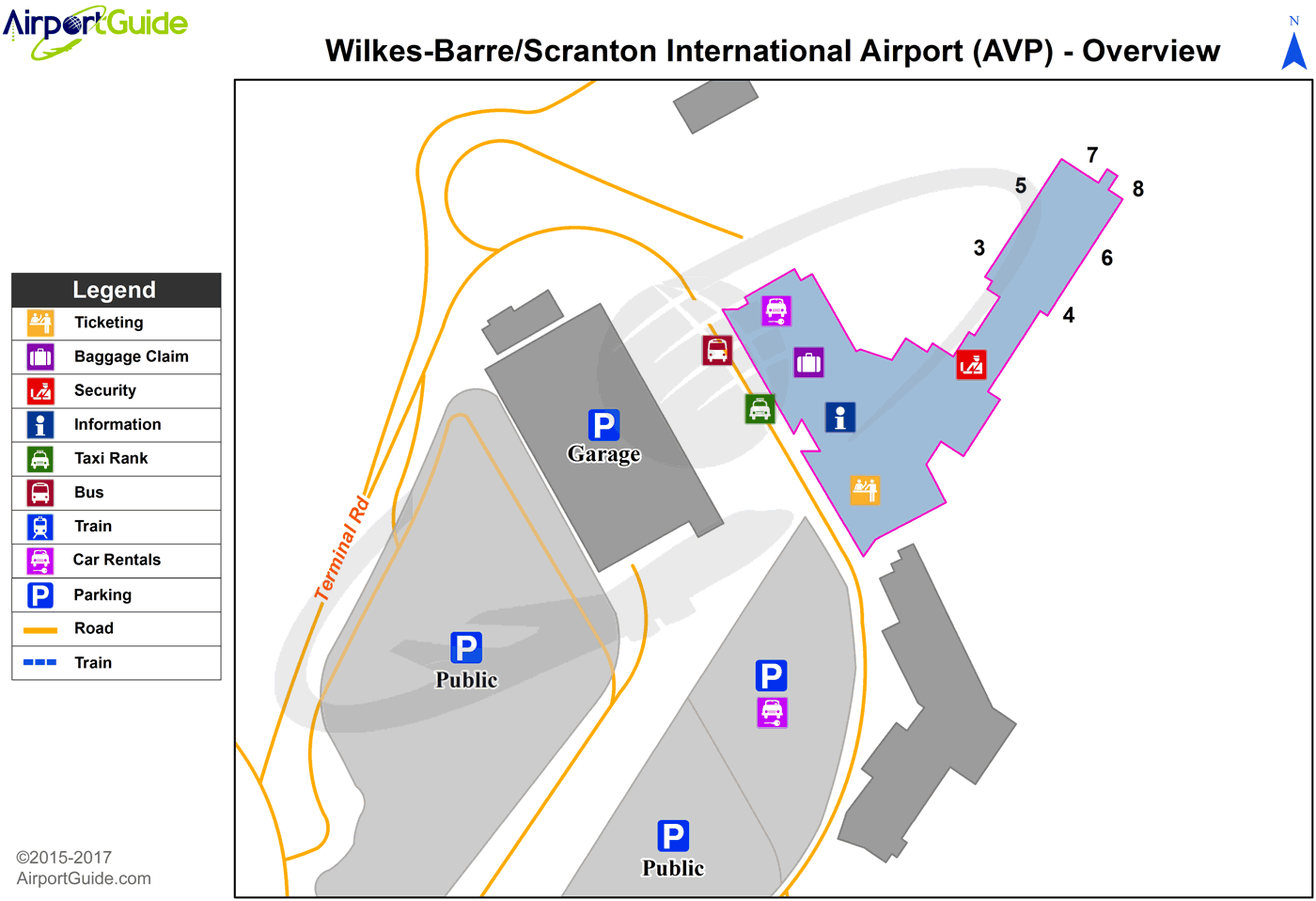
Maps & Diagrams
AVP Sectional
Flight Planning
at skyvector.com
at skyvector.com
 Diagram")