Location
Latitude: |
40-50-39.4350N (40.844288) |
Longitude: |
075-38-07.2750W (-75.635354) |
Elevation: |
899.0 feet MSL (274 m MSL) |
Magnetic Variation: |
11.8 W (as of May 2024 from WMM2020 model) |
Time Zone: |
UTC -5.0 (Standard Time) UTC -4.0 (Daylight Savings Time) |
From City: |
03 N.M. E of Lehighton, Pennsylvania |
Found On: |
New York Chart |
FAA Region: |
AEA |
Contacts
Manager: |
Privately owned: |
| RICHARD D. BELTZ 357 AIRPORT ROAD LEHIGHTON, PA 18235 610-377-1996 |
RICHARD BELTZ 357 AIRPORT RD LEHIGHTON, PA 18235 610-377-1996 |
Operations
Airport Status: |
Operational |
Facility Use: |
Public |
Type: |
Airport |
Activation Date: |
12/1949 |
Control tower: |
No |
Attendance (Months/Days/Hours): |
Months/Days/Hours IREG |
Boundary ARTCC: |
ZNY (New York) |
Responsible ARTCC: |
ZNY (New York) |
Segmented Circle Indicator: |
No |
Traffic Pattern Altitude (MSL): |
1899 feet (579 m) |
NOTAMs Facility: |
IPT |
NOTAM-D Service: |
Yes |
International Airport of Entry: |
No |
Customs Landing Rights: |
No |
Military Landing Rights: |
No |
Civil/Military Joint Use: |
No |
Based Aircraft
| Single Engine: | 17 |
| Gliders: | 15 |
| Ultralights: | 4 |
Annual Operations (as of 03/29/2023)
| Total Operations: | 1530 | |
| GA Local: | 1500 | 98.0% |
| GA Itinerant: | 30 | 2.0% |
Communications
| CTAF: | 122.900 |
Fixed Based Operators (FBOs) & Fuel
(Click on a business for detail)
Please help us keep this information up to date. This is a FREE SERVICE just like everything else on Airport Guide! If you see that a business needs to be added, modified, or deleted please fill out our Update Form.
To add, modify, or delete a business click here.
Please help us keep this information up to date. This is a FREE SERVICE just like everything else on Airport Guide! If you see that a business needs to be added, modified, or deleted please fill out our Update Form.
Area Code: 610 |
| Business Name | Frequency | Phone | Fuel Grade |
|---|---|---|---|
| Beltzville Airport Enterprises, Inc.
Update FBO info |
377-9914, -4887 | 100LL |
Flight Service Stations
| Primary | Alternate | |
| FSS on Field: | N | |
| FSS Name (ID): | Williamsport(IPT) | |
| Frequency: | ||
| Toll Free Phone: | 1-800-WX-BRIEF |
Instrument Procedures / Charts
Terminal Procedures are only available for airports in several countries with more being added all the time. If you are looking for a specific country's charts, please send an email to support(at)airportguide.com stating the country name. This will be used to prioritize the implementation.
Navigation Aids (Navaids) near 14N
| Dist (NM) | ID | Morse Code | Name | Type | Freq | True Hdg | Mag Hdg |
|---|---|---|---|---|---|---|---|
| 10.8 | FJC | . . _ . . _ _ _ _ . _ . | Allentown | VORTAC | 117.50 | 130 | 142 |
| 16.0 | ETX | . _ _ . . _ | East Texas | VOR-DME | 110.20 | 187 | 199 |
| 23.6 | HZL | . . . . _ _ . . . _ . . | Hazleton | VOR | 109.40 | 289 | 301 |
| 25.8 | LVZ | . _ . . . . . _ _ _ . . | Wilkes-Barre | VORTAC | 111.60 | 354 | 366 |
| 29.5 | UKT | . . _ _ . _ _ | Quakertown | NDB | 208 | 148 | 160 |
| 35.9 | STW | . . . _ . _ _ | Stillwater | VOR-DME | 109.60 | 75 | 87 |
| 37.0 | BWZ | _ . . . . _ _ _ _ . . | Broadway | VOR-DME | 114.20 | 93 | 105 |
| 37.5 | PTW | . _ _ . _ . _ _ | Pottstown | VORTAC | 116.50 | 174 | 186 |
| 38.5 | LHY | . _ . . . . . . _ . _ _ | Lake Henry | VORTAC | 110.80 | 10 | 22 |
| 43.6 | SBJ | . . . _ . . . . _ _ _ | Solberg | VOR-DME | 112.90 | 110 | 122 |
| 46.0 | ING | . . _ . _ _ . | Ambler | NDB | 275 | 159 | 171 |
| 47.2 | RAV | . _ . . _ . . . _ | Ravine | VORTAC | 114.60 | 248 | 260 |
| 47.9 | MIP | _ _ . . . _ _ . | Milton | VORTAC | 109.20 | 283 | 295 |
| 48.4 | BZJ | _ . . . _ _ . . . _ _ _ | Bellgrove | NDB | 328 | 239 | 251 |
| 48.6 | ARD | . _ . _ . _ . . | Yardley | VOR-DME | 108.20 | 136 | 148 |
| 51.5 | SAX | . . . . _ _ . . _ | Sparta | VORTAC | 115.70 | 74 | 86 |
| 52.8 | LRP | . _ . . . _ . . _ _ . | Lancaster | VOR-DME | 117.30 | 214 | 226 |
| 53.9 | PNE | . _ _ . _ . . | North Philadelphia | VOR | 112.00 | 147 | 159 |
| 55.1 | CAT | _ . _ . . _ _ | Chatham | NDB | 254 | 96 | 108 |
| 55.1 | PIX | . _ _ . . . _ . . _ | Picture Rocks | NDB | 344 | 298 | 310 |
Nearby Airports with Fuel
Notices to Airmen (NOTAMS)
Remarks
| A110-1 | RWY NOT PLOWED DURING WINTER. |
| A110-2 | ULTRALIGHT TFC, DEER & GEESE ON & INVOF ARPT. |
| A110-4 | EXPC LGT TO MOD TURB WITH N WINDS 10-15 KTS; OPS NOT RCMDD OVER 15 KTS. |
| A110-5 | FOR CD CTC ALLENTOWN APCH AT 800-728-6322. |
| A17 | FOR SVC CTC (610) 377-1996. |
| A30-08/26 | THRS MKD WITH WHITE MKRS. EDGE MKRS ALG SE EDGE ONLY. |
| A30A-26 | 117 FT TREES 1012 FT FROM RWY END 124 FT R; 10:1 SLOPE TO DISP THLD. |
| A57-08 | APCH RATIO 24:1 TO DSPLCD THLD. |
| A57-26 | APCH RATIO 21:1 TO DSPLCD THLD. |
| A82 | ANNOUNCE TFC ON CTAF. |
| E111 | EXISTED PRIOR TO 1959. |
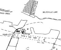
Runways
Runway Summary
| Runways: | 08/26 |
| Longest Runway: | 08/26 is 2018 ft (615 m) long |
| Runways with an Instrument Approach: |
14N Airport Runway Details
| Runway 08/26 | 2018 ft x 100 ft (615 m x 30 m) | |
| Runway Length Source: | FAA as of 05/23/2013 | |
| Surface: | Turf - Good condition - No special surface treatment | |
Runway Weight Bearing Capacity (in thousands of pounds) |
||
| Single Wheel Landing Gear: | 5.0 | |
Runway 08 |
Runway 26 |
|
Elevation: |
886.0 | 889.0 |
Latitude: |
40-50-35.2000N | 40-50-43.6700N |
Longitude: |
075-38-19.1600W | 075-37-55.3900W |
Glide Path Angle: |
0.0 degrees | 0.0 degrees |
Traffic Pattern: |
Left | Left |
Object at End: |
ROAD | FENCE |
Object Height: |
16 | 13 |
Distance from End: |
24 | 48 |
Object Centerline Offset: |
0 ft. left and right of centerline | 76 ft. right of centerline |
Threshold Elevation: |
886.0 | 887.0 |
Displaced Threshold: |
360 | 230 |
Threshold Latitude: |
40-50-36.7111N | 40-50-42.6900N |
Threshold Longitude: |
075-38-14.9197W | 075-37-58.0900W |
Services
Airframe Repair: |
Major |
Powerplant Repair: |
Major |
Bottled Oxygen: |
None |
Bulk Oxygen: |
None |
Fuel Available: |
100LL, Jet A |
Landing Fees: |
Yes |
Parking: |
Hangars and tiedowns available |
Maps & Diagrams
14N Sectional
Flight Planning
at skyvector.com
at skyvector.com