Location
Latitude: |
44-58-27.2000N (44.974222) |
Longitude: |
115-43-47.1000W (-115.72975) |
Elevation: |
3982.0 feet MSL (1214 m MSL) |
Magnetic Variation: |
13 E (as of April 2024 from WMM2020 model) |
Time Zone: |
UTC -7.0 (Standard Time) UTC -6.0 (Daylight Savings Time) |
From City: |
17 N.M. NE of Mc Call, Idaho |
Found On: |
Great Falls Chart |
FAA Region: |
ANM |
Contacts
Manager: |
Publicly owned: |
| KRASSEL DISTRICT RANGER 500 NORTH MISSION ST MC CALL, ID 83638 208-634-0600 |
US FOREST SERVICE 324 25TH ST OGDEN, UT 84401 801-625-5511 |
Operations
Airport Status: |
Operational |
Facility Use: |
Public |
Type: |
Airport |
Activation Date: |
07/1989 |
Control tower: |
No |
Attendance (Months/Days/Hours): |
Months/Days/Hours Unattended |
Boundary ARTCC: |
ZLC (Salt Lake City) |
Responsible ARTCC: |
ZLC (Salt Lake City) |
Segmented Circle Indicator: |
No |
Traffic Pattern Altitude (MSL): |
4982 feet (1519 m) |
NOTAMs Facility: |
BOI |
NOTAM-D Service: |
Yes |
Based Aircraft
Annual Operations (as of 06/30/2022)
| Total Operations: | 400 | |
| Air Taxi: | 200 | 50.0% |
| GA Itinerant: | 200 | 50.0% |
Communications
| CTAF: | 122.900 |
Fixed Based Operators (FBOs) & Fuel
(Click on a business for detail)
Please help us keep this information up to date. This is a FREE SERVICE just like everything else on Airport Guide! If you see that a business needs to be added, modified, or deleted please fill out our Update Form.
To add, modify, or delete a business click here.
Please help us keep this information up to date. This is a FREE SERVICE just like everything else on Airport Guide! If you see that a business needs to be added, modified, or deleted please fill out our Update Form.
Area Code: 208 |
| Business Name | Frequency | Phone | Fuel Grade |
|---|
Flight Service Stations
| Primary | Alternate | |
| FSS on Field: | ||
| FSS Name (ID): | Boise(BOI) | |
| Frequency: | ||
| Toll Free Phone: | 1-800-WX-BRIEF |
Instrument Procedures / Charts
Terminal Procedures are only available for airports in several countries with more being added all the time. If you are looking for a specific country's charts, please send an email to support(at)airportguide.com stating the country name. This will be used to prioritize the implementation.
Navigation Aids (Navaids) near 24K
| Dist (NM) | ID | Morse Code | Name | Type | Freq | True Hdg | Mag Hdg |
|---|---|---|---|---|---|---|---|
| 23.8 | DNJ | _ . . _ . . _ _ _ | Donnelly | VOR-DME | 116.20 | 238 | 225 |
| 69.9 | LKT | . _ . . _ . _ _ | Salmon | VOR-DME | 113.50 | 87 | 74 |
| 72.4 | IDQ | . . _ . . _ _ . _ | Cottonwood | DME | 115.65 | 334 | 321 |
| 79.2 | ONO | _ _ _ _ . _ _ _ | Ontario | NDB | 305 | 224 | 211 |
| 86.4 | BO | _ . . . _ _ _ | Ustik | NDB | 359 | 197 | 184 |
| 87.6 | BOI | _ . . . _ _ _ . . | Boise | VORTAC | 113.30 | 193 | 180 |
| 87.7 | BOI | _ . . . _ _ _ . . | Boise | VOT | 116.70 | 194 | 181 |
| 88.7 | BKE | _ . . . _ . _ . | Baker City | VOR-DME | 115.30 | 265 | 252 |
| 89.3 | MPA | _ _ . _ _ . . _ | Meridian | NDB | 238 | 203 | 190 |
| 97.0 | LGD | . _ . . _ _ . _ . . | La Grande | NDB | 296 | 283 | 270 |
| 97.0 | MQG | _ _ _ _ . _ _ _ . | Nez Perce | VOR-DME | 114.45 | 330 | 317 |
Nearby Airports with Fuel
Notices to Airmen (NOTAMS)
Remarks
| A110-1 | EXTSV HELICOPTER OPNS DURING SUMMER MONTHS. |
| A110-2 | +80 FT TO +120 FT TREES ADJ TO BOTH SIDES OF RWY. |
| A110-3 | CSDRBL RODENT ACT ON RWY. |
| A110-5 | MARKED PRIVATE USE HELIPAD ON ARPT. |
| A110-6 | FOR CD CTC SALT LAKE ARTCC AT 801-320-2568. |
| A30-17/35 | LND RWY 17; TKOF RWY 35 WHEN WND CONDS PMT. |
| A32-17/35 | MAY NOT BE MOWED TO FULL WIDTH. |
| A33-17/35 | RWY SFC ROUGH DUE TO RODENT HOLES/ACT. |
| A52-35 | +500 FT RDG 1800 FT ON CNTRLN. |
Runways
Runway Summary
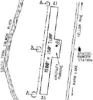
| Runways: | 17/35 |
| Longest Runway: | 17/35 is 1500 ft (457 m) long |
| Runways with an Instrument Approach: |
24K Airport Runway Details
| Runway 17/35 | 1500 ft x 150 ft (457 m x 46 m) | |
| Surface: | Turf - Fair condition - No special surface treatment | |
Runway 17 |
Runway 35 |
|
Elevation: |
3977.0 | 3980.0 |
Latitude: |
44-58-34.5600N | 44-58-19.8700N |
Longitude: |
115-43-45.7600W | 115-43-48.4300W |
|
Runway True Alignment: |
187 | 007 |
Glide Path Angle: |
0.0 degrees | 0.0 degrees |
Object at End: |
TREE | TREES |
Object Height: |
75 | 50 |
Distance from End: |
0 | 100 |
Object Centerline Offset: |
70 ft. left of centerline | 75 ft. left and right of centerline |
Services
Airframe Repair: |
Major |
Powerplant Repair: |
Major |
Bottled Oxygen: |
High Pressure |
Bulk Oxygen: |
None |
Fuel Available: |
100LL, Jet A, MOGAS |
Landing Fees: |
No |
Parking: |
Tiedowns available |
Maps & Diagrams
24K Sectional
Flight Planning
at skyvector.com
at skyvector.com