Location
Latitude: |
43-38-30.6560N (43.641849) |
Longitude: |
116-38-08.7510W (-116.635764) |
Elevation: |
2431.4 feet MSL (741 m MSL) |
Magnetic Variation: |
13 E (as of April 2024 from WMM2020 model) |
Time Zone: |
UTC -7.0 (Standard Time) UTC -6.0 (Daylight Savings Time) |
From City: |
03 N.M. SE of Caldwell, Idaho |
Found On: |
Salt Lake City Chart |
FAA Region: |
ANM |
Contacts
Manager: |
Publicly owned: |
| ROB OATES 4814 E. LINDEN STREET CALDWELL, ID 83605 208-459-9779 |
CITY OF CALDWELL PO BOX 1179 CALDWELL, ID 83606 208-455-3000 |
Operations
Airport Status: |
Operational |
Facility Use: |
Public |
Type: |
Airport |
Activation Date: |
09/1976 |
Control tower: |
No |
Attendance (Months/Days/Hours): |
Months/Days/Hours MAR-OCT/ALL/0800-1900 |
Boundary ARTCC: |
ZLC (Salt Lake City) |
Responsible ARTCC: |
ZLC (Salt Lake City) |
Lighting Schedule: |
SEE RMK |
Segmented Circle Indicator: |
Yes |
Traffic Pattern Altitude (MSL): |
3431 feet (1046 m) |
NOTAMs Facility: |
EUL |
NOTAM-D Service: |
Yes |
International Airport of Entry: |
No |
Customs Landing Rights: |
No |
Military Landing Rights: |
Yes |
Civil/Military Joint Use: |
No |
Based Aircraft
| Single Engine: | 464 |
| Multi Engine: | 26 |
| Jet Engine: | 6 |
| GA Helicopters: | 25 |
| Gliders: | 2 |
| Ultralights: | 1 |
Annual Operations (as of 12/15/2020)
| Total Operations: | 147325 | |
| Air Taxi: | 2000 | 1.4% |
| GA Local: | 110000 | 74.7% |
| GA Itinerant: | 35000 | 23.8% |
| Military Aircraft: | 325 | 0.2% |
Communications
| CTAF: | 123.000 |
| Unicom: | 123.000 |
| Approach: | BIG SKY 119.6 119.6 |
| Departure: | BIG SKY 119.6 119.6 |
| AWOS-3PT: | 135.075 (208-454-3953) |
Fixed Based Operators (FBOs) & Fuel
(Click on a business for detail)
Please help us keep this information up to date. This is a FREE SERVICE just like everything else on Airport Guide! If you see that a business needs to be added, modified, or deleted please fill out our Update Form.
To add, modify, or delete a business click here.
Please help us keep this information up to date. This is a FREE SERVICE just like everything else on Airport Guide! If you see that a business needs to be added, modified, or deleted please fill out our Update Form.
Area Code: 208 |
| Business Name | Frequency | Phone | Fuel Grade |
|---|---|---|---|
| Aviation Maintenance Center
Update FBO info |
455-5600 | ||
| Avjet Aviation
Update FBO info |
Unicom 122.8 | 459-0727 | 80, 100LL, Mogas, Jet A |
| Hinkle Aviation
Update FBO info |
455-0384 | ||
| Rapid Refueling
Update FBO info |
454-1669 | 100ll | |
| Shore & Shore Aviation
Update FBO info |
454-1669 | 100LL | |
| Sky Star Aircraft Corporation
Update FBO info |
454-2444 | ||
| Skydive Idaho
Update FBO info |
455-0000 | ||
| Warhawk Museum
Update FBO info |
454-2854 |
Flight Service Stations
| Primary | Alternate | |
| FSS on Field: | N | |
| FSS Name (ID): | Boise(BOI) | |
| Frequency: | ||
| Toll Free Phone: | 1-800-WX-BRIEF |
Instrument Procedures / Charts
FAA Terminal Procedures valid from 0901Z 03/21/24 to 0901Z 04/18/24.
There are various types of charts available for an airport. They are listed in the Page Type column. Here is a legend for those types:
APD - Airport Diagram
DP - Departure Procedure Charts
HOT - Hot Spots
IAP - Instrument Approach Procedure Charts
MIN - Minimums
STAR - Standard Terminal Arrival Charts
| Page Type | Page Name | Volume | Action Since Last Cycle |
|---|---|---|---|
| IAP | RNAV (GPS) RWY 12 | NW-1 | |
| IAP | RNAV (GPS) RWY 30 | NW-1 | |
| MIN | ALTERNATE MINIMUMS | NW-1 | |
| MIN | TAKEOFF MINIMUMS | NW-1 |
Terminal Procedures are only available for airports in several countries with more being added all the time. If you are looking for a specific country's charts, please send an email to support(at)airportguide.com stating the country name. This will be used to prioritize the implementation.
Navigation Aids (Navaids) near EUL
| Dist (NM) | ID | Morse Code | Name | Type | Freq | True Hdg | Mag Hdg |
|---|---|---|---|---|---|---|---|
| 4.8 | MPA | _ _ . _ _ . . _ | Meridian | NDB | 238 | 118 | 105 |
| 14.2 | BO | _ . . . _ _ _ | Ustik | NDB | 359 | 100 | 87 |
| 18.8 | BOI | _ . . . _ _ _ . . | Boise | VOT | 116.70 | 105 | 92 |
| 20.0 | BOI | _ . . . _ _ _ . . | Boise | VORTAC | 113.30 | 105 | 92 |
| 27.8 | ONO | _ _ _ _ . _ _ _ | Ontario | NDB | 305 | 324 | 311 |
| 49.0 | MUO | _ _ . . _ _ _ _ | Mountain Home | TACAN | 114.00 | 137 | 124 |
| 53.1 | STI | . . . _ . . | Sturgeon | NDB | 333 | 126 | 113 |
| 54.6 | LIA | . _ . . . . . _ | Liberator | VOR | 114.90 | 136 | 123 |
| 70.0 | DNJ | _ . . _ . . _ _ _ | Donnelly | VOR-DME | 116.20 | 15 | 2 |
| 83.0 | REO | . _ . . _ _ _ | Rome | VOR-DME | 112.50 | 220 | 207 |
| 87.8 | BKE | _ . . . _ . _ . | Baker City | VOR-DME | 115.30 | 325 | 312 |
| 96.1 | HDG | . . . . _ . . _ _ . | Steelhead | NDB | 211 | 116 | 103 |
Nearby Airports with Fuel
| Dist (NM) | Name (Airport IDs) | True Hdg | Mag Hdg | Fuel Grade |
|---|---|---|---|---|
| 6.1 | Nampa Municipal Airport (KMAN MAN) |
126 | 113 | 100LL, Jet A, MOGAS |
| 13.3 | Emmett Municipal Airport (S78) |
18 | 5 | 100LL |
| 18.5 | Boise Air Trml/Gowen Field Airport (BOI KBOI BOI) |
104 | 91 | 100LL, Jet A+ |
| 27.9 | Ontario Municipal Airport (ONO KONO ONO) |
324 | 311 | 100LL, Jet A |
| 29.5 | Payette Municipal Airport (S75) |
337 | 324 | 100LL, MOGAS |
| 36.6 | Weiser Municipal Airport (S87) |
337 | 324 | 100LL |
| 57.6 | Cascade Airport (U70) |
27 | 14 | 100LL, Jet A |
| 67.0 | Council Municipal Airport (U82) |
6 | 353 | 100LL |
| 78.3 | Mc Call Municipal Airport (MYL KMYL MYL) |
16 | 3 | 100LL, Jet A, Jet A-1+ |
| 81.0 | Stanley Airport (2U7) |
64 | 51 | 100LL |
| 87.7 | Baker City Municipal Airport (BKE KBKE BKE) |
325 | 311 | 100LL, Jet A |
| 92.5 | Gooding Municipal Airport (GNG KGNG GNG) |
117 | 105 | 100LL, Jet A |
Notices to Airmen (NOTAMS)
Remarks
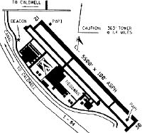
| A110-1 | +363 FT RADIO TWR LCTD 1.4 MILES NORTH OF ARPT. |
| A110-2 | FUEL AVBL 24 HRS BY CREDIT CARD. JET A FROM TRUCK MON-SAT 1500-2300Z++. CALL 208-453-8577 FOR JET A AND AFTER HOURS CALLOUT. |
| A110-3 | RWY 12 CALM WIND RWY. |
| A110-4 | PREFERRED PARKING FOR JET AND LARGE TURBOPROP ACFT AVBL ON TERMINAL APRON ON NORTH SIDE OF RWY. |
| A110-5 | COURTESY CAR AVBL FOR TRAN AIRCREWS. CALL 208-459-9779 TO REQ COURTESY CAR. |
| A110-6 | TRANSIENT RAMP PREFERRED FOR USE BY TRAINING HELICOPTERS FOR LAUNCH AND RECOVERY. |
| A110-7 | PREFERRED HELICOPTER PAT SW OF RWY. |
| A110-8 | FOR CD CTC BIG SKY APCH AT 208-364-5860/5861. |
| A74 | 208-459-2360. |
| A81-APT | ACTVT MIRL RY 12/30 - CTAF. PAPI RYS 12 & 30 OPER CONTINUOUSLY. |
Runways
Runway Summary
| Runways: | 12/30 |
| Longest Runway: | 12/30 is 5500 ft (1676 m) long |
| Runways with an Instrument Approach: |
EUL Airport Runway Details
| Runway 12/30 | 5500 ft x 100 ft (1676 m x 30 m) | |
| Runway Length Source: | 3RD PARTY SURVEY as of 06/10/2020 | |
| Surface: | Asphalt - Excellent condition - No special surface treatment | |
| Runway Edge Lights: | Medium Intensity | |
Runway Weight Bearing Capacity (in thousands of pounds) |
||
| Single Wheel Landing Gear: | 72.0 | |
| Dual Wheel Landing Gear: | 86.0 | |
Runway 12 |
Runway 30 |
|
Elevation: |
2425.9 | 2431.4 |
Latitude: |
43-38-49.8943N | 43-38-11.4150N |
Longitude: |
116-38-35.1424W | 116-37-42.3638W |
|
Runway True Alignment: |
135 | 315 |
Glide Path Angle: |
3.0 degrees | 3.0 degrees |
Traffic Pattern: |
Left | Right |
Runway Markings Type: |
Nonprecision Instrument | Nonprecision Instrument |
Runway Markings Condition: |
Good | Good |
Object at End: |
ROAD | |
Object Height: |
12 | |
Distance from End: |
330 | |
Object Centerline Offset: |
260 ft. left of centerline | |
Visual Glide Slope Indicators: |
4-Light PAPI On Left Side Of Runway | 4-Light PAPI On Left Side Of Runway |
Threshold Crossing Height: |
42 | 45 |
Services
Airframe Repair: |
Major |
Powerplant Repair: |
Major |
Bottled Oxygen: |
High Pressure / Low Pressure |
Bulk Oxygen: |
High Pressure / Low Pressure |
Fuel Available: |
100LL, Jet A |
Landing Fees: |
No |
Parking: |
Hangars and tiedowns available |
Maps & Diagrams
EUL Sectional
Flight Planning
at skyvector.com
at skyvector.com