Location
Latitude: |
44-45-01.2000N (44.750333) |
Longitude: |
116-26-42.2000W (-116.445056) |
Elevation: |
2966.0 feet MSL (904 m MSL) |
Magnetic Variation: |
13.2 E (as of April 2024 from WMM2020 model) |
Time Zone: |
UTC -7.0 (Standard Time) UTC -6.0 (Daylight Savings Time) |
From City: |
01 N.M. NW of Council, Idaho |
Found On: |
Great Falls Chart |
FAA Region: |
ANM |
Contacts
Manager: |
Publicly owned: |
| KATHRYN HUGHES P O BOX 606 COUNCIL, ID 83612 810-516-4028 |
CITY OF COUNCIL PO BOX 606 COUNCIL, ID 83612-0606 208-253-4201 |
Operations
Airport Status: |
Operational |
Facility Use: |
Public |
Type: |
Airport |
Activation Date: |
05/1947 |
Control tower: |
No |
Attendance (Months/Days/Hours): |
Months/Days/Hours Unattended |
Boundary ARTCC: |
ZLC (Salt Lake City) |
Responsible ARTCC: |
ZLC (Salt Lake City) |
Lighting Schedule: |
SEE RMK |
Segmented Circle Indicator: |
No |
Traffic Pattern Altitude (MSL): |
3966 feet (1209 m) |
NOTAMs Facility: |
BOI |
NOTAM-D Service: |
Yes |
International Airport of Entry: |
No |
Customs Landing Rights: |
No |
Military Landing Rights: |
Yes |
Civil/Military Joint Use: |
No |
Based Aircraft
| Single Engine: | 12 |
| GA Helicopters: | 1 |
Annual Operations (as of 03/30/2023)
| Total Operations: | 4000 | |
| GA Local: | 1500 | 37.5% |
| GA Itinerant: | 2500 | 62.5% |
Communications
| CTAF: | 122.800 |
| Unicom: | 122.800 |
- COMMUNICATIONS PRVDD BY BOISE RADIO ON FREQ 122.5 (CASCADE RCO).
Fixed Based Operators (FBOs) & Fuel
(Click on a business for detail)
Please help us keep this information up to date. This is a FREE SERVICE just like everything else on Airport Guide! If you see that a business needs to be added, modified, or deleted please fill out our Update Form.
To add, modify, or delete a business click here.
Please help us keep this information up to date. This is a FREE SERVICE just like everything else on Airport Guide! If you see that a business needs to be added, modified, or deleted please fill out our Update Form.
Area Code: 208 |
| Business Name | Frequency | Phone | Fuel Grade |
|---|---|---|---|
| Council Air Service
Update FBO info |
Unicom 122.8 | 253-4423, -6840 | 100LL |
Flight Service Stations
| Primary | Alternate | |
| FSS on Field: | N | |
| FSS Name (ID): | Boise(BOI) | |
| Frequency: | ||
| Toll Free Phone: | 1-800-WX-BRIEF |
Instrument Procedures / Charts
Terminal Procedures are only available for airports in several countries with more being added all the time. If you are looking for a specific country's charts, please send an email to support(at)airportguide.com stating the country name. This will be used to prioritize the implementation.
Navigation Aids (Navaids) near U82
| Dist (NM) | ID | Morse Code | Name | Type | Freq | True Hdg | Mag Hdg |
|---|---|---|---|---|---|---|---|
| 10.2 | DNJ | _ . . _ . . _ _ _ | Donnelly | VOR-DME | 116.20 | 84 | 71 |
| 50.1 | ONO | _ _ _ _ . _ _ _ | Ontario | NDB | 305 | 209 | 196 |
| 58.3 | BKE | _ . . . _ . _ . | Baker City | VOR-DME | 115.30 | 275 | 262 |
| 68.9 | MPA | _ _ . _ _ . . _ | Meridian | NDB | 238 | 183 | 170 |
| 69.4 | BO | _ . . . _ _ _ | Ustik | NDB | 359 | 175 | 162 |
| 72.3 | BOI | _ . . . _ _ _ . . | Boise | VOT | 116.70 | 172 | 159 |
| 72.7 | BOI | _ . . . _ _ _ . . | Boise | VORTAC | 113.30 | 171 | 158 |
| 73.5 | LGD | . _ . . _ _ . _ . . | La Grande | NDB | 296 | 299 | 286 |
| 78.9 | IDQ | . . _ . . _ _ . _ | Cottonwood | DME | 115.65 | 359 | 346 |
| 99.5 | MQG | _ _ _ _ . _ _ _ . | Nez Perce | VOR-DME | 114.45 | 349 | 336 |
Nearby Airports with Fuel
Notices to Airmen (NOTAMS)
Remarks
| A110-1 | ARPT SURROUNDED BY MTNS ALL QUADRANTS. |
| A110-2 | FOR CD CTC SALT LAKE ARTCC AT 801-320-2568. |
| A81-APT | ACTVT MIRL RY 17/35 - CTAF. |
| E111 | ESTABD PRIOR TO 15 MAY 1959. |
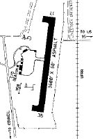
Runways
Runway Summary
| Runways: | 17/35 |
| Longest Runway: | 17/35 is 3600 ft (1097 m) long |
| Runways with an Instrument Approach: |
U82 Airport Runway Details
| Runway 17/35 | 3600 ft x 60 ft (1097 m x 18 m) | |
| Surface: | Asphalt - Fair condition - No special surface treatment | |
| Runway Edge Lights: | Medium Intensity | |
Runway Weight Bearing Capacity (in thousands of pounds) |
||
| Single Wheel Landing Gear: | 12.5 | |
Runway 17 |
Runway 35 |
|
Elevation: |
2966.0 | 2932.0 |
Latitude: |
44-45-18.7700N | 44-44-43.7100N |
Longitude: |
116-26-38.0500W | 116-26-46.3600W |
|
Runway True Alignment: |
190 | 010 |
Glide Path Angle: |
0.0 degrees | 0.0 degrees |
Traffic Pattern: |
Left | Left |
Runway Markings Type: |
Basic | Basic |
Runway Markings Condition: |
Good | Good |
Object at End: |
BRUSH | |
Object Height: |
10 | |
Distance from End: |
350 | |
Object Centerline Offset: |
100 ft. left of centerline |
Services
Airframe Repair: |
Major |
Powerplant Repair: |
Major |
Bottled Oxygen: |
None |
Fuel Available: |
100, Jet A |
Landing Fees: |
No |
Parking: |
Tiedowns available |
Maps & Diagrams
U82 Sectional
Flight Planning
at skyvector.com
at skyvector.com