Location
Latitude: |
43-33-51.7000N (43.564361) |
Longitude: |
116-13-22.3000W (-116.222861) |
Elevation: |
2871.7 feet MSL (875 m MSL) |
Magnetic Variation: |
12.9 E (as of April 2024 from WMM2020 model) |
Time Zone: |
UTC -7.0 (Standard Time) UTC -6.0 (Daylight Savings Time) |
From City: |
03 N.M. S of Boise, Idaho |
Found On: |
Salt Lake City Chart |
FAA Region: |
ANM |
Contacts
Manager: |
Publicly owned: |
| REBECCA HUPP 3201 AIRPORT WAY SUITE 1000 BOISE, ID 83705 (208) 972-8420 |
CITY OF BOISE PO BOX 500 BOISE, ID 83701 208-383-3110 |
Operations
Airport Status: |
Operational |
Facility Use: |
Public |
Type: |
Airport |
Activation Date: |
04/1940 |
Control tower: |
Yes |
Attendance (Months/Days/Hours): |
Months/Days/Hours ALL/ALL/ALL |
Boundary ARTCC: |
ZLC (Salt Lake City) |
Responsible ARTCC: |
ZLC (Salt Lake City) |
Lighting Schedule: |
SS-SR |
Segmented Circle Indicator: |
No |
Traffic Pattern Altitude (MSL): |
3872 feet (1180 m) |
NOTAMs Facility: |
BOI |
NOTAM-D Service: |
Yes |
International Airport of Entry: |
No |
Customs Landing Rights: |
Yes |
Military Landing Rights: |
Yes |
Civil/Military Joint Use: |
No |
Aircraft Rescue and Firefighting: |
Class I ARFF Index: C Air Carrier Service: Scheduled Certification Date: 05/1973 |
Based Aircraft
| Single Engine: | 147 |
| Multi Engine: | 22 |
| Jet Engine: | 37 |
| GA Helicopters: | 17 |
| Military Aircraft: | 50 |
Annual Operations (as of 05/31/2023)
| Total Operations: | 139983 | |
| Commercial: | 55001 | 39.3% |
| Air Taxi: | 12459 | 8.9% |
| GA Local: | 17382 | 12.4% |
| GA Itinerant: | 47752 | 34.1% |
| Military Aircraft: | 7389 | 5.3% |
Communications
| Unicom: | 122.950 |
| Tower: | BOISE 118.1 257.8 119.0 Hrs: 24 |
| Clearance Del.: | 125.9 323.2 |
| Ground: | 121.7 348.6 |
| Approach: | BIG SKY 119.6 ;MORE THAN 15 NM FM BOI 126.9 ;WITHIN 15 NM OF BOI 269.4 ;SOUTH 351.85 ;NORTH Hrs: 24 |
| Departure: | BIG SKY 119.6 ;MORE THAN 15 NM FM BOI 126.9 ;WITHIN 15 NM OF BOI 269.4 ;SOUTH 351.85 ;NORTH Hrs: 24 |
| ATIS: | 123.9 290.4 Hrs: 24 |
| ASOS: | (208-388-4640) |
| CLASS C: | 351.85 ;NORTH |
| CLASS C: | 119.6 ;SOUTH |
| CLASS C: | 269.4 ;SOUTH |
| EMERG: | 121.5 |
| ANG OPS: | 298.7 |
| CLASS C: | 126.9 ;NORTH |
- OR INBOUND FM HORSESHOE BEND/ALDAPE PEAK.
- ARNG OPS DSN 422-3976. ALL ARMY R/W ACFT CTC DSN 422-3976.
Fixed Based Operators (FBOs) & Fuel
(Click on a business for detail)
Please help us keep this information up to date. This is a FREE SERVICE just like everything else on Airport Guide! If you see that a business needs to be added, modified, or deleted please fill out our Update Form.
To add, modify, or delete a business click here.
Please help us keep this information up to date. This is a FREE SERVICE just like everything else on Airport Guide! If you see that a business needs to be added, modified, or deleted please fill out our Update Form.
Area Code: 208 |
| Business Name | Frequency | Phone | Fuel Grade |
|---|---|---|---|
| Aviation Air Center/Idaho Helicopters
Update FBO info |
Unicom 153.035 | 344-4361 | 100LL, Jet A |
| Boise Air Service
Update FBO info |
Unicom 122.95 | 383-3300 | 100LL, Jet A |
| Boise Executive Terminal
Update FBO info |
Unicom 122.95 | 383-3191 | 100LL, Jet A |
| Boise Pilot Shop
Update FBO info |
336-3161 | ||
| Conyan Aviation
Update FBO info |
342-1042 | 100LL, Jet A | |
| Ponderosa Aero Club
Update FBO info |
344-5401 | ||
| Precision Propeller
Update FBO info |
344-5161 | ||
| SP Aircraft
Update FBO info |
383-3323 | ||
| Turbo Air
Update FBO info |
343-3300 | ||
| Western Aircraft, Inc.
Update FBO info |
Arinc 129.8 | 800-333-3442, 338-1800 | 100LL, Jet A |
Flight Service Stations
| Primary | Alternate | |
| FSS on Field: | N | |
| FSS Name (ID): | Boise(BOI) | |
| Frequency: | ||
| Toll Free Phone: | 1-800-WX-BRIEF |
Instrument Procedures / Charts
FAA Terminal Procedures valid from 0901Z 03/21/24 to 0901Z 04/18/24.
There are various types of charts available for an airport. They are listed in the Page Type column. Here is a legend for those types:
APD - Airport Diagram
DP - Departure Procedure Charts
HOT - Hot Spots
IAP - Instrument Approach Procedure Charts
MIN - Minimums
STAR - Standard Terminal Arrival Charts
| Page Type | Page Name | Volume | Action Since Last Cycle |
|---|---|---|---|
| APD | AIRPORT DIAGRAM | NW-1 | |
| DP | BOISE THREE | NW-1 | |
| HOT | HOT SPOT | NW-1 | |
| IAP | HI-ILS Z OR LOC Z RWY 10R | NW-1 | |
| IAP | HI-VOR OR TACAN RWY 10R | NW-1 | |
| IAP | HI-VOR Z OR TACAN Z RWY 28L | NW-1 | |
| IAP | ILS OR LOC RWY 28R | NW-1 | |
| IAP | ILS Y OR LOC Y RWY 10R | NW-1 | |
| IAP | ILS Y RWY 10R (CAT II - III) | NW-1 | |
| IAP | ILS Y RWY 10R (SA CAT I) | NW-1 | |
| IAP | RNAV (GPS) Y RWY 10L | NW-1 | |
| IAP | RNAV (GPS) Y RWY 10R | NW-1 | |
| IAP | RNAV (GPS) Y RWY 28L | NW-1 | |
| IAP | RNAV (GPS) Y RWY 28R | NW-1 | |
| IAP | RNAV (RNP) X RWY 28L | NW-1 | |
| IAP | RNAV (RNP) X RWY 28R | NW-1 | |
| IAP | RNAV (RNP) Z RWY 10L | NW-1 | |
| IAP | RNAV (RNP) Z RWY 10R | NW-1 | |
| IAP | RNAV (RNP) Z RWY 28L | NW-1 | |
| IAP | RNAV (RNP) Z RWY 28R | NW-1 | |
| IAP | VOR OR TACAN RWY 10L | NW-1 | |
| IAP | VOR Y OR TACAN Y RWY 28L | NW-1 | |
| MIN | ALTERNATE MINIMUMS | NW-1 | |
| MIN | DIVERSE VECTOR AREA | NW-1 | |
| MIN | TAKEOFF MINIMUMS | NW-1 | |
| ODP | GOWEN FOUR (OBSTACLE) | NW-1 | |
| STAR | BEWTE FOUR (RNAV) | NW-1 | |
| STAR | KOURT FOUR (RNAV) | NW-1 | |
| STAR | KYAAN FOUR (RNAV) | NW-1 | |
| STAR | SADYL FOUR (RNAV) | NW-1 | |
| STAR | SPUUD FOUR (RNAV) | NW-1 |
Terminal Procedures are only available for airports in several countries with more being added all the time. If you are looking for a specific country's charts, please send an email to support(at)airportguide.com stating the country name. This will be used to prioritize the implementation.
Navigation Aids (Navaids) near BOI
| Dist (NM) | ID | Morse Code | Name | Type | Freq | True Hdg | Mag Hdg |
|---|---|---|---|---|---|---|---|
| 0.5 | BOI | _ . . . _ _ _ . . | Boise | VOT | 116.70 | 164 | 151 |
| 1.5 | BOI | _ . . . _ _ _ . . | Boise | VORTAC | 113.30 | 117 | 104 |
| 4.5 | BO | _ . . . _ _ _ | Ustik | NDB | 359 | 295 | 282 |
| 13.9 | MPA | _ _ . _ _ . . _ | Meridian | NDB | 238 | 279 | 266 |
| 34.9 | MUO | _ _ . . _ _ _ _ | Mountain Home | TACAN | 114.00 | 154 | 141 |
| 36.6 | STI | . . . _ . . | Sturgeon | NDB | 333 | 137 | 124 |
| 40.0 | LIA | . _ . . . . . _ | Liberator | VOR | 114.90 | 150 | 137 |
| 43.6 | ONO | _ _ _ _ . _ _ _ | Ontario | NDB | 305 | 309 | 296 |
| 72.2 | DNJ | _ . . _ . . _ _ _ | Donnelly | VOR-DME | 116.20 | 0 | 347 |
| 78.1 | HDG | . . . . _ . . _ _ . | Steelhead | NDB | 211 | 119 | 106 |
| 87.4 | HLE | . . . . . _ . . . | Hailey | NDB-DME | 220 | 98 | 85 |
| 92.8 | REO | . _ . . _ _ _ | Rome | VOR-DME | 112.50 | 231 | 218 |
Nearby Airports with Fuel
| Dist (NM) | Name (Airport IDs) | True Hdg | Mag Hdg | Fuel Grade |
|---|---|---|---|---|
| 13.1 | Nampa Municipal Airport (KMAN MAN) |
274 | 261 | 100LL, Jet A, MOGAS |
| 18.5 | Caldwell Exec Airport (EUL KEUL EUL) |
284 | 271 | 100LL, Jet A, Jet A+ |
| 22.1 | Emmett Municipal Airport (S78) |
321 | 308 | 100LL |
| 43.3 | Payette Municipal Airport (S75) |
317 | 304 | 100LL, MOGAS |
| 43.8 | Ontario Municipal Airport (ONO KONO ONO) |
308 | 295 | 100LL, Jet A |
| 49.9 | Weiser Municipal Airport (S87) |
320 | 307 | 100LL |
| 56.4 | Cascade Airport (U70) |
9 | 356 | 100LL, Jet A |
| 67.8 | Stanley Airport (2U7) |
54 | 41 | 100LL |
| 71.8 | Council Municipal Airport (U82) |
352 | 339 | 100LL |
| 74.6 | Gooding Municipal Airport (GNG KGNG GNG) |
120 | 108 | 100LL, Jet A |
| 79.6 | Mc Call Municipal Airport (MYL KMYL MYL) |
3 | 350 | 100LL, Jet A, Jet A-1+ |
| 83.9 | Friedman Meml Airport (SUN KSUN SUN) |
91 | 79 | 100LL, Jet A-1+ |
| 85.1 | Buhl Municipal Airport (U03) |
132 | 120 | 100LL, MOGAS |
| 92.2 | Jerome County Airport (KJER JER) |
122 | 110 | 100LL, Jet A, Jet A+ |
Notices to Airmen (NOTAMS)
Remarks
| A110-1 | EXTSV HEL OPNS SFC TO 3500' WITHIN 1 NM EAST & WEST & 5 NM S OF RWY 10R/28L. |
| A110-10 | CSTMS/AG/IMG: 1400-0130Z++ MON-FRI, PHONE 24 HRS PRIOR TO ARRIVAL C208-334-9062. |
| A110-11 | ANG: OPR 1400-2330Z++ CLSD WKND, HOL AND DOWN MON. TRAN SVC UNAVBL OUTSIDE OF ANG OPR HR. FOR FBO SVC AND PRK CTC FBO. TRAN SVC AND GND EQPT VERY LTD OTHER THAN A10 ACFT. TRAN MUST BE ABLE TO FUEL/SVC OWN ACFT. |
| A110-13 | MISC: BASE SECURITY DSN 422-5366 (H24)COMD POST BUS HR ONLY DSN: 422-5333, BASE OPS BUS HR ONLY DSN 422-5345. |
| A110-14 | - ARNG DSN 422-3976 C208-272-3976, 1330-0600Z++ MON-FRI. ALL ARNG RAMP ACFT OPS USE ADVISORY FREQ 266.2. C-12 OPS DSN 422-3588. |
| A110-15 | ANG: AFLD MGR DOES NOT ISSUE OR STORE COMSEC FOR TRANS CREWS. |
| A110-16 | CAUTION: ALL MIL ACFT OPR: BASH PHASE II PERIOD (1 OCT-31 MAR), BIRD WATCH COND SEVERE (TKOF, LDG AND LOW APCH PROH UNLESS GREATER EMERG AND/OR IMMED OPR NEC EXISTS, LCL AND TACTICAL TRNG PROH), MODERATE (MULTIPLE APCH PROH, DEP AND FULL STOP ALLOWED IF RTE AVOIDS BIRD ACT.) |
| A110-2 | SCTY RQRS PPR WITH FBO DUE TO LOCKED GATES & FENCING BTN HRS 2200-0700 FOR INGRESS/EGRESS TO ARPT. |
| A110-20 | THE ARPT REQ FLT CREWS PRKG ON THE COML RAMP CTC GND CTL ON 121.7 MHZ PRIOR TO PUSHBACK. |
| A110-21 | ANG: NTSD MRK ON WEST PRK RAMP FOR WHITE WINGTIP CLNC LINE BEHIND PRK SPOTS, AND WHITE PRK SPOT DESIGNATED NR. PERM WAIVER FOR GUARD RAILS THAT ENCROACH ON WINGTIP CLNC LINE, FADED AND OBSCR NTSD MRK ON EAST PRK RAMP. |
| A110-22 | TWY A5 CLSD TO ACFT WITH WINGSPAN OVR 55 FT, EXC WITH 24 HR PPR (208 972 8420). |
| A110-23 | ALL TWYS CLSD TO ACFT WITH WINGSPAN OVER 170 FT EXCEPT 1 HR PPR 208-972-8420. TWY J NORTH OF TWY F CLSD TO ACFT WITH WINGSPAN OVER 94 FT WHEN WEST ARM/DEARM PAD IN USE. TWY B CLSD BTN TWY F AND TWY C TO ACFT WITH WINGSPAN OVER 147 FT 1 IN EXCEPT 1 HR PPR 208-972-8420. TWY B CLSD BTN TWY C AND TWY B1 TO ACFT WITH WINGSPAN OVER 118 FT WHEN WHEN EAST ARM/DEARM PAD IN USE. TWY S AND TXL S CLSD TO ACFT OVER 170 FT WINGSPAN BTN TWY B AND SOUTHEAST CARGO. TXL S CLSD TO ACFT OVER 100 FT WINGSPAN EAST OF SOUTHEAST CARGO. TXL A5 CLSD TO ACFT WITH WINGSPAN OVER 55 FT. |
| A110-3 | (A89) LOCAL CALL TO FSS 343-2525. |
| A110-4 | (E94) WSFO |
| A110-5 | MODERATE MIGRATORY BIRD ACTIVITY WITHIN 5 NM OF THE AIRPORT OCTOBER THROUGH MARCH. |
| A110-6 | AERODROME OFFL BUS ONLY FOR ALL MIL ACFT. MANDATORY PPR RQR FOR ALL MIL ACFT ARR AT KBOI-REGARDLESS OF WHERE ACFT IS PRKG-PRIOR TO ARR, NO LATER THAN 72 HR IF PRK ON ANG RAMP AT HTTP://WWW.124THFIGHTERWING.ANG.AF.MIL/. STRICTLY ENFORCED. PPR VALID +/- 30 MIN. TRAN ACFT RSTD TO STR-IN FULL STOP ONLY. IN EVENT OF GO-AROUND OR MISSED-APCH EXP RT TFC.' |
| A110-7 | PORTIONS OF TWY K & THE SOUTHWEST RAMP NOT VSBL TO ATCT. |
| E80 | FLIGHT NOTIFICATION SERVICE (ADCUS) AVBL MON-FRI 0800-1700; WEEKENDS IF NOTIFIED BY 1700 THURS. |
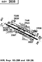
Runways
Runway Summary
| Runways: | 10L/28R 10R/28L |
| Longest Runway: | 10L/28R is 10000 ft (3048 m) long |
| Runways with an Instrument Approach: | 28R, 10R, 28L |
BOI Airport Runway Details
| Runway 10L/28R | 10000 ft x 150 ft (3048 m x 46 m) | |
| Runway Length Source: | 3RD PARTY SURVEY as of 04/05/2017 | |
| Surface: | Asphalt - Good condition - Saw-cut or plastic grooved | |
| Runway Pavement Class: | 105/F/C/W/T | |
| Runway Edge Lights: | High Intensity | |
Runway Weight Bearing Capacity (in thousands of pounds) |
||
| Single Wheel Landing Gear: | 100.0 | |
| Dual Wheel Landing Gear: | 210.0 | |
| Dual Tandem Wheel Landing Gear: | 446.0 | |
| Dual Dual Tandem Wheel Landing Gear: | 947.0 | |
Runway 10L |
Runway 28R |
|
Elevation: |
2830.6 | 2871.7 |
Latitude: |
43-34-12.7569N | 43-33-30.7950N |
Longitude: |
116-14-12.8818W | 116-12-09.9544W |
|
Runway True Alignment: |
115 | 295 |
ILS Type: |
ILS/DME | |
Glide Path Angle: |
3.0 degrees | 3.0 degrees |
Traffic Pattern: |
Left | Right |
Runway Markings Type: |
Nonprecision Instrument | Precision Instrument |
Runway Markings Condition: |
Good | Good |
Object at End: |
ANT | |
Object Height: |
16 | |
Object Marked/Lighted?: |
Lighted | |
Distance from End: |
600 | 52 |
Object Centerline Offset: |
300 ft. right of centerline | |
Visual Glide Slope Indicators: |
4-Light PAPI On Right Side Of Runway | 4-Light PAPI On Left Side Of Runway |
REIL: |
Yes | |
Threshold Crossing Height: |
53 | 70 |
Declared Distances |
||
Take Off Run Avbl. (TORA): |
10000 | 10000 |
Take Off Distance Avbl. (TODA): |
10000 | 10000 |
Actual Stop Dist. Avbl. (ASDA): |
10000 | 10000 |
Landing Dist. Avbl. (LDA): |
10000 | 10000 |
| Runway 10R/28L | 9763 ft x 150 ft (2976 m x 46 m) | |
| Runway Length Source: | 3RD PARTY SURVEY as of 04/05/2017 | |
| Surface: | Asphalt - Good condition - Saw-cut or plastic grooved | |
| Runway Pavement Class: | 76 /F/B/W/T | |
| Runway Edge Lights: | High Intensity | |
Runway Weight Bearing Capacity (in thousands of pounds) |
||
| Single Wheel Landing Gear: | 100.0 | |
| Dual Wheel Landing Gear: | 210.0 | |
| Dual Tandem Wheel Landing Gear: | 430.0 | |
| Dual Dual Tandem Wheel Landing Gear: | 994.0 | |
Runway 10R |
Runway 28L |
|
Elevation: |
2824.2 | 2858.3 |
Latitude: |
43-34-12.1246N | 43-33-31.1626N |
Longitude: |
116-14-33.4184W | 116-12-33.3940W |
|
Runway True Alignment: |
115 | 295 |
ILS Type: |
ILS/DME | MLS |
Glide Path Angle: |
3.0 degrees | 3.0 degrees |
Traffic Pattern: |
Right | Left |
Runway Markings Type: |
Precision Instrument | Precision Instrument |
Runway Markings Condition: |
Good | Good |
Arresting Device: |
BAK-14 | BAK-14 |
Object Centerline Offset: |
300 ft. right of centerline | |
Visual Glide Slope Indicators: |
4-Box VASI On Left Side Of Runway | 4-Box VASI On Left Side Of Runway |
Runway Visual Range (RVR): |
Touchdown, Midfield, Rollout | Touchdown, Midfield, Rollout |
Approach Light System: |
Standard 2,400 Foot High Intensity Approach Lighting System With Sequenced Flashers, Cat. II or III Config. | 1,400 Foot Medium Intensity Approach Lighting System With Runway Alignment Indicator Lights |
Touchdown Lights: |
Yes | Yes |
Centerline Lights: |
Yes | Yes |
Threshold Crossing Height: |
64 | 50 |
Declared Distances |
||
Take Off Run Avbl. (TORA): |
9763 | 9763 |
Take Off Distance Avbl. (TODA): |
9763 | 9763 |
Actual Stop Dist. Avbl. (ASDA): |
9763 | 9763 |
Landing Dist. Avbl. (LDA): |
9763 | 9763 |
Services
Airframe Repair: |
Major |
Powerplant Repair: |
Major |
Bottled Oxygen: |
None |
Bulk Oxygen: |
None |
Fuel Available: |
100LL, Jet A, Jet A+ |
Landing Fees: |
No |
Parking: |
Buoys, hangars, and tiedowns available |
Maps & Diagrams
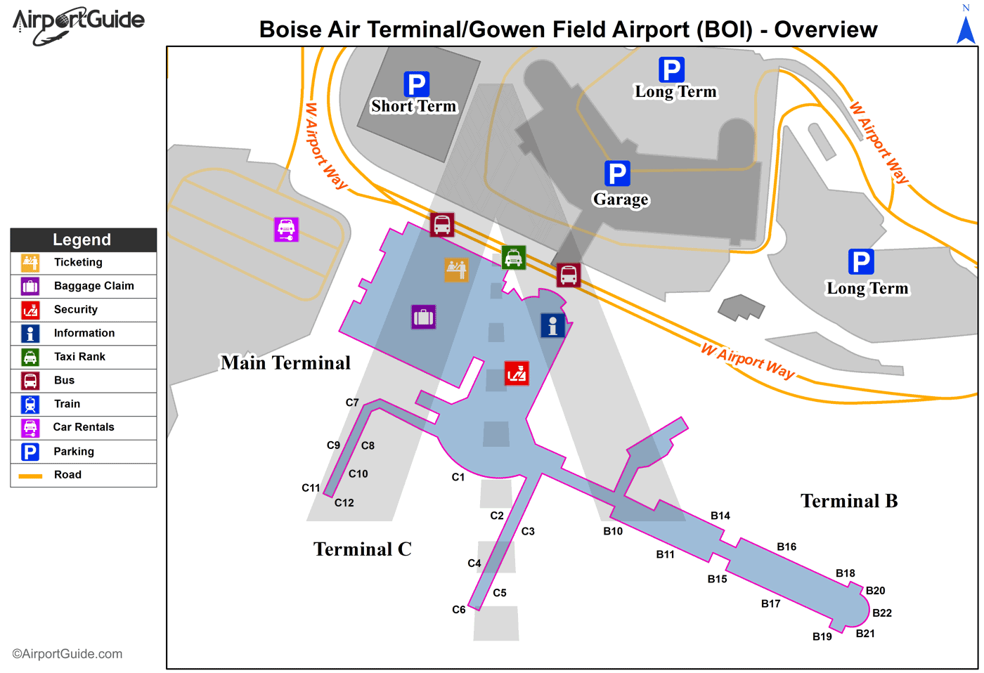
BOI Sectional
Flight Planning
at skyvector.com
at skyvector.com