Location
Latitude: |
44-01-09.7000N (44.019361) |
Longitude: |
117-00-46.9000W (-117.013028) |
Elevation: |
2193.3 feet MSL (669 m MSL) |
Magnetic Variation: |
13.2 E (as of April 2024 from WMM2020 model) |
Time Zone: |
UTC -7.0 (Standard Time) UTC -6.0 (Daylight Savings Time) |
From City: |
03 N.M. W of Ontario, Oregon |
Found On: |
Klamath Falls Chart |
FAA Region: |
ANM |
Contacts
Manager: |
Publicly owned: |
| ANDY WOOD 581 SW 33RD ST. ONTARIO, OR 97914 541-709-7651 |
CITY OF ONTARIO 444 SW 4TH ST ONTARIO, OR 97914 541-889-7684 |
Operations
Airport Status: |
Operational |
Facility Use: |
Public |
Type: |
Airport |
Activation Date: |
05/1947 |
Control tower: |
No |
Attendance (Months/Days/Hours): |
Months/Days/Hours ALL/ALL/0800-1700 |
Boundary ARTCC: |
ZLC (Salt Lake City) |
Responsible ARTCC: |
ZLC (Salt Lake City) |
Lighting Schedule: |
SEE RMK |
Segmented Circle Indicator: |
No |
Traffic Pattern Altitude (MSL): |
3193 feet (973 m) |
NOTAMs Facility: |
ONO |
NOTAM-D Service: |
Yes |
International Airport of Entry: |
No |
Customs Landing Rights: |
No |
Military Landing Rights: |
Yes |
Civil/Military Joint Use: |
No |
Based Aircraft
| Single Engine: | 88 |
| Multi Engine: | 2 |
| GA Helicopters: | 3 |
| Gliders: | 3 |
Annual Operations (as of 09/18/2019)
| Total Operations: | 12930 | |
| GA Local: | 4850 | 37.5% |
| GA Itinerant: | 8080 | 62.5% |
Communications
| CTAF: | 122.800 |
| Unicom: | 122.800 |
| ASOS: | 135.275 (541-889-7388) |
- APCH/DEP CTL SVC PRVDD BY SALT LAKE ARTCC (ZLC) ON FREQS 128.05/306.95 (BAKER RCAG).
- COMMUNICATIONS PRVDD BY MC MINNVILLE FSS ON FREQ 122.3 (ONTARIO RCO).
Fixed Based Operators (FBOs) & Fuel
(Click on a business for detail)
Please help us keep this information up to date. This is a FREE SERVICE just like everything else on Airport Guide! If you see that a business needs to be added, modified, or deleted please fill out our Update Form.
To add, modify, or delete a business click here.
Please help us keep this information up to date. This is a FREE SERVICE just like everything else on Airport Guide! If you see that a business needs to be added, modified, or deleted please fill out our Update Form.
Area Code: 541 |
| Business Name | Frequency | Phone | Fuel Grade |
|---|---|---|---|
| Flying W Aviation
Update FBO info |
889-0453 | ||
| Ontario Aviation, Inc.
Update FBO info |
889-9197 | 100ll, Jet A |
Flight Service Stations
| Primary | Alternate | |
| FSS on Field: | N | |
| FSS Name (ID): | Mc Minnville(MMV) | |
| Frequency: | ||
| Toll Free Phone: | 1-800-WX-BRIEF |
Instrument Procedures / Charts
FAA Terminal Procedures valid from 0901Z 03/21/24 to 0901Z 04/18/24.
There are various types of charts available for an airport. They are listed in the Page Type column. Here is a legend for those types:
APD - Airport Diagram
DP - Departure Procedure Charts
HOT - Hot Spots
IAP - Instrument Approach Procedure Charts
MIN - Minimums
STAR - Standard Terminal Arrival Charts
| Page Type | Page Name | Volume | Action Since Last Cycle |
|---|---|---|---|
| IAP | RNAV (GPS) RWY 15 | NW-1 | |
| IAP | RNAV (GPS) RWY 33 | NW-1 | |
| MIN | ALTERNATE MINIMUMS | NW-1 | |
| MIN | TAKEOFF MINIMUMS | NW-1 |
Terminal Procedures are only available for airports in several countries with more being added all the time. If you are looking for a specific country's charts, please send an email to support(at)airportguide.com stating the country name. This will be used to prioritize the implementation.
Navigation Aids (Navaids) near ONO
| Dist (NM) | ID | Morse Code | Name | Type | Freq | True Hdg | Mag Hdg |
|---|---|---|---|---|---|---|---|
| 0.2 | ONO | _ _ _ _ . _ _ _ | Ontario | NDB | 305 | 84 | 71 |
| 32.3 | MPA | _ _ . _ _ . . _ | Meridian | NDB | 238 | 140 | 127 |
| 39.4 | BO | _ . . . _ _ _ | Ustik | NDB | 359 | 129 | 116 |
| 44.2 | BOI | _ . . . _ _ _ . . | Boise | VOT | 116.70 | 128 | 115 |
| 45.3 | BOI | _ . . . _ _ _ . . | Boise | VORTAC | 113.30 | 127 | 114 |
| 56.6 | DNJ | _ . . _ . . _ _ _ | Donnelly | VOR-DME | 116.20 | 37 | 24 |
| 59.9 | BKE | _ . . . _ . _ . | Baker City | VOR-DME | 115.30 | 325 | 312 |
| 76.8 | MUO | _ _ . . _ _ _ _ | Mountain Home | TACAN | 114.00 | 139 | 126 |
| 80.1 | STI | . . . _ . . | Sturgeon | NDB | 333 | 132 | 119 |
| 82.3 | LIA | . _ . . . . . _ | Liberator | VOR | 114.90 | 138 | 125 |
| 87.9 | ILR | . . . _ . . . _ . | Wildhorse | VOR-DME | 114.55 | 253 | 240 |
| 89.1 | LGD | . _ . . _ _ . _ . . | La Grande | NDB | 296 | 333 | 320 |
| 93.5 | REO | . _ . . _ _ _ | Rome | VOR-DME | 112.50 | 203 | 190 |
Nearby Airports with Fuel
| Dist (NM) | Name (Airport IDs) | True Hdg | Mag Hdg | Fuel Grade |
|---|---|---|---|---|
| 6.5 | Payette Municipal Airport (S75) |
46 | 33 | 100LL, MOGAS |
| 11.3 | Weiser Municipal Airport (S87) |
11 | 358 | 100LL |
| 22.8 | Emmett Municipal Airport (S78) |
115 | 102 | 100LL |
| 27.9 | Caldwell Exec Airport (EUL KEUL EUL) |
144 | 131 | 100LL, Jet A, Jet A+ |
| 33.8 | Nampa Municipal Airport (KMAN MAN) |
140 | 127 | 100LL, Jet A, MOGAS |
| 43.8 | Boise Air Trml/Gowen Field Airport (BOI KBOI BOI) |
128 | 115 | 100LL, Jet A+ |
| 50.2 | Council Municipal Airport (U82) |
28 | 15 | 100LL |
| 51.4 | Cascade Airport (U70) |
56 | 43 | 100LL, Jet A |
| 59.8 | Baker City Municipal Airport (BKE KBKE BKE) |
325 | 311 | 100LL, Jet A |
| 65.1 | Mc Call Municipal Airport (MYL KMYL MYL) |
36 | 23 | 100LL, Jet A, Jet A-1+ |
| 85.0 | Enterprise Municipal Airport (8S4) |
352 | 339 | 100LL |
| 87.2 | Grant County Regional/Ogilvie Field Airport (JDA KGCD GCD) |
285 | 271 | 100LL, Jet A |
| 87.2 | La Grande/Union County Airport (LGD KLGD LGD) |
331 | 317 | 100LL, Jet A |
| 87.9 | Burns Municipal Airport (BNO KBNO BNO) |
253 | 239 | 100LL, Jet A |
| 90.3 | Stanley Airport (2U7) |
82 | 69 | 100LL |
Notices to Airmen (NOTAMS)
Remarks
| A110-1 | RWY 15 DESIGNATED AS CALM WINDS RWY |
| A110-2 | GLDR OPS SFC-5000 FT FRI-SAT 11AM-5PM (WX PMTG) MAR-OCT. NOTAMS WILL BE ISSUED WHEN ACTV. GLDRS WILL OPER ON WESTSIDE OF AP & WILL UTILIZE GRASS RWY ADJ TO RWY 15/33 ON WESTSIDE. CALL AMGR AT 541-709-7651 FOR ANY QNS/CONCERNS. |
| A110-3 | FOR CD CTC SALT LAKE ARTCC AT 801-320-2568. |
| A16 | 541-709-7651 CELL. |
| A70-FUEL-10 | 0LL SELF SERVE CARD LOCK FUEL AVAIL. 24 HRS. |
| A81-APT | ACTVT REIL RWY 15 & 33; MIRL RWY 15/33 - CTAF. PAPI RWY 15 & 33 OPER CONT. |
| E111 | ESTABD PRIOR TO 15 MAY 1959. |
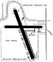
Runways
Runway Summary
| Runways: | 15/33 |
| Longest Runway: | 15/33 is 5006 ft (1526 m) long |
| Runways with an Instrument Approach: |
ONO Airport Runway Details
| Runway 15/33 | 5006 ft x 100 ft (1526 m x 30 m) | |
| Runway Length Source: | 3RD PARTY SURVEY as of 01/13/2016 | |
| Surface: | Asphalt - Fair condition - No special surface treatment | |
| Runway Edge Lights: | Medium Intensity | |
Runway Weight Bearing Capacity (in thousands of pounds) |
||
| Single Wheel Landing Gear: | 30.0 | |
| Dual Wheel Landing Gear: | 60.0 | |
Runway 15 |
Runway 33 |
|
Elevation: |
2193.1 | 2188.8 |
Latitude: |
44-01-32.6790N | 44-00-46.6583N |
Longitude: |
117-00-59.3545W | 117-00-34.3506W |
|
Runway True Alignment: |
158 | 338 |
Glide Path Angle: |
3.0 degrees | 3.0 degrees |
Traffic Pattern: |
Left | Left |
Runway Markings Type: |
Nonprecision Instrument | Nonprecision Instrument |
Runway Markings Condition: |
Good | Good |
Object at End: |
ROAD | |
Object Height: |
10 | |
Distance from End: |
380 | |
Visual Glide Slope Indicators: |
2-Light PAPI On Left Side Of Runway | 2-Light PAPI On Left Side Of Runway |
REIL: |
Yes | Yes |
Touchdown Lights: |
No | |
Centerline Lights: |
No | |
Threshold Crossing Height: |
40 | 40 |
Services
Airframe Repair: |
None |
Powerplant Repair: |
None |
Bottled Oxygen: |
None |
Bulk Oxygen: |
None |
Fuel Available: |
100LL |
Landing Fees: |
No |
Parking: |
Tiedowns available |
Maps & Diagrams
ONO Sectional
Flight Planning
at skyvector.com
at skyvector.com