Location
Latitude: |
44-12-16.8000N (44.204667) |
Longitude: |
116-57-37.9000W (-116.960528) |
Elevation: |
2120.3 feet MSL (646 m MSL) |
Magnetic Variation: |
13.2 E (as of April 2024 from WMM2020 model) |
Time Zone: |
UTC -7.0 (Standard Time) UTC -6.0 (Daylight Savings Time) |
From City: |
03 N.M. S of Weiser, Idaho |
Found On: |
Salt Lake City Chart |
FAA Region: |
ANM |
Contacts
Manager: |
Publicly owned: |
| JIM METZGER P O BOX 426 WEISER, ID 83672 (360)-903-6901 |
CITY OF WEISER 55 WEST IDAHO ST WEISER, ID 83672 208-414-1965 |
Operations
Airport Status: |
Operational |
Facility Use: |
Public |
Type: |
Airport |
Activation Date: |
12/1944 |
Control tower: |
No |
Attendance (Months/Days/Hours): |
Months/Days/Hours ALL/MON-SAT/0900 - 1700 |
Boundary ARTCC: |
ZLC (Salt Lake City) |
Responsible ARTCC: |
ZLC (Salt Lake City) |
Lighting Schedule: |
SEE RMK |
Segmented Circle Indicator: |
Yes |
Traffic Pattern Altitude (MSL): |
3120 feet (951 m) |
NOTAMs Facility: |
BOI |
NOTAM-D Service: |
Yes |
International Airport of Entry: |
No |
Customs Landing Rights: |
No |
Military Landing Rights: |
Yes |
Civil/Military Joint Use: |
No |
Based Aircraft
| Single Engine: | 22 |
| Multi Engine: | 1 |
| GA Helicopters: | 1 |
Annual Operations (as of 02/28/2023)
| Total Operations: | 5150 | |
| GA Local: | 3500 | 68.0% |
| GA Itinerant: | 1400 | 27.2% |
| Military Aircraft: | 250 | 4.9% |
Communications
| CTAF: | 122.800 |
| Unicom: | 122.800 |
- APCH/DEP CTL SVC PRVDD BY SALT LAKE CITY ARTCC (ZLC) ON FREQS 128.05/306.95 (SQUAW BUTTE RCAG).
Fixed Based Operators (FBOs) & Fuel
(Click on a business for detail)
Please help us keep this information up to date. This is a FREE SERVICE just like everything else on Airport Guide! If you see that a business needs to be added, modified, or deleted please fill out our Update Form.
To add, modify, or delete a business click here.
Please help us keep this information up to date. This is a FREE SERVICE just like everything else on Airport Guide! If you see that a business needs to be added, modified, or deleted please fill out our Update Form.
Area Code: 208 |
| Business Name | Frequency | Phone | Fuel Grade |
|---|---|---|---|
| Mountain View Aviation
Update FBO info |
Unicom 122.8 | 549-1965 | 100LL |
| Weiser Air Service
Update FBO info |
549-0712 |
Flight Service Stations
| Primary | Alternate | |
| FSS on Field: | N | |
| FSS Name (ID): | Boise(BOI) | |
| Frequency: | ||
| Toll Free Phone: | 1-800-WX-BRIEF |
Instrument Procedures / Charts
FAA Terminal Procedures valid from 0901Z 03/21/24 to 0901Z 04/18/24.
There are various types of charts available for an airport. They are listed in the Page Type column. Here is a legend for those types:
APD - Airport Diagram
DP - Departure Procedure Charts
HOT - Hot Spots
IAP - Instrument Approach Procedure Charts
MIN - Minimums
STAR - Standard Terminal Arrival Charts
| Page Type | Page Name | Volume | Action Since Last Cycle |
|---|---|---|---|
| IAP | RNAV (GPS)-A | NW-1 | |
| MIN | TAKEOFF MINIMUMS | NW-1 |
Terminal Procedures are only available for airports in several countries with more being added all the time. If you are looking for a specific country's charts, please send an email to support(at)airportguide.com stating the country name. This will be used to prioritize the implementation.
Navigation Aids (Navaids) near S87
| Dist (NM) | ID | Morse Code | Name | Type | Freq | True Hdg | Mag Hdg |
|---|---|---|---|---|---|---|---|
| 11.3 | ONO | _ _ _ _ . _ _ _ | Ontario | NDB | 305 | 190 | 177 |
| 40.4 | MPA | _ _ . _ _ . . _ | Meridian | NDB | 238 | 153 | 140 |
| 45.9 | BO | _ . . . _ _ _ | Ustik | NDB | 359 | 142 | 129 |
| 46.7 | DNJ | _ . . _ . . _ _ _ | Donnelly | VOR-DME | 116.20 | 43 | 30 |
| 50.4 | BOI | _ . . . _ _ _ . . | Boise | VOT | 116.70 | 140 | 127 |
| 51.3 | BOI | _ . . . _ _ _ . . | Boise | VORTAC | 113.30 | 139 | 126 |
| 52.6 | BKE | _ . . . _ . _ . | Baker City | VOR-DME | 115.30 | 316 | 303 |
| 80.5 | LGD | . _ . . _ _ . _ . . | La Grande | NDB | 296 | 328 | 315 |
| 84.3 | MUO | _ _ . . _ _ _ _ | Mountain Home | TACAN | 114.00 | 145 | 132 |
| 86.5 | STI | . . . _ . . | Sturgeon | NDB | 333 | 138 | 125 |
| 89.6 | LIA | . _ . . . . . _ | Liberator | VOR | 114.90 | 144 | 131 |
| 93.7 | ILR | . . . _ . . . _ . | Wildhorse | VOR-DME | 114.55 | 247 | 234 |
Nearby Airports with Fuel
Notices to Airmen (NOTAMS)
Remarks
| A110-1 | EXTSV AGRICULTURAL OPNS MAR-OCT. |
| A110-2 | BIRDS ON & INVOF ARPT. |
| A110-3 | FOR CD CTC SALT LAKE ARTCC AT 801-320-2568. |
| A53-12 | FENCE LIGHTED WITH RED OBSTRUCTION LIGHT |
| A81-APT | ACTVT MIRL RWY 12/30; REIL RWY 12 & 30 - 3 CLICKS ONLY ON CTAF. PAPI RWY 30 UNUSBL DURG GROWING SEASON MAY TO SEPTEMBER EACH YR, DUE TO VEGETATION/CROPS BLOCKING VIS OF LGTS. |
| E111 | ESTABD PRIOR TO 15 MAY 1959. |
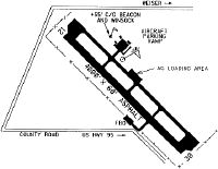
Runways
Runway Summary
| Runways: | 12/30 |
| Longest Runway: | 12/30 is 4000 ft (1219 m) long |
| Runways with an Instrument Approach: |
S87 Airport Runway Details
| Runway 12/30 | 4000 ft x 60 ft (1219 m x 18 m) | |
| Runway Length Source: | 3RD PARTY SURVEY as of 06/08/2011 | |
| Surface: | Asphalt - Good condition - No special surface treatment | |
| Runway Edge Lights: | Medium Intensity | |
Runway Weight Bearing Capacity (in thousands of pounds) |
||
| Single Wheel Landing Gear: | 12.5 | |
Runway 12 |
Runway 30 |
|
Elevation: |
2111.3 | 2120.3 |
Latitude: |
44-12-30.9473N | 44-12-02.6097N |
Longitude: |
116-57-57.0018W | 116-57-18.7580W |
|
Runway True Alignment: |
136 | 316 |
Glide Path Angle: |
0.0 degrees | 3.0 degrees |
Traffic Pattern: |
Left | Left |
Runway Markings Type: |
Nonprecision Instrument | Nonprecision Instrument |
Runway Markings Condition: |
Good | Good |
Object at End: |
TREES | FENCE |
Object Height: |
45 | 8 |
Distance from End: |
800 | 200 |
Object Centerline Offset: |
0 ft. left and right of centerline | 190 ft. left of centerline |
Visual Glide Slope Indicators: |
4-Light PAPI On Left Side Of Runway | |
REIL: |
Yes | Yes |
Threshold Crossing Height: |
38 |
Services
Airframe Repair: |
Major |
Powerplant Repair: |
Major |
Bottled Oxygen: |
None |
Bulk Oxygen: |
None |
Fuel Available: |
100LL, Jet A |
Landing Fees: |
No |
Parking: |
Tiedowns available |
Maps & Diagrams
S87 Sectional
Flight Planning
at skyvector.com
at skyvector.com