Location
Latitude: |
42-53-28.7890N (42.89133) |
Longitude: |
073-14-47.0550W (-73.246404) |
Elevation: |
826.8 feet MSL (252 m MSL) |
Magnetic Variation: |
13.4 W (as of May 2024 from WMM2020 model) |
Time Zone: |
UTC -5.0 (Standard Time) UTC -4.0 (Daylight Savings Time) |
From City: |
03 N.M. W of Bennington, Vermont |
Found On: |
New York Chart |
FAA Region: |
ANE |
Contacts
Manager: |
Publicly owned: |
| ROLLIN TEBBETTS 219 N MAIN ST BARRE, VT 05641 802-585-5586 |
STATE OF VERMONT 219 N MAIN ST BARRE, VT 05641 802-279-2647 |
Operations
Airport Status: |
Operational |
Facility Use: |
Public |
Type: |
Airport |
Activation Date: |
12/1937 |
Control tower: |
No |
Attendance (Months/Days/Hours): |
Months/Days/Hours ALL/SAT-SUN/ON CALL |
Boundary ARTCC: |
ZBW (Boston) |
Responsible ARTCC: |
ZBW (Boston) |
Lighting Schedule: |
SEE RMK |
Segmented Circle Indicator: |
Yes |
Traffic Pattern Altitude (MSL): |
1827 feet (557 m) |
NOTAMs Facility: |
DDH |
NOTAM-D Service: |
Yes |
International Airport of Entry: |
No |
Customs Landing Rights: |
No |
Military Landing Rights: |
Yes |
Civil/Military Joint Use: |
No |
Based Aircraft
| Single Engine: | 23 |
| Multi Engine: | 3 |
Annual Operations (as of 08/28/2017)
| Total Operations: | 14377 | |
| GA Local: | 5625 | 39.1% |
| GA Itinerant: | 8627 | 60.0% |
| Military Aircraft: | 125 | 0.9% |
Communications
| CTAF: | 122.800 |
| Unicom: | 122.800 |
| Approach: | ALBANY 132.825 132.825 |
| Departure: | ALBANY 132.825 132.825 |
| ASOS: | 135.925 (802-442-6059) |
Fixed Based Operators (FBOs) & Fuel
(Click on a business for detail)
Please help us keep this information up to date. This is a FREE SERVICE just like everything else on Airport Guide! If you see that a business needs to be added, modified, or deleted please fill out our Update Form.
To add, modify, or delete a business click here.
Please help us keep this information up to date. This is a FREE SERVICE just like everything else on Airport Guide! If you see that a business needs to be added, modified, or deleted please fill out our Update Form.
Area Code: 802 |
| Business Name | Frequency | Phone | Fuel Grade |
|---|---|---|---|
| New England Airmotive
Website Update FBO info |
122.8 | 802-430-8130 | |

|
 Shell |
100LL - 5.39 USD per gallon on 2/1/14 |
24 Hour Self-Serve Credit Card Pumps Full Service Available also |
|
|
Shell |
Jet A - 4.99 USD per gallon on 2/1/14 |
24 Hour Self-Serve Credit Card Pumps Full Service Available also |
Flight Service Stations
| Primary | Alternate | |
| FSS on Field: | N | |
| FSS Name (ID): | Burlington(BTV) | |
| Frequency: | ||
| Toll Free Phone: | 1-800-WX-BRIEF |
Instrument Procedures / Charts
FAA Terminal Procedures valid from 0901Z 03/21/24 to 0901Z 04/18/24.
There are various types of charts available for an airport. They are listed in the Page Type column. Here is a legend for those types:
APD - Airport Diagram
DP - Departure Procedure Charts
HOT - Hot Spots
IAP - Instrument Approach Procedure Charts
MIN - Minimums
STAR - Standard Terminal Arrival Charts
| Page Type | Page Name | Volume | Action Since Last Cycle |
|---|---|---|---|
| IAP | RNAV (GPS) RWY 13 | NE-1 | |
| MIN | TAKEOFF MINIMUMS | NE-1 |
Terminal Procedures are only available for airports in several countries with more being added all the time. If you are looking for a specific country's charts, please send an email to support(at)airportguide.com stating the country name. This will be used to prioritize the implementation.
Navigation Aids (Navaids) near KDDH
| Dist (NM) | ID | Morse Code | Name | Type | Freq | True Hdg | Mag Hdg |
|---|---|---|---|---|---|---|---|
| 7.5 | CAM | _ . _ . . _ _ _ | Cambridge | VOR-DME | 115.00 | 325 | 338 |
| 16.9 | VWD | . . . _ . _ _ _ . . | Mount Snow | NDB | 224 | 82 | 95 |
| 26.0 | ALB | . _ . _ . . _ . . . | Albany | VORTAC | 115.30 | 250 | 263 |
| 26.9 | ALB | . _ . _ . . _ . . . | Albany | VOT | 108.20 | 250 | 263 |
| 26.9 | GF | _ _ . . . _ . | Ganse | NDB | 209 | 324 | 337 |
| 30.3 | HEU | . . . . . . . _ | Hunter | NDB | 356 | 266 | 279 |
| 31.4 | GFL | _ _ . . . _ . . _ . . | Glens Falls | VORTAC | 110.20 | 329 | 342 |
| 36.8 | SXD | . . . _ . . _ _ . . | Springfield | NDB | 265 | 51 | 65 |
| 38.3 | CTR | _ . _ . _ . _ . | Chester | VOR-DME | 115.10 | 159 | 172 |
| 40.3 | RUT | . _ . . . _ _ | Rutland | DME | 111 | 18 | 32 |
| 42.4 | EEN | . . _ . | Keene | DME | 109.4 | 97 | 111 |
| 43.1 | GBR | _ _ . _ . . . . _ . | Great Barrington | NDB | 395 | 189 | 202 |
| 43.7 | PFH | . _ _ . . . _ . . . . . | Philmont | NDB | 272 | 208 | 221 |
| 46.4 | R | . _ . | Chitt | FAN MARKER | 15 | 29 | |
| 46.5 | ORE | _ _ _ . _ . . | Orange | NDB | 205 | 114 | 128 |
| 47.9 | CNH | _ . _ . _ . . . . . | Claremont | NDB | 233 | 52 | 66 |
| 48.1 | JJH | . _ _ _ . _ _ _ . . . . | Johnstown | NDB | 523 | 278 | 291 |
| 49.6 | BAF | _ . . . . _ . . _ . | Barnes | VORTAC | 113.00 | 151 | 164 |
| 50.5 | DYO | _ . . _ . _ _ _ _ _ | Smuto | NDB | 221 | 14 | 28 |
| 52.4 | CEF | _ . _ . . . . _ . | Westover | TACAN | 114.00 | 142 | 155 |
Nearby Airports with Fuel
Notices to Airmen (NOTAMS)
Remarks
| A110*G | THIS AIRPORT HAS BEEN SURVEYED BY THE NATIONAL GEODETIC SURVEY. |
| A110-1 | RWY CONDS MAY NOT BE MNT OR RPRTD WHEN ARPT IS UNATNDD. |
| A110-10 | FOR CD CTC ALBANY APCH AT 518-862-2299. |
| A110-2 | NOISE ABATEMENT PROCS IN EFCT. AVOID OVER FLYING HOMES SE OF ARPT. NOISE SENSITIVE AREA AER 31. PREFERRED USE RWY IS RWY 13. IF PRACTICAL ACFT DEP RWY 13 USE BEST CLIMB RATE & WHEN ABOVE 400 FT AGL TURN LEFT WITHIN 1 MILE OF DER 13. |
| A110-4 | GEESE ON & INVOF ARPT. |
| A110-5 | GCO AVBL ON FREQ 121.725 THRU BTV CD & FLT SVCS. OTS INDEFLY. |
| A110-6 | RWY 13 THR HAZUS BIRD ACTVTY. |
| A110-7 | MTS ALL QUADS. |
| A110-8 | TFC PAT OPS PROHIBITED S OF RWY 13 & RWY 31. |
| A110-9 | COLD TEMPERATURE AIRPORT. ALTITUDE CORRECTION REQUIRED AT OR BELOW -14C. |
| A17 | FOR ARPT ATNDNC CALL 1-802-442-5503 OR 1-802-595-5830 FOR ON-CALL SVCS ONLY. |
| A58-31 | +20 FT GND, 250 FT R OF CNTRLN. |
| A70-FUEL-10 | 0LL 100LL SELF-SVC AVBL 24 HRS. |
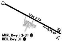
| A81-APT | ACTVT REIL RWY 13 & 31; PAPI RWY 13 & 31; MIRL RWY 13/31 - CTAF. |
| E111 | EXISTED PRIOR TO 1959. |
Runways
Runway Summary
| Runways: | 13/31 |
| Longest Runway: | 13/31 is 3704 ft (1129 m) long |
| Runways with an Instrument Approach: |
KDDH Airport Runway Details
| Runway 13/31 | 3704 ft x 75 ft (1129 m x 23 m) | |
| Runway Length Source: | NGS as of 09/13/2006 | |
| Surface: | Asphalt - Fair condition - No special surface treatment | |
| Runway Edge Lights: | Medium Intensity | |
Runway Weight Bearing Capacity (in thousands of pounds) |
||
| Single Wheel Landing Gear: | 12.5 | |
Runway 13 |
Runway 31 |
|
Elevation: |
793.5 | 826.8 |
Latitude: |
42-53-37.4836N | 42-53-20.0936N |
Longitude: |
073-15-08.9409W | 073-14-25.1704W |
|
Runway True Alignment: |
118 | 298 |
Glide Path Angle: |
4.0 degrees | 4.0 degrees |
Traffic Pattern: |
Left | Right |
Runway Markings Type: |
Nonprecision Instrument | Basic |
Runway Markings Condition: |
Fair | Fair |
Object at End: |
HILL | GND |
Object Height: |
159 | 40 |
Distance from End: |
2781 | 509 |
Object Centerline Offset: |
549 ft. right of centerline | 178 ft. left of centerline |
Visual Glide Slope Indicators: |
4-Light PAPI On Left Side Of Runway | 4-Light PAPI On Right Side Of Runway |
REIL: |
Yes | Yes |
Threshold Crossing Height: |
45 | 45 |
Services
Airframe Repair: |
None |
Powerplant Repair: |
None |
Fuel Available: |
Mogas |
Landing Fees: |
No |
Parking: |
Tiedowns available |
Maps & Diagrams
KDDH Sectional
Flight Planning
at skyvector.com
at skyvector.com