Location
Latitude: |
43-22-13.8160N (43.370504) |
Longitude: |
072-22-05.5450W (-72.368207) |
Elevation: |
543.3 feet MSL (166 m MSL) |
Magnetic Variation: |
13.8 W (as of April 2024 from WMM2020 model) |
Time Zone: |
UTC -5.0 (Standard Time) UTC -4.0 (Daylight Savings Time) |
From City: |
01 N.M. W of Claremont, New Hampshire |
Found On: |
New York Chart |
FAA Region: |
ANE |
Contacts
Manager: |
Publicly owned: |
| JAMES CHAMBERLAIN 100 BROAD ST CLAREMONT, NH 03743 (603) 542-5156 |
CITY OF CLAREMONT CITY HALL CLAREMONT, NH 03743 603-542-7002 |
Operations
Airport Status: |
Operational |
Facility Use: |
Public |
Type: |
Airport |
Control tower: |
No |
Attendance (Months/Days/Hours): |
Months/Days/Hours ALL/MON-FRI/1000-1600 |
Boundary ARTCC: |
ZBW (Boston) |
Responsible ARTCC: |
ZBW (Boston) |
Lighting Schedule: |
SEE RMK |
Segmented Circle Indicator: |
Yes |
Traffic Pattern Altitude (MSL): |
1543 feet (470 m) |
NOTAMs Facility: |
BGR |
NOTAM-D Service: |
Yes |
International Airport of Entry: |
No |
Customs Landing Rights: |
No |
Military Landing Rights: |
Yes |
Civil/Military Joint Use: |
No |
Based Aircraft
| Single Engine: | 16 |
| Multi Engine: | 2 |
Annual Operations (as of 08/01/2018)
| Total Operations: | 4144 | |
| GA Local: | 2544 | 61.4% |
| GA Itinerant: | 1550 | 37.4% |
| Military Aircraft: | 50 | 1.2% |
Communications
| CTAF: | 122.700 |
| Unicom: | 122.700 |
- APCH/DEP SVC PRVDD BY BOSTON ARTCC ON FREQS 134.7/269.475 (LEBANON RCAG).
Fixed Based Operators (FBOs) & Fuel
(Click on a business for detail)
Please help us keep this information up to date. This is a FREE SERVICE just like everything else on Airport Guide! If you see that a business needs to be added, modified, or deleted please fill out our Update Form.
To add, modify, or delete a business click here.
Please help us keep this information up to date. This is a FREE SERVICE just like everything else on Airport Guide! If you see that a business needs to be added, modified, or deleted please fill out our Update Form.
Area Code: 603 |
| Business Name | Frequency | Phone | Fuel Grade |
|---|---|---|---|
| August Avionics
Update FBO info |
543-1180 | 100LL |
Flight Service Stations
| Primary | Alternate | |
| FSS on Field: | N | |
| FSS Name (ID): | Bangor(BGR) | |
| Frequency: | ||
| Toll Free Phone: | 1-800-WX-BRIEF |
Instrument Procedures / Charts
FAA Terminal Procedures valid from 0901Z 03/21/24 to 0901Z 04/18/24.
There are various types of charts available for an airport. They are listed in the Page Type column. Here is a legend for those types:
APD - Airport Diagram
DP - Departure Procedure Charts
HOT - Hot Spots
IAP - Instrument Approach Procedure Charts
MIN - Minimums
STAR - Standard Terminal Arrival Charts
| Page Type | Page Name | Volume | Action Since Last Cycle |
|---|---|---|---|
| IAP | NDB-A | NE-1 | |
| IAP | RNAV (GPS) RWY 29 | NE-1 | |
| MIN | TAKEOFF MINIMUMS | NE-1 |
Terminal Procedures are only available for airports in several countries with more being added all the time. If you are looking for a specific country's charts, please send an email to support(at)airportguide.com stating the country name. This will be used to prioritize the implementation.
Navigation Aids (Navaids) near CNH
| Dist (NM) | ID | Morse Code | Name | Type | Freq | True Hdg | Mag Hdg |
|---|---|---|---|---|---|---|---|
| 0.2 | CNH | _ . _ . _ . . . . . | Claremont | NDB | 233 | 239 | 253 |
| 11.3 | SXD | . . . _ . . _ _ . . | Springfield | NDB | 265 | 237 | 251 |
| 12.1 | IVV | . . . . . _ . . . _ | White River | NDB | 379 | 339 | 353 |
| 19.7 | LEB | . _ . . . _ . . . | Lebanon | DME | 113.7 | 19 | 33 |
| 21.6 | LAH | . _ . . . _ . . . . | Hanover | NDB | 276 | 22 | 36 |
| 27.1 | RUT | . _ . . . _ _ | Rutland | DME | 111 | 290 | 304 |
| 30.0 | R | . _ . | Chitt | FAN MARKER | 302 | 316 | |
| 32.6 | DYO | _ . . _ . _ _ _ _ _ | Smuto | NDB | 221 | 308 | 322 |
| 34.3 | VWD | . . . _ . _ _ _ . . | Mount Snow | NDB | 224 | 219 | 233 |
| 34.7 | EEN | . . _ . | Keene | DME | 109.4 | 174 | 188 |
| 35.8 | CON | _ . _ . _ _ _ _ . | Concord | VOR-DME | 112.90 | 104 | 118 |
| 37.6 | LC | . _ . . _ . _ . | Blnap | NDB | 328 | 74 | 88 |
| 42.1 | LCI | . _ . . _ . _ . . . | Laconia | FAN MARKER | 73 | 87 | |
| 42.8 | CO | _ . _ . _ _ _ | Epsom | NDB | 216 | 110 | 124 |
| 43.0 | MPV | _ _ . _ _ . . . . _ | Montpelier | VOR-DME | 116.90 | 355 | 369 |
| 46.9 | AS | . _ . . . | Chern | NDB | 359 | 134 | 148 |
| 47.7 | MJ | _ _ . _ _ _ | Fitzy | NDB | 209 | 129 | 143 |
| 48.2 | ORE | _ _ _ . _ . . | Orange | NDB | 205 | 175 | 189 |
| 48.3 | CAM | _ . _ . . _ _ _ | Cambridge | VOR-DME | 115.00 | 242 | 256 |
| 51.3 | GDM | _ _ . _ . . _ _ | Gardner | VOR-DME | 110.60 | 164 | 178 |
Nearby Airports with Fuel
Notices to Airmen (NOTAMS)
Remarks
| A110-1 | HAZ BCNS ON SRNDG HILLS. |
| A110-2 | EXPC DOWNDRAFT ON APCH TO RWY 29. |
| A110-4 | TKOF, LNDG & TAX ON UNPAVED AREAS PROHIBITED. |
| A110-5 | WILDLIFE ON & INVOF ARPT. |
| A110-6 | COLD TEMPERATURE AIRPORT. ALTITUDE CORRECTION REQUIRED AT OR BELOW -25C. |
| A110-7 | FOR CD CTC BOSTON ARTCC AT 603-879-6859. |
| A17 | FOR ARPT SVCS, CALL 603-542-2282. |
| A39-11/29 | PCR VALUE: 383/F/A/X/T |
| A70-FUEL-10 | 0LL FUEL SELF SVC 24 HRS BY CREDIT CARD. |
| A80 | ROTG BCN DFCLT TO SEE FM THE N WHEN FOLIAGE IS ON THE TREES. |
| A81-APT | ACTVT REIL RWY 29; MIRL RWY 11/29 - CTAF. |
| E111 | ESTAB PRIOR TO 1959. |
Runways
Runway Summary
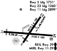
| Runways: | 11/29 |
| Longest Runway: | 11/29 is 3098 ft (944 m) long |
| Runways with an Instrument Approach: |
CNH Airport Runway Details
| Runway 11/29 | 3098 ft x 75 ft (944 m x 23 m) | |
| Runway Length Source: | 3RD PARTY SURVEY as of 10/13/2022 | |
| Surface: | Asphalt - Excellent condition - No special surface treatment | |
| Runway Edge Lights: | Medium Intensity | |
Runway Weight Bearing Capacity (in thousands of pounds) |
||
| Single Wheel Landing Gear: | 30.0 | |
Runway 11 |
Runway 29 |
|
Elevation: |
532.8 | 541.9 |
Latitude: |
43-22-14.6613N | 43-22-12.9696N |
Longitude: |
072-22-26.4865W | 072-21-44.6041W |
|
Runway True Alignment: |
093 | 273 |
Glide Path Angle: |
0.0 degrees | 4.0 degrees |
Traffic Pattern: |
Left | Left |
Runway Markings Type: |
Basic | Nonprecision Instrument |
Runway Markings Condition: |
Good | Good |
Visual Glide Slope Indicators: |
2-Light PAPI On Left Side Of Runway | |
REIL: |
No | Yes |
Threshold Crossing Height: |
31 |
Services
Airframe Repair: |
Major |
Powerplant Repair: |
Major |
Bottled Oxygen: |
None |
Bulk Oxygen: |
None |
Fuel Available: |
100LL, Jet A, Jet A+ |
Landing Fees: |
Yes |
Parking: |
Hangars and tiedowns available |
Maps & Diagrams
CNH Sectional
Flight Planning
at skyvector.com
at skyvector.com