Location
Latitude: |
37-23-03.4000N (37.384278) |
Longitude: |
100-11-10.3000W (-100.186194) |
Elevation: |
2483.0 feet MSL (757 m MSL) |
Magnetic Variation: |
4.8 E (as of April 2024 from WMM2020 model) |
Time Zone: |
UTC -6.0 (Standard Time) UTC -5.0 (Daylight Savings Time) |
From City: |
00 N.M. E of Fowler, Kansas |
Found On: |
Wichita Chart |
FAA Region: |
ACE |
Contacts
Manager: |
Privately owned: |
| LARRY DEWELL 7009 COUNTY ROAD #27 FOWLER, KS 67844 620-338-1576 |
LARRY DEWELL 7009 COUNTY ROAD #27 FOWLER, KS 67844 (620) 338-1576 |
Operations
Airport Status: |
Operational |
Facility Use: |
Public |
Type: |
Airport |
Activation Date: |
08/1975 |
Control tower: |
No |
Attendance (Months/Days/Hours): |
Months/Days/Hours Unattended |
Boundary ARTCC: |
ZKC (Kansas City) |
Responsible ARTCC: |
ZKC (Kansas City) |
Segmented Circle Indicator: |
No |
Traffic Pattern Altitude (MSL): |
3483 feet (1062 m) |
NOTAMs Facility: |
ICT |
NOTAM-D Service: |
Yes |
Based Aircraft
| Single Engine: | 2 |
Annual Operations (as of 08/30/2021)
| Total Operations: | 1000 | |
| GA Local: | 700 | 70.0% |
| GA Itinerant: | 300 | 30.0% |
Communications
| CTAF: | 122.900 |
Fixed Based Operators (FBOs) & Fuel
(Click on a business for detail)
Please help us keep this information up to date. This is a FREE SERVICE just like everything else on Airport Guide! If you see that a business needs to be added, modified, or deleted please fill out our Update Form.
To add, modify, or delete a business click here.
Please help us keep this information up to date. This is a FREE SERVICE just like everything else on Airport Guide! If you see that a business needs to be added, modified, or deleted please fill out our Update Form.
Area Code: 620 |
| Business Name | Frequency | Phone | Fuel Grade |
|---|
Flight Service Stations
| Primary | Alternate | |
| FSS on Field: | N | |
| FSS Name (ID): | Wichita(ICT) | |
| Frequency: | ||
| Toll Free Phone: | 1-800-WX-BRIEF |
Instrument Procedures / Charts
Terminal Procedures are only available for airports in several countries with more being added all the time. If you are looking for a specific country's charts, please send an email to support(at)airportguide.com stating the country name. This will be used to prioritize the implementation.
Navigation Aids (Navaids) near 18K
| Dist (NM) | ID | Morse Code | Name | Type | Freq | True Hdg | Mag Hdg |
|---|---|---|---|---|---|---|---|
| 29.3 | DDC | _ . . _ . . _ . _ . | Dodge City | VORTAC | 108.20 | 16 | 11 |
| 37.0 | GC | _ _ . _ . _ . | Pieve | NDB | 347 | 316 | 311 |
| 41.0 | GCK | _ _ . _ . _ . _ . _ | Garden City | VORTAC | 113.30 | 321 | 316 |
| 41.3 | BFK | _ . . . . . _ . _ . _ | Buffalo | NDB | 215 | 138 | 133 |
| 42.7 | LBL | . _ . . _ . . . . _ . . | Liberal | TACAN | 112.30 | 241 | 236 |
| 44.6 | LB | . _ . . _ . . . | Panck | NDB | 383 | 235 | 230 |
| 57.7 | ULS | . . _ . _ . . . . . | Ulysses | NDB | 395 | 283 | 278 |
| 58.3 | HQG | . . . . _ _ . _ _ _ . | Hugoton | NDB | 365 | 257 | 252 |
| 64.1 | MMB | _ _ _ _ _ . . . | Mitbee | VORTAC | 115.60 | 166 | 161 |
| 64.2 | PYX | . _ _ . _ . _ _ _ . . _ | Perryton | NDB | 266 | 204 | 199 |
| 71.5 | PTT | . _ _ . _ _ | Pratt | NDB | 356 | 72 | 68 |
| 71.6 | LQR | . _ . . _ _ . _ . _ . | Larned | NDB | 296 | 46 | 42 |
| 71.9 | MDF | _ _ _ . . . . _ . | Mooreland | NDB | 284 | 138 | 134 |
| 73.7 | TQK | _ _ _ . _ _ . _ | Scott City | NDB | 256 | 333 | 328 |
| 75.2 | GUY | _ _ . . . _ _ . _ _ | Guymon | NDB | 275 | 237 | 232 |
| 75.2 | JHN | . _ _ _ . . . . _ . | Bear Creek | NDB | 341 | 282 | 277 |
| 81.8 | GB | _ _ . _ . . . | Babsy | NDB | 419 | 50 | 46 |
| 84.4 | HIL | . . . . . . . _ . . | Hilyn | NDB | 338 | 45 | 41 |
| 84.4 | EHA | . . . . . . _ | Elkhart | NDB | 377 | 254 | 249 |
| 94.1 | HY | . . . . _ . _ _ | Nette | NDB | 374 | 27 | 22 |
Nearby Airports with Fuel
Notices to Airmen (NOTAMS)
Remarks
| A110-1 | FOR CD CTC KANSAS CITY ARTCC AT 913-254-8508. |
| A16 | OR 620-646-5761. |
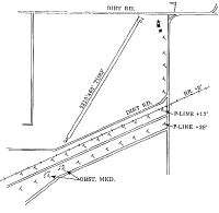
| A42-03 | RWY 03 /21 MKD WITH SMALL RED REFLECTORS: SOLAR LIGHTS & RED CONES. |
| A52-03 | RWY 03 +28' POLES LGTD PLINE APRX 450' S OF SW END OF RWY. |
| E111 | PROVIDED APCH SLOPES ARE CLEARED, THR DSPLCD SUFFICIENT DIST THAT THE ROADS, RR, & PWR LINES WOULD NO LONGER PRESENT A PSBL UNSAFE COND FOR ACFT. |
Runways
Runway Summary
| Runways: | 03/21 |
| Longest Runway: | 03/21 is 2310 ft (704 m) long |
| Runways with an Instrument Approach: |
18K Airport Runway Details
| Runway 03/21 | 2310 ft x 100 ft (704 m x 30 m) | |
| Surface: | Turf - Fair condition - No special surface treatment | |
Runway 03 |
Runway 21 |
|
Latitude: |
37-22-53.6400N | 37-23-13.2300N |
Longitude: |
100-11-17.6300W | 100-11-02.9000W |
Glide Path Angle: |
0.0 degrees | 0.0 degrees |
Object at End: |
ROAD | ROAD |
Object Height: |
15 | 15 |
Distance from End: |
45 | 150 |
Object Centerline Offset: |
0 ft. left and right of centerline | 0 ft. left and right of centerline |
Services
Fuel Available: |
100LL |
Landing Fees: |
No |
Parking: |
Tiedowns available |
Maps & Diagrams
18K Sectional
Flight Planning
at skyvector.com
at skyvector.com