Location
Latitude: |
43-30-13.6100N (43.503781) |
Longitude: |
114-17-44.0100W (-114.295558) |
Elevation: |
5319.5 feet MSL (1621 m MSL) |
Magnetic Variation: |
12.2 E (as of May 2024 from WMM2020 model) |
Time Zone: |
UTC -7.0 (Standard Time) UTC -6.0 (Daylight Savings Time) |
From City: |
01 N.M. SE of Hailey, Idaho |
Found On: |
Salt Lake City Chart |
FAA Region: |
ANM |
Contacts
Manager: |
Publicly owned: |
| CHRIS POMEROY 1616 AIRPORT CIR HAILEY, ID 83333-5534 208-788-4956 |
CITY OF HAILEY BLANE CO - BOX 400 HAILEY, ID 83333 (208) 788-4221 |
Operations
Airport Status: |
Operational |
Facility Use: |
Public |
Type: |
Airport |
Activation Date: |
04/1940 |
Control tower: |
Yes |
Attendance (Months/Days/Hours): |
Months/Days/Hours ALL/ALL/0700-2300 |
Boundary ARTCC: |
ZLC (Salt Lake City) |
Responsible ARTCC: |
ZLC (Salt Lake City) |
Lighting Schedule: |
SEE RMK |
Segmented Circle Indicator: |
No |
Traffic Pattern Altitude (MSL): |
6320 feet (1926 m) |
NOTAMs Facility: |
SUN |
NOTAM-D Service: |
Yes |
International Airport of Entry: |
No |
Customs Landing Rights: |
No |
Military Landing Rights: |
Yes |
Civil/Military Joint Use: |
No |
Aircraft Rescue and Firefighting: |
Class I ARFF Index: B Air Carrier Service: Scheduled Certification Date: 10/1974 |
Based Aircraft
| Single Engine: | 92 |
| Multi Engine: | 17 |
| Jet Engine: | 47 |
| GA Helicopters: | 1 |
Annual Operations (as of 12/31/2018)
| Total Operations: | 26571 | |
| Commercial: | 3391 | 12.8% |
| Air Taxi: | 6271 | 23.6% |
| GA Local: | 1852 | 7.0% |
| GA Itinerant: | 14983 | 56.4% |
| Military Aircraft: | 74 | 0.3% |
Communications
| CTAF: | 125.600 |
| Unicom: | 122.950 |
| Tower: | HAILEY 125.6 Hrs: 0700-2300 |
| Ground: | 121.7 |
| Approach: | SALT LAKE ARTCC |
| Departure: | SALT LAKE ARTCC |
| ATIS: | 128.225 Hrs: 24 |
| AWOS-3: | 128.225 (208-788-9213) |
- APCH/DEP CTL SVC PRVDD BY SALT LAKE ARTCC (ZLC) ON FREQS 118.05/363.0 (BURLEY RCAG).
- FREQ 121.5 NOT AVBL AT TWR.
- ATCT CONTRACTED TO BLAINE COUNTY ARPT COMMISSION.
Fixed Based Operators (FBOs) & Fuel
(Click on a business for detail)
Please help us keep this information up to date. This is a FREE SERVICE just like everything else on Airport Guide! If you see that a business needs to be added, modified, or deleted please fill out our Update Form.
To add, modify, or delete a business click here.
Please help us keep this information up to date. This is a FREE SERVICE just like everything else on Airport Guide! If you see that a business needs to be added, modified, or deleted please fill out our Update Form.
Area Code: 208 |
| Business Name | Frequency | Phone | Fuel Grade |
|---|---|---|---|
| Sun Valley Aviation
Update FBO info |
Unicom 122.95 | 788-9511 | 100LL, Jet A |
Flight Service Stations
| Primary | Alternate | |
| FSS on Field: | N | |
| FSS Name (ID): | Boise(BOI) | |
| Frequency: | ||
| Toll Free Phone: | 1-800-WX-BRIEF |
Instrument Procedures / Charts
FAA Terminal Procedures valid from 0901Z 03/21/24 to 0901Z 04/18/24.
There are various types of charts available for an airport. They are listed in the Page Type column. Here is a legend for those types:
APD - Airport Diagram
DP - Departure Procedure Charts
HOT - Hot Spots
IAP - Instrument Approach Procedure Charts
MIN - Minimums
STAR - Standard Terminal Arrival Charts
| Page Type | Page Name | Volume | Action Since Last Cycle |
|---|---|---|---|
| APD | AIRPORT DIAGRAM | NW-1 | |
| DP | AURELIA THREE (RNAV) | NW-1 | |
| HOT | HOT SPOT | NW-1 | |
| IAP | NDB/DME-A | NW-1 | Changed |
| IAP | RNAV (GPS) X RWY 31 | NW-1 | Changed |
| IAP | RNAV (GPS) Y RWY 31 | NW-1 | Changed |
| MIN | ALTERNATE MINIMUMS | NW-1 | |
| MIN | TAKEOFF MINIMUMS | NW-1 |
Terminal Procedures are only available for airports in several countries with more being added all the time. If you are looking for a specific country's charts, please send an email to support(at)airportguide.com stating the country name. This will be used to prioritize the implementation.
Navigation Aids (Navaids) near SUN
| Dist (NM) | ID | Morse Code | Name | Type | Freq | True Hdg | Mag Hdg |
|---|---|---|---|---|---|---|---|
| 10.7 | HLE | . . . . . _ . . . | Hailey | NDB-DME | 220 | 167 | 155 |
| 39.0 | HDG | . . . . _ . . _ _ . | Steelhead | NDB | 211 | 205 | 193 |
| 58.5 | BYI | _ . . . _ . _ _ . . | Burley | VOR-DME | 114.10 | 161 | 149 |
| 61.6 | TW | _ . _ _ | Strik | NDB | 389 | 182 | 170 |
| 62.0 | TWF | _ . _ _ . . _ . | Twin Falls | VORTAC | 113.10 | 187 | 175 |
| 64.0 | STI | . . . _ . . | Sturgeon | NDB | 333 | 248 | 236 |
| 71.8 | LIA | . _ . . . . . _ | Liberator | VOR | 114.90 | 244 | 232 |
| 74.4 | MUO | _ _ . . _ _ _ _ | Mountain Home | TACAN | 114.00 | 248 | 236 |
| 81.3 | PIH | . _ _ . . . . . . . | Pocatello | VOR-DME | 112.60 | 117 | 105 |
| 82.6 | BOI | _ . . . _ _ _ . . | Boise | VORTAC | 113.30 | 272 | 260 |
| 83.8 | BOI | _ . . . _ _ _ . . | Boise | VOT | 116.70 | 272 | 259 |
| 84.3 | PI | . _ _ . . . | Tyhee | NDB | 383 | 112 | 100 |
| 88.0 | BO | _ . . . _ _ _ | Ustik | NDB | 359 | 274 | 261 |
| 91.5 | LKT | . _ . . _ . _ _ | Salmon | VOR-DME | 113.50 | 5 | 353 |
| 93.0 | SWU | . . . . _ _ . . _ | Sweden | NDB | 350 | 91 | 79 |
| 96.9 | DBS | _ . . _ . . . . . . | Dubois | VORTAC | 116.90 | 68 | 56 |
| 97.1 | IDA | . . _ . . . _ | Idaho Falls | VOR-DME | 113.85 | 88 | 76 |
| 97.7 | MPA | _ _ . _ _ . . _ | Meridian | NDB | 238 | 274 | 261 |
Nearby Airports with Fuel
Notices to Airmen (NOTAMS)
Remarks
| A11 | AND CO OF BLAINE 208-788-5500. |
| A110-1 | WHEN ATCT CLSD - LAND RY 31 TAKEOFF RY 13; DUE TO OPPOSITE DIRECTION TRAFFIC USE LANDING LIGHT IN TRAFFIC PATTERN. |
| A110-11 | DUE TO OPPOSITE TFC: APCH RY 31 ALONG E SIDE OF VALLEY: DEP RY 13 ALONG W SIDE OF VALLEY: SHOW LNGD LGT. |
| A110-12 | NO LOCKED BRAKE TURNS. |
| A110-18 | ARPT SFC CONDS NOT MNTD AND ARFF NOT AVBL BTN THE HRS OF 2300 AND 0700. |
| A110-19 | LTD PARKG AVBL FOR AIR CARRIER ACFT. |
| A110-2 | NOT RCMDD FOR NIGHT USE OR IN MARGINAL WEATHER BY UNFAMILIAR PILOTS DUE TO MOUNTAINOUS TERRAIN. |
| A110-20 | RWY 13/31 LTD TO ACFT NOT EXCEEDING 95000 LBS CERTD MAX TKOF WT: DUAL WHEEL. ACFT WITH PUBLD MAX TKOF WT EXCEEDING 95000 LBS MUST SEEK PPR AT LEAST 48 HRS IN ADVANCE BY SMTG TO AMGR A MANUFACTURER'S ACFT SVC CHG THAT INSTLS A PLACARD VFYG ACFT IS CERTD FOR SUN WITH A MAX TKOF WT OF 95000 LBS. PPR FOR ALL ACFT WITH PUBLD WINGSPAN EXCEEDING 100 FT (30.48M). |
| A110-21 | ATCT 275 FT EAST OF RY 13/31 CNTRLN. |
| A110-22 | CTC AMGR 208-788-4956 OR 208-720-5186 FOR NOISE ABATEMENT PROCEDURES. |
| A110-23 | APU OPERATION LIMITED TO 30 MINUTE MAXIMUM RUN TIME. |
| A110-24 | TWYS B5 AND B6 RSTD TO ACFT WITH WINGSPANS OF 79 FT OR LESS (ACFT DESIGN GROUP II) ONLY. |
| A110-25 | ALL TRANSIENT PARKING CTC 208-788-9511. |
| A110-26 | COLD TEMPERATURE AIRPORT. ALTITUDE CORRECTION REQUIRED AT OR BELOW -14C. |
| A110-27 | ALL TRANSIENT HELICOPTER OPS CTL - 208-720-5186 ARPT OPS; 208-788-9511 FBO FOR PARKING INSTRUCTIONS. NO DEDICATED HELICOPTER PARKING PADS EXIST. |
| A110-28 | FOR CD IF UNA TO CTC ON FSS FREQ, CTC SALT LAKE ARTCC AT 801-320-2568. |
| A110-29 | ALL ARRG ACFT FM 2300 TO 0700L REQD TO ANNC CTAF 125.6 WHEN THEY ARE 20, 15, 10 AND 5 MIS OUT AND SHRT FINAL. EQPT MAY BE ON RWY. |
| A110-4 | BIRD ACTIVITY SE END RY 31. |
| A24 | LNDG FEE FOR ACFT GTR THAN 6000 LBS. |
| A26 | ARFF AVBL 0700-2300. |
| A26 1 | PPR FOR ALL SKED ACR OPNS BTN 2300-0600 CALL AMGR (208) 788-4956. |
| A57-13 | ROAD 65:1 TO DSPLCD THR; PARKED ACFT 0' 225' L, 0:1 BASED ON DSPLCD THR. |
| A58-13 | +17 FT ROAD 450 FT FM THLD 250 FT L, +15 FT PIPES 500 FT FM THLD 180 FT R, +7 FT FENCE 550 FT FM THLD 180 FT L, +17 FT ROAD 550 FT FM THLD 190 FT L. |
| A70-FUEL-10 | 0LL FUEL AVBL AFT DUSK PPR 208-788-9511. |
| A81-APT | WHEN ATCT CLSD, ACTVT HIRL RWY 13/31 - CTAF. PAPI RWY 31 OPR CONSLY. |
| E111 | ESTABD PRIOR TO 1959. |
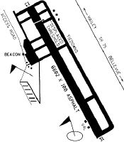
Runways
Runway Summary
| Runways: | 13/31 |
| Longest Runway: | 13/31 is 7550 ft (2301 m) long |
| Runways with an Instrument Approach: |
SUN Airport Runway Details
| Runway 13/31 | 7550 ft x 100 ft (2301 m x 30 m) | |
| Runway Length Source: | 3RD PARTY SURVEY as of 06/18/2013 | |
| Surface: | Asphalt - Good condition - Saw-cut or plastic grooved | |
| Runway Pavement Class: | 23 /F/A/X/T | |
| Runway Edge Lights: | High Intensity | |
Runway Weight Bearing Capacity (in thousands of pounds) |
||
| Single Wheel Landing Gear: | 65.0 | |
| Dual Wheel Landing Gear: | 95.0 | |
| Dual Tandem Wheel Landing Gear: | 150.0 | |
Runway 13 |
Runway 31 |
|
Elevation: |
5319.5 | 5261.8 |
Latitude: |
43-30-44.0640N | 43-29-43.1605N |
Longitude: |
114-18-13.5435W | 114-17-14.4838W |
|
Runway True Alignment: |
145 | 325 |
Glide Path Angle: |
0.0 degrees | 3.5 degrees |
Traffic Pattern: |
Left | Left |
Runway Markings Type: |
Nonprecision Instrument | Precision Instrument |
Runway Markings Condition: |
Good | Fair |
Object at End: |
ROAD | TREE |
Object Height: |
17 | 64 |
Object Marked/Lighted?: |
Lighted | |
Distance from End: |
200 | 1600 |
Object Centerline Offset: |
190 ft. left of centerline | 600 ft. left of centerline |
Visual Glide Slope Indicators: |
4-Light PAPI On Left Side Of Runway | |
Threshold Crossing Height: |
55 | |
Threshold Elevation: |
5308.6 | |
Displaced Threshold: |
1701 | |
Threshold Latitude: |
43-30-30.3430N | |
Threshold Longitude: |
114-18-00.2331W | |
Declared Distances |
||
Take Off Run Avbl. (TORA): |
7550 | 5850 |
Take Off Distance Avbl. (TODA): |
7550 | 7550 |
Actual Stop Dist. Avbl. (ASDA): |
7550 | 6631 |
Landing Dist. Avbl. (LDA): |
5850 | 6631 |
Services
Airframe Repair: |
None |
Powerplant Repair: |
None |
Bottled Oxygen: |
None |
Bulk Oxygen: |
None |
Fuel Available: |
100LL |
Landing Fees: |
No |
Parking: |
Tiedowns available |
Maps & Diagrams
SUN Sectional
Flight Planning
at skyvector.com
at skyvector.com