Location
Latitude: |
40-36-36.3330N (40.610093) |
Longitude: |
083-38-39.3334W (-83.644259) |
Elevation: |
1029.0 feet MSL (314 m MSL) |
Magnetic Variation: |
6.9 W (as of April 2024 from WMM2020 model) |
Time Zone: |
UTC -5.0 (Standard Time) UTC -4.0 (Daylight Savings Time) |
From City: |
03 N.M. SW of Kenton, Ohio |
Found On: |
Detroit Chart |
FAA Region: |
AGL |
Contacts
Manager: |
Publicly owned: |
| ED MCCORMICK 13975 COUNTY ROAD 135 KENTON, OH 43326-9304 419-673-9542 |
HARDIN CO ARPT AUTH 20783 COUNTY ROAD 200 KENTON, OH 43326 567-674-9355 |
Operations
Airport Status: |
Operational |
Facility Use: |
Public |
Type: |
Airport |
Activation Date: |
07/1968 |
Control tower: |
No |
Attendance (Months/Days/Hours): |
Months/Days/Hours ALL/SAT-SUN/0900-1700 |
Boundary ARTCC: |
ZID (Indianapolis) |
Responsible ARTCC: |
ZID (Indianapolis) |
Lighting Schedule: |
SEE RMK |
Segmented Circle Indicator: |
No |
Traffic Pattern Altitude (MSL): |
2029 feet (618 m) |
NOTAMs Facility: |
DAY |
NOTAM-D Service: |
Yes |
International Airport of Entry: |
No |
Customs Landing Rights: |
No |
Military Landing Rights: |
No |
Civil/Military Joint Use: |
No |
Based Aircraft
| Single Engine: | 16 |
Annual Operations (as of 06/22/2022)
| Total Operations: | 7342 | |
| Air Taxi: | 630 | 8.6% |
| GA Local: | 3675 | 50.1% |
| GA Itinerant: | 2985 | 40.7% |
| Military Aircraft: | 52 | 0.7% |
Communications
| CTAF: | 122.800 |
| Unicom: | 122.800 |
| Approach: | COLUMBUS 118.425 118.425 |
| Departure: | COLUMBUS 118.425 118.425 |
| AWOS-3: | 126.4 (419-675-0781) |
Fixed Based Operators (FBOs) & Fuel
(Click on a business for detail)
Please help us keep this information up to date. This is a FREE SERVICE just like everything else on Airport Guide! If you see that a business needs to be added, modified, or deleted please fill out our Update Form.
To add, modify, or delete a business click here.
Please help us keep this information up to date. This is a FREE SERVICE just like everything else on Airport Guide! If you see that a business needs to be added, modified, or deleted please fill out our Update Form.
Area Code: 419 |
| Business Name | Frequency | Phone | Fuel Grade |
|---|
Flight Service Stations
| Primary | Alternate | |
| FSS on Field: | N | |
| FSS Name (ID): | Dayton(DAY) | |
| Frequency: | ||
| Toll Free Phone: | 1-800-WX-BRIEF |
Instrument Procedures / Charts
FAA Terminal Procedures valid from 0901Z 03/21/24 to 0901Z 04/18/24.
There are various types of charts available for an airport. They are listed in the Page Type column. Here is a legend for those types:
APD - Airport Diagram
DP - Departure Procedure Charts
HOT - Hot Spots
IAP - Instrument Approach Procedure Charts
MIN - Minimums
STAR - Standard Terminal Arrival Charts
| Page Type | Page Name | Volume | Action Since Last Cycle |
|---|---|---|---|
| IAP | RNAV (GPS) RWY 04 | EC-2 | |
| IAP | RNAV (GPS) RWY 22 | EC-2 | |
| MIN | TAKEOFF MINIMUMS | EC-2 |
Terminal Procedures are only available for airports in several countries with more being added all the time. If you are looking for a specific country's charts, please send an email to support(at)airportguide.com stating the country name. This will be used to prioritize the implementation.
Navigation Aids (Navaids) near I95
| Dist (NM) | ID | Morse Code | Name | Type | Freq | True Hdg | Mag Hdg |
|---|---|---|---|---|---|---|---|
| 9.1 | RUV | . _ . . . _ . . . _ | Rushsylvania | NDB | 326 | 186 | 193 |
| 15.9 | AOH | . _ _ _ _ . . . . | Allen County | VOR | 108.40 | 291 | 298 |
| 21.3 | FBC | . . _ . _ . . . _ . _ . | Flag City | VORTAC | 108.20 | 346 | 353 |
| 24.7 | BNR | _ . . . _ . . _ . | Benton Ridge | NDB | 334 | 357 | 364 |
| 26.4 | BUD | _ . . . . . _ _ . . | Buckeye | VOR | 109.80 | 88 | 95 |
| 26.6 | ROD | . _ . _ _ _ _ . . | Rosewood | VORTAC | 117.50 | 223 | 230 |
| 35.0 | TII | _ . . . . | Tiffin | NDB | 269 | 33 | 40 |
| 36.5 | FZI | . . _ . _ _ . . . . | Fostoria | NDB | 379 | 17 | 24 |
| 38.1 | OS | _ _ _ . . . | Fuler | NDB | 515 | 147 | 154 |
| 42.6 | CQA | _ . _ . _ _ . _ . _ | Lakefield | NDB | 205 | 259 | 266 |
| 44.6 | CCJ | _ . _ . _ . _ . . _ _ _ | Clark County | NDB | 341 | 188 | 195 |
| 45.7 | CHC | _ . _ . . . . . _ . _ . | Grens | NDB | 272 | 141 | 148 |
| 46.6 | VFU | . . . _ . . _ . . . _ | Stanley | NDB | 411 | 289 | 296 |
| 47.2 | XSF | _ . . _ . . . . . _ . | Springfield | TACAN | 133.80 | 191 | 198 |
| 47.3 | SGH | . . . _ _ . . . . . | Springfield | DME | 113.2 | 191 | 198 |
| 49.5 | DQN | _ . . _ _ . _ _ . | Dayton | VOR-DME | 114.50 | 224 | 231 |
| 50.1 | DAY | _ . . . _ _ . _ _ | Dayton J M Cox-Day | VOT | 111.00 | 211 | 218 |
| 50.3 | MFD | _ _ . . _ . _ . . | Mansfield | VORTAC | 108.80 | 71 | 78 |
| 50.5 | VWV | . . . _ . _ _ . . . _ | Waterville | VOR-DME | 113.10 | 0 | 7 |
| 50.7 | CMH | _ . _ . _ _ . . . . | Port Columbus | VOT | 111.00 | 136 | 143 |
Nearby Airports with Fuel
Notices to Airmen (NOTAMS)
Remarks
| A110-1 | DEER & BIRDS ON & INVOF ARPT. |
| A110-2 | FOR CD CTC COLUMBUS APCH AT 614-338-8537. |
| A17 | UNATNDD MAJOR HOLS. |
| A58-22 | 30 FT TWY, 0-200 FT DIST, 220-250 FT R. |
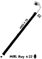
| A81-APT | ACTVT MIRL RWY 04/22 - 3 CLICKS CTAF WI 3 SECS. |
| E111 | VFR USE ONLY. |
Runways
Runway Summary
| Runways: | 04/22 |
| Longest Runway: | 04/22 is 4797 ft (1462 m) long |
| Runways with an Instrument Approach: |
I95 Airport Runway Details
| Runway 04/22 | 4797 ft x 75 ft (1462 m x 23 m) | |
| Runway Length Source: | 3RD PARTY SURVEY as of 12/10/2017 | |
| Surface: | Asphalt - Good condition - No special surface treatment | |
| Runway Edge Lights: | Medium Intensity | |
Runway Weight Bearing Capacity (in thousands of pounds) |
||
| Single Wheel Landing Gear: | 19.0 | |
Runway 04 |
Runway 22 |
|
Elevation: |
1029.0 | 1003.6 |
Latitude: |
40-36-18.0885N | 40-36-54.5769N |
Longitude: |
083-38-59.1766W | 083-38-19.4875W |
|
Runway True Alignment: |
040 | 220 |
Glide Path Angle: |
0.0 degrees | 0.0 degrees |
Traffic Pattern: |
Right | Left |
Runway Markings Type: |
Nonprecision Instrument | Nonprecision Instrument |
Runway Markings Condition: |
Good | Good |
Object at End: |
TREE | ACFT |
Object Height: |
93 | 30 |
Distance from End: |
1862 | 201 |
Object Centerline Offset: |
316 ft. right of centerline | 220 ft. right of centerline |
REIL: |
No | No |
Services
Fuel Available: |
100LL, Jet A |
Landing Fees: |
No |
Parking: |
Hangars and tiedowns available |
Maps & Diagrams
I95 Sectional
Flight Planning
at skyvector.com
at skyvector.com