
Location
Latitude: |
42-57-55.6700N (42.965464) |
Longitude: |
083-44-41.0570W (-83.744738) |
Elevation: |
782.1 feet MSL (238 m MSL) |
Magnetic Variation: |
7.1 W (as of March 2025 from WMM2020 model) |
Time Zone: |
UTC -5.0 (Standard Time) UTC -4.0 (Daylight Savings Time) |
From City: |
03 N.M. SW of Flint, Michigan |
Found On: |
Detroit Chart |
FAA Region: |
AGL |
Contacts
Manager: |
Publicly owned: |
| NINO SAPONE G-3425 W BRISTOL RD FLINT, MI 48507 810-235-6560 |
BISHOP INTL ARPT AUTH G-3425 W BRISTOL RD FLINT, MI 48507 810-235-6560 |
Operations
Airport Status: |
Operational |
Facility Use: |
Public |
Type: |
Airport |
Activation Date: |
04/1940 |
Control tower: |
Yes |
Attendance (Months/Days/Hours): |
Months/Days/Hours ALL/ALL/ALL |
Boundary ARTCC: |
ZOB (Cleveland) |
Responsible ARTCC: |
ZOB (Cleveland) |
Lighting Schedule: |
SEE RMK |
Segmented Circle Indicator: |
Yes |
Traffic Pattern Altitude (MSL): |
1782 feet (543 m) |
NOTAMs Facility: |
FNT |
NOTAM-D Service: |
Yes |
International Airport of Entry: |
No |
Customs Landing Rights: |
Yes |
Military Landing Rights: |
Yes |
Civil/Military Joint Use: |
No |
Aircraft Rescue and Firefighting: |
Class I ARFF Index: B Air Carrier Service: Scheduled Certification Date: 05/1973 |
Based Aircraft
Annual Operations (as of )
Communications
| CTAF: | 126.300 |
| Unicom: | 122.950 |
| Tower: | FLINT 126.3 257.9 Hrs: 0545-2330 |
| Clearance Del.: | 121.75 |
| Ground: | 121.9 |
| Approach: | GREAT LAKES 118.8 118.8 118.8 118.8 118.8 118.8 CLEVELAND ARTCC |
| Departure: | GREAT LAKES 118.8 118.8 118.8 118.8 118.8 118.8 CLEVELAND ARTCC |
| ATIS: | 133.15 Hrs: 24 |
| ASOS: | (810-342-7804) |
- EMERG FREQS NOT AVBL AT TWR.
- APCH/DEP SVC PRVDD BY CLEVELAND ARTCC (ZOB) ON FREQS 126.75/348.75 (FLINT RCAG) WHEN GREAT LAKES APCH CTL CLSD.
Fixed Based Operators (FBOs) & Fuel
(Click on a business for detail)
Please help us keep this information up to date. This is a FREE SERVICE just like everything else on Airport Guide! If you see that a business needs to be added, modified, or deleted please fill out our Update Form.
To add, modify, or delete a business click here.
Please help us keep this information up to date. This is a FREE SERVICE just like everything else on Airport Guide! If you see that a business needs to be added, modified, or deleted please fill out our Update Form.
Area Code: 810 |
| Business Name | Frequency | Phone | Fuel Grade |
|---|---|---|---|
| AvFlight Flint
Website Update FBO info |
Unicom 122.95 | 844.FUEL.FNT (844.383.5882) | 100LL, Jet A |

|
 Avfuel |
100LL - 8.02 USD per gallon on 06/20/2022 |
48507 self service |
|
|
Avfuel |
100LL - 8.27 USD per gallon on 06/20/2022 |
48507 Full Service Retail |
|
|
Avfuel |
Jet A - 8.50 USD per gallon on 07/12/2022 |
48507 AVFUEL CONTRACT/ AVTRIP POINTS WITH FUEL PURCHASE |
|
|
Avfuel |
Jet A+ - 8.64 USD per gallon on 07/12/2022 |
48507 AVFUEL CONTRACT/ AVTRIP POINTS WITH FUEL PURCHASE |
| Gourmet Airfare
Website Update FBO info |
866-JET-FOOD (538-3663) |
Flight Service Stations
| Primary | Alternate | |
| FSS on Field: | N | |
| FSS Name (ID): | Lansing(LAN) | |
| Frequency: | ||
| Toll Free Phone: | 1-800-WX-BRIEF |
Instrument Procedures / Charts
FAA Terminal Procedures valid from 0901Z 03/20/25 to 0901Z 04/17/25.
There are various types of charts available for an airport. They are listed in the Page Type column. Here is a legend for those types:
APD - Airport Diagram
DP - Departure Procedure Charts
HOT - Hot Spots
IAP - Instrument Approach Procedure Charts
MIN - Minimums
STAR - Standard Terminal Arrival Charts
Terminal Procedures are only available for airports in several countries with more being added all the time. If you are looking for a specific country's charts, please send an email to support(at)airportguide.com stating the country name. This will be used to prioritize the implementation.
Navigation Aids (Navaids) near FNT
Navigational Aid (NAVAID) distances from the airport are listed in Nautical Miles (NM).
Nearby Airports with Fuel
Notices to Airmen (NOTAMS)
Remarks
| A110-2 | BIRDS & DEER ON & INVOF ARPT. |
| A110-3 | FOR CD WHEN ATCT CLSD CTC GREAT LAKES APCH AT 269-459-3345, WHEN APCH CLSD CTC CLEVELAND ARTCC AT 440-774-0224/0490. |
| A43-18 | PAPI UNUSBL BYD 8 DEGS LEFT OF CNTRLN. |
| A57-18 | APCH RATIO 28:1 TO DTHR. |
| A70-FUEL-10 | 0LL 100LL AVBL SELF SVC AT GOLF TEES. |
| A81-APT | WHEN ATCT CLSD ACTVT MALSR RWY 09 & 27; REIL RWY 18 & 36; HIRL RWY 09/27 & 18/36 - CTAF. |
Runways
Runway Summary
| Runways: | 09/27 18/36 |
| Longest Runway: | 18/36 is 7852 ft (2393 m) long |
| Runways with an Instrument Approach: | 09, 27 |
FNT Airport Runway Details
| Runway 09/27 | 7201 ft x 150 ft (2195 m x 46 m) | |
| Runway Length Source: | 3RD PARTY SURVEY as of 04/15/2022 | |
| Surface: | Asphalt - Good condition - Saw-cut or plastic grooved | |
| Runway Pavement Class: | 88 /F/A/W/T | |
| Runway Edge Lights: | High Intensity | |
Runway Weight Bearing Capacity (in thousands of pounds) |
||
| Single Wheel Landing Gear: | 120.0 | |
| Dual Wheel Landing Gear: | 250.0 | |
| Dual Tandem Wheel Landing Gear: | 550.0 | |
Runway 09 |
Runway 27 |
|
Elevation: |
763.8 | 762.5 |
Latitude: |
42-58-08.3106N | 42-58-10.4769N |
Longitude: |
083-45-35.3714W | 083-43-58.5638W |
|
Runway True Alignment: |
088 | 268 |
ILS Type: |
ILS | ILS |
Glide Path Angle: |
3.0 degrees | 3.0 degrees |
Traffic Pattern: |
Left | Left |
Runway Markings Type: |
Precision Instrument | Precision Instrument |
Runway Markings Condition: |
Good | Good |
Object at End: |
TREES | TREES |
Object Height: |
60 | 76 |
Distance from End: |
2460 | 2968 |
Object Centerline Offset: |
540 ft. left of centerline | 98 ft. right of centerline |
Visual Glide Slope Indicators: |
4-Light PAPI On Right Side Of Runway | 4-Light PAPI On Left Side Of Runway |
Runway Visual Range (RVR): |
Touchdown | Rollout |
Approach Light System: |
1,400 Foot Medium Intensity Approach Lighting System With Runway Alignment Indicator Lights | 1,400 Foot Medium Intensity Approach Lighting System With Runway Alignment Indicator Lights |
REIL: |
No | No |
Touchdown Lights: |
No | No |
Centerline Lights: |
No | No |
Threshold Crossing Height: |
63 | 56 |
Declared Distances |
||
Take Off Run Avbl. (TORA): |
7201 | 7201 |
Take Off Distance Avbl. (TODA): |
7201 | 7201 |
Actual Stop Dist. Avbl. (ASDA): |
7201 | 7201 |
Landing Dist. Avbl. (LDA): |
7201 | 7201 |
| Runway 18/36 | 7852 ft x 150 ft (2393 m x 46 m) | |
| Runway Length Source: | 3RD PARTY SURVEY as of 04/15/2022 | |
| Surface: | Asphalt - Good condition - Saw-cut or plastic grooved | |
| Runway Pavement Class: | 88 /F/A/W/T | |
| Runway Edge Lights: | High Intensity | |
Runway Weight Bearing Capacity (in thousands of pounds) |
||
| Single Wheel Landing Gear: | 120.0 | |
| Dual Wheel Landing Gear: | 250.0 | |
| Dual Tandem Wheel Landing Gear: | 550.0 | |
Runway 18 |
Runway 36 |
|
Elevation: |
763.9 | 779.0 |
Latitude: |
42-58-21.8502N | 42-57-04.3093N |
Longitude: |
083-44-36.4428W | 083-44-34.8319W |
|
Runway True Alignment: |
179 | 359 |
Glide Path Angle: |
3.0 degrees | 3.0 degrees |
Traffic Pattern: |
Left | Left |
Runway Markings Type: |
Nonprecision Instrument | Nonprecision Instrument |
Runway Markings Condition: |
Good | Good |
Object at End: |
TREE | TREE |
Object Height: |
79 | 69 |
Distance from End: |
2229 | 1945 |
Object Centerline Offset: |
540 ft. left of centerline | 98 ft. right of centerline |
Visual Glide Slope Indicators: |
4-Light PAPI On Right Side Of Runway | 4-Light PAPI On Left Side Of Runway |
REIL: |
Yes | Yes |
Touchdown Lights: |
No | No |
Centerline Lights: |
No | No |
Threshold Crossing Height: |
47 | 55 |
Threshold Elevation: |
764.9 | |
Displaced Threshold: |
202 | |
Threshold Latitude: |
42-58-19.8580N | |
Threshold Longitude: |
083-44-36.4010W | |
Declared Distances |
||
Take Off Run Avbl. (TORA): |
7852 | 7852 |
Take Off Distance Avbl. (TODA): |
7852 | 7852 |
Actual Stop Dist. Avbl. (ASDA): |
7852 | 7652 |
Landing Dist. Avbl. (LDA): |
7650 | 7652 |
Services
Airframe Repair: |
None |
Powerplant Repair: |
None |
Bottled Oxygen: |
None |
Bulk Oxygen: |
None |
Fuel Available: |
100LL, Jet A+ |
Landing Fees: |
No |
Parking: |
Hangars and tiedowns available |
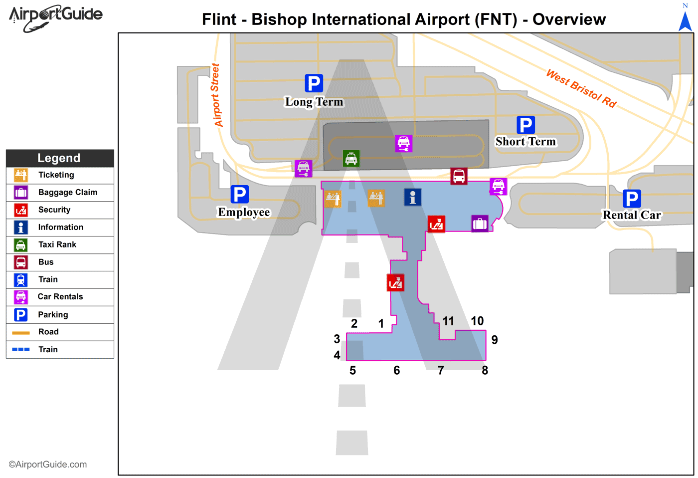
Maps & Diagrams
FNT Sectional
Flight Planning
at skyvector.com
at skyvector.com
