Location
Latitude: |
45-03-53.0000N (45.064722) |
Longitude: |
117-39-41.6800W (-117.661578) |
Elevation: |
3400.0 feet MSL (1036 m MSL) |
Magnetic Variation: |
13.6 E (as of May 2024 from WMM2020 model) |
Time Zone: |
UTC -8.0 (Standard Time) UTC -7.0 (Daylight Savings Time) |
From City: |
15 N.M. N of Union, Oregon |
Found On: |
Seattle Chart |
FAA Region: |
ANM |
Contacts
Manager: |
Privately owned: |
| STEFANO F. TOGNOLI 53078 HWY 203 UNION, OR 97883 360-901-3660 |
STEFANO F. TOGNOLI 53078 HWY 203 UNION, OR 97883 360-901-3660 |
Operations
Airport Status: |
Operational |
Facility Use: |
Private |
Type: |
Airport |
Activation Date: |
08/2012 |
Control tower: |
No |
Attendance (Months/Days/Hours): |
Months/Days/Hours Unattended |
Boundary ARTCC: |
ZSE (Seattle) |
Responsible ARTCC: |
ZLC (Salt Lake City) |
Traffic Pattern Altitude (MSL): |
4400 feet (1341 m) |
Based Aircraft
| Single Engine: | 1 |
Annual Operations (as of )
Communications
Fixed Based Operators (FBOs) & Fuel
(Click on a business for detail)
Please help us keep this information up to date. This is a FREE SERVICE just like everything else on Airport Guide! If you see that a business needs to be added, modified, or deleted please fill out our Update Form.
To add, modify, or delete a business click here.
Please help us keep this information up to date. This is a FREE SERVICE just like everything else on Airport Guide! If you see that a business needs to be added, modified, or deleted please fill out our Update Form.
| Business Name | Frequency | Phone | Fuel Grade |
|---|
Flight Service Stations
| Primary | Alternate | |
| FSS on Field: | ||
| FSS Name (ID): | Mc Minnville(MMV) | |
| Frequency: | ||
| Toll Free Phone: | 1-800-WX-BRIEF |
Instrument Procedures / Charts
Terminal Procedures are only available for airports in several countries with more being added all the time. If you are looking for a specific country's charts, please send an email to support(at)airportguide.com stating the country name. This will be used to prioritize the implementation.
Navigation Aids (Navaids) near OR03
| Dist (NM) | ID | Morse Code | Name | Type | Freq | True Hdg | Mag Hdg |
|---|---|---|---|---|---|---|---|
| 14.8 | BKE | _ . . . _ . _ . | Baker City | VOR-DME | 115.30 | 204 | 190 |
| 21.0 | LGD | . _ . . _ _ . _ . . | La Grande | NDB | 296 | 322 | 308 |
| 58.8 | PD | . _ _ . _ . . | Foris | NDB | 230 | 310 | 296 |
| 64.4 | DNJ | _ . . _ . . _ _ _ | Donnelly | VOR-DME | 116.20 | 105 | 92 |
| 65.9 | PDT | . _ _ . _ . . _ | Pendleton | VORTAC | 114.70 | 305 | 291 |
| 66.8 | ALW | . _ . _ . . . _ _ | Walla Walla | VOR-DME | 116.40 | 336 | 322 |
| 68.6 | ONO | _ _ _ _ . _ _ _ | Ontario | NDB | 305 | 155 | 142 |
| 70.3 | AL | . _ . _ . . | Trina | NDB | 353 | 341 | 327 |
| 78.3 | IDQ | . . _ . . _ _ . _ | Cottonwood | DME | 115.65 | 39 | 26 |
| 85.7 | MQG | _ _ _ _ . _ _ _ . | Nez Perce | VOR-DME | 114.45 | 22 | 8 |
| 90.7 | IMB | . . _ _ _ . . . | Kimberly | VOR-DME | 115.60 | 254 | 240 |
| 94.6 | PSC | . _ _ . . . . _ . _ . | Pasco | VOR-DME | 113.75 | 320 | 306 |
| 98.3 | PUW | . _ _ . . . _ . _ _ | Pullman | VOR-DME | 117.15 | 10 | 356 |
Nearby Airports with Fuel
Notices to Airmen (NOTAMS)
Remarks
| A110-1 | FOR CD CTC SALT LAKE ARTCC AT 801-320-2568. |
| E111 | PRVDD VFR OPNS AND PVT USE ONLY. |
Runways
Runway Summary
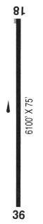
| Runways: | 16/34 |
| Longest Runway: | 16/34 is 1500 ft (457 m) long |
| Runways with an Instrument Approach: |
OR03 Airport Runway Details
| Runway 16/34 | 1500 ft x 150 ft (457 m x 46 m) | |
| Runway Length Source: | OWNER as of 05/13/2011 | |
| Surface: | Turf - No special surface treatment | |
Runway 16 |
Runway 34 |
|
Glide Path Angle: |
0.0 degrees | 0.0 degrees |
Services
Airframe Repair: |
None |
Powerplant Repair: |
None |
Bottled Oxygen: |
None |
Bulk Oxygen: |
None |
Fuel Available: |
100LL |
Landing Fees: |
No |
Parking: |
Tiedowns available |
Maps & Diagrams
OR03 Sectional
Flight Planning
at skyvector.com
at skyvector.com