Location
Latitude: |
29-59-35.8000N (29.993278) |
Longitude: |
090-15-32.5000W (-90.259028) |
Elevation: |
3.7 feet MSL (1 m MSL) |
Magnetic Variation: |
1.3 W (as of April 2024 from WMM2020 model) |
Time Zone: |
UTC -6.0 (Standard Time) UTC -5.0 (Daylight Savings Time) |
From City: |
10 N.M. W of New Orleans, Louisiana |
Found On: |
New Orleans Chart |
FAA Region: |
ASW |
Contacts
Manager: |
Publicly owned: |
| KEVIN DOLLIOLE PO BOX 20007 NEW ORLEANS, LA 70141 (504) 303-7652 |
CITY OF NEW ORLEANS PO BOX 20007 NEW ORLEANS, LA 70141 504-658-4900 |
Operations
Airport Status: |
Operational |
Facility Use: |
Public |
Type: |
Airport |
Activation Date: |
10/1944 |
Control tower: |
Yes |
Attendance (Months/Days/Hours): |
Months/Days/Hours ALL/ALL/ALL |
Boundary ARTCC: |
ZHU (Houston) |
Responsible ARTCC: |
ZHU (Houston) |
Lighting Schedule: |
SS-SR |
Segmented Circle Indicator: |
No |
Traffic Pattern Altitude (MSL): |
1004 feet (306 m) |
NOTAMs Facility: |
MSY |
NOTAM-D Service: |
Yes |
International Airport of Entry: |
No |
Customs Landing Rights: |
Yes |
Military Landing Rights: |
Yes |
Civil/Military Joint Use: |
No |
Aircraft Rescue and Firefighting: |
Class I ARFF Index: D Air Carrier Service: Scheduled Certification Date: 05/1973 |
Based Aircraft
| Single Engine: | 2 |
| Multi Engine: | 2 |
| Jet Engine: | 13 |
| GA Helicopters: | 7 |
Annual Operations (as of 02/28/2022)
| Total Operations: | 102416 | |
| Commercial: | 85205 | 83.2% |
| Air Taxi: | 7375 | 7.2% |
| GA Itinerant: | 9322 | 9.1% |
| Military Aircraft: | 514 | 0.5% |
Communications
| Unicom: | 122.950 |
| Tower: | NEW ORLEANS 119.5 254.3 Hrs: 24 |
| Clearance Del.: | 120.925 |
| Ground: | 121.9 273.525 |
| Approach: | NEW ORLEANS 125.5 ;WEST 133.15 ;EAST 290.3 ;EAST 350.35 ;WEST Hrs: 24 269.2 |
| Departure: | NEW ORLEANS 125.5 ;WEST 133.15 ;EAST 290.3 ;EAST 350.35 ;WEST Hrs: 24 269.2 |
| ATIS: | 127.55 Hrs: 24 |
| ASOS: | ((504)471-4486) |
| OLEDD STAR: | 125.5 ;WEST |
| MNSTR STAR: | 290.3 ;EAST |
| EMERG: | 121.5 |
| MNSTR STAR: | 133.15 ;EAST |
| CLASS B: | 290.3 ;NORTH & EAST |
| CLASS B: | 133.15 ;NORTH & EAST |
| CLASS B: | 123.85 ;SE & SOUTH |
| EMERG: | 243.0 |
| AWDAD STAR: | 350.35 ;WEST |
| CLASS B: | 350.35 ;WEST |
| AWDAD STAR: | 125.5 ;WEST |
| CLASS B: | 256.9 ;SE & SOUTH |
| OLEDD STAR: | 350.35 ;WEST |
| CLASS B: | 125.5 ;WEST |
Fixed Based Operators (FBOs) & Fuel
(Click on a business for detail)
Please help us keep this information up to date. This is a FREE SERVICE just like everything else on Airport Guide! If you see that a business needs to be added, modified, or deleted please fill out our Update Form.
To add, modify, or delete a business click here.
Please help us keep this information up to date. This is a FREE SERVICE just like everything else on Airport Guide! If you see that a business needs to be added, modified, or deleted please fill out our Update Form.
Area Code: 504 |
| Business Name | Frequency | Phone | Fuel Grade |
|---|---|---|---|
| General Aviation Corp.
Update FBO info |
Unicom 122.95, Arinc 130.375 | 466-1700 | 100LL (Exxon, Independent), Jet A (Exxon, Shell, Independent) |
| Signature Flight Support
Update FBO info |
Unicom: 122.95, Arinc: 130.6 | +1 504 468 7722 | |
| Transit Aviation, Inc.
Update FBO info |
Unicom 122.95 | 468-7722 | 100LL (Air BP), Jet A (Exxon, Shell, Air Bp, Mercury) |
Flight Service Stations
| Primary | Alternate | |
| FSS on Field: | N | |
| FSS Name (ID): | De Ridder(DRI) | |
| Frequency: | ||
| Toll Free Phone: | 1-800-WX-BRIEF |
Instrument Procedures / Charts
FAA Terminal Procedures valid from 0901Z 03/21/24 to 0901Z 04/18/24.
There are various types of charts available for an airport. They are listed in the Page Type column. Here is a legend for those types:
APD - Airport Diagram
DP - Departure Procedure Charts
HOT - Hot Spots
IAP - Instrument Approach Procedure Charts
MIN - Minimums
STAR - Standard Terminal Arrival Charts
| Page Type | Page Name | Volume | Action Since Last Cycle |
|---|---|---|---|
| APD | AIRPORT DIAGRAM | SC-4 | Changed |
| HOT | HOT SPOT | SC-4 | |
| IAP | ILS OR LOC RWY 02 | SC-4 | |
| IAP | ILS OR LOC RWY 11 | SC-4 | |
| IAP | ILS OR LOC RWY 29 | SC-4 | |
| IAP | ILS RWY 11 (CAT II - III) | SC-4 | |
| IAP | ILS RWY 11 (SA CAT I) | SC-4 | |
| IAP | LOC RWY 20 | SC-4 | |
| IAP | RNAV (GPS) RWY 02 | SC-4 | |
| IAP | RNAV (GPS) Y RWY 11 | SC-4 | |
| IAP | RNAV (GPS) Y RWY 20 | SC-4 | |
| IAP | RNAV (GPS) Y RWY 29 | SC-4 | |
| IAP | RNAV (RNP) Z RWY 11 | SC-4 | |
| IAP | RNAV (RNP) Z RWY 20 | SC-4 | |
| IAP | RNAV (RNP) Z RWY 29 | SC-4 | |
| IAP | VOR/DME RWY 11 | SC-4 | |
| MIN | ALTERNATE MINIMUMS | SC-4 | |
| MIN | TAKEOFF MINIMUMS | SC-4 | |
| STAR | AWDAD ONE | SC-4 | |
| STAR | MNSTR ONE (RNAV) | SC-4 | |
| STAR | OLEDD FOUR | SC-4 | |
| STAR | TRSSH ONE (RNAV) | SC-4 |
Terminal Procedures are only available for airports in several countries with more being added all the time. If you are looking for a specific country's charts, please send an email to support(at)airportguide.com stating the country name. This will be used to prioritize the implementation.
Navigation Aids (Navaids) near MSY
| Dist (NM) | ID | Morse Code | Name | Type | Freq | True Hdg | Mag Hdg |
|---|---|---|---|---|---|---|---|
| 7.6 | MS | _ _ . . . | Kinte | NDB | 338 | 284 | 285 |
| 15.8 | HRV | . . . . . _ . . . . _ | Harvey | VORTAC | 114.10 | 122 | 123 |
| 18.0 | RQR | . _ . _ _ . _ . _ . | Reserve | VOR-DME | 110.80 | 288 | 289 |
| 32.6 | HMU | . . . . _ _ . . _ | Hammond | VOR | 109.60 | 345 | 346 |
| 35.6 | TBD | _ _ . . . _ . . | Tibby | VOR-DME | 112.00 | 236 | 237 |
| 37.7 | HP | . . . . . _ _ . | Anger | NDB | 212 | 347 | 348 |
| 43.7 | PCU | . _ _ . _ . _ . . . _ | Picayune | VOR-DME | 113.95 | 38 | 40 |
| 49.7 | LEV | . _ . . . . . . _ | Leeville | VORTAC | 113.50 | 170 | 171 |
| 49.9 | HS | . . . . . . . | Hanco | NDB | 221 | 56 | 58 |
| 57.1 | GVB | _ _ . . . . _ _ . . . | Bogalusa | NDB | 353 | 20 | 21 |
| 58.5 | PTN | . _ _ . _ _ . | Patterson | NDB | 245 | 253 | 254 |
| 60.7 | BT | _ . . . _ | Rundi | NDB | 284 | 305 | 306 |
| 61.2 | LSU | . _ . . . . . . . _ | Fighting Tiger | VORTAC | 116.50 | 299 | 300 |
| 64.1 | GP | _ _ . . _ _ . | Bayou | NDB | 360 | 62 | 64 |
| 66.1 | GPT | _ _ . . _ _ . _ | Gulfport | VORTAC | 109.00 | 67 | 69 |
| 73.3 | BIX | _ . . . . . _ . . _ | Keesler | TACAN | 111.80 | 69 | 71 |
| 74.4 | FWX | . . _ . . _ _ _ . . _ | New Roads | NDB | 356 | 301 | 302 |
| 76.8 | MC | _ _ _ . _ . | Ferni | NDB | 413 | 350 | 351 |
| 78.7 | MCB | _ _ _ . _ . _ . . . | Mc Comb | VORTAC | 116.70 | 0 | 1 |
| 83.4 | AR | . _ . _ . | Acadi | NDB | 269 | 268 | 269 |
Nearby Airports with Fuel
Notices to Airmen (NOTAMS)
Remarks
| A110-1 | 180 DEG & LOCKED WHEEL TURNS PROHIBITED ON ASPH SFC ACFT 12500 LBS & OVER. |
| A110-3 | FLOCKS OF BIRDS ON & IN VICINITY OF ARPT. |
| A110-5 | RY 11 NOISE SENSITIVE FOR DEP; AVBL FOR OPNL NECESSITY. ALL RYS NOISE SENSITIVE FOR ARR. ARRIVING TURBOJETS MUST MAKE 5 MILE FINAL APCH TO MINIMIZE NOISE. |
| A110-6 | ASSC IN USE. OPERATE TRANSPONDERS WITH ALTITUDE REPORTING MODE AND ADS-B (IF EQUIPPED) ENABLED ON ALL AIRPORT SURFACES. |
| A110-7 | TWY G BTN RWY 11/29 AND TWY S SFC MOV GUIDANCE AND CTL SYSTEM U/S PERM |
| A57-29 | +53 FT TREE, 1557 FT DIST, 694 FT R, 30:1 BASED ON DSPLCD THLD. |
| A58-02 | +12 FT ROAD PARALLEL TO AND 365 FT RIGHT OF CNTRLN 0-200 FT FM RY END. |
| A58-20 | +13 FT ROAD PARALLEL TO AND 289 FT LEFT OF CNTRLN 0-200 FT FM RY END. |
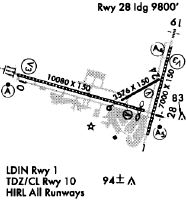
Runways
Runway Summary
| Runways: | 02/20 11/29 |
| Longest Runway: | 11/29 is 10104 ft (3080 m) long |
| Runways with an Instrument Approach: | 02, 20, 11, 29 |
MSY Airport Runway Details
| Runway 02/20 | 7001 ft x 150 ft (2134 m x 46 m) | |
| Runway Length Source: | 3RD PARTY SURVEY as of 07/08/2010 | |
| Surface: | Concrete - Good condition - Saw-cut or plastic grooved | |
| Runway Pavement Class: | 64 /R/C/W/T | |
| Runway Edge Lights: | High Intensity | |
Runway Weight Bearing Capacity (in thousands of pounds) |
||
| Single Wheel Landing Gear: | 75.0 | |
| Dual Wheel Landing Gear: | 180.0 | |
| Dual Tandem Wheel Landing Gear: | 380.0 | |
Runway 02 |
Runway 20 |
|
Elevation: |
1.8 | -2.4 |
Latitude: |
29-59-04.2055N | 30-00-10.9924N |
Longitude: |
090-15-05.0940W | 090-14-43.8363W |
|
Runway True Alignment: |
015 | 195 |
ILS Type: |
ILS/DME | LOC/DME |
Glide Path Angle: |
3.0 degrees | 3.0 degrees |
Traffic Pattern: |
Left | Left |
Runway Markings Type: |
Precision Instrument | Precision Instrument |
Runway Markings Condition: |
Good | Good |
Object at End: |
ROAD | ROAD |
Object Height: |
12 | 13 |
Object Marked/Lighted?: |
Lighted | Lighted |
Distance from End: |
200 | 200 |
Object Centerline Offset: |
365 ft. right of centerline | 289 ft. left of centerline |
Visual Glide Slope Indicators: |
4-Light PAPI On Left Side Of Runway | 4-Light PAPI On Left Side Of Runway |
Runway Visual Range (RVR): |
Touchdown, Rollout | Touchdown, Rollout |
Approach Light System: |
1,400 Foot Medium Intensity Approach Lighting System | |
Touchdown Lights: |
No | No |
Centerline Lights: |
Yes | Yes |
Threshold Crossing Height: |
52 | 52 |
Declared Distances |
||
Take Off Run Avbl. (TORA): |
7001 | 7001 |
Take Off Distance Avbl. (TODA): |
7001 | 7001 |
Actual Stop Dist. Avbl. (ASDA): |
7001 | 7001 |
Landing Dist. Avbl. (LDA): |
7001 | 7001 |
| Runway 11/29 | 10104 ft x 150 ft (3080 m x 46 m) | |
| Runway Length Source: | 3RD PARTY SURVEY as of 07/08/2010 | |
| Surface: | Concrete - Good condition - Saw-cut or plastic grooved | |
| Runway Pavement Class: | 123/R/C/W/T | |
| Runway Edge Lights: | High Intensity | |
Runway Weight Bearing Capacity (in thousands of pounds) |
||
| Single Wheel Landing Gear: | 75.0 | |
| Dual Wheel Landing Gear: | 180.0 | |
| Dual Tandem Wheel Landing Gear: | 380.0 | |
Runway 11 |
Runway 29 |
|
Elevation: |
3.7 | 1.3 |
Latitude: |
29-59-47.8556N | 29-59-21.1654N |
Longitude: |
090-16-54.2241W | 090-15-03.4894W |
|
Runway True Alignment: |
105 | 285 |
ILS Type: |
ILS/DME | ILS/DME |
Glide Path Angle: |
2.8 degrees | 3.0 degrees |
Traffic Pattern: |
Left | Left |
Runway Markings Type: |
Precision Instrument | Precision Instrument |
Runway Markings Condition: |
Good | Good |
Object at End: |
TREE | |
Object Height: |
53 | |
Distance from End: |
1557 | |
Object Centerline Offset: |
365 ft. right of centerline | 289 ft. left of centerline |
Visual Glide Slope Indicators: |
4-Light PAPI On Right Side Of Runway | 4-Light PAPI On Right Side Of Runway |
Runway Visual Range (RVR): |
Touchdown, Midfield, Rollout | Touchdown, Midfield, Rollout |
Approach Light System: |
Standard 2,400 Foot High Intensity Approach Lighting System With Sequenced Flashers, Cat. II or III Config. | 1,400 Foot Medium Intensity Approach Lighting System With Runway Alignment Indicator Lights |
Touchdown Lights: |
Yes | No |
Centerline Lights: |
Yes | Yes |
Threshold Crossing Height: |
55 | 68 |
Threshold Elevation: |
1.4 | |
Displaced Threshold: |
304 | |
Threshold Latitude: |
29-59-21.9691N | |
Threshold Longitude: |
090-15-06.8221W | |
Declared Distances |
||
Take Off Run Avbl. (TORA): |
10104 | 10104 |
Take Off Distance Avbl. (TODA): |
10104 | 10104 |
Actual Stop Dist. Avbl. (ASDA): |
9800 | 10104 |
Landing Dist. Avbl. (LDA): |
9800 | 9800 |
Services
Airframe Repair: |
Major |
Powerplant Repair: |
Major |
Bottled Oxygen: |
High Pressure |
Bulk Oxygen: |
None |
Fuel Available: |
100LL, Jet A |
Landing Fees: |
No |
Parking: |
Hangars and tiedowns available |
Maps & Diagrams
MSY Sectional
Flight Planning
at skyvector.com
at skyvector.com