Location
Latitude: |
33-56-22.9110N (33.939698) |
Longitude: |
096-23-42.2070W (-96.395058) |
Elevation: |
699.1 feet MSL (213 m MSL) |
Magnetic Variation: |
2.4 E (as of April 2024 from WMM2020 model) |
Time Zone: |
UTC -6.0 (Standard Time) UTC -5.0 (Daylight Savings Time) |
From City: |
03 N.M. SW of Durant, Oklahoma |
Found On: |
Dallas-Ft Worth Chart |
FAA Region: |
ASW |
Contacts
Manager: |
Publicly owned: |
| JOSH MATEKOVIC 10 WALDRON DR DURANT, OK 74701 580-579-5024 |
CITY OF DURANT 301 W EVERGREEN DURANT, OK 74701 (580) 920-0574 |
Operations
Airport Status: |
Operational |
Facility Use: |
Public |
Type: |
Airport |
Activation Date: |
09/1943 |
Control tower: |
No |
Attendance (Months/Days/Hours): |
Months/Days/Hours ALL/MON-FRI/0700-1900 |
Boundary ARTCC: |
ZFW (Fort Worth) |
Responsible ARTCC: |
ZFW (Fort Worth) |
Lighting Schedule: |
SEE RMK |
Segmented Circle Indicator: |
Yes |
Traffic Pattern Altitude (MSL): |
1699 feet (518 m) |
NOTAMs Facility: |
DUA |
NOTAM-D Service: |
Yes |
International Airport of Entry: |
No |
Customs Landing Rights: |
No |
Military Landing Rights: |
Yes |
Civil/Military Joint Use: |
No |
Based Aircraft
| Single Engine: | 58 |
| Multi Engine: | 8 |
| Jet Engine: | 5 |
| GA Helicopters: | 2 |
Annual Operations (as of 10/15/2021)
| Total Operations: | 91280 | |
| GA Local: | 73000 | 80.0% |
| GA Itinerant: | 18250 | 20.0% |
| Military Aircraft: | 30 | 0.0% |
Communications
| CTAF: | 123.050 |
| Unicom: | 123.050 |
| AWOS-3: | 124.175 (580-931-3790) |
- APCH/DEP CTL SVC PRVDD BY FORT WORTH ARTCC (ZFW) ON FREQS 124.75/323.0 (GAINESVILLE RCAG).
Fixed Based Operators (FBOs) & Fuel
(Click on a business for detail)
Please help us keep this information up to date. This is a FREE SERVICE just like everything else on Airport Guide! If you see that a business needs to be added, modified, or deleted please fill out our Update Form.
To add, modify, or delete a business click here.
Please help us keep this information up to date. This is a FREE SERVICE just like everything else on Airport Guide! If you see that a business needs to be added, modified, or deleted please fill out our Update Form.
Area Code: 580 |
| Business Name | Frequency | Phone | Fuel Grade |
|---|---|---|---|
| Wings Sales, Rawlings Aviation
Update FBO info |
Unicom 122.8 | 920-0547 | 100LL, Jet A |
Flight Service Stations
| Primary | Alternate | |
| FSS on Field: | N | |
| FSS Name (ID): | Mc Alester(MLC) | |
| Frequency: | ||
| Toll Free Phone: | 1-800-WX-BRIEF |
Instrument Procedures / Charts
FAA Terminal Procedures valid from 0901Z 03/21/24 to 0901Z 04/18/24.
There are various types of charts available for an airport. They are listed in the Page Type column. Here is a legend for those types:
APD - Airport Diagram
DP - Departure Procedure Charts
HOT - Hot Spots
IAP - Instrument Approach Procedure Charts
MIN - Minimums
STAR - Standard Terminal Arrival Charts
| Page Type | Page Name | Volume | Action Since Last Cycle |
|---|---|---|---|
| IAP | RNAV (GPS) RWY 17 | SC-1 | |
| IAP | RNAV (GPS) RWY 35 | SC-1 | |
| MIN | ALTERNATE MINIMUMS | SC-1 | |
| MIN | TAKEOFF MINIMUMS | SC-1 |
Terminal Procedures are only available for airports in several countries with more being added all the time. If you are looking for a specific country's charts, please send an email to support(at)airportguide.com stating the country name. This will be used to prioritize the implementation.
Navigation Aids (Navaids) near DUA
| Dist (NM) | ID | Morse Code | Name | Type | Freq | True Hdg | Mag Hdg |
|---|---|---|---|---|---|---|---|
| 0.3 | URH | . . _ . _ . . . . . | Texoma | DME | 114.3 | 30 | 28 |
| 15.2 | DNI | _ . . _ . . . | Denison | NDB | 341 | 243 | 241 |
| 25.4 | BYP | _ . . . _ . _ _ . _ _ . | Bonham | VORTAC | 114.60 | 161 | 159 |
| 32.0 | AI | . _ . . | Addmo | NDB | 400 | 303 | 300 |
| 41.7 | ADM | . _ _ . . _ _ | Ardmore | VORTAC | 116.70 | 293 | 290 |
| 41.8 | VLY | . . . _ . _ . . _ . _ _ | Melisa | NDB | 421 | 193 | 191 |
| 43.0 | HHW | . . . . . . . . . _ _ | Hugo | NDB | 323 | 81 | 79 |
| 52.9 | PRX | . _ _ . . _ . _ . . _ | Paris | VOR-DME | 113.60 | 116 | 114 |
| 53.5 | ADH | . _ _ . . . . . . | Ada | VOR-DME | 117.80 | 345 | 343 |
| 54.5 | MII | _ _ . . . . | Caddo Mills | NDB | 316 | 172 | 170 |
| 55.0 | MJF | _ _ . _ _ _ . . _ . | Arvilla | TACAN | 109.60 | 162 | 160 |
| 56.2 | DT | _ . . _ | Pinck | NDB | 257 | 225 | 222 |
| 58.8 | ML | _ _ . _ . . | Wampa | NDB | 344 | 28 | 26 |
| 59.8 | SYW | . . . _ . _ _ . _ _ | Cash | NDB | 428 | 163 | 161 |
| 61.6 | SLR | . . . . _ . . . _ . | Sulphur Springs | DME | 109 | 135 | 133 |
| 62.2 | PVJ | . _ _ . . . . _ . _ _ _ | Pauls Valley | NDB | 384 | 318 | 315 |
| 62.4 | MLC | _ _ . _ . . _ . _ . | Mc Alester | TACAN | 112.00 | 28 | 26 |
| 67.9 | CVE | _ . _ . . . . _ . | Cowboy | VOR-DME | 116.20 | 202 | 199 |
| 68.1 | PQF | . _ _ . _ _ . _ . . _ . | Mesquite | NDB | 248 | 185 | 183 |
| 68.9 | DAL | _ . . . _ . _ . . | Dallas | VOT | 113.30 | 199 | 196 |
Nearby Airports with Fuel
Notices to Airmen (NOTAMS)
Remarks
| A110-4 | 372 FT TWR 2.5 MI N. |
| A110-5 | STUDENT TRNG INVOF ARPT & OVR LAKE TEXOMA. |
| A110-6 | FOR CD CTC FORT WORTH ARTCC AT 817-858-7584. |
| A110-7 | AFT HR - 580-579-5024. |
| A16 | AFT HR - 580-579-5024. |
| A17 | AFT HR ON REQ. |
| A70-FUEL-10 | 0LL AFT HR FUEL - 580-579-5024. |
| A81-APT | ACTVT ODALS RWY 17; MIRL RWY 17/35; TWY LGTS - CTAF. PAPI RWY 17 & 35 ON CONSLY. |
| E111 | ARPT ESTAB PRIOR TO 1959. |
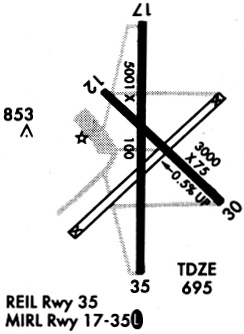
Runways
Runway Summary
| Runways: | 17/35 |
| Longest Runway: | 17/35 is 6800 ft (2073 m) long |
| Runways with an Instrument Approach: |
DUA Airport Runway Details
| Runway 17/35 | 6800 ft x 100 ft (2073 m x 30 m) | |
| Runway Length Source: | 3RD PARTY SURVEY as of 01/31/2020 | |
| Surface: | Asphalt - Good condition - No special surface treatment | |
| Runway Pavement Class: | 24 /F/B/X/U | |
| Runway Edge Lights: | Medium Intensity | |
Runway Weight Bearing Capacity (in thousands of pounds) |
||
| Single Wheel Landing Gear: | 35.0 | |
| Dual Wheel Landing Gear: | 50.0 | |
Runway 17 |
Runway 35 |
|
Elevation: |
699.1 | 693.7 |
Latitude: |
33-56-56.5413N | 33-55-49.2799N |
Longitude: |
096-23-41.9655W | 096-23-42.4492W |
|
Runway True Alignment: |
180 | 000 |
Glide Path Angle: |
3.0 degrees | 3.0 degrees |
Traffic Pattern: |
Left | Left |
Runway Markings Type: |
Nonprecision Instrument | Nonprecision Instrument |
Runway Markings Condition: |
Good | Good |
Object at End: |
TREES | TREES |
Object Height: |
30 | 35 |
Distance from End: |
687 | 741 |
Object Centerline Offset: |
210 ft. right of centerline | 170 ft. left of centerline |
Visual Glide Slope Indicators: |
4-Light PAPI On Left Side Of Runway | 4-Light PAPI On Left Side Of Runway |
Approach Light System: |
Omnidirectional Approach Lighting System | |
REIL: |
No | No |
Threshold Crossing Height: |
43 | 42 |
Services
Airframe Repair: |
None |
Powerplant Repair: |
None |
Bottled Oxygen: |
None |
Bulk Oxygen: |
None |
Fuel Available: |
100LL |
Landing Fees: |
No |
Parking: |
Tiedowns available |
Maps & Diagrams
DUA Sectional
Flight Planning
at skyvector.com
at skyvector.com