Location
Latitude: |
33-37-26.9000N (33.624139) |
Longitude: |
096-35-10.1000W (-96.586139) |
Elevation: |
746.1 feet MSL (227 m MSL) |
Magnetic Variation: |
2.6 E (as of April 2024 from WMM2020 model) |
Time Zone: |
UTC -6.0 (Standard Time) UTC -5.0 (Daylight Savings Time) |
From City: |
01 N.M. SE of Sherman, Texas |
Found On: |
Dallas-Ft Worth Chart |
FAA Region: |
ASW |
Contacts
Manager: |
Publicly owned: |
| JOHN HOOKER 1200 S. DEWEY AVE SHERMAN, TX 75090 903-868-4412 |
CITY OF SHERMAN PO BOX 1106 SHERMAN, TX 75090 903-892-4547 |
Operations
Airport Status: |
Operational |
Facility Use: |
Public |
Type: |
Airport |
Activation Date: |
08/1937 |
Control tower: |
No |
Attendance (Months/Days/Hours): |
Months/Days/Hours ALL/ALL/0800-1700 |
Boundary ARTCC: |
ZFW (Fort Worth) |
Responsible ARTCC: |
ZFW (Fort Worth) |
Lighting Schedule: |
SEE RMK |
Segmented Circle Indicator: |
Yes |
Traffic Pattern Altitude (MSL): |
1746 feet (532 m) |
NOTAMs Facility: |
FTW |
NOTAM-D Service: |
Yes |
International Airport of Entry: |
No |
Customs Landing Rights: |
No |
Military Landing Rights: |
Yes |
Civil/Military Joint Use: |
No |
Based Aircraft
| Single Engine: | 23 |
Annual Operations (as of 04/08/2019)
| Total Operations: | 8250 | |
| GA Local: | 4950 | 60.0% |
| GA Itinerant: | 3300 | 40.0% |
Communications
| CTAF: | 122.800 |
| Unicom: | 122.800 |
- APCH/DEP CTL SVC PRVDD BY FORT WORTH ARTCC (ZFW) ON FREQS 124.75/323.0 (GAINESVILLE RCAG).
Fixed Based Operators (FBOs) & Fuel
(Click on a business for detail)
Please help us keep this information up to date. This is a FREE SERVICE just like everything else on Airport Guide! If you see that a business needs to be added, modified, or deleted please fill out our Update Form.
To add, modify, or delete a business click here.
Please help us keep this information up to date. This is a FREE SERVICE just like everything else on Airport Guide! If you see that a business needs to be added, modified, or deleted please fill out our Update Form.
Area Code: 903 |
| Business Name | Frequency | Phone | Fuel Grade |
|---|---|---|---|
| South Centeral Flying Service
Update FBO info |
Unicom 122.8 | 893-6297 | 100LL |
Flight Service Stations
| Primary | Alternate | |
| FSS on Field: | N | |
| FSS Name (ID): | Fort Worth(FTW) | |
| Frequency: | ||
| Toll Free Phone: | 1-800-WX-BRIEF |
Instrument Procedures / Charts
FAA Terminal Procedures valid from 0901Z 03/21/24 to 0901Z 04/18/24.
There are various types of charts available for an airport. They are listed in the Page Type column. Here is a legend for those types:
APD - Airport Diagram
DP - Departure Procedure Charts
HOT - Hot Spots
IAP - Instrument Approach Procedure Charts
MIN - Minimums
STAR - Standard Terminal Arrival Charts
| Page Type | Page Name | Volume | Action Since Last Cycle |
|---|---|---|---|
| IAP | RNAV (GPS) RWY 16 | SC-2 | |
| IAP | RNAV (GPS) RWY 34 | SC-2 | |
| IAP | VOR/DME-A | SC-2 | |
| MIN | TAKEOFF MINIMUMS | SC-2 |
Terminal Procedures are only available for airports in several countries with more being added all the time. If you are looking for a specific country's charts, please send an email to support(at)airportguide.com stating the country name. This will be used to prioritize the implementation.
Navigation Aids (Navaids) near KSWI
| Dist (NM) | ID | Morse Code | Name | Type | Freq | True Hdg | Mag Hdg |
|---|---|---|---|---|---|---|---|
| 12.8 | DNI | _ . . _ . . . | Denison | NDB | 341 | 341 | 338 |
| 18.3 | BYP | _ . . . _ . _ _ . _ _ . | Bonham | VORTAC | 114.60 | 106 | 104 |
| 21.5 | URH | . . _ . _ . . . . . | Texoma | DME | 114.3 | 26 | 24 |
| 21.7 | VLY | . . . _ . _ . . _ . _ _ | Melisa | NDB | 421 | 180 | 177 |
| 36.8 | DT | _ . . _ | Pinck | NDB | 257 | 236 | 233 |
| 38.9 | MII | _ _ . . . . | Caddo Mills | NDB | 316 | 154 | 152 |
| 40.4 | AI | . _ . . | Addmo | NDB | 400 | 334 | 331 |
| 42.6 | MJF | _ _ . _ _ _ . . _ . | Arvilla | TACAN | 109.60 | 141 | 139 |
| 45.6 | ADM | . _ _ . . _ _ | Ardmore | VORTAC | 116.70 | 320 | 317 |
| 46.5 | SYW | . . . _ . _ _ . _ _ | Cash | NDB | 428 | 145 | 143 |
| 46.8 | CVE | _ . _ . . . . _ . | Cowboy | VOR-DME | 116.20 | 199 | 196 |
| 48.0 | DAL | _ . . . _ . _ . . | Dallas | VOT | 113.30 | 195 | 192 |
| 49.0 | PQF | . _ _ . _ _ . _ . . _ . | Mesquite | NDB | 248 | 176 | 173 |
| 50.7 | TTT | _ _ _ | Maverick | VOR-DME | 113.10 | 206 | 203 |
| 53.2 | FUZ | . . _ . . . _ _ _ . . | Ranger | VORTAC | 115.70 | 214 | 211 |
| 54.5 | AVZ | . _ . . . _ _ _ . . | Travis | NDB | 260 | 161 | 159 |
| 57.1 | PRX | . _ _ . . _ . _ . . _ | Paris | VOR-DME | 113.60 | 94 | 92 |
| 57.4 | JUG | . _ _ _ . . _ _ _ . | Jecca | NDB | 388 | 177 | 174 |
| 57.8 | HHW | . . . . . . . . . _ _ | Hugo | NDB | 323 | 64 | 62 |
| 58.2 | SLR | . . . . _ . . . _ . | Sulphur Springs | DME | 109 | 115 | 113 |
Nearby Airports with Fuel
Notices to Airmen (NOTAMS)
Remarks
| A110-1 | CITY ORDINANCE MANDATES ALL TAKE-OFFS ON RY 34 COMMENCE AT THLD MARKINGS. HIGH SPEED, LOW LEVEL PASSES ARE PROHIBITED. |
| A110-2 | WINDSOCK NOT VISIBLE FROM RWY 16 END. |
| A110-3 | FOR CD CTC FORT WORTH ARTCC AT 817-858-7584. |
| A110-4 | TWY MKGS & HOLD SHORT LINES POOR. HOLD LINE SIGNS NSTD WHITE. |
| A58-16 | 20 FT TREES, 0-199 FT DSTC, 220 R. |
| A58-34 | 30 FT TREES, 0-199 FT DSTC, 220 FT L. |
| A70-FUEL-10 | 0LL FUEL AVBL WITH MAJOR CREDIT CARD. |
| A81-APT | MIRL RWY 16/34 PRESET LOW INTST; TO INCR INTST AND ACTVT - CTAF. |
Runways
Runway Summary
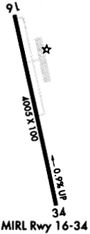
| Runways: | 16/34 |
| Longest Runway: | 16/34 is 4000 ft (1219 m) long |
| Runways with an Instrument Approach: |
KSWI Airport Runway Details
| Runway 16/34 | 4000 ft x 75 ft (1219 m x 23 m) | |
| Runway Length Source: | 3RD PARTY SURVEY as of 09/01/2010 | |
| Surface: | Asphalt - Fair condition - No special surface treatment | |
| Runway Edge Lights: | Medium Intensity | |
Runway Weight Bearing Capacity (in thousands of pounds) |
||
| Single Wheel Landing Gear: | 19.0 | |
Runway 16 |
Runway 34 |
|
Elevation: |
746.0 | 711.9 |
Latitude: |
33-37-46.0807N | 33-37-07.6737N |
Longitude: |
096-35-15.7626W | 096-35-04.3677W |
|
Runway True Alignment: |
166 | 346 |
Glide Path Angle: |
0.0 degrees | 0.0 degrees |
Traffic Pattern: |
Left | Left |
Runway Markings Type: |
Nonprecision Instrument | Nonprecision Instrument |
Runway Markings Condition: |
Good | Good |
Object at End: |
TREES | PLINE |
Object Height: |
30 | 14 |
Distance from End: |
530 | 700 |
Object Centerline Offset: |
250 ft. right of centerline | 0 ft. left and right of centerline |
Services
Airframe Repair: |
Major |
Powerplant Repair: |
Major |
Fuel Available: |
100LL, Jet A |
Landing Fees: |
No |
Parking: |
Hangars and tiedowns available |
Maps & Diagrams
KSWI Sectional
Flight Planning
at skyvector.com
at skyvector.com