Location
Latitude: |
33-04-04.2000N (33.067833) |
Longitude: |
096-03-55.2000W (-96.065333) |
Elevation: |
534.9 feet MSL (163 m MSL) |
Magnetic Variation: |
2.2 E (as of April 2024 from WMM2020 model) |
Time Zone: |
UTC -6.0 (Standard Time) UTC -5.0 (Daylight Savings Time) |
From City: |
04 N.M. SE of Greenville, Texas |
Found On: |
Dallas-Ft Worth Chart |
FAA Region: |
ASW |
Contacts
Manager: |
Publicly owned: |
| TY HELTON GREENVILLE MUNICIPAL AIRPORT, 101 MAJORS RD GREENVILLE, TX 75401 903-457-3168 |
CITY OF GREENVILLE 2821 WASHINGTON STREET, P O BOX 1049 GREENVILLE, TX 75403 903-457-3116 |
Operations
Airport Status: |
Operational |
Facility Use: |
Public |
Type: |
Airport |
Activation Date: |
07/1943 |
Control tower: |
Yes |
Attendance (Months/Days/Hours): |
Months/Days/Hours ALL/FRI-SAT/0730-1800 |
Boundary ARTCC: |
ZFW (Fort Worth) |
Responsible ARTCC: |
ZFW (Fort Worth) |
Lighting Schedule: |
SEE RMK |
Segmented Circle Indicator: |
Yes |
Traffic Pattern Altitude (MSL): |
1535 feet (468 m) |
NOTAMs Facility: |
GVT |
NOTAM-D Service: |
Yes |
International Airport of Entry: |
No |
Customs Landing Rights: |
No |
Military Landing Rights: |
Yes |
Civil/Military Joint Use: |
No |
Based Aircraft
| Single Engine: | 34 |
| Multi Engine: | 4 |
| Jet Engine: | 3 |
| GA Helicopters: | 1 |
Annual Operations (as of 11/03/2023)
| Total Operations: | 22000 | |
| GA Local: | 12960 | 58.9% |
| GA Itinerant: | 8640 | 39.3% |
| Military Aircraft: | 400 | 1.8% |
Communications
| CTAF: | 118.650 |
| Unicom: | 122.950 |
| Tower: | MAJORS 118.65 385.425 Hrs: 0730-1600 MON-FRI, IRREGULAR OTHER HOURS |
| Ground: | 121.7 335.8 |
| Approach: | FORT WORTH ARTCC |
| Departure: | FORT WORTH ARTCC |
| AWOS-3: | 133.425 (903-455-7703) |
| EMERG: | 121.5 |
| EMERG: | 243.0 |
| AFMC: | 349.6 |
- APCH/DEP CTL SVC PRVDD BY FORT WORTH ARTCC (ZFW) ON FREQS 132.025/360.75 (CUMBY RCAG).
- FREQ 349.6 SAME CONTROL 15048.
Fixed Based Operators (FBOs) & Fuel
(Click on a business for detail)
Please help us keep this information up to date. This is a FREE SERVICE just like everything else on Airport Guide! If you see that a business needs to be added, modified, or deleted please fill out our Update Form.
To add, modify, or delete a business click here.
Please help us keep this information up to date. This is a FREE SERVICE just like everything else on Airport Guide! If you see that a business needs to be added, modified, or deleted please fill out our Update Form.
Area Code: 903 |
| Business Name | Frequency | Phone | Fuel Grade |
|---|---|---|---|
| Love Aircraft Sales & Leasing
Update FBO info |
Unicom 122.95 | 455-5919 |
Flight Service Stations
| Primary | Alternate | |
| FSS on Field: | N | |
| FSS Name (ID): | Fort Worth(FTW) | |
| Frequency: | ||
| Toll Free Phone: | 1-800-WX-BRIEF |
Instrument Procedures / Charts
FAA Terminal Procedures valid from 0901Z 03/21/24 to 0901Z 04/18/24.
There are various types of charts available for an airport. They are listed in the Page Type column. Here is a legend for those types:
APD - Airport Diagram
DP - Departure Procedure Charts
HOT - Hot Spots
IAP - Instrument Approach Procedure Charts
MIN - Minimums
STAR - Standard Terminal Arrival Charts
| Page Type | Page Name | Volume | Action Since Last Cycle |
|---|---|---|---|
| APD | AIRPORT DIAGRAM | SC-2 | |
| IAP | ILS Y OR LOC Y RWY 17 | SC-2 | |
| IAP | ILS Z OR LOC Z RWY 17 | SC-2 | |
| IAP | RNAV (GPS) RWY 17 | SC-2 | |
| IAP | RNAV (GPS) RWY 35 | SC-2 | |
| IAP | TACAN RWY 17 | SC-2 | |
| IAP | TACAN RWY 35 | SC-2 | |
| IAP | VOR/DME RWY 17 | SC-2 | |
| MIN | ALTERNATE MINIMUMS | SC-2 | |
| MIN | TAKEOFF MINIMUMS | SC-2 |
Terminal Procedures are only available for airports in several countries with more being added all the time. If you are looking for a specific country's charts, please send an email to support(at)airportguide.com stating the country name. This will be used to prioritize the implementation.
Navigation Aids (Navaids) near GVT
| Dist (NM) | ID | Morse Code | Name | Type | Freq | True Hdg | Mag Hdg |
|---|---|---|---|---|---|---|---|
| 0.2 | MJF | _ _ . _ _ _ . . _ . | Arvilla | TACAN | 109.60 | 114 | 112 |
| 5.2 | SYW | . . . _ . _ _ . _ _ | Cash | NDB | 428 | 181 | 179 |
| 9.3 | MII | _ _ . . . . | Caddo Mills | NDB | 316 | 259 | 257 |
| 20.7 | AVZ | . _ . . . _ _ _ . . | Travis | NDB | 260 | 206 | 204 |
| 27.4 | SLR | . . . . _ . . . _ . | Sulphur Springs | DME | 109 | 73 | 71 |
| 28.0 | PQF | . _ _ . _ _ . _ . . _ . | Mesquite | NDB | 248 | 236 | 234 |
| 28.8 | VLY | . . . _ . _ . . _ . _ _ | Melisa | NDB | 421 | 294 | 292 |
| 29.4 | BYP | _ . . . _ . _ _ . _ _ . | Bonham | VORTAC | 114.60 | 343 | 341 |
| 33.6 | JUG | . _ _ _ . . _ _ _ . | Jecca | NDB | 388 | 224 | 222 |
| 36.9 | UIM | . . _ . . _ _ | Quitman | DME | 114 | 107 | 105 |
| 41.4 | DAL | _ . . . _ . _ . . | Dallas | VOT | 113.30 | 252 | 250 |
| 42.0 | PRX | . _ _ . . _ . _ . . _ | Paris | VOR-DME | 113.60 | 47 | 45 |
| 43.5 | CVE | _ . _ . . . . _ . | Cowboy | VOR-DME | 116.20 | 256 | 254 |
| 49.4 | TY | _ _ . _ _ | Indoo | NDB | 320 | 142 | 140 |
| 50.5 | TTT | _ _ _ | Maverick | VOR-DME | 113.10 | 256 | 254 |
| 53.5 | CQY | _ . _ . _ _ . _ _ . _ _ | Cedar Creek | VORTAC | 114.80 | 188 | 186 |
| 54.2 | TYR | _ _ . _ _ . _ . | Tyler | VOR-DME | 114.20 | 141 | 139 |
| 54.6 | DNI | _ . . _ . . . | Denison | NDB | 341 | 326 | 324 |
| 55.1 | URH | . . _ . _ . . . . . | Texoma | DME | 114.3 | 342 | 340 |
| 55.8 | AHX | . _ . . . . _ . . _ | Athens | NDB | 269 | 167 | 165 |
Nearby Airports with Fuel
Notices to Airmen (NOTAMS)
Remarks
| A110-10 | WHEN ATCT CLSD AND THERE IS AN EMERG OR INCIDENT ON ARPT, CTC 903-457-5333. |
| A110-11 | ACFT NOT VSB FM OPPOSITE END OF RWY. |
| A110-2 | MILITARY USE: JASU - 1(B-10) 1(B-10A) 1(MD-3) 1(MA-1) 1(MA-3). |
| A110-3 | 89 FT HIGH INTST RADIO FREQ ANT 3700 FT EAST OF RWY 35 AT END OF ABNDD PAVEMENT. |
| A110-5 | TWY E LGTS 47 FT FM PAVEMENT EDGE. |
| A110-6 | TWY A CLSD. |
| A110-8 | PPR FOR PAJA ONTO MAJORS FIELD. |
| A110-9 | WHEN ATCT CLSD, FOR CD CTC FORT WORTH ARTCC AT 817-858-7584. |
| A16 | THELTON@CI.GREENVILLE.TX.US ALT PHONE 214-960-9294 |
| A70-FUEL-10 | 0LL 100LL SELF SVC AVBL 24 HRS. |
| A81-APT | ACTVT MALS RWY 17; REIL RWY 35; MIRL RWY 17/35 - CTAF. |
| A95 | NMRS MIL ACFT ON FLD FOR MODIFICATION. |
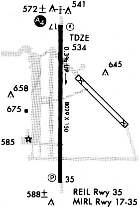
Runways
Runway Summary
| Runways: | 17/35 |
| Longest Runway: | 17/35 is 8030 ft (2448 m) long |
| Runways with an Instrument Approach: | 17 |
GVT Airport Runway Details
| Runway 17/35 | 8030 ft x 150 ft (2448 m x 46 m) | |
| Runway Length Source: | 3RD PARTY SURVEY as of 11/15/2011 | |
| Surface: | Asphalt - Good condition - No special surface treatment | |
| Runway Edge Lights: | Medium Intensity | |
Runway Weight Bearing Capacity (in thousands of pounds) |
||
| Single Wheel Landing Gear: | 26.0 | |
Runway 17 |
Runway 35 |
|
Elevation: |
519.6 | 524.3 |
Latitude: |
33-04-43.9512N | 33-03-24.5106N |
Longitude: |
096-03-54.5590W | 096-03-55.7595W |
|
Runway True Alignment: |
181 | 001 |
ILS Type: |
ILS/DME | |
Glide Path Angle: |
3.0 degrees | 3.0 degrees |
Traffic Pattern: |
Left | Left |
Runway Markings Type: |
Precision Instrument | Nonprecision Instrument |
Runway Markings Condition: |
Good | Good |
Object at End: |
TREES | TREES |
Object Height: |
18 | 34 |
Distance from End: |
337 | 955 |
Object Centerline Offset: |
140 ft. right of centerline | 0 ft. left of centerline |
Visual Glide Slope Indicators: |
4-Light PAPI On Left Side Of Runway | 4-Light PAPI On Left Side Of Runway |
Approach Light System: |
1,400 Foot Medium Intensity Approach Lighting System | |
REIL: |
Yes | |
Threshold Crossing Height: |
74 | 66 |
Services
Airframe Repair: |
Major |
Powerplant Repair: |
Major |
Fuel Available: |
100LL, Jet A |
Landing Fees: |
No |
Parking: |
Hangars and tiedowns available |
Maps & Diagrams
GVT Sectional
Flight Planning
at skyvector.com
at skyvector.com