Location
Latitude: |
32-03-34.1540N (32.059487) |
Longitude: |
082-09-12.8760W (-82.153577) |
Elevation: |
195.6 feet MSL (60 m MSL) |
Magnetic Variation: |
6.8 W (as of April 2024 from WMM2020 model) |
Time Zone: |
UTC -5.0 (Standard Time) UTC -4.0 (Daylight Savings Time) |
From City: |
03 N.M. SW of Reidsville, Georgia |
Found On: |
Atlanta Chart |
FAA Region: |
ASO |
Contacts
Manager: |
Publicly owned: |
| WIL SMITH BOX 2351 REIDSVILLE, GA 30453 (912) 246-2500 |
CITY OF REIDSVILLE PO BOX 730 REIDSVILLE, GA 30453 912-557-4786 |
Operations
Airport Status: |
Operational |
Facility Use: |
Public |
Type: |
Airport |
Activation Date: |
06/1974 |
Control tower: |
No |
Attendance (Months/Days/Hours): |
Months/Days/Hours Unattended |
Boundary ARTCC: |
ZJX (Jacksonville) |
Responsible ARTCC: |
ZJX (Jacksonville) |
Lighting Schedule: |
SEE RMK |
Segmented Circle Indicator: |
Yes |
Traffic Pattern Altitude (MSL): |
1196 feet (365 m) |
NOTAMs Facility: |
MCN |
NOTAM-D Service: |
Yes |
Military Landing Rights: |
Yes |
Civil/Military Joint Use: |
No |
Based Aircraft
| Single Engine: | 13 |
| GA Helicopters: | 2 |
Annual Operations (as of 12/31/2021)
| Total Operations: | 8500 | |
| GA Local: | 3500 | 41.2% |
| GA Itinerant: | 2500 | 29.4% |
| Military Aircraft: | 2500 | 29.4% |
Communications
| CTAF: | 122.900 |
| AWOS-3PT: | 128.325 (912-557-0011) |
- APCH/DEP SVC PRVDD BY JACKSONVILLE ARTCC ON FREQS 127.575/269.025 (ALMA RCAG).
Fixed Based Operators (FBOs) & Fuel
(Click on a business for detail)
Please help us keep this information up to date. This is a FREE SERVICE just like everything else on Airport Guide! If you see that a business needs to be added, modified, or deleted please fill out our Update Form.
To add, modify, or delete a business click here.
Please help us keep this information up to date. This is a FREE SERVICE just like everything else on Airport Guide! If you see that a business needs to be added, modified, or deleted please fill out our Update Form.
Area Code: 912 |
| Business Name | Frequency | Phone | Fuel Grade |
|---|
Flight Service Stations
| Primary | Alternate | |
| FSS on Field: | N | |
| FSS Name (ID): | Macon(MCN) | |
| Frequency: | ||
| Toll Free Phone: | 1-800-WX-BRIEF |
Instrument Procedures / Charts
FAA Terminal Procedures valid from 0901Z 03/21/24 to 0901Z 04/18/24.
There are various types of charts available for an airport. They are listed in the Page Type column. Here is a legend for those types:
APD - Airport Diagram
DP - Departure Procedure Charts
HOT - Hot Spots
IAP - Instrument Approach Procedure Charts
MIN - Minimums
STAR - Standard Terminal Arrival Charts
| Page Type | Page Name | Volume | Action Since Last Cycle |
|---|---|---|---|
| IAP | RNAV (GPS) RWY 11 | SE-4 | |
| MIN | ALTERNATE MINIMUMS | SE-4 | |
| MIN | TAKEOFF MINIMUMS | SE-4 |
Terminal Procedures are only available for airports in several countries with more being added all the time. If you are looking for a specific country's charts, please send an email to support(at)airportguide.com stating the country name. This will be used to prioritize the implementation.
Navigation Aids (Navaids) near KRVJ
| Dist (NM) | ID | Morse Code | Name | Type | Freq | True Hdg | Mag Hdg |
|---|---|---|---|---|---|---|---|
| 0.1 | RVJ | . _ . . . . _ . _ _ _ | Prison | NDB | 424 | 148 | 155 |
| 12.3 | UQN | . . _ _ _ . _ _ . | Onyun | NDB | 372 | 323 | 330 |
| 16.3 | CWV | _ . _ . . _ _ . . . _ | Claxton | NDB | 395 | 60 | 67 |
| 24.1 | BHC | _ . . . . . . . _ . _ . | Baxley | NDB | 376 | 210 | 217 |
| 27.4 | AZE | . _ _ _ . . . | Hazlehurst | NDB | 414 | 246 | 253 |
| 32.8 | BZ | _ . . . _ _ . . | Bullo | NDB | 407 | 49 | 56 |
| 33.3 | JES | . _ _ _ . . . . | Slover | NDB | 340 | 155 | 162 |
| 35.5 | MOQ | _ _ _ _ _ _ _ . _ | Mc Intosh | NDB | 263 | 112 | 119 |
| 36.2 | AMG | . _ _ _ _ _ . | Alma | VORTAC | 115.10 | 210 | 217 |
| 37.1 | MQW | _ _ _ _ . _ . _ _ | Mc Rae | NDB | 280 | 273 | 280 |
| 39.4 | EEX | . . _ . . _ | Emanuel County | NDB | 309 | 337 | 344 |
| 42.0 | SA | . . . . _ | Mavis | NDB | 368 | 84 | 91 |
| 45.3 | JYL | . _ _ _ _ . _ _ . _ . . | Sylvania | NDB | 245 | 38 | 45 |
| 45.7 | DBN | _ . . _ . . . _ . | Dublin | VORTAC | 113.10 | 311 | 318 |
| 45.8 | AY | . _ _ . _ _ | Wiket | NDB | 219 | 195 | 202 |
| 48.5 | SAV | . . . . _ . . . _ | Savannah Travis Fld | VOT | 111.00 | 84 | 91 |
| 48.8 | SAV | . . . . _ . . . _ | Savannah | VORTAC | 115.95 | 83 | 90 |
| 50.4 | DB | _ . . _ . . . | Creke | NDB | 251 | 300 | 307 |
| 51.0 | LNH | . _ . . _ . . . . . | Millen | NDB | 205 | 10 | 17 |
| 51.0 | EZM | . _ _ . . _ _ | Eastman | NDB | 366 | 275 | 281 |
Nearby Airports with Fuel
Notices to Airmen (NOTAMS)
Remarks
| A110-1 | FOR CD CTC JACKSONVILLE ARTCC AT 904-845-1592. |
| A14 | CHAIR OF AIRPORT AUTHORITY |
| A70-FUEL-10 | 0LL FUEL 24 HR CREDIT CARD SVC AVBL. |
| A81-APT | ACTVT PAPI RYS 11 & 29, MIRL RY 11/29 PRESET LOW INTS DUSK-0230; TO INCR INTS & ACTVT AFTER 0230 - CTAF. |
Runways
Runway Summary
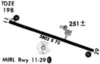
| Runways: | 11/29 |
| Longest Runway: | 11/29 is 5003 ft (1525 m) long |
| Runways with an Instrument Approach: |
KRVJ Airport Runway Details
| Runway 11/29 | 5003 ft x 75 ft (1525 m x 23 m) | |
| Runway Length Source: | 3RD PARTY SURVEY as of 03/19/2019 | |
| Surface: | Asphalt - Good condition - No special surface treatment | |
| Runway Edge Lights: | Medium Intensity | |
Runway Weight Bearing Capacity (in thousands of pounds) |
||
| Single Wheel Landing Gear: | 30.0 | |
Runway 11 |
Runway 29 |
|
Elevation: |
164.0 | 195.4 |
Latitude: |
32-03-41.8214N | 32-03-26.4856N |
Longitude: |
082-09-40.5127W | 082-08-45.2400W |
|
Runway True Alignment: |
108 | 288 |
Glide Path Angle: |
3.0 degrees | 3.0 degrees |
Traffic Pattern: |
Left | Left |
Runway Markings Type: |
Nonprecision Instrument | Nonprecision Instrument |
Runway Markings Condition: |
Fair | Fair |
Visual Glide Slope Indicators: |
2-Light PAPI On Left Side Of Runway | 2-Light PAPI On Left Side Of Runway |
Threshold Crossing Height: |
40 | 31 |
Services
Bottled Oxygen: |
None |
Bulk Oxygen: |
None |
Fuel Available: |
100LL, Jet A |
Landing Fees: |
No |
Parking: |
Tiedowns available |
Maps & Diagrams
KRVJ Sectional
Flight Planning
at skyvector.com
at skyvector.com