Location
Latitude: |
31-15-32.5270N (31.259035) |
Longitude: |
081-27-58.7390W (-81.466316) |
Elevation: |
25.6 feet MSL (8 m MSL) |
Magnetic Variation: |
7.1 W (as of April 2024 from WMM2020 model) |
Time Zone: |
UTC -5.0 (Standard Time) UTC -4.0 (Daylight Savings Time) |
From City: |
05 N.M. N of Brunswick, Georgia |
Found On: |
Jacksonville Chart |
FAA Region: |
ASO |
Contacts
Manager: |
Publicly owned: |
| ROBERT J. BURR 295 AVIATION PKWY. SUITE 205 BRUNSWICK, GA 31525 912-265-2070 |
GLYNN COUNTY AIRPORT COMMISSION 295 AVIATION PARKWAY SUITE 205 BRUNSWICK, GA 31525 (912) 265-2070 |
Operations
Airport Status: |
Operational |
Facility Use: |
Public |
Type: |
Airport |
Activation Date: |
02/1944 |
Control tower: |
No |
Attendance (Months/Days/Hours): |
Months/Days/Hours ALL/ALL/0700-2000 |
Boundary ARTCC: |
ZJX (Jacksonville) |
Responsible ARTCC: |
ZJX (Jacksonville) |
Lighting Schedule: |
SEE RMK |
Segmented Circle Indicator: |
Yes |
Traffic Pattern Altitude (MSL): |
1026 feet (313 m) |
NOTAMs Facility: |
BQK |
NOTAM-D Service: |
Yes |
International Airport of Entry: |
No |
Customs Landing Rights: |
Yes |
Military Landing Rights: |
Yes |
Civil/Military Joint Use: |
No |
Aircraft Rescue and Firefighting: |
Class I ARFF Index: A Air Carrier Service: Scheduled Certification Date: 03/1982 |
Based Aircraft
| Single Engine: | 26 |
| Multi Engine: | 2 |
Annual Operations (as of 06/01/2022)
| Total Operations: | 20914 | |
| Commercial: | 1095 | 5.2% |
| Air Taxi: | 1200 | 5.7% |
| GA Local: | 8262 | 39.5% |
| GA Itinerant: | 9857 | 47.1% |
| Military Aircraft: | 500 | 2.4% |
Communications
| CTAF: | 123.000 |
| Unicom: | 123.000 |
| AWOS-3: | 124.175 (912-261-0531) |
- APCH/DEP SVC PRVDD BY JACKSONVILLE ARTCC (ZJX) ON FREQS 126.75/277.4 (BRUNSWICK RCAG).
- CLNC DEL PRVDD BY JACKSONVILLE ARTCC (ZJX) ON FREQS 126.75/277.4 (BRUNSWICK RCAG).
Fixed Based Operators (FBOs) & Fuel
(Click on a business for detail)
Please help us keep this information up to date. This is a FREE SERVICE just like everything else on Airport Guide! If you see that a business needs to be added, modified, or deleted please fill out our Update Form.
To add, modify, or delete a business click here.
Please help us keep this information up to date. This is a FREE SERVICE just like everything else on Airport Guide! If you see that a business needs to be added, modified, or deleted please fill out our Update Form.
Area Code: 912 |
| Business Name | Frequency | Phone | Fuel Grade |
|---|---|---|---|
| Glynco-Taj Aviation
Update FBO info |
Unicom 122.8 | 264-9200 | 100LL, Jet A |
Flight Service Stations
| Primary | Alternate | |
| FSS on Field: | N | |
| FSS Name (ID): | Macon(MCN) | |
| Frequency: | ||
| Toll Free Phone: | 1-800-WX-BRIEF |
Instrument Procedures / Charts
FAA Terminal Procedures valid from 0901Z 03/21/24 to 0901Z 04/18/24.
There are various types of charts available for an airport. They are listed in the Page Type column. Here is a legend for those types:
APD - Airport Diagram
DP - Departure Procedure Charts
HOT - Hot Spots
IAP - Instrument Approach Procedure Charts
MIN - Minimums
STAR - Standard Terminal Arrival Charts
| Page Type | Page Name | Volume | Action Since Last Cycle |
|---|---|---|---|
| APD | AIRPORT DIAGRAM | SE-4 | |
| IAP | ILS OR LOC RWY 07 | SE-4 | |
| IAP | RNAV (GPS) RWY 07 | SE-4 | |
| IAP | RNAV (GPS) RWY 25 | SE-4 | |
| IAP | VOR/DME-B | SE-4 | |
| MIN | ALTERNATE MINIMUMS | SE-4 | |
| MIN | TAKEOFF MINIMUMS | SE-4 |
Terminal Procedures are only available for airports in several countries with more being added all the time. If you are looking for a specific country's charts, please send an email to support(at)airportguide.com stating the country name. This will be used to prioritize the implementation.
Navigation Aids (Navaids) near BQK
| Dist (NM) | ID | Morse Code | Name | Type | Freq | True Hdg | Mag Hdg |
|---|---|---|---|---|---|---|---|
| 1.0 | BQK | _ . . . _ _ . _ _ . _ | Brunswick | VOT | 111.00 | 27 | 34 |
| 12.6 | SSI | . . . . . . . . | Brunswick | VORTAC | 109.80 | 175 | 182 |
| 27.8 | JES | . _ _ _ . . . . | Slover | NDB | 340 | 309 | 316 |
| 34.4 | MOQ | _ _ _ _ _ _ _ . _ | Mc Intosh | NDB | 263 | 356 | 363 |
| 47.4 | JAX | . _ _ _ . _ _ . . _ | Jacksonville Intl | VOT | 111.00 | 194 | 201 |
| 47.9 | AY | . _ _ . _ _ | Wiket | NDB | 219 | 275 | 282 |
| 48.1 | SVN | . . . . . . _ _ . | Hunter | VOR-DME | 111.60 | 20 | 27 |
| 50.7 | EYA | . _ . _ _ . _ | Eastport | NDB | 357 | 188 | 195 |
| 50.7 | JA | . _ _ _ . _ | Dinns | NDB | 344 | 200 | 207 |
| 51.0 | SV | . . . . . . _ | Wassa | NDB | 335 | 28 | 35 |
| 52.3 | NRB | _ . . _ . _ . . . | Mayport | TACAN | 111.40 | 177 | 184 |
| 52.7 | SA | . . . . _ | Mavis | NDB | 368 | 7 | 14 |
| 53.8 | SAV | . . . . _ . . . _ | Savannah Travis Fld | VOT | 111.00 | 14 | 21 |
| 54.5 | BHC | _ . . . . . . . _ . _ . | Baxley | NDB | 376 | 300 | 307 |
| 55.0 | SAV | . . . . _ . . . _ | Savannah | VORTAC | 115.95 | 14 | 21 |
| 55.3 | CRG | _ . _ . . _ . _ _ . | Craig | VORTAC | 114.50 | 182 | 189 |
| 55.9 | AMG | . _ _ _ _ _ . | Alma | VORTAC | 115.10 | 287 | 294 |
| 55.9 | AYS | . _ _ . _ _ . . . | Waycross | VORTAC | 110.20 | 270 | 277 |
| 59.4 | RVJ | . _ . . . . _ . _ _ _ | Prison | NDB | 424 | 324 | 331 |
| 59.8 | CWV | _ . _ . . _ _ . . . _ | Claxton | NDB | 395 | 339 | 346 |
Nearby Airports with Fuel
Notices to Airmen (NOTAMS)
Remarks
| A110-1 | BIRDS ON & IN VCNTY OF ARPT DURG HVY RAINS & HIGH NORTHEASTERLY WINDS. |
| A110-3 | DEER ON & INVOF ARPT. |
| A110-4 | USE CTN DUE TO CONGESTED ASP WITH TURBINE, NON-TURBINE AND TRAINING ACFT. KSSI LOCATED 7NM SE. |
| A110-5 | ALL VFR ACFT ADHERE TO STD LH TFC PAT. |
| A110-6 | ALL ARRIVALS AND DEP, INCLUDING ACFT FLYING INST APPROACHES, ARE REQSTD TO RPRT 10 MILES FROM THE AP, INTNS AND PSN REPORTS TO 'BRUNSWICK' CTAF 123.00. |
| A110-7 | ADDITIONAL APT SAFETY BULLETINS POSTED AT WWW.FLYGCAIRPORTS.COM/SAFETY. |
| A110-9 | FOR CD CTC JACKSONVILLE ARTCC AT 904-845-1592. |
| A17 | PPR FOR SVC & FUEL AFT HRS CALL (912) 264-9200. |
| A26 | PPR 24 HRS FOR CHARTER ACFT OPS WITH MORE THAN 30 PASSENGER SEATS CALL AMGR 912-265-2070. |
| A32-07/25 | 25 FT FULL STRENGTH SHOULDERS EACH SIDE. |
| A81-APT | ACTVT MALSR RWY 07; REIL RWY 25; PAPI RWY 07 & 25; HIRL RWY 07/25 - CTAF. |
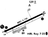
Runways
Runway Summary
| Runways: | 07/25 |
| Longest Runway: | 07/25 is 8001 ft (2439 m) long |
| Runways with an Instrument Approach: | 07 |
BQK Airport Runway Details
| Runway 07/25 | 8001 ft x 150 ft (2439 m x 46 m) | |
| Runway Length Source: | 3RD PARTY SURVEY as of 10/30/2014 | |
| Surface: | Asphalt - Good condition - Saw-cut or plastic grooved | |
| Runway Pavement Class: | 50 /F/B/X/T | |
| Runway Edge Lights: | High Intensity | |
Runway Weight Bearing Capacity (in thousands of pounds) |
||
| Single Wheel Landing Gear: | 120.0 | |
| Dual Wheel Landing Gear: | 190.0 | |
| Dual Tandem Wheel Landing Gear: | 323.0 | |
Runway 07 |
Runway 25 |
|
Elevation: |
19.8 | 20.3 |
Latitude: |
31-15-16.0160N | 31-15-49.0337N |
Longitude: |
081-28-40.6263W | 081-27-16.8476W |
|
Runway True Alignment: |
065 | 245 |
ILS Type: |
ILS | |
Glide Path Angle: |
3.0 degrees | 3.0 degrees |
Traffic Pattern: |
Left | Left |
Runway Markings Type: |
Precision Instrument | Precision Instrument |
Runway Markings Condition: |
Fair | Fair |
Visual Glide Slope Indicators: |
4-Light PAPI On Left Side Of Runway | 4-Light PAPI On Left Side Of Runway |
Approach Light System: |
1,400 Foot Medium Intensity Approach Lighting System With Runway Alignment Indicator Lights | |
REIL: |
No | Yes |
Threshold Crossing Height: |
58 | 50 |
Services
Airframe Repair: |
None |
Powerplant Repair: |
None |
Bottled Oxygen: |
None |
Bulk Oxygen: |
None |
Fuel Available: |
Jet A |
Landing Fees: |
No |
Parking: |
Tiedowns available |
Maps & Diagrams
BQK Sectional
Flight Planning
at skyvector.com
at skyvector.com